

Alabama map
Central Alabama map
The sheet's index lists 34 highways; I-20, I-59 and I-65 cross the most grid squares. Things to do inside the boundary: 16th Street Baptist Church, Alabama Adventure & Splash Adventure and Alabama Jazz Hall of Fame. Also on it: Alabaster, Alexander City and Bessemer.
Open the map (PDF, US Letter)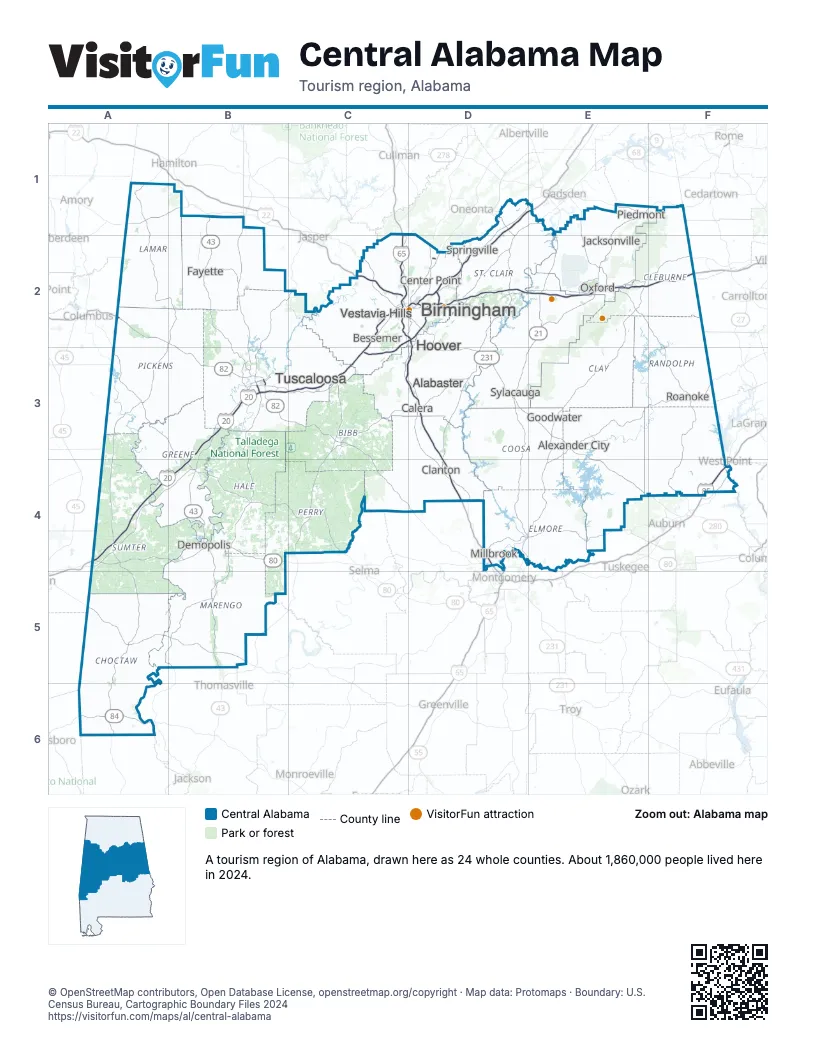
Highway index of Central Alabama
Each highway on the sheet and the grid squares it crosses.
- I-20A4, B3, B4, C2, C3, D2, E2, F2
- I-22C2
- I-59A4, B3, B4, C2, C3, D1, D2, E1
- I-65C1, C2, C3, D2, D3, D4
- I-85F4
- I-359B3
- I-459C2, C3, D2
- US 11B3, B4, C2, C3
- US 31C2, D2
- US 43B1, B2, B3, B4, B5
- US 78C2, D2
- US 80A4, B4
- US 82A2, B2, B3, C3, C4, D4
- US 84A6
- US 231D3, D4
- US 278E1, F1
- US 280C2, D2, D3, E3, E4
- US 431E1, E2, F2, F3, F4
- AL 5C2, C3
- GA 6F1
- AL 14B4, D4
- AL 21D3, D4, E1, E2, E3
- AL 22E3
- AL 25B4
- AL 28A4, B4, B5
- AL 49E4
- AL 50E4
- AL 69B3, B4, B5
- AL 76D3
- AL 77E2
- AL 171B1, B2, B3
- AL 219C3
- AL 303B5
- AL 959D2
Things to do on the Central Alabama map
- 16th Street Baptist Church
- Alabama Adventure & Splash Adventure
- Alabama Jazz Hall of Fame
- Alabama Museum of Natural History
- Arlington Antebellum Home & Gardens
- Barber Vintage Motorsports Museum
- Bessemer Hall of History
- Birmingham Civil Rights Institute
- Birmingham Civil Rights National Monument
- Birmingham Museum of Art
- Birmingham Zoo
- Cheaha State Park
- Freedom Riders National Monument
- Heart of Dixie Railroad Museum
- Horseshoe Bend National Military Park
- International Motorsports Hall of Fame
- Janney Furnace Confederate and Native American Museum
- Majestic Caverns
- McWane Science Center
- Moundville Archaeological Park
- Paul W. Bryant Museum
- Quintard Mall
- Riverchase Galleria
- Sloss Furnaces
- Southern Museum of Flight
- Talladega Superspeedway
- Tannehill Ironworks Historical State Park
- The Summit
- University Mall
- Vulcan Park & Museum
Places on the map
- Alabaster
- Alexander City
- Bessemer
- Birmingham
- Calera
- Center Point
- Clanton
- Demopolis
- Fayette
- Goodwater
- Hoover
- Jacksonville
- Millbrook
- Oxford
- Piedmont
- Roanoke
- Springville
- Sylacauga
- Tuscaloosa
- Vestavia Hills
Next to Central Alabama
- North Alabama map
- South Alabama map
- Northwest Georgia
- Presidential Pathways
- Mississippi Hills
- Mississippi Pines
© OpenStreetMap contributors, Open Database License, openstreetmap.org/copyright · Map data: Protomaps · Boundary: U.S. Census Bureau, Cartographic Boundary Files 2024