

Arkansas map
Benton map
About 38,088 people live here (Census Bureau, 2024 estimate). The sheet's index lists 300 streets; I-30 Frontage Road, Military Road and Alcoa Road cross the most grid squares. Also on it: Hurricane Lake, Hickory Square and Saline Memorial Hospital.
Open the map (PDF, US Letter)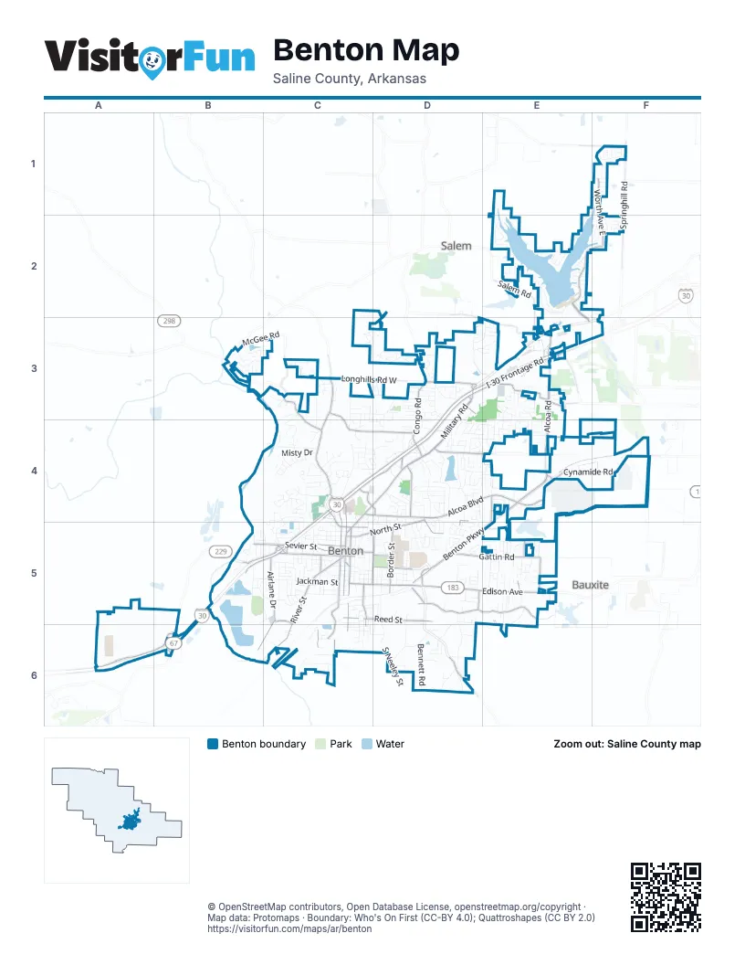
Street index of Benton
Each street on the sheet and the grid squares it crosses.
- Military RoadD3, C4, D4, C5
- East Carpenter StreetC5
- US Highway 67B6
- Browning AvenueD3
- I-30 Frontage RoadD3, E3, C4, D4, B5, C5, A6, B6
- Alcoa RoadE3, C4, D4, E4
- Edison AvenueC5, D5, E5
- Benton ParkwayE4, D5, E5
- Old Hot Springs HighwayB3, C3, C4
- Congo RoadD3, D4
- West South StreetB5, C5
- Boone RoadE3
- South East StreetC5, C6
- Alcoa BoulevardD4, E4
- Longhills Road EastD3
- North Main StreetC4, C5
- North Market StreetC4, C5
- State Highway 35D6
- South Main StreetC5
- West Conway StreetC5
- North East StreetC5
- West Carpenter StreetC4, C5
- South Street EastC5
- Leander StreetC5
- East Ashley StreetC5
- Lincoln RoadD4
- Worth Avenue EastF1, E2, F2
- River StreetC5, C6
- Silica Heights RoadD5, E5
- Cynamide RoadE4, F4
- South Market StreetC5, C6
- Airlane DriveC5, B6, C6
- Shenandoah RoadC3, C4, D4
- Gattin RoadD5, E5
- West Sevier StreetB5, C5
- Reed StreetC5, D5
- East North StreetD4, C5, D5
- Sidell RoadD4, E4, D5, E5
- Northshore DriveD4, E4
- Salt Creek RoadC3, C4
- Springhill RoadF1, F2
- Waterfall WayE2, E3
- Smithers DriveD4
- East Sevier StreetC5, D5
- Sleepy Village RoadE4, F4
- North Border StreetD5
- Hoover StreetD5
- North Summit RoadE5
- Ferguson DriveC4, D4
- Scott Salem RoadD3, E3
- South Richard StreetC5, C6
- North Aaronfield RoadE5
- North Shady LaneE4, E5
- Fernwood StreetD4, D5
- North 4th StreetD5
- Shady TrailE4
- Salem RoadE2, E3
- FernwoodE5
- South Border StreetD5
- South 4th StreetC5, D5
- Stewart StreetC5, C6
- 2nd Street OverpassC5
- Kidd LaneD5
- Canterbury StreetD5
- Mary Kay BoulevardC5
- Longhills Road WestC3, D3
- McGee RoadB3, C3
- Northlake RoadF1
- Mount Carmel RoadE3
- Bell StreetC5
- Mulberry Salem RoadB3
- East Shenandoah RoadD4
- South Neeley StreetD5, D6
- Sharron RoadC3, C4
- Jackman StreetB5, C5
- Augusta DriveD3, E3
- Nature WayC3, D3
- South Shoreline BoulevardE1, F1, E2
- River Oaks DriveC3, C4
- Bennett RoadD6
- Pierce Manse LoopF1
- Winchester DriveD3, E3, D4
- Miller CoveC4
- Chatfield RoadD5, D6
- Willow StreetC5
- Worth Avenue WestE2
- Sorrell RoadD5, D6
- Misty DriveC4
- West Ashley StreetC5
- Westminster AvenueE2
- Edgehill DriveD4, D5
- Heritage Farm DriveE3, E4
- Henry StreetB5, C5
- Wright AvenueC4
- Kenwood RoadC4
- West Smith StreetC5
- Duncan RoadC3, C4
- West Hazel StreetC5
- Bird StreetC5
- Citizens DriveB5, C5
- Lake Point CircleE2
- Woodland DriveC4, C5
- Jameson StreetD4
- Pinewood DriveC4, C5
- Denise DriveD3, D4, E4
- Columbia AvenueC5, D5
- Prysock RoadD6
- Pope DriveE5
- West Pine StreetC5
- West Cross StreetC5
- Heights RoadC4
- Lyledale RoadC4
- Brookview StreetD4
- Coldwater DriveB3, C3
- East Lakeview DriveD4
- Greenbriar StreetD4, E4
- Westshore AvenueE2
- North Olive StreetC4, C5
- Rosewood DriveD4, D5
- Hicks RoadD4, D5
- Cole DriveE5
- Frendall DriveD3, D4
- Lillian StreetC4, C5
- Medical Park DriveC4, C5
- Church StreetE5
- Rock Creek DriveC4
- Ridge RoadD5, D6
- Saddle Oaks DriveC4
- Cedarhurst DriveD4
- South Shady LaneE5
- Elaine StreetC4, D4
- CoxD5
- West Maple StreetC5
- Berwick RoadC3, D3
- Lynnwood DriveD4
- Millbrook DriveE4
- Genesis DriveD5
- Hartford Hills DriveC3
- WestminsterE2
- Harmon DriveD5
- Troy DriveD3
- Street Rod LaneE4
- Whitlock DriveD5
- West Lakeview DriveD4
- Dogwood DriveC4
- Palm StreetC5, D5
- West Narroway StreetC5
- Hickory RidgeC4, D4
- Oakbrook DriveE3, E4
- King RoadB5
- Milburn DriveD6
- Dixie StreetC5, C6
- Denton StreetC4, D4, C5
- Hazelwood DriveE3
- SchleyC5, D5
- Watson LaneC5, D5
- Dale AvenueC5, B6
- Christy LaneC6
- Fairfield RoadB5
- South Richards StreetC5, C6
- Mc Curdy RoadC4
- Liberty StreetD5, D6
- Clover Hill LaneE3, E4
- Thomas RoadD4
- Hidden Meadows DriveE5
- Summerwood DriveD3
- West North StreetC5
- Riviera DriveE2
- Sunset DriveD4, D5
- East Maple StreetC5, D5
- Volcanic DriveC4
- Janet StreetD4, E4
- Jefferson StreetC5
- Azalea CircleC4
- Caribbean Drive WestE2
- Deerfield RoadD3
- Beverly DriveC4
- Cherry CrossingD5
- South Pearson StreetC5
- Houston DriveD5
- Cambridge CircleC4
- Glenda LaneD3
- Chris DriveD4
- Cedar StreetC5, C6
- South 1st StreetC5
- Coats RoadE4
- North CoxD5
- Muaqua AvenueC5
- South 2nd StreetC5
- Earle DriveC3, D3, C4, D4
- McCright StreetC4, C5
- New Hope RoadD5, D6
- Social Hill RoadD6
- South 3rd StreetC5
- Ranchwood DriveD4
- Summerwood CoveD3
- Palm Beach AvenueF2
- Stonewall DriveE4
- Kensington DriveE2
- Leawood DriveD3
- Lexington AvenueF2
- Venturi DriveC5
- Legacy Village DriveE3
- Carwin DriveD4
- School DriveD5
- Durango DriveB3
- Grayson DriveE2
- Summit RoadE5, E6
- Foutain Lakes RoadD3, D4
- River HeightsC3
- Gum StreetC5, C6
- Teresa DriveC4, C5
- West Walnut StreetC5
- Gray StreetD5
- Arkansas AvenueE4
- Ginger DriveD3
- Redford CourtC3
- Commerce StreetC5
- Banner StreetC5
- Bridgewater DriveD4
- Holland Park RoadC5
- Wall StreetE2
- Cody RoadD4
- Dobbs StreetC5
- Rolling Brook DriveD4
- Fox TrailD3
- Watts RoadD4
- Short StreetC5
- Shoal Creek DriveE3
- Eagle Run DriveD4, E4
- South Chatfield RoadD6
- Irondale DriveB3
- Grand TetonD3
- Forge DriveE3
- Greenhill RoadC4
- Ruth StreetC4, D4
- Bay Meadows DriveE3
- BoardwalkE2
- Country Oaks DriveE5, E6
- Latimer DriveC6
- Mesa BendC3
- Old Congo RoadD4
- Spangle StreetC5
- Bay Meadow DriveE3
- Madison Village DriveE5
- Oak StreetC5, C6
- Naples CoveF1
- Union SquareF2
- Durwood StreetD4
- Madrid DriveE5
- Ouray CoveE3
- Manhattan DriveE2
- Cambridge RoadC4
- Oakwood DriveD4, D5
- Pelton RoadD3
- Shelby DriveE3, E4
- Palm Beach CircleF2
- Audubon ParkwayE5
- Gillis DriveD5
- Rolla RoadE2
- Bighorn DriveC3, D3
- Kenmore DriveE4
- Southshore DriveD4
- Pearl StreetC5
- Copper Creek DriveD3
- Poplar DriveD4, C5, D5
- Lenore StreetC4, C5
- Silverton DriveB3
- Thompson StreetC6
- Abbey LaneE4
- Montclair StreetD5
- Pleasant Forest DriveD5
- North Fox TrailD3
- Hurricane CoveE2, F2, F3
- Michelle DriveE5
- Jill DriveE4
- Aaronfield CircleE5
- Cedar Ridge DriveD4
- Milan AvenueF1
- Westbury DriveD4
- North Hester DriveD4, D5
- Britton DriveC3
- Palomino DriveE4
- Eagle Point WayD4
- Lilac CircleC6
- Overview DriveD5
- Autumn RoadE5
- Bristol DriveD5
- Spring Creek CoveD4
- Timbermist CircleD5
- Redwood DriveD4
- Shadow Creek DriveE3
- Watson PlaceD4
- Cumberland CircleB3
- JohnsonC5
- Whispering PineC5
- West Saline CircleB5
- Sherris LaneC4
- 5th StreetD5
- Thelma StreetC5
Places on the map
- Academy Sports + Outdoors
- Applebee's
- Bank OZK
- Benton City Hall
- Benton Event Center
- Benton Fire Department Station 1
- Benton Post Office
- Benton Truck Sales
- Bernard W Holland Park
- Best Western Benton Inn
- Blue Haven Restaurant & Bar
- Brown's Country Store & Restaurant
- Burger King
- Burlington
- Calvary Assembly of God
- Cecil Jones Lake
- Chicken Express
- Chili's
- Circle K
- Dixie Cafe
- Dollar General
- Equalization Basin
- Everett Chevrolet
- Everett Ford
- Fairfield Inn & Suites Little Rock Benton
- First Lutheran Church of Benton
- First Security Bank
- Fountain Lake
- Goodwill
- Hickory Square
- Hurricane Lake
- Mountain View Elementary
- Old Rosemont Cemetery
- Pilot Travel Center
- Saline County Public Library
- Saline Memorial Hospital
- Sunset Lake
- Tyndall Park
- Walmart Supercenter
Next to Benton
- Bauxite
- Salem
© OpenStreetMap contributors, Open Database License, openstreetmap.org/copyright · Map data: Protomaps · Boundary: Who's On First (CC-BY 4.0); Quattroshapes (CC BY 2.0)















