

Arkansas map
Saline County map
About 131,252 people live here (Census Bureau, 2024 estimate). The sheet's index lists 300 streets; I-30 Frontage Road, Weyerhaeuser 24000 Road and County Line Road cross the most grid squares. Also on it: Flatside Wilderness, Granada Golf Course and Isabella Golf Course.
Open the map (PDF, US Letter)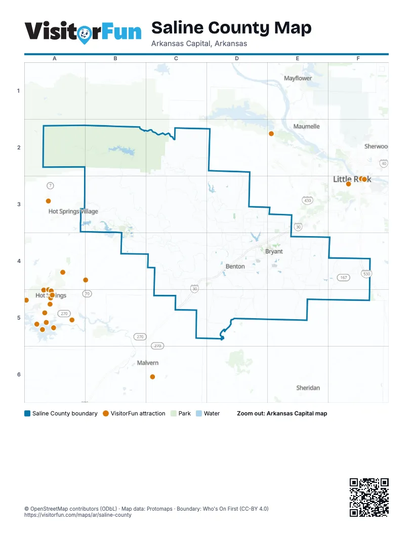
Maps inside Saline County
2 maps inside, from the street map of Saline County down.
Street index of Saline County
Each street on the sheet and the grid squares it crosses.
- US Highway 67C4, D4, C5
- Military RoadD4
- East Grand AvenueC4
- Old Military RoadC5
- East Carpenter StreetD4
- Browning AvenueD4
- I-30 Frontage RoadE3, C4, D4, E4
- Old Hot Springs HighwayB4, C4, D4
- State Highway 9C2, C3, C4
- Highway 298C3, D3, D4
- DeSoto BoulevardA3, B3, B4
- State Highway 35D4, D5
- Congo RoadD3, D4
- Alcoa RoadD4
- South Alexander RoadE4
- Arch Street PikeF4
- Friendship RoadD5
- Boone RoadD4, E4
- Stagecoach RoadE3, E4
- Benton ParkwayD4
- Edison AvenueD4
- South Reynolds RoadE4
- Bauxite HighwayD4, E4
- North Reynolds RoadE4
- West Main StreetD4, C5, D5
- West South StreetD4
- Hot Springs HighwayC4
- AR-5D4, E4
- South East StreetD4
- Longhills Road EastD4
- Alcoa BoulevardD4
- North Main StreetD4
- North Market StreetD4
- North Alexander RoadE3, E4
- South Main StreetD4
- Commerce StreetD4, E4
- Lonsdale Cutoff RoadC4
- West Conway StreetD4
- North East StreetD4
- West Carpenter StreetD4
- West Commerce StreetE4
- Arch StreetD4, F4
- South Street EastD4
- Leander StreetD4
- East Ashley StreetD4
- Lincoln RoadD4
- Geyer Springs RoadF4
- Weyerhaeuser 24000 RoadB2, C2, A3, B3
- Congo-Ferndale RoadD2, D3
- Chicot RoadE4
- 12th StreetC2, D2
- Steelbridge RoadC3, D3
- North Sardis RoadE4
- West Sardis RoadE4
- Bryant ParkwayE3, E4
- Danville RoadB3
- South Sardis RoadE4, E5
- Fairplay RoadC4, C5
- Springhill RoadD3, D4
- Balearic RoadA3, B3
- Childress RoadE4, E5
- Bauxite Cutoff RoadD4, E4, D5
- East Sardis RoadE4, F4
- Grand AvenueD5
- Samples RoadD3, D4
- Vimy Ridge RoadE4
- Hilldale RoadD3, E3
- Brazil RoadD3, D4
- Lake Norrell RoadD3
- County Line RoadB3, D3, C4, E4
- Zuber RoadD3
- Mulberry Salem RoadD4
- North Springlake RoadF4
- East Woodson Lateral RoadF4
- Mount Olive RoadE4
- Minorca RoadB3
- Point View RoadC4, C5
- Salem RoadD4
- Germania RoadE4
- River Ridge RoadC2, D4
- Avilla WestD3
- Springdale RoadD3
- Snow LaneD3
- Pawnee DriveC4, D4
- Mills Park RoadE4
- Hilltop RoadD3, E3
- CrossroadsC4, C5
- Balboa RoadB3
- Salt Creek RoadD4
- Silica Heights RoadD4
- Worth Avenue EastD3, D4
- Kruse LoopD3
- East Fairview RoadE4, E5
- Midland RoadE3
- Shaw Bridge RoadD5
- South Shobe RoadE3, E4
- Northlake RoadD3
- Sparks RoadD3
- Scott Salem RoadD4
- River StreetD4
- East Polk RoadE4
- Styles RoadE4
- East Lawson RoadD3
- North Detonti RoadD4, D5
- Cynamide RoadD4, E4
- Chambers RoadE4
- Kling RoadE4
- South Market StreetD4
- Townsend RoadC4
- Northshore DriveD4
- Avilla Vincintage RoadD3
- McGee RoadD4
- School DriveD4, E4, D5
- Airlane DriveD4
- Sidell RoadD4
- Longhills Road WestD4
- Raney RoadD3
- Shenandoah RoadD4
- Newcomb RoadC4, C5
- Gattin RoadD4
- East Colonel Glenn RoadD3
- West Sevier StreetD4
- Cortez RoadA3, B3
- Coronado DriveA3, B3
- Reed StreetD4
- Woodland Park RoadD4
- East North StreetD4
- Green RoadE4, F4
- Mount Carmel RoadD4
- Boswell RoadD4, E4
- Shobe RoadE4
- Prange RoadD3
- Heinke RoadE4
- Maple Creek RoadF4
- Eastend RoadF4
- Atwood RoadE4, F4
- West Woodson Lateral RoadF4
- West Baseline RoadE3
- Johnswood RoadE4
- Brookwood RoadE4
- Sleepy Village RoadD4
- Prickett RoadD4, E4
- Hart RoadD3, D4
- Avilla EastD3
- Raymar RoadE4
- Sardis RoadE4
- Woodland DriveD4, E4
- Hill Farm RoadE4
- Waterfall WayD4
- Smithers DriveD4
- Wilkerson RoadE4
- Racetrack RoadD3
- East Sevier StreetD4
- North Border StreetD4
- Hoover StreetD4
- Pine Haven RoadD4, E4
- North Summit RoadD4
- Ferguson DriveD4
- South Richard StreetD4
- Asturias DriveA3
- North Aaronfield RoadD4
- Market Place AvenueE4
- North Shady LaneD4
- ElmD5
- Woodard RoadC4
- Shady TrailD4
- FernwoodD4
- Fernwood StreetD4
- North 4th StreetD4
- Balboa DriveB3
- Lora DriveE4
- Pine StreetD4, D5
- Ponce de Leon RoadB3
- Pleasant Hill RoadE4
- North Prickett RoadD4
- South Border StreetD4
- South 4th StreetD4
- Stewart StreetD4
- 2nd Street OverpassD4
- Kidd LaneD4
- Sullivan DriveE4
- Monterrey RoadA3
- Canterbury StreetD4
- Mary Kay BoulevardD4
- North Monroe StreetD5
- Office Park DriveE4
- Bryant Crossing DriveE4
- Haskell DriveC5
- South Monroe StreetD5
- Bell StreetD4
- East Main Haul RoadA3
- Balearic DriveB3
- East Shenandoah RoadD4
- CherryD5
- Woodson Lateral RoadF4
- Traskwood RoadC5
- Brittenum RoadE4
- Willow Springs RoadF4
- Mount Ida RoadB2, C2, B3
- Sulpher Springs RoadB3, C3
- Mars Hill RoadE4, D5, E5
- Narrows RoadC4
- Johnson HighwayB3, C3
- Rushing RoadD2, D3
- Buffalo RoadB2, C2
- Road 23100B3
- North Cold Springs RoadC2, C3
- Nickel Bill James RoadC4
- Upper Ridge RoadC4
- Lake Winona RoadA2, B2, C2
- Mount Olive Cutoff RoadE4
- Davis Wells RoadC3, C4
- Vance RoadB3, C3, B4
- FR 179B2
- Wildman TrailC2
- Rice RoadB3
- Mountain View RoadC4, D4
- Dyer TrailC3
- Hensley Mail Route RoadF5
- CC RoadB3, C3
- Timber Access RoadE5
- Unity RoadC3
- Ira Williams RoadC4
- Burk RoadB3, B4
- Goose Pond RoadB3, B4
- Sioux TrailE4
- Jarandilla DriveB3
- Peeler Bend RoadD4
- Bauxite Pump RoadD4, D5
- South Detonti RoadD5
- Goodwin RoadD3
- South Cold Springs RoadC2, D2
- South Springlake RoadF4, F5
- North Lake Norrell DriveD3
- Holy Ridge RoadC5
- Hollowell TrailC2, C3, D3
- Joe Johnson RoadC2, C3
- Ziegler RoadB3, B4, C4
- Lorance DriveF4
- Kentucky TrailC3, C4
- Y TrailC3
- Long RoadF4, F5
- Ponce de Leon DriveB3
- Sullivan RoadE4
- Thomas Loop RoadC3
- West Jackman TrailC4, D4
- Stone RoadF5
- Holly Creek RoadD5
- West Brook RoadB3
- Pool RoadC4
- West Lawson RoadD3
- Oklahoma End RoadC5
- South Neeley StreetD4
- Maderas DriveB3, B4
- Gunter LoopC3
- Elcano DriveB3, B4
- Grape TrailC3, D3
- Whippoorwill LaneE4
- Taylor TrailE5
- Malone TrailB3
- ReeseE5
- Drake TrailE4, E5, F5
- Jay Creek DriveF4, F5
- Quapaw TrailC4
- Pleasant Run RoadC4
- Cedar Creek RoadB2, B3
- River RoadD4
- Wolf Hollow RoadC2
- Weyerhousen Highway Spur 24490B3
- Harris RoadC4
- West Colonel Glenn RoadD3
- Hood RoadE4, E5
- Lancaster LoopD3
- Bertha MIne Pit RoadE4, E5
- South Reform Road 600B2
- Skyline DriveD3, D4, E4
- Cash Mountain RoadC4, C5
- Detonti RoadD5
- Opitz RoadD5
- Sawdust TrailF4, F5
- Philis DriveF4
- Rock City RoadC2
- Hicks RoadD4, E4
- Reform RoadB2
- Thompson Dairy RoadD3
- Westley Chapel RoadB3
- Smithers RoadC2
- Salvatierra WayB3
- Carl Moren RoadE4, F4
- Pamplona WayB3
- Owensville CutoffB4
- Villacarreido DriveB3
- Montanoso WayA3, B3
- Weyerhaeuser 24220B3
- West Sawmill RoadE4, F4
- Vine StreetD4, E4, C5, D5
- Buffington RoadC4, C5
- Lancaster RoadC3, D3
- Oilwell RoadC5, D5
- Graham RoadC5, D5
Places on the map
- Alcoa Exchange
- Alexander
- Alexander Mountain
- Aloca 40 Park
- Angling Pinnacle
- Ashley HomeStore
- Bauxite
- Benton
- Bryant
- Charles and Norma Bishop Park
- Coronado Golf Course
- Diamante Country Club
- East End
- Flatside Wilderness
- Forest Hills Memorial Park
- Granada Golf Course
- Haskell
- Hester Lake
- Hickory Square
- Hurricane Lake
- Isabella Golf Course
- JJ's Truck Stop
- King Lake
- Lake Balboa
- Lake Coronado
- Lake Cortez
- Lake Lago
- Lake Norrell
- Lake Winona
- Mary Lake
- Mills Park Walkway
- Pebble Lake
- Pinecrest Memorial Park
- Ponce de Leon Golf Course
- Salem
- Saline Memorial Hospital
- Shannon Hills
- Sunset Lake
- Traskwood
- Wilbur Mills Park
Next to Saline County
© OpenStreetMap contributors, Open Database License, openstreetmap.org/copyright · Map data: Protomaps · Boundary: Who's On First (CC-BY 4.0); Quattroshapes (CC BY 2.0)















