

Arkansas map
Bentonville map
About 61,791 people live here (Census Bureau, 2024 estimate). The sheet's index lists 300 streets; Southwest Regional Airport Boulevard, Southeast 5th Street and South Walton Boulevard cross the most grid squares. Things to do inside the boundary: Crystal Bridges Museum of American Art, Scott Family Amazeum and The Walmart Museum.
Open the map (PDF, US Letter)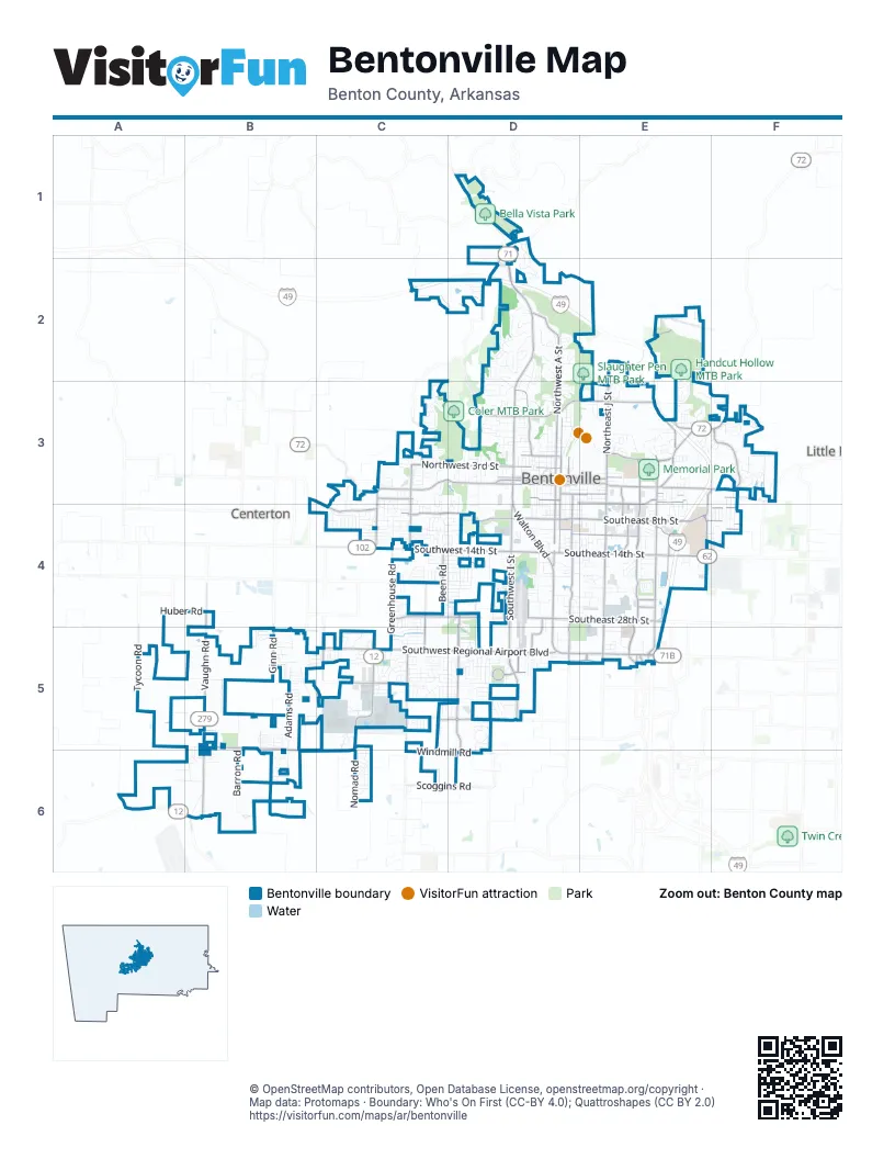
Street index of Bentonville
Each street on the sheet and the grid squares it crosses.
- Bella Vista BypassC2, D2
- Southwest Regional Airport BoulevardB5, C5, D5, B6, C6
- Southwest I StreetD4, D5
- North Walton BoulevardD2, D3
- South Walton BoulevardD3, D4, D5
- Southeast 14th StreetD4, E4
- Southwest 14th StreetC4, D4
- Southeast Walton BoulevardD5, E5
- Northwest Tiger BoulevardD3
- Bella Vista WayD1, D2
- Integrity DriveE3, E4
- East Centerton BoulevardC4
- Northwest 12th StreetD3
- Southeast Walton Boulevard Moberly Turn LaneE5
- Southeast 8th StreetD4, E4, F4
- East Central AvenueD3, E3, F3
- Southwest 8th StreetC4, D4
- Southwest 2nd StreetC3, D3
- Southeast J StreetE3, E4, E5
- Southeast 28th StreetD4, E4
- Southwest H StreetD5, D6
- Southeast Medical Center ParkwayE4, E5
- South Vaughn RoadB5
- West Central AvenueD3
- North Vaughn RoadB4, B5
- West State Highway 72C3
- State Highway 72F3
- 8th & Water Tower Traffic CircleE4
- Southeast Moberly LaneE3, E4, E5
- Southwest Bright RoadD4, D5, D6
- Northwest A StreetD2, D3
- Northeast J StreetE2, E3
- Southeast C StreetD3, D4, D5
- Northwest 3rd StreetC3, D3
- Southwest 28th StreetC4, D4
- Southeast 5th StreetD3, E3, E4, F4
- Southeast Martin Luther King Jr ParkwayE3, E4
- Water Tower RoadE3, F3, E4
- Northeast Tiger BoulevardD3, E3
- Southeast 10th StreetD4, E4, F4
- Northeast John Deshields BoulevardE3
- Southwest Gator BoulevardC5, D5
- Northeast Woods Creek RoadF3
- Southwest A StreetD3, D4
- Peach Orchard RoadD1, D2, C3
- South Main StreetD3, D4, B5
- Bella Vista RoadD3
- McCollum DriveE3
- Southeast 3rd StreetD3, E3, F3
- West Rainbow Farm RoadC5
- Southeast S StreetE4
- Been RoadC4
- Southwest 4th StreetC3, D3
- Greenhouse RoadC4, C5
- East Battlefield BoulevardE3, F3
- North Main StreetD3
- Northwest 2nd StreetD3
- Northeast 2nd StreetD3, E3
- Southwest Elm Tree RoadC3, C4
- Southwest Tater Black RoadC3, C4
- Shell RoadC5
- Town Vu RoadC4
- Ginn RoadB5
- Glen RoadC4
- South Morning Star RoadC5
- North Rainbow Farm RoadC5
- Phyllis StreetE4
- Southeast Plaza AvenueD5, E5
- Southwest Municipal DriveD4, D5
- Northwest 5th StreetD3
- Northeast Moberly LaneE3
- Southwest Citizens CircleD5
- Associate DriveE3, E4
- North Morning Star RoadC5
- Brookside RoadB5
- Southwest 41st StreetD5
- Northeast Martin Luther King Jr ParkwayE3
- Scoggins RoadC6, D6
- Northeast 11th StreetE3
- Little Flock DriveF3
- Northwest Elm Tree RoadC3
- North Tycoon RoadA5
- Southeast David Glass Technology DriveE4
- Southwest Featherston RoadC4, C5
- Northeast B StreetD3
- Punkin Hollow RoadD3
- Southwest Aviation StreetD4
- Southeast Members PlaceE4
- Southeast Simple Savings DriveE4
- Southeast 2nd StreetD3
- Featherston RoadC5
- South Rainbow RoadD5
- Southeast Metro ParkwayE5
- Elk RoadD5
- Southeast Dodson RoadE5
- Southeast Riviera RoadE5
- Bright & 28th CircleD4
- Bright-Maple Traffic CircleD4
- South Dodson RoadE5
- Moberly & John DeShields CircleE3
- West McNelly RoadD1
- Regional AvenueB6
- Horsebarn RoadE5
- Southwest 28th StreethD4
- Moberly LaneE5
- Barron RoadB5, B6
- Northeast A StreetE2, D3, E3
- Motley RoadA5, B5
- Southwest D StreetD3, D4
- Southwest Opal RoadB5, C5
- Anglin RoadB5
- Southeast 18th StreetD4, E4
- Southeast 22nd StreetD4, E4
- Tunbridge DriveC3, C4
- Southwest 10th StreetC4, D4
- Northwest J StreetD3
- Adams RoadB5, B6
- Northeast Grammercy RoadE2, E3
- Stonehenge DriveD2
- Windmill RoadC6, D6
- Southwest Maple RoadD4, D5
- Price Coffee RoadE2
- Southeast 6th StreetD4, E4, F4
- Southwest Edinburgh AvenueD5
- Southwest Vendor BoulevardC5
- Southwest 18th StreetC4, D4
- Northwest 7th StreetD3
- Southwest Nottingham AvenueC5, D5
- Southeast G StreetE3, E4
- Vaughn RoadA5, B5
- Southwest F StreetD3, D4, D5
- Lee Harris RoadB6
- Northwest K StreetD3
- Northwest D StreetD3
- Southeast B StreetD3, D4
- Northwest Riverbend RoadD1, D2
- Nomad RoadC6
- Southwest E StreetD3, D4
- Southwest Fieldstone BoulevardC4
- Northwest 6th StreetC3, D3
- Southeast 21st StreetE4
- Southwest 16th StreetC4, D4
- Southwest Liberty AvenueD5
- Southwest Chestnut Hill RoadC6
- Copper Ridge RoadF3
- Southwest 20th StreetC4, D4
- Southwest B StreetD3, D4
- Northwest 9th StreetD3
- Northwest Angel Falls RoadC3
- Meadowbrook CircleF4
- Southwest Chalkstone RoadC6
- Southwest Deerfield BoulevardC5
- Southwest Hollowbrook StreetD5
- Northeast Memorial Park SquareE3
- Northwest C StreetD3
- Northwest B StreetD3
- Red Fox RidgeD2
- Northwest 10th StreetD3
- Northwest Park Hill RoadC3
- Ridgefield StreetD2, D3
- Southwest Hayfield AvenueD5
- Southeast D StreetD3, D4
- Oakwood AvenueD2, D3
- Mill Dam RoadC6
- Southwest Firefly RoadB5
- Southeast 4th StreetD3, E3
- Melissa DriveD4
- Northwest 11th StreetD3
- Glenbrook AvenueE3
- Northwest O StreetD3
- Northwest Linebarger LaneD2
- Northeast Chapel Hill DriveE3
- Southeast 7th StreetD4, E4, F4
- Southeast E StreetE3, E4
- Northwest Harvard WalkD2
- Southwest Old Farm BoulevardB6
- Museum WayE3
- Southeast John Rollow DriveE4, E5
- Southwest Briar Creek AvenueC5
- Palisades CircleC3
- Northwest Turner DriveD2
- Southwest C StreetD3, D4
- Southeast A StreetD3, D4
- Huber RoadB4
- Southwest Cornerstone RoadC5
- Northwest Creekstone BoulevardD1, D2
- Southwest Carriageway AvenueC4
- Southwest Town Vu RoadC4
- Southwest Juniper AvenueC5, D5
- Somerset StreetD3
- SW Elington StreetD4
- Lyndal LaneE3, E4
- Northeast McClain RoadE3
- Northeast Marina DriveF3
- South Tycoon RoadA5
- Beau Terre DriveE3
- Southeast F StreetE3, E4
- Southwest Hampton AvenueC5
- Southeast Fullerton StreetF3, F4
- Southeast Eaton StreetF3, F4
- Southeast Hendrix StreetF3, F4
- Holly DriveD3
- Paradise WayE3, E4
- Southwest Westpark DriveD4
- Southwest O StreetD3, D4
- Southeast 12th StreetD4, E4
- Southwest Joshua AvenueC5
- Southeast 34th StreetD5, E5
- Southwest Fairview BoulevardB5
- Northeast Buckingham BoulevardE3
- Southeast Eagle WayE4
- Southwest Pinoak AvenueC5, D5
- Southeast Otis Corley DriveE4
- Southwest Buckeye AvenueC5
- Southwest 17th StreetC4, D4
- Southwest Gibson AvenueC4
- Southwest Huntwick AvenueC4, D4
- Southwest Artillery RoadA6, B6
- Southwest Flagstone BoulevardC5
- Southwest Limestone AvenueC4
- Mayflower RoadD4
- Southwest Banbury DriveD5
- Southwest Bison StreetB5
- Northeast Oaktrace AvenueE3, F3
- Southwest Warberry AvenueC4
- Southwest Fir AvenueD5
- Southwest Mallet RoadB5, B6
- Southwest 24th StreetD4
- Convair StreetE4
- Southwest Warrington RoadC6
- East Ford Springs RoadD2, E2
- Northeast 3rd StreetD3, E3
- Trails End DriveE3
- Northeast Kensington AvenueF3
- Northwest Avignon WayD2
- Blueberry LaneE3
- Southwest Autumn Hills RoadC3, C4
- Wildcat WayE3
- Northeast Steinbeck DriveE2, E3
- Benton Ridge CircleF3
- Southwest Orchard WayC3
- Northwest 8th StreetD3
- Southeast H StreetE3, E4
- Southeast Jayhawk BoulevardD4, E4
- Northwest Hermanus StreetC3
- Southwest Mistletoe AvenueC5
- Cardinal Creek CircleD2
- Southwest Layton RoadC5
- Northeast 10th StreetE3
- Northwest Princeton SquareD2
- Southwest Gemstone BoulevardC5
- Southwest 12th StreetD4
- Southwest Summerbrook StreetD5
- Northwest Leopard LaneD3
- Southwest Staverton DriveD5
- Southwest Raintree LaneD4
- Southwest Stone BoulevardD5
- Northwest Wishing Springs RoadD1, D2
- Northwest G StreetD3
- Northeast Brave LaneE3
- Southwest Cabriolet StreetC4
- Southwest Montana AvenueC4, D4
- Valley View CircleD2
- McClain RoadE3
- Southeast P StreetE4
- Southwest 3rd StreetD3
- Southwest Barron RoadB5
- Southwest Blaire Mont RoadD5
- Southwest Lilly StreetC5
- Southwest Plumley AvenueC5
- Southwest Glen Arbor AvenueD5
- Cheryl CircleC4, D4
- Robinhood RoadD3
- Northeast Chaucer StreetE3
- Southwest 6th StreetD4
- Southeast Benton StreetD4
- Southwest Rutland RoadB6
- Northeast Blue Spruce AvenueF3
- Copperfield RoadD2
- Crescent StreetE3
- Southeast Sunrise StreetE4
- Southwest Regency ParkwayD4, D5
- Southwest Wheatgrass BoulevardC5
- Southwest 5th StreetD3, D4
- Southwest Whitmarsh RoadC6
- Southwest Windrift AvenueC5
- Southwest Barn Valley RoadC3, C4
- Southwest Wentworth AvenueC5
- Southeast Falcon LaneE4
- Southwest Golden Eagle AvenueC5
- Quail Run CircleD3
- Southwest Abelia AvenueB5
- Respect DriveE4
- Crestview DriveD3
- Northeast Dysart WoodsE3
- Southeast Club BoulevardE4
- Southwest Modern WayD5
- Southwest Glover AvenueD3, D4
- Northeast Monroe StreetD3
- Southeast 17th StreetD4, E4
Things to do on the Bentonville map
Places on the map
- 21c Museum Hotel Bentonville
- 8th & Plate
- 8th Street Market
- Applegate Event Space
- Bella Vista Park
- Benton Country Fair Grounds
- Bentonville Cemetery
- Bentonville Medical Center
- Bentonville Tiger Stadium
- Citizens Park
- Compton Gardens
- Cornerstone Ridge Park
- Creekside Park
- Creekside Trail Corridor
- Elm Tree MTB Trail L2
- Handcut Hollow MTB Park
- Jackson Lake
- Lake Bentonville
- Lor-Axe
- Lowe's
- Memorial Park
- Orchards Park
- Osage Park
- Park Springs Park
- Pauline Whitaker Library
- Phillips Park
- Razorback Greenway Bentonville South
- Rob's Trail East
- Saint Stephen Catholic Church
- Skills Park at Slaughter Pen
- Slaughter Pen MTB Park
- Sugar Creek
- Sugar Creek Soccer Park
- TAC
- Thaden School
- The Links at Bentonville
- Walmart Home Office
- Walmart Supercenter
- Walton Whole Health & Fitness
- Wolf Park
Next to Bentonville
- Centerton
- Little Flock
© OpenStreetMap contributors, Open Database License, openstreetmap.org/copyright · Map data: Protomaps · Boundary: Who's On First (CC-BY 4.0); Quattroshapes (CC BY 2.0)