

Arkansas map
Bryant map
About 22,271 people live here (Census Bureau, 2024 estimate). The sheet's index lists 300 streets; I-30 Frontage Road, Bryant Parkway and Stagecoach Road cross the most grid squares. Also on it: Alcoa Exchange, Charles and Norma Bishop Park and Mills Park Walkway.
Open the map (PDF, US Letter)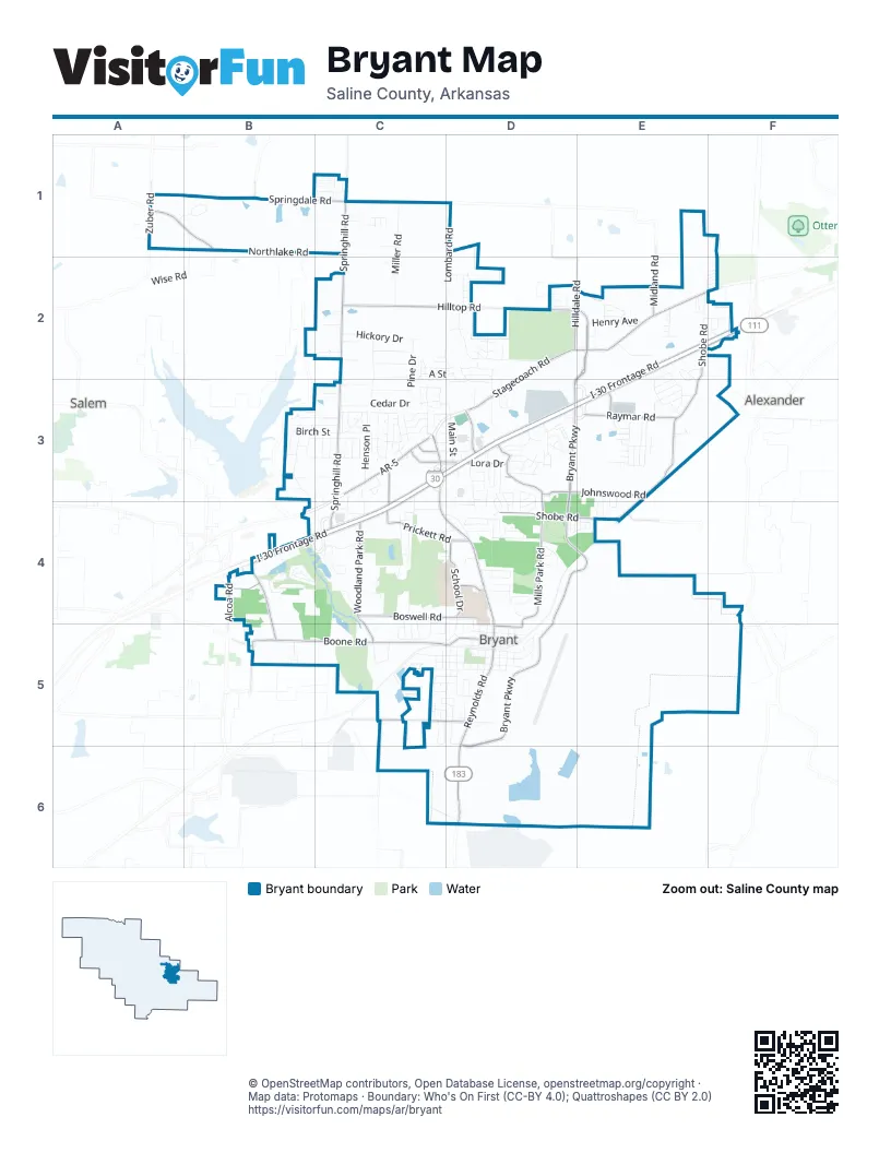
Street index of Bryant
Each street on the sheet and the grid squares it crosses.
- I-30 Frontage RoadE2, F2, C3, D3, E3, B4, C4
- Stagecoach RoadD2, E2, F2, D3
- Boone RoadB5, C5, D5
- North Reynolds RoadC3, C4, D4, D5
- South Reynolds RoadD5, D6
- AR-5C3
- Alcoa RoadB4
- West Commerce StreetC3
- Commerce StreetC3, D3
- Bryant ParkwayE2, D3, E3, D4, E4, D5
- Springhill RoadC1, C2, C3, C4
- Mills Park RoadD3, D4, D5
- Hilltop RoadC2, D2
- South Shobe RoadE2, E3, E4
- Northlake RoadA1, B1, C1
- Woodland Park RoadC4, C5
- Boswell RoadC4, D4
- Shobe RoadD4, E4
- Hilldale RoadC1, D2, E2
- Mount Carmel RoadB4, B5
- Johnswood RoadD3, E3
- Prickett RoadC4, D4
- Raymar RoadE3
- Springdale RoadB1, C1
- Hill Farm RoadD5, D6
- School DriveD4
- Wilkerson RoadC5, D5
- Market Place AvenueD3
- Zuber RoadA1
- Lora DriveD3
- North Prickett RoadC3, C4
- Midland RoadE2
- Sullivan DriveD4
- Office Park DriveC3
- Bryant Crossing DriveE3
- Shady TrailB5
- Cynamide RoadC5
- Woodland DriveD4
- Brookwood RoadE4
- Brittenum RoadE3
- Woody DriveD2
- Southwest 2nd StreetC5, D5
- Miller RoadC1, C2
- Lombard RoadD1, D2
- Cedar DriveC3
- Stivers BoulevardB3, C3
- Green Valley DriveC2, D2, D5
- Commonwealth DriveC2, C3
- Hickory DriveC2
- Southwest 4th StreetC5, D5
- Whirlwind StreetB4
- Henson PlaceC3
- Robinwood CircleC3
- Front DriveC2, C3
- Pine DriveC2, C3
- Northwest 4th StreetC4, C5, D5
- Shoal RoadC4
- Henry AvenueE2
- Crain DriveC5, D5
- Cherry Creek CircleD4, E4
- Millbrook DriveE2, E3
- Southwest 3rd StreetC5, D5
- Forest DriveC3
- Carywood DriveD3, D4
- Allyson AvenueD5
- Stillman LoopC3
- Pleasant Pointe CircleC5
- Bridie LaneC4
- Oak Glenn LoopD2
- Richland Park LoopD3
- Andrew DriveC3
- Birch StreetB3, C3
- Ward DriveB3, C3
- North Shobe RoadE2
- LacrosseE3
- Hurricane Lake RoadB3, B4
- Rodeo DriveC4
- Southeast 1st StreetD5
- Longmeadow DriveE3
- Meadowlake DriveE3
- Ruth DriveD4
- Hurricane DriveB4
- Ridgecrest RoadD3, D4
- West Meadowbrook StreetB3, C3
- Southeast 2nd StreetD5
- Main StreetD3
- Hanover DriveE2, E3
- Timber Creek DriveE3
- Debswood DriveD4
- Brandon RoadC3, C4
- Lexington Park CircleE2, E3
- Laverne StreetD3, D4
- Arcadia CircleD4
- Hickory Creek CircleB1
- Evans LoopC4, D4
- Pinnacle DriveD2, D3
- Wise RoadB1
- Neal StreetD4
- Remington DriveC1
- Monticello West DriveC3, D3
- Oak AcresC2
- Bishop DriveC3, C4
- Rich StreetD5
- Independence CircleC3
- Mulberry AcresC2
- North Richardson PlaceC4
- Aspen AcresC3
- Sheaff AvenueC4
- Maple AcresC2
- Hornet WayD4, D5
- Quapaw DriveD3
- Tanglewood DriveC5, D5
- Corral CircleD3
- Leslie DriveE2
- Raintree DriveD3, D4
- Bridgewater RoadE3
- Bryant AvenueC3, D3
- Prospect Park CircleB5
- Bivens LoopE2
- Cyclone StreetB4, C4
- Grant DriveD2
- Southeast 3rd StreetD5
- Indian Springs DriveD3
- Arbors CircleD3
- Dell DriveC4, D4
- Wedgewood DriveB1
- Bristol DriveD4
- Finley LoopC1
- A StreetC2, D2
- Buckingham PlaceE2
- Johnswood Village DriveE3, E4
- Springhill Village DriveC1
- White Blossom CircleD4
- South Elm StreetD5
- Bridge Port LaneD2
- Anna DriveE2, F2
- Miller Place DriveC4
- Dearborn CircleC3, D3
- Holly Lynn DriveD4
- B StreetC2, D2
- Providence DriveC3
- Northeast 3rd StreetD5
- Bradley StreetD4
- Justus LoopC3
- Pattywood DriveD3, D4
- Shady Pine StreetC3, C4
- Dogwood Place DriveD4
- Northeast 1st StreetD5
- Caldwell DriveB4
- Natalie DriveE2
- Travis ParkwayC3
- Amy CircleC5, D5
- Flintstone DriveD3
- Horizon DriveC3, D3
- South Richardson PlaceC5
- William LaneE2, F2
- Brookside DriveD2
- Robbins DriveD3
- Aberdeen DriveC2
- North Pine StreetD4, D5
- Stoneybrook DriveD2, D3
- Elkhart LoopC5, D5
- Northwest 3rd StreetD5
- Sledgefield DriveC3
- Carmichael RoadC5
- Lori LaneE2
- Kensington DriveC3
- Fieldstone LaneC3, C4
- West Robinhood DriveB3, C3
- Roya LaneC4
- Colonial DriveC3
- Sanders LaneD5
- Logan Ridge DriveD3
- Village Green DriveE3
- Hill RoadD5
- Pleasure DriveC3
- Byron CircleE3, E4
- Vineyard LaneD3
- Southwest 1st StreetD5
- Bass RoadD4
- Ozark DriveC3
- Rogers DriveD4
- Dobbins LaneC4
- Defoe CircleE4
- Hardin DriveC1
- Hurricane Gardens DriveC3
- Todd LaneD4
- Bame CircleD4
- CornerstoneE2, F2
- Edgewood DriveC4
- Derek CourtD2
- Woodstocker DriveE3
- Creekside CoveD2
- Medinah BoulevardC4
- Hunter Lee DriveD3
- Wagner StreetC5, D5
- Vicki DriveC3
- Lynn DriveF2
- Abigail DriveC3
- East Robinhood DriveC3
- West Lea CircleC5
- TomahawkD3
- Bryant Meadows DriveD5
- Tomahawk DriveD3
- Olsen CircleD3
- Lincoln AvenueE2, F2
- East Meadowbrook StreetC3
- North Vine StreetD5
- Northfield DriveE2, E3
- Hunter Lee ParkwayD3
- North Elm StreetD5
- Par DriveC4
- South Fir StreetD5
- Powell DriveC2
- Waterford DriveE3
- Chelsea DriveD3, D4
- South Oak StreetD5
- Coraltree DriveD3, D4
- North Walnut StreetD5
- Northeast 2nd StreetD5
- South Maple StreetD5
- Arrowhead DriveD3
- Meadow Ridge LaneD2
- Greenfield DriveE3
- Canyon WayD2
- Whistling Pine StreetC3
- Christy LaneE2
- Huffman RoadB3
- Maple Park StreetC3
- Glenbrook StreetC3
- Hogue CircleD5
- North HazelD5
- Treetop CoveC4
- South Walnut StreetD5
- Walnut StreetC3
- Whispering Oak StreetC3
- Cedar Park StreetB3, C3
- Griffis RoadD5
- Parkview DriveD4
- Anderson RoadB3
- Hidden Creek DriveC3
- South Hazel StreetD5
- Courtyard Cottages CircleC2, C3
- Anderson Lake RoadB3
- Ethel StreetC4, D4
- Court StreetC2, D2
- Hidden Forest DriveD5
- Magna Carta LaneE2
- South Cherry StreetC5
- East Richardson Place DriveC4, C5
- Summerfield DriveC4, C5
- Wildflower LaneC1
- Hunt RoadC2
- Richwood DriveC4, C5
- Roxbury DriveE3
- Fair Oaks DriveC4, C5
- C D LaneC1
- Courtyard Cottages DriveC2
- Cherokee StreetD3
- Broadway AvenueC3, D3
- Springwood CircleD2
- Darrel DriveC1
- Arey DriveC3
- Moonlighting DriveC3
- Choctaw StreetD3
- Apache DriveD3
- Harvest DriveC3, D3
- Able LaneD3
- Baldwin DriveC2
- Garden Club DriveD3
- Madison StreetF2
- Glenn Hill DriveD1
- Flametree DriveD4
- Pine CircleC3
- Hunter Wood DriveC5
- Park DriveD4
- Hickory Creek DriveA1, B1
- Morningside DriveC5
- Price AvenueC3
- ShadowcreekE3
- Corporate Center DriveE2, E3
- Davis DriveC3
- Martin LaneD5
- Southeast 4th StreetD5
- Foxglove DriveE4
- Ramond LaneC1
- Sunset Meadows DriveC3
- East Lea CircleC5
- Ashlea Place DriveC3
- Hawley RoadB3
- Wood Forest DriveD2
- Meadow Creek DriveE2
- Double Eagle WayC4
- McClanahan DriveD3
- Center StreetD3
- Juvenile Center RoadD2
- North Laurel StreetD5
- Lynne CourtE2
- South Laurel StreetD5
- Oak Glenn CourtD2
Places on the map
- Abundant Life Church
- Alcoa Exchange
- Aloca 40 Park
- America's Car-Mart
- Americas Best Value Inn & Suites Bryant Little Rock
- Arkansas Federal Credit Union
- Arvest Bank
- Ashley HomeStore
- Ashley Park
- AutoZone
- Big Red
- Boswell Municipal Center
- Bryant Branch Saline County Public Library
- Bryant Cemetery
- Bryant Parkway
- Bryant Stadium
- Caldwell Lake
- Centennial Bank
- Charles and Norma Bishop Park
- Circle K
- Civitan Shoppe
- Comfort Inn & Suites Bryant - Benton
- Country Inn & Suites
- Courtyard Cottages Circle
- Cracker Barrel
- Crush Wine & Spirits
- CVS Pharmacy
- Dollar General
- Dollar Tree
- Econo Lodge
- Exxon
- First Baptist Church
- First Security Bank
- Mabel Boswell Memorial Library
- Mills Park Walkway
- Pinecrest Memorial Park
- Raymar Fields
- Saline County Regional Airport
- United States Post Office
- Wilbur Mills Park
Next to Bryant
- Alexander
- Salem
© OpenStreetMap contributors, Open Database License, openstreetmap.org/copyright · Map data: Protomaps · Boundary: Who's On First (CC-BY 4.0); Quattroshapes (CC BY 2.0)















