

Arkansas map
Carroll County map
About 28,968 people live here (Census Bureau, 2024 estimate). The sheet's index lists 300 streets; East Van Buren, State Highway 23 and State Highway 187 cross the most grid squares. Things to do inside the boundary: Thorncrown Chapel, Turpentine Creek Wildlife Refuge and Blue Spring Heritage Center.
Open the map (PDF, US Letter)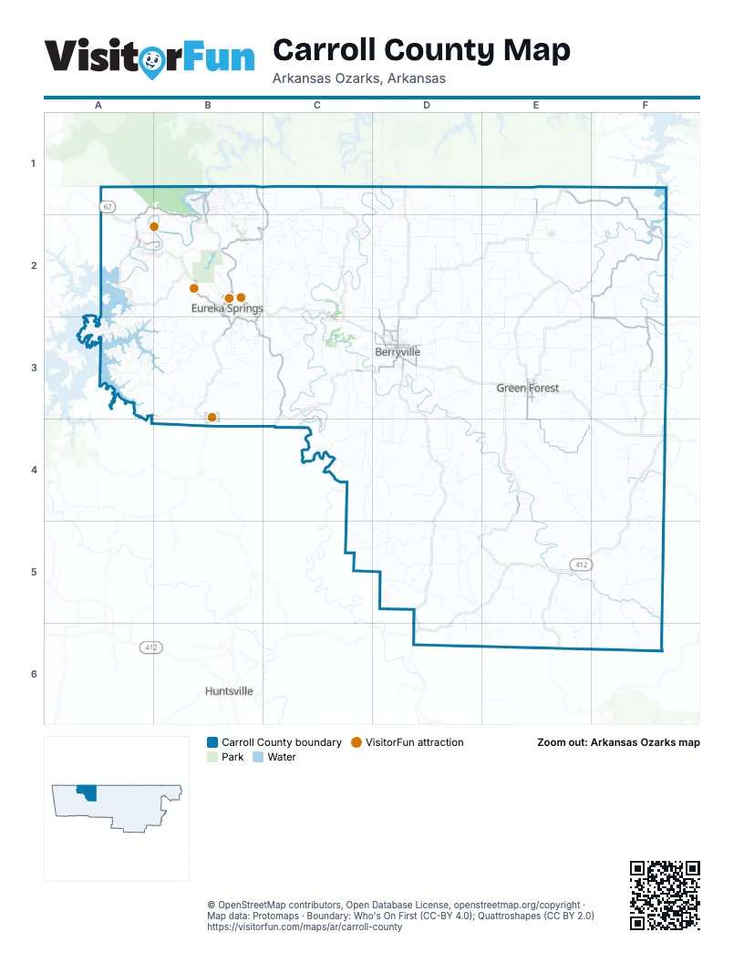
Street index of Carroll County
Each street on the sheet and the grid squares it crosses.
- East Van BurenB2, C2, B3, C3
- West Van BurenB2
- South Main StreetB2, D3
- North Springfield StreetD3
- West Freeman AvenueD3
- North Main StreetB2, D3
- East Main StreetE3
- West Main StreetE3
- West Trimble AvenueD3
- East Freeman AvenueD3
- East Van Buren StreetB2, B3
- Huntsville RoadB3
- Eureka AvenueD3
- West Van Buren StreetB2
- South Springfield StreetD3
- Van Buren StreetB3
- Kings HighwayB2
- West Freeman StreetD3
- State Highway 23B1, C1, B2, C2
- State Highway 187A1, B1, A2, B2
- Huntsville StreetC3, D3
- Mc Kennon Ford RoadD3
- Lark DriveE4
- County Road 435E1
- Main StreetB1, B2
- High StreetD3
- North Springfield AvenueE3
- West Carl AvenueD3
- Beaver BridgeB2
- Golden GateB2
- State Highway 311F2, F3
- County Road 302B3, C3, C4
- South Springfield AvenueE3, E4
- Highway 311E1, F1, F2
- County Road 814F3, F4
- County Road 811F3
- Woodsdale DriveB1, B2
- County Road 402D2, D3
- East College AvenueD3
- Spring StreetB2, D3
- County Road 212A2, B2
- Passion Play RoadB2, B3
- County Road 846F3
- Hailey RoadD3
- Magnetic DriveB2
- Shields DriveB1
- Trinnen LaneD3
- Grand AvenueB2
- South Arch AvenueE3
- Cherry StreetD3, E3
- County Road 109A2
- North Carroll AvenueE3
- Oak View DriveD3
- County Road 173A2
- East 10th StreetE3
- Mountain StreetB2
- Prospect AvenueB2
- Crescent DriveB2
- Ellis Grade StreetB2
- North AvenueD3
- White StreetB2
- Ojo StreetB2
- SpringB2
- WashingtonB2
- Summit StreetB2
- West Hill StreetF4
- Denver RoadF3
- County Road 905E4, E5, F5
- County Road 422D2, E2
- County Road 501D3, C4, D4
- County Road 614E2, F2
- County Road 933E5, F5
- County Road 705D3, E3, D4, E4
- County Road 518D4, D5
- Brady Creek RoadC4, D4
- County Road 808E3, F3
- Buck Mountain RoadA3, B3
- County Road 516C5, D5
- County Road 207C2
- County Road 403D2
- County Road 152A3
- County Road 506D3, D4
- County Road 425D1, D2
- County Road 436E1, E2
- County Road 608D2, D3
- County Road 959E5, E6
- County Road 717D4, E4
- County Road 219C1, C2
- County Road 523C4
- Mundell RoadA2, A3
- County Road 647E2, E3
- County Road 507C3, C4
- County Road 601D3, E3
- County Road 830F3
- County Road 720D5, E5
- County Road 939E5, E6
- County Road 702D3
- County Road 818F2
- County Road 613E3
- County Road 973F5
- County Road 306C2, C3
- County Road 982F5, F6
- County Road 226C1, C2
- County Road 102B3
- County Road 411C2, D2
- County Road 728D5
- County Road 645D2, E2
- County Road 972F5, F6
- County Road 641E2, D3, E3
- County Road 504D3, D4
- County Road 420D2
- County Road 116B2, A3, B3
- County Road 621E2, E3
- Stateline DriveB1
- County Road 708D3
- County Road 220B2, C2
- County Road 505C3, D3
- County Road 139B3
- County Road 636E2, F2
- County Road 921F4, F5
- Holiday Island DriveB1, B2
- County Road 810E3, F3
- County Road 524D5
- County Road 607D3, E3
- County Road 824F2
- County Road 620E1, E2
- County Road 317B3
- County Road 150A3
- County Road 329C3
- County Road 327C3
- County Road 610E2
- County Road 625E2, F2
- County Road 719D5
- County Road 114A3, B3
- County Road 156A3
- County Road 739D4, E4
- County Road 825F3
- County Road 452C1, D1
- County Road 638E2
- Wild Turkey DriveB1, B2
- County Road 711D3, D4
- County Road 433E1, E2
- County Road 216C2
- County Road 612E2
- County Road 938E3, E4
- County Road 418C1, D3
- Pivot Rock RoadB2
- County Road 834C3, F3
- County Road 733D4, E4, D5
- County Road 211C2
- County Road 535C4
- County Road 822F2
- County Road 309C2, C3
- County Road 239C2
- County Road 821F3, F4
- HogscaldA3, B3
- County Road 723D5
- County Road 222B2
- County Road 715D4
- County Road 510D4
- County Road 405D2
- County Road 550D5
- County Road 603D3
- County Road 246C2
- Bluebird LaneB3
- County Road 514D5
- County Road 630F1, F2
- Parker StreetE3
- County Road 449D1, D2
- County Road 266B2
- County Road 428C2, D2
- County Road 919F4
- County Road 943D5, E5, E6
- County Road 734D5
- County Road 322C3
- County Road 323B3, C3
- County Road 663F1
- County Road 978F4, F5
- County Road 311 NorthE3
- County Road 957E5, E6
- County Road 667F1, F2
- County Road 912F4
- Table Rock DriveB1
- County Road 545C4, C5, D5
- Valley DriveB1, B2
- County Road 136A2
- County Road 2264C1, C2
- County Road 816F2, F3
- County Road 409D2
- Bunch Springs RoadC3, D3
- County Road 465D1, D2
- Mill Hollow RoadB2, B3
- County Road 966F4
- View Point DriveA3
- County Road 118A2, B2
- County Road 993E4
- County Road 802E3, F3
- County Road 961E5, E6
- County Road 602D2
- County Road 671E2
- County Road 208B2
- Oaks Landing DriveB1
- County Road 617E3
- County Road 812F3
- County Road 541C4, C5
- County Road 815F3, F4
- State Line RoadE1
- County Road 644E2
- County Road 827E3, F3
- County Road 450C1, D1, D2
- Starlite AvenueB1
- County Road 677E3
- County Road 628E1, E2, F2
- County Road 803E3, F3
- County Road 445D2, E2
- County Road 819F3
- County Road 606D2
- Glisson Hollow RoadD5
- Hawk DriveB1, B2
- County Road 623E2, E3
- County Road 5252C4
- County Road 232A1
- Lakeshore RoadA3
- County Road 731D4
- County Road 427D2, E2
- County Road 447E1, D2, E2
- Eagle Cove RoadA3
- County Road 204B2
- County Road 115B2, B3
- County Road 238C2
- County Road 455C2, D3
- County Road 210B2
- County Road 107A2
- County Road 209C2
- County Road 1531A3
- County Road 837F3
- County Road 544D5
- County Road 548C5, D5
- Bandy DriveB1
- County Road 414C2
- County Road 716E4
- County Road 224C2
- County Road 947D5, D6
- County Road 903E3
- County Road 525C4
- County Road 2332B1, B2
- Edgewater RoadA3
- County Road 155A3
- Valhalla DriveC2
- County Road 650F2
- Rhodes DriveB3
- Sisco RoadD3
- County Road 917F4
- County Road 142B3
- County Road 228C1
- Summit DriveB1
- County Road 231B2
- County Road 111A2
- County Road 462D2
- Sailboat DriveB1
- County Road 832E3, F3
- County Road 401D2, D3
- Beaver DriveB1
- County Road 515D3, D4
- Aspen RoadD4
- County Road 426C3, D3
- County Road 432C2
- County Road 844F3
- Nightingale RoadB2, E5
- County Road 2462C2
- County Road 987E6
- County Road 1390B3
- County Road 616E2
- Country Club DriveB2, C3
- County Road 970E4, F4
- Sunrise AvenueB1
- Dupps LaneA2
- Clark RoadD3
- County Road 635D3
- County Road 153A3
- County Road 942E4, F4
- County Road 513D3
- County Road 925F5
- Lakeshore DriveA3
- County Road 443D1, D2
- County Road 8302F3
- County Road 3402B3
- County Road 233B1, B2
- County Road 829E3
- North Bayshore DriveA2
- County Road 964F4
- County Road 543C4, C5
- County Road 710E3
- Wolf RidgeB2
- Hillside AvenueB1, B2
- County Road 230B1, C1
- County Road 953E5
- Chestnut RoadE5
- County Road 9782F4, F5
- RedwoodF1
Things to do on the Carroll County map
Places on the map
- Alpena
- Anderson Mountain
- Ant Mountain
- Aviation Cadet World
- Beauty Is Everywhere
- Beaver
- Beaver Lake Dive Park
- Bench Loop Trail
- Berryville
- Berryville Memorial Cemetery
- Berryville Public Library
- Black Bass Lake
- Black Mountain
- Blacklick Mountain
- Blue Eye
- Boat Mountain
- Bradshaw Mountain
- Brewer Lake
- Brother Knobs
- Brush Mountain
- Brushy Knobs
- Brushy Mountain
- Buck Mountain
- Buck Mountain Airport
- Busch Post Office
- Carroll County Airport
- Chinkapin Mountain
- Eureka Springs
- Eureka Springs KOA Journey
- Farwell Spider Creek Lake
- Green Forest
- Hammer Field
- Holiday Island Country Club
- Lake Leatherwood
- Lake Leatherwood Park
- Oak Grove
- Revelation
- Silver Wings Field
- Turpentine Creek Wildlife Refuge
- Woodland
Next to Carroll County
- Huntsville
© OpenStreetMap contributors, Open Database License, openstreetmap.org/copyright · Map data: Protomaps · Boundary: Who's On First (CC-BY 4.0); Quattroshapes (CC BY 2.0)















