

Arkansas map
Jefferson County map
About 63,672 people live here (Census Bureau, 2024 estimate). The sheet's index lists 300 streets; Nctr Road, Highway 530 and South Olive Street cross the most grid squares. Things to do inside the boundary: Arkansas Land of Legends and Arts and Science Center for Southeast Arkansas.
Open the map (PDF, US Letter)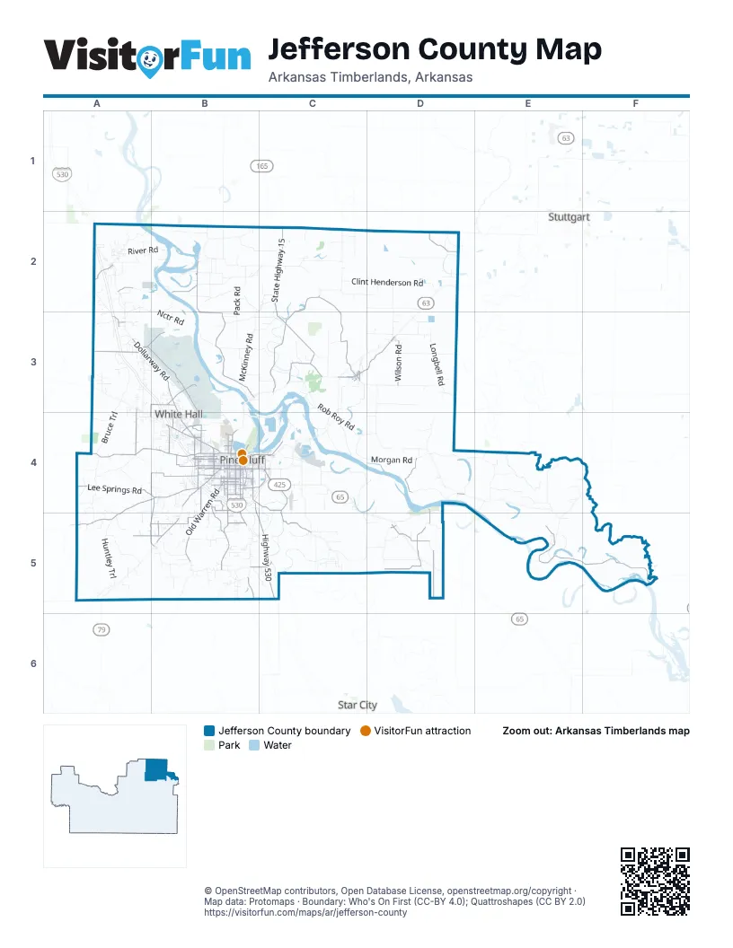
Maps inside Jefferson County
1 map inside, from the street map of Jefferson County down.
Street index of Jefferson County
Each street on the sheet and the grid squares it crosses.
- Wiley A. Branton Senior HighwayB4, C4
- Martha Mitchell ExpresswayB4, C4
- Highway 530B4, B5, C5
- South Camden RoadB4, B5
- South Olive StreetC3, B4, B5
- Sheridan RoadA2, B4
- South Main StreetB4
- East Harding AvenueB4, C4
- University DriveB4
- East 8th AvenueB4, C4
- South Blake StreetB4
- West Front StreetC3
- South Florida StreetB4
- Convention Center DriveB4
- West Harding AvenueB4
- Front StreetC3, D3, B4
- North Blake StreetB4
- North 1st StreetD3
- East Front StreetC3
- State Highway 15C2, C3
- Dollarway RoadA3, B3, B4
- Sulphur Springs RoadA4, B4, A5
- State Highway 31C2, C3
- Princeton PikeA4, B4
- Old Warren RoadB4, B5
- South Hazel StreetB4, B5
- West 13th AvenueB4
- West 6th AvenueC3, B4
- State Highway 13D2
- West 17th AvenueB4
- South Cherry StreetB4
- Jefferson ParkwayB4
- West 16th AvenueB4
- West 28th AvenueB4
- West Barraque StreetB4
- West 5th AvenueB4
- Glendale RoadC4, B5
- West Holland AvenueA3, B3
- West 27th AvenueB4
- West 31st AvenueB4
- East 6th AvenueB4, C4
- East 5th AvenueB4
- South Ohio StreetB4
- Miramar DriveB4
- Main StreetC3
- West Hoadley RoadB3
- Market StreetC4
- South EdlineC3
- East Main StreetC3
- North Cherry StreetB4
- North University DriveB4
- Bayou Meto Recreation RoadD4, E5, F5
- Earl Chadick RoadB2, B3
- Cantrell RoadC2, C3
- Lee Springs RoadA4, B4
- Middle Warren RoadB4, B5
- Griderfield-Ladd RoadC4, C5
- Wilbur West RoadB4, C4
- Shannon RoadB4, D5
- West Clemmons RoadD5
- Camden Cutoff RoadB4, A5, B5
- Sibert RoadB3
- Tamo River RoadD4, D5
- Hardin-Reed RoadA3, A4
- Wilson RoadD3
- Bond RoadA3, B3, D5
- Blue Rock RoadC3, D3
- Port RoadB4, C4
- Sorrells RoadB5
- West 34th AvenueB4
- Oakwood RoadB4
- Ridgway RoadB4
- East 38th AvenueB4, C4
- Klie RoadD5
- West Bitely RoadD5
- Roemer RoadA3, B3
- South Fir StreetB4
- West 8th AvenueB4
- Dyson RoadA5, B5
- North Hutchinson StreetB4
- Claud RoadB4
- South Georgia StreetB4
- Lock and Dam Number 5 RoadB2
- Ryburn RoadB4
- Junet RoadA3
- Gravel Pit RoadA3
- Pinebergen RoadB5, C5
- Spring Lake RoadA5, B5
- West Pullen StreetB4
- South Quattlebaum RoadC3
- Petty RoadA4, B4
- South Catalpa StreetB4
- West Short 3rd AvenueB4
- East 2nd AvenueB4, C4
- North Bryant StreetB4
- North Spruce StreetB4
- South Walnut StreetB4
- South Bay StreetB4
- West Quattlebaum RoadC3
- West 73rd AvenueB5
- Newton RoadD5
- White Bluff RoadA2
- Moscow Store RoadD5
- Industrial Drive SouthB4
- Country Club LaneB4
- South Cypress StreetB4
- Faucett RoadB4
- Cross RoadB5
- Bobo RoadB4
- Chandler RoadA3
- Commerce RoadC4
- Robin RoadB4
- East Hoadley RoadB3
- Monk RoadA3, A4
- Hoadley RoadB3
- Rhinehart RoadB4
- G Rice RoadC2
- South Wisconsin StreetB4
- Division StreetD2
- Regional Park DriveB4
- South Franklin StreetB4
- Boys School RoadB4
- Oliver RoadB4
- West 39th AvenueB4
- Fluker StreetB4
- East 28th AvenueB4
- White Hall AvenueB4
- South Division StreetC3
- East 2nd StreetC3
- Hampton ParkwayB4
- List DriveB3
- Cheatham StreetB4
- West Stagecoach RoadA3
- East 27th AvenueB4
- Jefferson Lincoln Cnty Line RoadC5
- South Bryant StreetB4
- South Michigan StreetC4
- Watson Boulevard SouthB4
- North Division StreetC3
- East BarraqueB4
- 2nd StreetC3
- Stark Gate RoadA3
- Blue RockC3
- Grant 18A5
- North Walnut StreetB4
- Pine Bluff ArsenalA3, B3
- Cornerstone RoadD4, E4
- Morgan RoadC4, D4
- Patrol RoadA3, B3
- Rob Roy RoadC3, C4
- State Farm RoadC2
- Swan Lake RoadD4
- Joe T Henslee RoadB2, C2, B3
- River RoadA2, B2
- Longbell RoadD3
- Providence RoadA4, A5
- Nctr RoadA2, B2, A3, B3
- South McKinney RoadB3
- Gibb-Anderson RoadC5
- North Gilliand RoadD2, C3, D3
- Mulberry Grove RoadD3
- McCoy RoadB3
- German Springs RoadA3
- Paper Mill RoadC4
- Bruce TrailA3, A4
- Atkins Lake RoadC4, D4
- Mitchell RoadB3, C3
- Huntley TrailA5
- Blankenship RoadD4, D5
- North Pack RoadB2, B3
- Reed Lake RoadC3, C4
- Stagecoach RoadA2, A3
- Nolan RoadD4
- Lab RoadA5
- West Clint Henderson RoadC2, D2
- Horseshoe Lake RoadB3, C3
- Ferda RoadB2, C2
- Wrape RoadE4
- Chaney RoadA2
- Summers RoadA4
- Burgess RoadC2
- Blackwell RoadC3
- McFadden RoadB3, B4
- East Clint Henderson RoadD2
- Luckie RoadE5
- Abernathy RoadC5, D5
- West 15th AvenueB4
- Morrow RoadB2
- East Altheimer RoadD3
- Island Harbor Marina RoadC3, B4, C4
- South Mulberry StreetD2, B4, B5
- West 4th AvenueB4
- Sell Davis RoadB2
- Knott Island RoadC4
- Lateral BD3
- Reydell RoadE4
- West 2nd AvenueB4
- Old Star City RoadB5, C5
- Hooker RoadC5
- Guenther RoadB3, C3
- Townsend RoadC5, D5
- Bennett RoadB2
- West 14th AvenueB4
- Wintergreen RoadB3
- Collier Lee RoadC3
- West 11th AvenueB4
- McEntire RoadC5
- Sheppard Island RoadC4
- Joe T Hensley RoadB2
- West 12th AvenueB4
- Garrett RoadD3
- Jefferson Lincoln County Line RoadC5
- Walker RoadC2, D2
- West 7th AvenueB4
- Hannaberry Lake RoadE5
- South Poplar StreetB4
- South Linden StreetB4
- South Beech StreetB4, B5
- Florene Chadick RoadE4
- South Elm StreetB4
- Crooked Creek RoadD2
- Marshall LaneD2
- Gaddy Koonce RoadB5
- Dierk Mills RoadB4
- Webster RoadB3, A4
- South Evans RoadB4
- Whiteville RoadB5
- West 3rd AvenueB4
- South Hickory StreetD2, B4
- Old Tram RoadA4
- Atkisson RoadB3
- West 10th AvenueB4
- Stokes RoadA3, B3, A4
- West 9th AvenueB4
- North McKinney RoadB2, C2, B3
- Wheeler Chapel RoadC5
- East Pointer RoadC5
- Noble Lake RoadC4
- East Jim Ford RoadB3, C3
- Hanlon RoadA3, B3
- West Hartley Dump RoadD2
- West Hartley RoadD2
- Mabry RoadD5
- South Missouri StreetB4
- Hudson Cemetery RoadA5
- South Laurel StreetB4, B5
- Brinkley RoadB4, B5
- Brunetti RoadC3, D3
- Williams RoadB3, C3
- Ray Dean RoadB2
- Wabbaseka RoadD2, D3
- Bartlett RoadB2, B3
- Fish Lake RoadB3
- Richmond Core RoadB2, C2
- Wabbeseka RoadD2
- Divoky RoadB5
- Kearney RoadA2
- South Plum StreetB4
- Dudley RoadC2
- Cottonwood Church RoadC3
- Celia RoadC4
- South Ash StreetC3, B4
- Potpourri RoadC5
- Brown Cemetary RoadB5
- South Oak StreetB4, B5
- West 25th AvenueB4
- South Cedar StreetB4
- South Apple StreetB4
- West 26th AvenueB4
- Swan LakeD4
- West 18th AvenueB4
- Wampler Spur RoadA4
- South Indiana StreetB4
- South Pine StreetC3, B4
- Charles Wooden RoadC4
- South Pack RoadB3
- West 29th AvenueB4
- Jeter RoadD3
- Wolfe RoadA2
- South Tennessee StreetB4
- Crossett RoadA4
- West 30th AvenueB4
- West Altheimer RoadD3
- Refuge RoadA5
- Maynard RoadB2
- Wise RoadB3
- Pipkin-Glover RoadB3
- West 36th AvenueB4
- Wood RoadB2
- Watkins RoadB2
- Reynolds RoadA2
- Fairfield RoadC4
- South Locust StreetB4
- Tar Camp Creek RoadB2
- West 19th AvenueB4
- West 24th AvenueB4
- Kings Bayou RoadD4
- Louis L Ramsay RoadC4
- South Gilliand RoadC3, D3
- South Holly StreetB4
Things to do on the Jefferson County map
Places on the map
- Altheimer
- Barbara Ester Unit
- Bellwood Cemetery
- Bennett Landing Strip
- Correction Circle
- Doman Lumber
- Emmett Sanders Lock
- Forest Lawn Memorial Cemetery
- Grider Field
- Harbor Oaks Golf Club
- Jaycee Golf Course
- Lake Saracen
- Martin Luther King Jr. Park
- Memorial Park Cemetery
- Midland Lake
- National Center for Toxicological Research
- Pine Bluff
- Pine Bluff Arsenal
- Pine Bluff High School
- Pine Bluff Regional Park
- Redfield
- Redfield City Park
- Reed Lake
- Rising Star Park
- Rust Lake Number One
- Sainte Marie Park
- Saracen Casino Resort
- Sheppard Island Public Use Area
- Sherrill
- Swan Lake
- The Pines
- Tommy's Flying Service
- Trulock Park
- Tucker Unit
- Tulley Lake
- U.S. Army Corps of Engineers
- UAPB Farm
- Wabbaseka
- White Hall
- WIlkins Lake
Next to Jefferson County
- Star City
- Stuttgart
© OpenStreetMap contributors, Open Database License, openstreetmap.org/copyright · Map data: Protomaps · Boundary: Who's On First (CC-BY 4.0); Quattroshapes (CC BY 2.0)















