

Arkansas map
Pine Bluff map
About 38,785 people live here (Census Bureau, 2024 estimate). The sheet's index lists 300 streets; Wiley A. Branton Senior Highway, Martha Mitchell Expressway and South Olive Street cross the most grid squares. Things to do inside the boundary: Arkansas Land of Legends and Arts and Science Center for Southeast Arkansas.
Open the map (PDF, US Letter)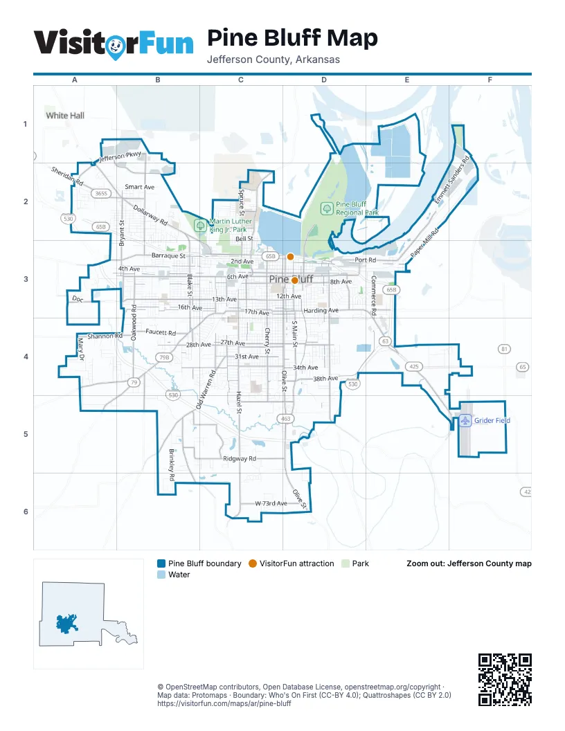
Street index of Pine Bluff
Each street on the sheet and the grid squares it crosses.
- Martha Mitchell ExpresswayA2, B2, B3, C3, D3, E3, E4
- Wiley A. Branton Senior HighwayA2, A3, A4, B4, D4, E4, B5, C5, D5
- South Olive StreetC3, D3, D4, D5, D6
- South Main StreetD3, D4, D5
- East Harding AvenueD3, E3, E4
- South Camden RoadB4, A5
- University DriveC2, C3
- East 8th AvenueD3
- South Blake StreetB3, B4
- South Florida StreetD3, D4, D5
- Convention Center DriveD3
- West Harding AvenueC3, D3
- North Blake StreetB2, B3
- South Hazel StreetC3, C4, C5, C6
- West 13th AvenueA3, B3, C3, D3
- West 6th AvenueA3, B3, C3, D3
- West 17th AvenueB3, C3, D3
- South Cherry StreetC3, C4, C5
- Jefferson ParkwayA1, B1, A2
- West 16th AvenueB3, C3, D3
- West 28th AvenueB4, C4, D4
- West Barraque StreetA3, B3, C3, D3
- Old Warren RoadC4, B5, C5
- West 5th AvenueA3, B3, C3, D3
- Dollarway RoadA2, B2
- West 27th AvenueB4, C4, D4
- West 31st AvenueB4, C4, D4
- East 6th AvenueD3
- Sulphur Springs RoadA4, B4
- Sheridan RoadA2, B2
- East 5th AvenueD3
- South Ohio StreetD3
- Miramar DriveC3, B4, C4
- Princeton PikeA3
- Market StreetE3
- North Cherry StreetC3
- North University DriveC3
- Port RoadE2, D3, E3
- West 34th AvenueB4, C4, D4
- Oakwood RoadB3, B4
- Wilbur West RoadD3, D4, D5
- Ridgway RoadB5, C5, D5
- East 38th AvenueD4, E4
- South Fir StreetC3, C4, C5
- West 8th AvenueB3, C3, D3
- North Hutchinson StreetB1, B2, B3
- South Georgia StreetD3, D4
- West Pullen StreetC3, D3
- Griderfield-Ladd RoadE4, E5, F5
- Middle Warren RoadB5, B6
- South Catalpa StreetC3, C4
- West Short 3rd AvenueB3, C3
- East 2nd AvenueD3, E3
- North Bryant StreetB2, B3
- North Spruce StreetC2, C3
- South Walnut StreetD3, D4
- South Bay StreetB3, B4
- West 73rd AvenueC6, D6
- Shannon RoadA4, B4
- Industrial Drive SouthA1, A2, B2
- Country Club LaneC5, D5
- South Cypress StreetC3, C4
- Faucett RoadB4
- Bobo RoadB5, C5
- Commerce RoadE3, E4
- Ryburn RoadB4, B5
- Rhinehart RoadB2, C3
- South Wisconsin StreetD3
- Regional Park DriveD2, D3
- South Franklin StreetB3
- West 39th AvenueC4, D4
- Fluker StreetC2
- East 28th AvenueD4
- Hampton ParkwayC5
- Cheatham StreetB2
- East 27th AvenueD4
- Oliver RoadC2
- South Bryant StreetB3
- South Michigan StreetD3
- Watson Boulevard SouthC2
- East BarraqueD3
- North Walnut StreetD3
- West 15th AvenueB3, C3, D3
- West 4th AvenueA3, B3, C3, D3
- South Mulberry StreetC3, C4, C5, C6
- West 2nd AvenueB3, C3, D3
- West 14th AvenueB3, C3, D3
- West 11th AvenueB3, C3, D3
- West 12th AvenueB3, C3, D3
- West 7th AvenueA3, B3, C3, D3
- South Poplar StreetC3, C4, C5
- South Linden StreetC3, C4
- South Beech StreetC3, C4, C5, C6
- South Elm StreetC3, C4, C5
- West 3rd AvenueB3, C3, D3
- West 10th AvenueB3, C3, D3
- South Hickory StreetC3, C4
- West 9th AvenueB3, C3, D3
- South Missouri StreetD3, D4
- South Laurel StreetC3, C4, C6
- South Plum StreetC3, C4, C5
- South Ash StreetC3, C4
- South Oak StreetC3, C4, C6
- West 25th AvenueB4, C4, D4
- South Cedar StreetC3, C4, C5
- South Apple StreetB3, B4
- West 26th AvenueC4, D4
- West 18th AvenueB3, C3, D3
- South Indiana StreetD3, D4
- West 29th AvenueC4, D4
- South Tennessee StreetD3, D4
- West 30th AvenueB4, C4, D4
- South Pine StreetD3, D4
- West 36th AvenueC4, D4
- South Locust StreetC3, C4
- West 19th AvenueB3, C3, C4, D4
- West 24th AvenueC4, D4
- South Holly StreetC3, C4
- West 33rd AvenueC4, D4
- Emmett Sanders RoadF1, E2, F2
- West 20th AvenueB4, C4, D4
- Harbor Oaks DriveD2
- West 32nd AvenueB4, C4, D4
- West Hepburn StreetB3, C3
- East 10th AvenueD3, E3
- South Maple StreetC3, C4
- Brinkley RoadB5, B6
- West 40th AvenueC4
- Pines Mall DriveE3, E4
- South Taft StreetB3, B4
- South Chestnut StreetD3, D4
- South Virginia StreetD3, D4
- West 35th AvenueB4, C4, D4
- East 4th AvenueD3, E3
- West 37th AvenueC4, D4
- South Juniper StreetB3, C3, C4
- West Short 4th AvenueB3
- South State StreetD3, D4
- Right Frontage RoadD4, E4
- South Pennsylvania StreetD3, D4
- South Dakota StreetD3, D4
- South Persimmon StreetB3, B4
- Beachfront DriveD2
- South Spruce StreetC3, C4
- South Louisiana StreetD3, D4
- West Jones StreetA2, B2
- South Grant StreetB3
- South Lee StreetB3, B4
- South Hemlock StreetB3, B4
- South Orange StreetC3, C4
- East 3rd AvenueD3, E3
- South Alabama StreetD3, D4
- East 17th AvenueD3
- South Peach StreetB3
- West 23rd AvenueC4, D4
- South Nebraska StreetD3, D4
- South Pear StreetB3
- South Kentucky StreetD3, D4
- West 21st AvenueB4, C4, D4
- South Bois D Arc StreetB3
- North Willow StreetC2, C3
- Belmoor AvenueD3, E3
- Riverside DriveD1
- Good Faith RoadB5
- West 22nd AvenueC4, D4
- South Willow StreetC3, C4
- South Gum StreetC3, C4
- North Magnolia StreetC2, C3
- South Utah StreetD3, D4
- North Haley StreetB2, B3
- Bullock StreetA2, B2
- East 30th AvenueD4
- North Lane StreetB2
- West 42nd AvenueC4
- South Young StreetB3
- East 11th AvenueD3
- North Norman StreetB2
- South Palm StreetC3, C4
- Correction CircleA3
- North Moreland StreetB2
- South Sycamore StreetC3
- East 7th AvenueD3
- Paper Mill RoadE3
- East 31st AvenueD4
- East 52nd AvenueD5
- North Cypress StreetC2, C3
- Vaugine StreetB3, C3
- South Texas StreetD3, D4
- West Burnett StreetB3
- South Myrtle StreetC3, C4
- Hoover StreetB2
- Belmont DriveD3
- South Magnolia StreetC3, C4
- South Fig StreetB3
- South Oleander StreetB3
- North Birch StreetC2, C3
- Howard DriveC3, C4
- South Birch StreetC3
- Smart AvenueB2
- West Knight StreetB2
- Regional ParkD2
- East 34th AvenueD4
- East 16th AvenueD3
- South Larch StreetC3
- North Palm StreetC2, C3
- Carbon StreetA2, B2
- East 12th AvenueD3
- North Maple StreetC2, C3
- Osborn RoadE4
- Hangar RowF5
- Calhoun StreetA2, B2
- South Gross StreetB3
- North Hazel StreetC2, C3
- Malcomb StreetB2
- North Hickory StreetC2, C3
- Edwards StreetA2
- Oxford DriveA2
- South Richard DriveB3
- King StreetC3
- Townsend Park DriveC2
- DocA3
- West Saracen StreetC3
- Saint Marie Park RoadF1
- Bell StreetC2
- Windham AvenueA2, B2
- West Short 2nd AvenueB3, C3
- LongmeadowC4
- North Pryce StreetB2
- North Spears StreetB2
- East 24th AvenueD4
- Union AvenueB4
- West Mosley StreetA2, B2
- East 13th AvenueD3
- East 43rd AvenueD4, D5
- South Mississippi StreetD3, D4
- Cottonwood CircleB2
- Mary DriveA4
- West Hill StreetC2
- Scenic DriveA4
- Sturgis RoadB2
- West 41st AvenueC4
- East Pullen StreetD3, E3
- South Washington StreetD3
- West Flipper StreetA2, B2
- Wormack StreetA2, B2
- South Dearborn StreetB3
- Island Harbor Marina RoadD1, E1
- Black Dog DriveD2
- Free Line DriveA3
- Chapel Heights DriveA4
- Left Frontage RoadE4
- Mobile StreetE4, F4
- West Short 13th AvenueB3, C3
- School StreetB2, B3
- Reed StreetC2
- East 15th AvenueD3
- South Hutchinson StreetB3
- Reeker StreetC2
- Regional Park CampgroundD2
- Dusty Lake DriveB4
- East 42nd AvenueD4
- East 14th AvenueD3
- Cherokee LaneA2
- West Jeffcoat RoadA4
- East 26th AvenueD4
- East 25th AvenueD4
- Elm Woods CircleC4, C5
- Nevins RoadA5
- West Holsey StreetB2
- South Redbud StreetB3
- Sunset RoadA2, A3, B3
- War Eagle DriveC6
- East 32nd AvenueD4
- Kay Don RoadA4
- West Scull StreetB3, C3
- Roane AvenueC2
- Westgate LaneD3
- East 9th AvenueD3
- East 21st AvenueD4
- South Orlando StreetB4
- Jaycee DriveB2, C2
- Briney RoadA4
- Oakland Park DriveB2, C2, C3
- Park PlaceD3, D4
- Whiteside StreetC2
- Mallard LoopC5, D5
- Oakridge DriveB4
- Short Reeker StreetC2
- West Havis StreetC2
- Sheffield DriveC5
- East Lake DriveB4
- Lake Pine Bluff DriveD3
- Fair Oaks DriveC4
- McRae CircleA3
- North Phillips StreetA2
- Talbot AvenueD4
- West Kennedy StreetB2
- Kenwood DriveB4
- North Richard DriveB2
- Nell DriveA4
Things to do on the Pine Bluff map
Places on the map
- All In One Wholesale
- Arkansas Railroad Museum
- Art Works
- Arts & Science Center for Southeast Arkansas
- Barbara Ester Unit
- Barraque Baptist Church
- Bay Street Baptist Church
- Bellwood Cemetery
- Belmont Park
- Best Western
- Beverage King
- BIG D's EATERY
- Briarwood Inn
- Calvary Cemetery
- Central Park
- Correction Circle
- Doman Lumber
- Graceland Cemetery
- Grider Field
- Harbor Oaks Golf Club
- Jaycee Golf Course
- Jefferson Regional Medical Center
- Lake Saracen
- Lowe's
- Martin Luther King Jr. Park
- Matthews Elementary School
- Memorial Park Cemetery
- Midland Lake
- Miller Cemetery
- Pine Bluff Convention Center
- Pine Bluff High School
- Pine Bluff Regional Park
- Pine Bluff Unit
- Sainte Marie Park
- St. John Alexander Tower
- The Pines
- Torii Hunter Baseball Complex
- Torii Hunter Softball Complex
- Townsend Park
- Walmart Supercenter
Next to Pine Bluff
- White Hall
© OpenStreetMap contributors, Open Database License, openstreetmap.org/copyright · Map data: Protomaps · Boundary: Who's On First (CC-BY 4.0); Quattroshapes (CC BY 2.0)















