

Arkansas map
Sherwood map
About 33,281 people live here (Census Bureau, 2024 estimate). The sheet's index lists 300 streets; State Highway 107, Warden Road and Red River Drive cross the most grid squares. Also on it: Gravel Ridge, Reservior Indian Head Lake and Sherwood Forest.
Open the map (PDF, US Letter)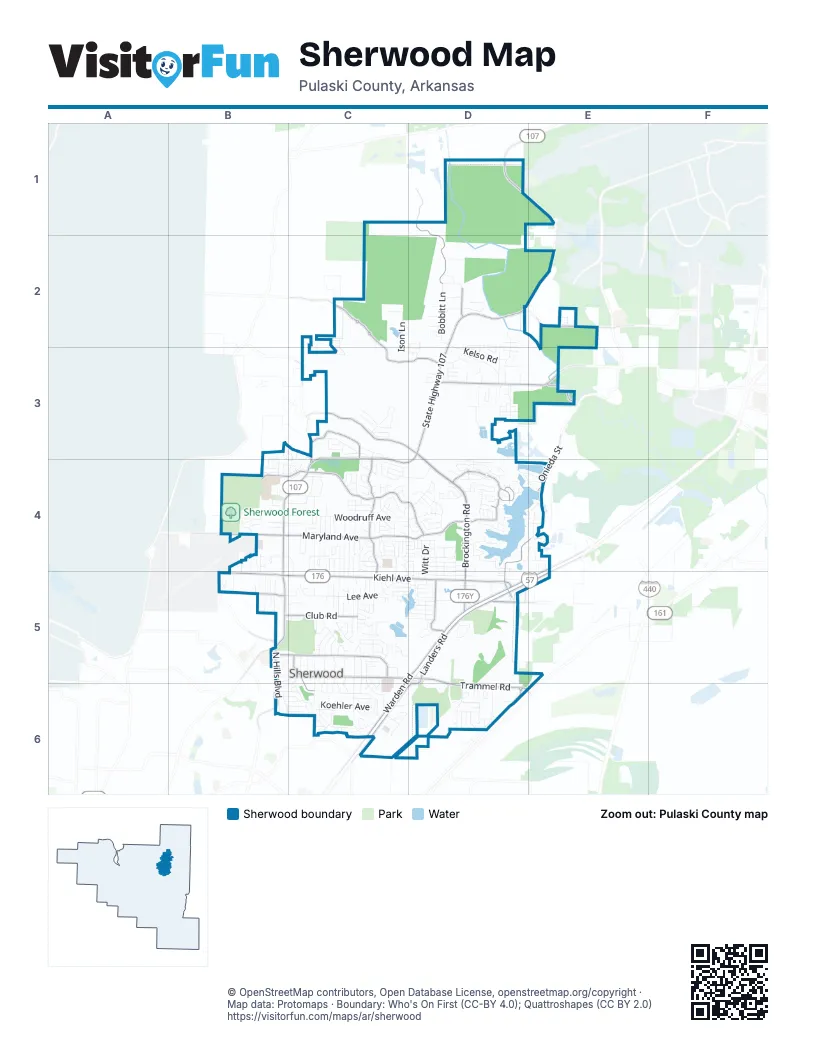
Street index of Sherwood
Each street on the sheet and the grid squares it crosses.
- State Highway 107D1, D2, C3, D3, B4, C4, D4, B5
- East Kiehl AvenueB5, C5, D5
- Indianhead DriveD4, E4, D5
- John F Kennedy BoulevardB5
- State Highway 176D5
- Brockington RoadD3, D4, D5
- Warden RoadE4, C5, D5, E5, C6
- Landers RoadD5, E5, D6
- Jacksonville Cutoff RoadD3, E3
- Trammel RoadD5, D6
- Wildwood AvenueC5, D5
- Frontage RoadC6, D6
- Brookswood RoadD5
- East Maryland AvenueB4, C4, D4
- Jacksonville-Cato RoadC2, C3, D3
- Oakbrooke DriveC3, C4, C5
- Country Club RoadB5, C5
- Johnson DriveC4, D4
- Hatcher RoadD1, D2
- Oak Dale RoadC3, D3
- Gap Creek DriveD4
- Club RoadB5, C5
- Miller RoadC3
- General Samuels RoadE2
- Lantrip RoadD5
- West Maryland AvenueB4
- North Hills BoulevardB5, B6
- Indian Bay DriveD4
- West Kiehl AvenueB5
- Bear Paw RoadB4, C4
- Roundtop DriveD6
- West Lee AvenueB5
- Sherwood AvenueC5, C6
- Glenn Hills DriveD4
- Onieda StreetE4
- Stonehill DriveD4
- Kellogg Acres RoadC3, C4
- Rixie RoadD5
- Rixey RoadD5
- Old Hwy 67D6
- Roundtop RoadD6
- East Woodruff AvenueB4, C4, D4
- East Lee AvenueB5, C5
- Gibson RoadD3
- Shoshoni DriveD4, E4
- Silver Creek DriveC6
- Bobbitt LaneD2
- Ison LaneC2, C3
- South Claremont AvenueC5, C6
- Trammel Estates DriveD6
- Koehler AvenueC6
- Cliffside DriveC4
- Feldspar DriveD4
- Coulter RoadC6
- Seminole TrailB6, C6
- Dee Jay Hudson DriveB4
- Kelso RoadD2, D3
- Thornhill DriveC4
- Alanbrook AvenueC5
- Rapid Water DriveC4, D4
- Hillcrest RoadC4
- Beaconsfield RoadC5, C6
- South Fairway AvenueC5, C6
- Calloway AvenueD4
- Ridgelea AvenueD4, D5
- Coolhurst AvenueC5
- Ridgemist LaneD6
- Pumice DriveC4, D4
- Newman DriveC6
- Autumnbrook CircleC4
- North Valley DriveD2, D3
- Gap Point CircleD4
- East Shore DriveC5, D5
- Red River DriveB5, C5, B6, C6
- Trail Creek DriveC4
- Manson RoadD4, D5
- Oakridge RoadB5
- Greenview CircleC5
- Ridgewell RoadC4, C5
- Overcup DriveC4
- Farris AvenueC4
- Barber StreetC4, C5
- Woodbine DriveC4
- Shadow Oaks DriveC6
- Wesley DriveC4
- Verona AvenueC5, C6
- Pennwood DriveC5
- Witt DriveD4, D5
- Meadow Gardens CircleC3
- Claremont AvenueC4, C5, C6
- Hidden Creek DriveB3, C3, B4, C4
- Shelby RoadC4, C5
- Randall DriveD2, D3
- Devon AvenueC5, C6
- Hickory HeightsC3
- Ascot DriveD4
- Tammy LaneD6
- Holiday DriveC4, C5
- South Longfield AvenueC5, C6
- Willow Grove RoadC4
- Lynnewood DriveD3
- Cherrie AvenueD4
- Bronco LaneC5
- Oak Forest LaneC3
- Bearskin DriveD4
- Lake Tree LaneD4
- Woodruff Creek DriveB4
- Fork River RoadB6, C6
- North Devon AvenueC5
- Chimney Rock DriveB6, C6
- East Ridge DriveD4
- North Claremont AvenueC5
- Maryland PlaceC4
- Briarpatch LaneD3
- Dyson StreetC6
- Austin Bay CourtD4
- Creekwood DriveD3
- Jessica DriveC4
- North Beverly AvenueC5
- Rock Ridge DriveD4
- Patricia Lynn LaneC4, C5
- Millers Glen DriveC3
- Mohave StreetE4
- King PlaceD2, D3
- Cordelia DriveD3
- Miramonte DriveC4
- Pamela LaneC4
- Amanda DriveD3
- Whitewood DriveC4
- Ann AvenueD5
- May StreetD4
- Hillwood DriveB4, C4
- Wilhite LaneC4, C5
- Austin Lakes CircleD4
- Baring Cross RoadD5
- Houston StreetE4
- Cornflower LaneC5
- Looper RoadB4
- Hutton AvenueC5, D5
- Waterview PlaceD4
- Leatherwood LoopD6
- Summitt StreetD5
- North Fairway AvenueC5
- Maelstrom CircleC4
- West Ridge CircleD4
- Oak Heights DriveC3
- Stonehenge DriveD2
- Willow Glen CircleD4
- Windridge DriveB4, C4
- Creekridge CircleD2, D3
- Daniel DriveC5
- Shady Side DriveB4
- Teetwood RoadB4, C4, C5
- Deerfield DriveD4, E4
- West Lake CircleC4
- Oak Forest CircleC3
- Lucy LaneD4, E4
- Greenwood AvenueD5
- Wild Mountain DriveC4
- Spring Grove DriveC4
- King Pine RoadC4
- Cedaridge DriveD3
- Sage Meadows CircleD4
- Creekview DriveC4
- Park Meadows DriveD4
- Stafford RoadC5
- Gap Ridge DriveD4
- Watercrest LoopD6
- Laurel Oaks DriveC3
- White Oak WayD6
- Millers Pointe CourtC3
- Stillwater RoadC4
- Carnelian DriveD4
- Plant RoadD3
- Silver Oak DriveC6
- Narragansett PlaceD4, E4
- Verona CircleC5
- Raywood DriveC4
- Cedar Creek RoadB6
- Plumdale DriveC4, D4
- Wildflower DriveD2, D3
- Austin Harbor DriveD4
- Longstreth StreetD4, D5
- Abercorn PlaceC6
- Rita DriveD3
- Wetherbee CircleC4
- Sheila DriveC2
- Hatcher DriveD2
- Ridgetop DriveB4
- Dogwood LaneC5, D5
- Pineview AvenueD5
- Gap Meadows DriveD4
- North Woodview DriveD5
- Nora LaneD2
- Post Oak LoopC4
- Tenkiller DriveD4
- Meadow Creek DriveC3
- Wooded Acres CircleC4
- Wandering RidgeD2
- Ridgevale RoadD2, D3
- Beverly AvenueC5
- Glenora AvenueC5
- Hemphill StreetD4, D5
- Apple Valley DriveB5, C5
- Austin Gardens CourtD4
- Southshore LaneD4
- Pecan Vally DriveC4, D4
- Little Elm LaneD6
- Elmwood AvenueC5, D5
- Peach Tree LaneC4
- Taylor RoadD3
- Hawkwood RoadC5
- Robin LaneC4
- Getty DriveD5
- Obsidian DriveC4, D4
- Pinto TrailC5
- Merrymen RoadC4, C5
- Patty LaneC4
- Easy StreetB5
- Mark AvenueB5
- Powell DriveC5
- Hamilton Park DriveC4
- Thomas StreetC4, C5
- Delmont AvenueC5
- Katye LaneB4, B5
- Hayley DriveD2
- Johnson AvenueC4
- Sherer DriveD5
- Brice RoadC4
- Eubanks RoadD3
- Hemphill RoadD4
- Denton DriveB4
- Cardinal LaneB4, C4
- Grosvenor DriveC6
- Silverbrook DriveD4
- Pine Oak LaneD6
- Park AvenueC5
- Spring River RoadB6, C6
- Tiffany CircleB4
- Commerce CourtD5
- Hollmore LaneD4
- Fairview AvenueC5
- Gum DriveC5
- Heritage DriveC5
- Karla CircleC6
- Cherrywood DriveD5
- Magnolia WayD6
- Chiliwood LaneB4, B5
- Shady Oak DriveD4
- Wild Rose LoopD6
- Greenhaven PlaceD2, D3
- Oakhaven DriveC4, C5
- Spring RoadD5
- Lagrue DriveB6, C6
- Ridgewood DriveD2
- Willow WayD6
- Creekdale DriveD2, D3
- Cub TrailB3, B4
- Cottonwood AvenueC5, D5
- Jasper DriveD4
- Woodridge DriveD4, D5
- Audubon CoveB4, B5
- Serenade DriveC4
- Brice StreetC4
- Calva RoadC5
- Rock Springs DriveC4
- Almond CoveB5
- Briar StreetD4
- Barbara AvenueD4
- Grandview StreetD4
- Maxine AvenueD4
- Northgate DriveC4, C5
- Elwood DriveD3
- Roberta Ann StreetC6
- Oakleaf LaneC4
- Robin Glen DriveB4
- Summit StreetD4
- Brundle CourtC4
- Harmony DriveC4
- Marble DriveE2
- Illinois Bayou DriveB5, C5
- West Beverly AvenueC5, C6
- Chestnut DriveB4, C4
- Oakwood ManorD2
- Manor DriveC5
- Wilhite AvenueC4
- South Woodview DriveD5
- Adams DriveE2
- Brighton DriveB5
- Wadley RoadC6
- Spring Oak DriveD4
- Indianhead CoveD5
- Roundleaf CourtC6
- Bob O Link LaneC5, D5
- Magnet DriveD5
- Summer Shade LaneC4
- Campden Hill RoadC6
- Corral RoadC5
- Hemlock AvenueD5
- Ingleside DriveC4
Places on the map
- Academy Sports + Outdoors
- Arvest Bank
- At's Imports
- Baring Cross Baptist Church
- Best Western
- Brockington Road Church of the Nazarene
- Brushy Cemetery
- Buffalo Wild Wings
- Capitol Cleaners
- Casey's General Store
- CHI St. Vincent North
- CHI St. Vincent Rehabilitation Hospital - North
- Circle K
- Crain Hyundai of North Little Rock
- CVS Pharmacy
- Dollar General
- Eagle Bank
- Eagle Bank and Trust
- Edgewood
- Extra Closet Self-Storage
- F.L. Davis Ace Hardware
- Fairway Park
- Fellowship Christian Center
- First Arkansas Bank & Trust
- First Christian Church of Sherwood
- Franklin Hill
- Gap Creek Drive
- Grace Church
- Gravel Ridge
- Gravel Ridge Post Office
- Gregory Polaris
- Henson Park
- Holiday Inn Express
- Lake Cherrywood
- Reservior Indian Head Lake
- Rest Hills Cemetery
- Sherwood Forest
- Sylvan Hills Sports Complex
- The Greens at North Hills
- Walmart Supercenter
© OpenStreetMap contributors, Open Database License, openstreetmap.org/copyright · Map data: Protomaps · Boundary: Who's On First (CC-BY 4.0); Quattroshapes (CC BY 2.0)















