

Arizona map
Kingman map
About 35,383 people live here (Census Bureau, 2024 estimate). The sheet's index lists 300 streets; Purple Heart Trail, Stockton Hill Road and East Andy Devine Avenue cross the most grid squares. Things to do inside the boundary: Historic Route 66 Arizona.
Open the map (PDF, US Letter)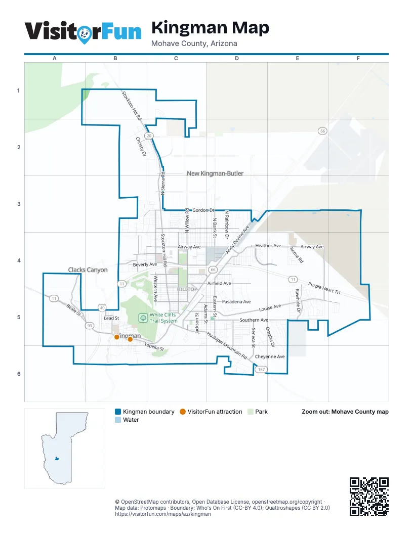
Street index of Kingman
Each street on the sheet and the grid squares it crosses.
- Purple Heart TrailB4, C4, D4, E4, B5, E5, F5, B6
- Stockton Hill RoadB1, B2, C2, C3, C4, C5
- East Andy Devine AvenueD3, C4, D4, B5, C5
- Airway AvenueC4, D4, E4
- West Beale StreetA5, B5
- Hoover Dam–Kingman HighwayA5
- West Andy Devine AvenueB5
- Ella's PlaceB5
- Louise AvenueC5, D5, E5, F5
- Hualapai Mountain RoadC5, D5, D6
- Gordon DriveB3, C3, D3
- Eastern StreetD4, D5
- Western AvenueC3, C4, C5
- Harrison StreetC4, C5
- North Bank StreetD3, D4
- Fort Beale DriveA4, A5, B5
- Flying Fortress ParkwayE4, E5
- North Willow RoadC3, C4
- North Harvard StreetB3, B4
- Sycamore AvenueB4, C4, D4
- East Beale StreetB5, C5
- Grandview AvenueB5
- East Anson Smith RoadB4
- North Castle Rock RoadD3, D4
- Longview AvenueB5
- Turquoise StreetB5
- Northern AvenueC2
- Betty LaneA5
- 10th StreetC5
- West Anson Smith RoadB4
- Southern AvenueC5, D5, E5
- Beverly AvenueB4, C4, D4
- Pasadena AvenueC5, D5
- Airfield AvenueC4, D4
- Kino AvenueC3, D3
- Santa Rosa DriveD4, E4
- North Central StreetD4, D5, D6
- Detroit AvenueC4, D4
- Fairgrounds BoulevardC4, C5
- Railroad StreetC5
- Seneca StreetD5, D6
- Diamond Spur StreetE4, E5
- Jagerson AvenueB2, C2
- North Burbank StreetC4
- Motor AvenueC4
- Townsend StreetD4
- Sunset BoulevardC5
- Armour AvenueC4, D4
- Hoover StreetC4, C5
- Sierra Vista AvenueC3
- College DriveC2
- Detroit StreetC4, D4
- Pacific AvenueC4, D4
- Karen AvenueC5, D5
- Washington StreetD4, D5
- Slaughter House Canyon RoadC5, C6
- North Arizona StreetD3, D4
- North Benton StreetD3, D4
- Morrow AvenueC4, D4
- North Rainbow DriveD3, D4
- Adams StreetC5
- North Prescott StreetD3, D4
- Topeka StreetB5, C5, C6
- North Roosevelt StreetC3, C4
- Sunrise AvenueB4, C4
- Country Club DriveB4, C4, B5
- North Sierra RoadC2, C3
- Gates AvenueB5, C5
- Main StreetC4, C5
- Omaha DriveD5, E5, E6
- Kingman AvenueC4, C5
- North Irving StreetC3, C4
- North Evans StreetD3, D4
- Calumet AvenueC4, D4
- Rawhide DriveE4, E5
- Riata Valley RoadB4, C4
- Pawnee DriveD5, E5, E6
- Peart AvenueC4, D4
- Stephens AvenueC4, D4
- Sunshine DriveD3, D4
- North 4th StreetB3, B4, B5
- North Comanche DriveE5, E6
- Dakota RoadD5, E5
- Cheyenne AvenueD6, E6
- North Lomita StreetC3, C4
- North Bond StreetC3, C4
- North Skylark RoadC3, C4
- Gemstone AvenueE5
- Scotty DriveB2, C2
- Miami AvenueC4
- North Melody StreetD3, D4
- Triangle South StreetE4, E5
- Club AvenueC5
- Davis AvenueC5
- Robinson AvenueC5
- Florence AvenueC5
- Golden Gate AvenueC5
- Lucille AvenueC5
- North Jewell StreetD3, D4
- Cerritos LaneD6
- Simms AvenueC5, D5
- Steinke DriveB2, C2
- Packsaddle RoadD6
- Pinto RoadE5
- Jackson StreetC5
- Chicago AvenueC4
- Yavapai StreetD5, D6
- Mountain Trail RoadE4, E5
- Chambers AvenueC5, D5
- Ashfork AvenueC4, C5
- North Pinal StreetC3, C4
- North Apache StreetD3, D4
- Monroe StreetC5
- Heather AvenueD4, E4
- Phoenix AvenueC5, D5
- Wickieup AvenueC5, D5
- Christy DriveB2, C2
- Delaware DriveD5, D6, E6
- Wilshire AvenueB4, C4
- Lillie AvenueC5, D5
- Marlene AvenueC5, D5
- North Glen RoadC3, C4
- Kenwood AvenueB4, C4, D4
- Harrod AvenueC5, D5
- Mission BoulevardC5, D5
- North Eagle Rock RoadD3, D4
- Broudy DriveD5
- La Salle StreetC4, C5
- Walapai AvenueC5, D5
- Emerson AvenueC5, D5
- West Old Trails RoadB6
- John Wayne DriveC3
- Atlantic AvenueC4, A5
- Rutherford StreetC4
- Franklin DriveD5
- North Adams StreetC3, C4
- East Oak StreetB5
- Roma RoadE4
- Berry AvenueC5, D5
- Isador AvenueD5
- Charleston StreetD4
- Astor AvenueB4, C4
- South 6th StreetB5, B6
- Georgia AvenueC5, D5
- Hope AvenueC4
- Rising Sun AvenueE5
- North Fairfax StreetC4
- Greenway DriveB4
- Camelback BoulevardB2
- Crestwood DriveB3, C3
- Running Iron StreetE5
- North Jerome StreetD4
- Ross AvenueC5, D5
- Fripps Ranch RoadD5, D6
- Mac Donald AvenueC4, D4
- Parkview AvenueB5
- Ellermann DriveD5
- Iroquois DriveE5
- Alan Ladd DriveC3
- North 2nd StreetB4, B5
- Walleck Ranch DriveC3
- Palo Verde DriveB3, C3
- North 5th StreetB4, B5
- Rosslynn DriveD6
- Valentine AvenueC4, C5
- Rhoades AvenueC4, D4
- Rancho Santa Fe ParkwayE5
- Broken Arrow StreetE5
- Hodges RoadB4
- Butler AvenueC2
- Chinook DriveD5
- Pueblo DriveE5
- East Park StreetB5
- North Apache DriveD4, D5
- Yavapai DriveD4, D5
- North Pearl StreetC3, C4
- North Sage StreetD4
- North Cypress StreetD4
- North Miller StreetC3, C4
- Pine StreetB5
- Van Buren StreetC5
- Sage StreetD5
- North Kenneth RoadC3, C4
- Swing StreetC4
- El Rancho DriveB4
- North Moore StreetC3, C4
- Cerbat Vista DriveB3, B4
- North Verdugo RoadC3, C4
- Prospector StreetE4
- North Wells StreetC3, C4
- East Spring StreetB5
- North Prarie View DriveD3
- Superba AvenueC5, D5
- Canyon Hills RoadC3
- Southern Vista DriveD5
- Berk AvenueB4, C4
- Maple StreetB5, C5
- North Diamond StreetD4
- Hillcrest DriveB3, C3
- Martingale DriveC3, B4
- North 1st StreetB5
- Seminole DriveE5
- North Yavapai StreetD4
- Laramie AvenueD5
- Lovin AvenueC5, D5
- Gene Autry DriveC3
- Katie Lane LoopE4
- Amanda AvenueD5
- Brenda AvenueD5
- Cherri AvenueD5
- West Lead StreetB5
- Cantle DriveB3, B4
- Wildflower StreetD5
- Sonora Desert StreetD4
- Monte Moro RoadE4
- Potter AvenueB2, C2
- Rex Allen DriveC3
- East Grace Neal ParkwayC1, B2
- North 3rd StreetB5
- Cherokee StreetE5, E6
- North Stardust RoadC3
- North Van Nuys RoadC3
- North Shadow RoadC3
- Metcalf RoadB5
- Sioux AvenueE5
- Diamond Joe RoadE4
- Colorado AvenueC5, D5
- Monte Silvano AvenueE4
- Shadow Mountain RoadB3, C3
- Glencliff AvenueE5
- South 4th StreetB5, B6
- Bar Boot StreetE5
- Silver StreetB5
- Mustang Springs RoadE5
- Los Angeles StreetC4, C5
- 1st AvenueD5, B6
- Producers Mine RoadD5, D6
- Hidden Canyon RoadE5
- Ricca DriveC4
- Selma DriveB2, C2
- Arnold RoadC2
- Manor DriveC4
- Greystone DriveC3
- Sandstone StreetE5
- Prospect StreetE4
- Shane DriveB2
- Maya DriveD5, D6
- Cimarron DriveE4, E5
- North Essco StreetD4
- North Brook StreetD3, D4
- Roy Rogers WayC3
- Windsor AvenueB4
- Simon AvenueB4
- Buckskin AvenueE5
- White Cliffs RoadB5
- Eagle View RoadC1
- North Yuma StreetD4
- Darren DriveD5
- East Old Trails RoadB6
- Golf DriveC4, C5
- North Tucker StreetD4
- Nelson AvenueC4, D4
- South 5th StreetB5, B6
- Wagon Trail RoadA5
- Golconda AvenueB6
- Pinal StreetC3, C4
- Edgerock AvenueE5
- Whitehead AvenueD5
- Crozier AvenueC4, C5
- Mullen DriveC4
- Copper StreetB5
- Vista Grande DriveB4, C4
- Lyons RoadE4
- Arlington StreetC5
- Peterson RoadC4
- Kit Carson RoadB5
- Will Rogers WayC3
- Broadway AvenueC5
- Latigo LaneB3
- Chestnut StreetB5
- North Alpha StreetD4, D5
- Fire Thorn AvenueE5
- Kingman Crossing BoulevardE4
- Dale Evans WayC3
- Blackfoot DriveE6
- Byrd AvenueD4
- Gold StreetB5
- Steamboat DriveD5
- Lindsey AvenueC3
- Rafter B AvenueE5
- Split Branch DriveD4
- South 2nd StreetB5, B6
- Coronado AvenueC3, D3
- Chadwick DriveC5
- Grace Neal ParkwayC1
- Clay Springs AvenueE4
- Raymond AvenueC3
- West Spring StreetB5
- 4th AvenueD5, B6
- Evelyn DriveB5
Things to do on the Kingman map
Places on the map
- 4R Stables
- Ace Hardware
- Apex Auto Glass & Tint
- Arby's
- ARC of Mohave County
- Arco
- Arizona Department of Public Saftey
- Arizona Inn
- Arizona Route 66 Museum
- AutoZone
- Bashas'
- Beale Celebrations
- Berry Tank
- Best Western Plus a Wayfarer's Inn And Suites
- Best Western Plus King's Inn & Suites
- Black Bear Diner
- Budget Inn
- Burger King
- C-A-L Ranch Stores
- Centennial Park
- Cerbat Cliffs Golf Course (Kingman Municipal)
- Flying J Travel Center
- Hualapai Mountain Campus
- Kingman Middle School
- Kingman Regional Medical Center
- KOA Kingman
- Lee Williams High School
- Lewis Kingman Park
- Manzanita School
- Mohave County Fairgrounds
- Mountain View Cemetery
- Palo Christi School
- Southside Park
- The UPS Store
- United States Postal Service
- White Cliffs Middle School
- White Cliffs Trail System
- Zuni Village RV Park
Next to Kingman
- Clacks Canyon
- New Kingman-Butler
© OpenStreetMap contributors, Open Database License, openstreetmap.org/copyright · Map data: Protomaps · Boundary: Who's On First (CC-BY 4.0); Quattroshapes (CC BY 2.0)















