

Arizona map
Phoenix-Mesa-Chandler Metro Area map
The sheet's index lists 18 highways; I-10, US 60 and I-8 cross the most grid squares. Things to do inside the boundary: Apache Trail Tours, Arizona Heritage Center at Papago Park and Arizona Mills. Also on it: Avondale, Buckeye and Casa Grande.
Open the map (PDF, US Letter)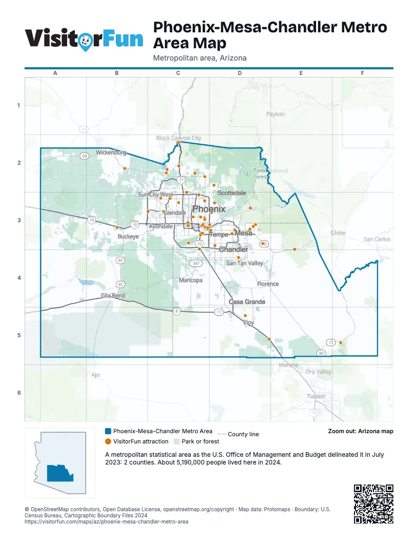
Highway index of Phoenix-Mesa-Chandler Metro Area
Each highway on the sheet and the grid squares it crosses.
- I-8A4, A5, B4, C5, D5
- I-10A3, B3, C3, C4, D4, D5, E5
- I-17C2, C3
- US 60A2, B2, C3, D3, E3, E4
- US 80B3, B4, D3, E4, E5
- US 93B2
- AZ 24D3
- AZ 51C3
- AZ 74B2, C2
- AZ 77E5, F4, F5
- AZ 84C4, C5
- AZ 85B3, B4
- AZ 87D2, D3
- AZ 101C3, D3
- AZ 143C3
- AZ 202C3, D3
- AZ 303B3, C2, C3
- AZ 347C4
Things to do on the Phoenix-Mesa-Chandler Metro Area map
- Apache Trail Tours
- Arizona Heritage Center at Papago Park
- Arizona Mills
- Arizona Outdoor Fun
- Arizona Renaissance Festival
- Arizona Science Center
- Arrowhead Towne Center
- Biltmore Fashion Park
- Biosphere 2
- Boyce Thompson Arboretum
- Casino Arizona
- Cave Creek Trail Rides
- Desert Belle Cruises
- Desert Botanical Garden
- Desert Diamond Casino West Valley
- Desert Diamond Casino White Tanks
- Detours American West
- Discover Salt River Visitor Center
- Dolly Steamboat
- Downtown Phoenix
- Elite Jewelry & Loan
- Goldfield Ghost Town
- Golfland Sunsplash
- Hall of Flame Museum of Firefighting
- Heard Museum
- Hot Air Expeditions
- Kierland Commons
- Koli Equestrian Center
- Lake Pleasant Cruises
- MacDonald's Ranch
- Martin Auto Museum
- Mesa Asian District
- Musical Instrument Museum
- OdySea Aquarium
- Orpheum Theatre
- Outlets North Phoenix
- Papago Park (Hole-in-the-Rock)
- Pecan Lake Entertainment
- Phoenix Zoo
- Pleasant Water Sports
- Rainbow Ryders Hot Air Balloon Rides
- Rooster Cogburn Ostrich Ranch
- Scottsdale Fashion Square
- Skydive Arizona
- Skydive Buckeye
- Stellar Adventures
- Superstition Springs Center
- Superstition Zipline
- Taliesin West
- Talking Stick Resort
- Tanger Outlets Glendale
- Tempe Marketplace
- The Duttons
- Wandering Heart Adventures
- Western Spirit: Scottsdale's Museum of the West
- Westgate Entertainment District
- Westside Recreation
- Wild Horse Pass Hotel & Casino
- Wildlife World Zoo Aquarium and Safari Park
- Yak N Sup
Places on the map
- Avondale
- Buckeye
- Casa Grande
- Chandler
- Eloy
- Florence
- Gila Bend
- Glendale
- Maricopa
- Mesa
- Phoenix
- San Tan Valley
- Scottsdale
- Sun City West
- Tempe
- Wickenburg
© OpenStreetMap contributors, Open Database License, openstreetmap.org/copyright · Map data: Protomaps · Boundary: U.S. Census Bureau, Cartographic Boundary Files 2024