

Arizona map
Yuma map
About 103,559 people live here (Census Bureau, 2024 estimate). The sheet's index lists 300 streets; Robert A. Vaughan Expressway, Blue Star Memorial Highway and South Avenue A cross the most grid squares. Things to do inside the boundary: Yuma Crossing National Heritage Area.
Open the map (PDF, US Letter)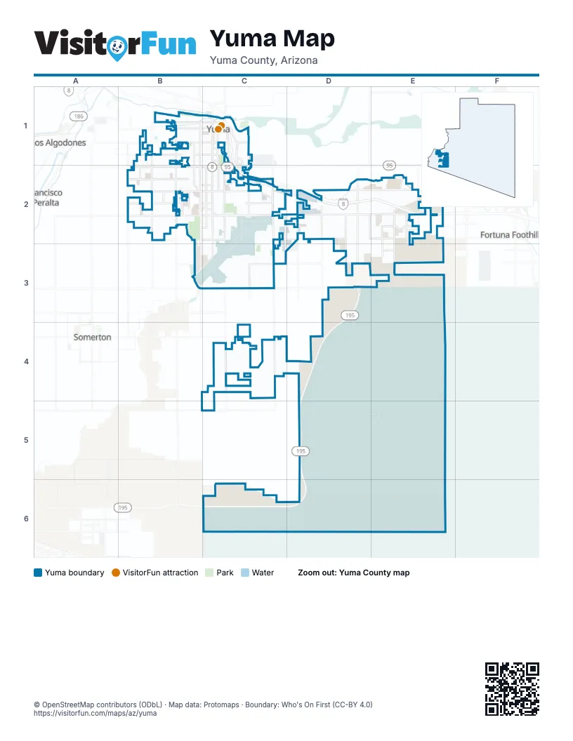
Street index of Yuma
Each street on the sheet and the grid squares it crosses.
- Blue Star Memorial HighwayC1, C2, D2, E2
- Robert A. Vaughan ExpresswayD2, D3, D4, D5, C6, D6
- East 32nd StreetC2, D2, E2
- South 4th AvenueC1, C2, C3
- South Avenue 8 EastE2, E3
- West 32nd StreetB2, C2
- West 16th StreetB2, C2
- South Avenue BB1, B2
- North Frontage RoadE2
- East 16th StreetC2
- South Araby RoadD2
- North 4th AvenueC1
- South Avenue 8½ EastE2
- East 24th StreetC2, D2, E2
- South Avenue 3 EastC2, C3, C4
- South Avenue AB1, B2, B3, B5
- South Avenue CB1, B2
- West 24th StreetB2, C2
- East County 14th StreetC3, D3, E3
- South Pacific AvenueC1, C2
- West 8th StreetB1, C1
- Harold C Giss ParkwayC1
- West 1st StreetB1, C1
- South Redondo Center DriveC1, C2
- South Frontage RoadE2
- South Avenue 9 EastE2
- East 32nd SreetE2
- East 40th StreetC2, D2, E2
- East Gila Ridge RoadC2, D2, E2
- West 20th StreetB2, C2
- West 28th StreetB2, C2
- South Arizona AvenueC1, C2, C3
- South Avenue 2 EastC3, C4
- South 8th AvenueC1, C2
- East County 13th StreetC3, D3
- South Avenue 5 EastD2, D3, D4
- South Avenue 6 EastD2, D3
- West 12th StreetB1, C1
- South 1st AvenueC1, C2
- South Avenue 1 EastC3, C4
- East 36th StreetC2, D2, E2
- South Avenue 3 1/2 EastC2, C3, D4
- West 14th StreetB1, C1
- South Madison AvenueC1, C2
- South 14th AvenueB1, B2
- South Avenue 7 EastD2, D3
- East Palo Verde StreetC2
- South Avenue 4 EastD2, D4
- South Castle Dome AvenueC1
- South 33rd DriveB1, B2
- O'Neill StreetC2, C3
- South 21st DriveB1, B2
- West 3rd StreetB1, C1
- West County 12th StreetB2
- West 22nd StreetB2, C2
- South 4th Avenue (West Airport Loop)C2, B3, C3
- South Avenue 10 EastE2, E3
- South Avenue DB2
- South 18th AvenueB2
- Mississipi AvenueE2, E3
- Otondo DriveE2
- South Avenue 8 1/2 EastE2, E3
- South Mesa AvenueC2, E2
- County 10 1/2 StreetE2
- West 10th StreetB1, C1
- 44th StreetD3, E3
- East 8th StreetC1
- South Avenue A (West Airport Loop)B3
- South Orange AvenueC1
- East 10th StreetC1
- West 40th StreetB2, C2
- South 45th AvenueB2
- Loesch StreetC3
- South 21st AvenueB1, B2
- West 36th StreetB2, C2
- Martini AvenueC2, C3
- West County 19th StreetB5
- Yuma Palms ParkwayC1, C2
- West Catalina DriveC2
- 36th StreetE2
- East County 19th StreetB5, C5
- East 48th StreetD3
- West Palmcroft DriveB2, C2
- South Elks LaneB2
- East 1st StreetC1
- Penitentiary AvenueC1
- West 22nd DriveB2
- South Yuma Palms ParkwayC1
- MCAS North GateC2
- Range RoadD5, E5, E6
- East 26th StreetC2, D2, E2
- Airport Perimeter Service RoadC2, B3, C3
- South 6th AvenueC1, C2
- East County 17th StreetC4, D4
- East 26th PlaceC2, D2, E2
- East 30th StreetC2, D2, E2
- West 18th StreetB2, C2
- South 10th AvenueB1, B2, C2
- South 7th AvenueC1, C2
- East 25th StreetC2, D2, E2
- Boyington LoopE3
- East County 18th StreetC4, D4
- South 5th AvenueC1, C2
- South 9th AvenueC1, C2
- South 3rd AvenueC1, C2
- East Co 13th StreetE3
- South 2nd AvenueC1, C2
- West 27th StreetB2, C2
- East 24th PlaceC2, D2, E2
- South 17th AvenueB1, B2
- East 25th PlaceC2, D2, E2
- West 15th StreetB1, C1
- B Main LateralC4
- South Avenue 2 1/2 EastC2, C4
- West 17th StreetB2, C2
- West 13th StreetB1, C1
- West 26th StreetB2, C2
- South Magnolia AvenueB1, B2
- West 21st StreetB2, C2
- East County 16th StreetC4, D4
- West 17th PlaceB2, C2
- West 11th StreetB1, C1
- East 37th StreetD2, E2
- West 19th StreetB2, C2
- West 5th StreetB1, C1
- South Maple AvenueC1, C2
- West 20th PlaceB2, C2
- South 11th AvenueB1, B2
- West Colorado StreetB1, C1
- West 21st LaneB2
- South Ordnance Loop RoadC3
- South 13th AvenueB1
- West 21st PlaceB2, C2
- East 12th StreetC1
- South 20th AvenueB1, B2
- West 7th StreetB1, C1
- West 4th StreetB1, C1
- West 13th PlaceB1
- East 38th StreetC2, D2, E2
- West 25th StreetB2, C2
- South Barkley Ranch AvenueB2
- West 27th LaneB2
- East 39th StreetC2, D2, E2
- West Water StreetB1, C1
- West 12th LaneB1
- North Ordnance Loop RoadC3
- West 23rd StreetB2, C2
- South 15th AvenueB1, B2
- East 38th PlaceC2, D2, E2
- West 6th StreetB1, C1
- East 42nd PlaceD3, E3
- West 27th PlaceB2, C2
- West 18th PlaceB2
- West 16th PlaceB2
- South Avenue 5 1/2 EastD2, D3
- East 20th StreetC2
- South 31st DriveB1, B2
- West County 17 1/2C4
- West 9th StreetB1, C1
- East 30th PlaceD2
- Avenue 3EC2, C6
- County 11 1/2 StreetD2
- West 38th Blk StreetB2
- South Walnut AvenueC2
- West 2nd StreetB1, C1
- South 19th AvenueB1, B2
- Desert Willow WayE2, E3
- East 33rd PlaceC2, D2, E2
- West 19th PlaceB2, C2
- South Dora AvenueB1, B2
- Airport LoopC3
- South 28th DriveB1, B2
- East 46th StreetD3
- East 36th PlaceE2
- West 12th PlaceB1
- East 5th StreetB1, C1
- East Olive Ann LaneE2
- East 35th PlaceD2, E2
- East 24th LaneD2, E2
- East 35th StreetD2, E2
- Keith AvenueC3
- East Telegraph StreetD2
- West 30th StreetB2
- South 34th DriveB2
- South 16th AvenueB1, B2
- South 47th DriveB2
- Parasio ParkwayE2
- East 37th PlaceD2, E2
- South 24th AvenueB1
- South 48th WayB2
- South 37th DriveB1, B2
- South Boxwood AvenueD2, D3
- West 29th StreetB2, C2
- South 32nd AvenueB2
- South 46th AvenueB1, B2
- West 26th PlaceB2
- South Salida del Sol AvenueE2
- South 22nd AvenueB1, B2
- Quilter StreetC2
- South Puesta del Sol AvenueE2
- East 27th StreetC2, E2
- South 44th AvenueB1, B2
- East Hacienda DriveC2
- East 34th LaneD2, E2
- East Main Canal RoadB1
- West 20th LaneB2
- South 46th DriveB2
- South Cedar AvenueE2, E3
- East 45th PlaceD3, E3
- South 12th AvenueB1
- East 46th LaneD3, E3
- South 47th AvenueB2
- South 36th DriveB1, B2
- West 19th LaneB2
- East 45th StreetD3, E3
- South Olivia AvenueC2
- South Mary AvenueC2
- East Topeka PlaceE2
- East Lorenzo LaneE2
- West 22nd LaneB2
- West 31st PlaceB2
- Avenue 5 1/2 EastD2
- East 44th PlaceD3, E3
- West 31st LaneB2
- South Arena DriveB1
- East 41st LaneE2, D3
- West 37th StreetB2, C2
- 34th StreetD2, E2
- East 34th PlaceE2
- East 36th LaneD2, E2
- East 42nd StreetC3, D3
- Avenue 7 EastD2, E3
- South Gila StreetC1
- West 13th LaneB1
- East 22nd StreetC2
- South Hinckley DriveE2
- South Jasmine AvenueD2, D3
- East View ParkwayD2
- South Engler AvenueC2
- South 45th DriveB2
- Aldrich StreetC2
- South Jojoba AvenueD2, D3
- South Main StreetC1
- East 9th StreetC1
- West 34th PlaceB2, C2
- Hart StreetC2
- Desert Springs DriveE2
- East La Mesa StreetC2
- South Santana DriveE2
- Party Time BoulevardD2
- East 27th PlaceC2, D2
- Almost Heaven StreetD2
- East 34th StreetD2, E2
- East 43rd StreetC3, D3
- East County 9 1/2 StreetE2
- East 23rd StreetC2
- East 21st StreetC2
- South Winsor AvenueC2
- School Bus OnlyB1, B2
- East 38th LaneD2, E2
- Monegan LoopC3
- West 36th PlaceB2, C2
- East 39th PlaceC2, D2, E2
- West 25th PlaceB2
- East 47th StreetD3
- South Fortuna AvenueC2
- South Maiden LaneC1
- West del Plata LaneB2
- County 10th StreetC2, D2
- South Naples AvenueB2
- South Virginia DriveC2
- West 28th PlaceB2
- Hollywood VistaE2
- South 31st AvenueB2
- Co 13 1/2 StreetE3
- 17 3/4 StreetC4, D4
- East Mission StreetD2
- De La Garza LoopC3
- East 18th StreetC2
- West 34th StreetB2, C2
- 30th StreetD2
- Victoria WayD2
- South Athens AvenueB2
- South Michigan AvenueD2
- Rio Vista DriveC1
- East County 13 1/2 StreetE3
- South Crossing AvenueD2
- Avenue 7 1/2 EastE2
- South 35th DriveB1, B2
- 33rd PlaceD2
- South 40th DriveB1, B2
- South View ParkwayD2
- South Sage AvenueE2
- West 22nd PlaceB2, C2
- Araby Blaisdell RoadE2
- West del Oro LaneB2
- South Factor AvenueC2
- West 29th LaneB2
- Driftin AvenueD2
- West 17th LaneB2
Things to do on the Yuma map
Places on the map
- 24th St Plaza
- Alarcon Center
- Arc Center
- Arizona Market Place
- Arizona Port of Entry
- Arizona West RV Park
- Auxiliary Airfield 2 Bivouac
- Big Curve Shopping Center
- Blue Sky Ranch RV Park
- Boyington Loop
- Capri RV Resort
- Carefree Village Resort
- Carver Elementary School
- Carver Park
- Castle Dome Middle School
- Centennial Middle School
- Desert Hills Golf Course
- Engler Estates
- Gila Ridge High School
- Hacienda Estates
- James P Deyo Community Complex
- Kofa High School
- Las Palmillas Shopping Center
- Meadowbrook
- Mesa Verde RV Resort
- Palo Verde Village
- Rio Vista Commerce Center
- San Marcos Villas
- South Combat Aircraft Loading Area
- Southgate
- Sun Vista RV Resort
- The Palms RV Resort
- Tuscany Plaza
- Westwind RV & Golf Resort
- Yuma Commerce Center
- Yuma Golf and Country Club
- Yuma International Airport
- Yuma Palms Regional Center
- Yuma Rehabilitation Hospital
- Yuma Territorial Prison State Historic Park
Next to Yuma
- Fortuna Foothills
- Los Algodones
- Somerton map
© OpenStreetMap contributors, Open Database License, openstreetmap.org/copyright · Map data: Protomaps · Boundary: Who's On First (CC-BY 4.0); Quattroshapes (CC BY 2.0)















