

California map
Anaheim map
About 344,561 people live here (Census Bureau, 2024 estimate). The sheet's index lists 96 streets; Riverside Freeway, Santa Ana Freeway and East La Palma Avenue cross the most grid squares. Things to do inside the boundary: Anaheim Topgolf Swing Suite, Discount Tickets & Tours and Disneyland Park.
Open the map (PDF, US Letter)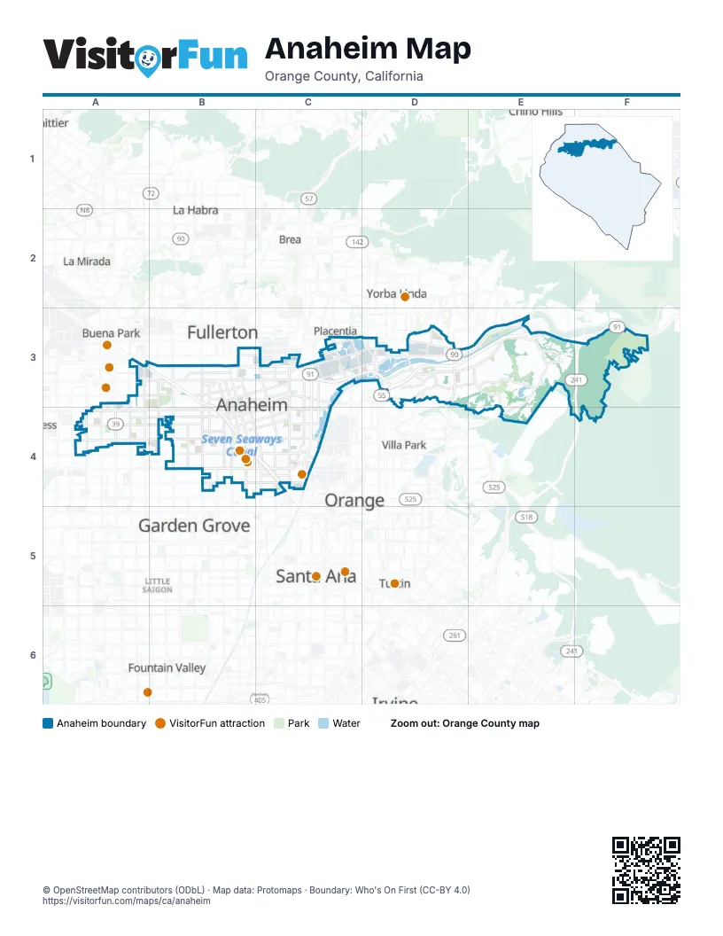
Street index of Anaheim
Each street on the sheet and the grid squares it crosses.
- Artesia FreewayA3
- Artesia TollwayA3
- Beach BoulevardA3, A4
- La Palma AvenueA3
- Magnolia AvenueA3
- North Magnolia AvenueA3, A4
- Santa Ana FreewayA3, B3, B4, C4
- West La Palma AvenueA3, B3
- Brookhurst RoadB3
- East La Palma AvenueB3, C3, D3, E3
- East Lincoln AvenueB3, C3
- East Orangethorpe AvenueB3, C3
- Harbor BoulevardB3, B4
- North Anaheim BoulevardB3
- North Brookhurst StreetB3, B4
- North Euclid StreetB3, B4
- Riverside FreewayB3, C3, D3, E3, F3
- South Anaheim BoulevardB3, B4, C4
- South Euclid StreetB3, B4
- West Lincoln AvenueB3, A4, B4
- Kraemer BoulevardC3
- North East StreetC3
- North Glassell StreetC3
- North Kraemer BoulevardC3
- North State College BoulevardC3
- Orange FreewayC3, C4
- Orangethorpe AvenueC3, D3
- South Kraemer BoulevardC3
- South Placentia AvenueC3
- South Raymond AvenueC3
- South State College BoulevardC3, C4
- 91 Express LanesD3, E3, F3
- Costa Mesa FreewayD3
- Del Cerro DriveD3
- East Imperial HighwayD3
- East Nohl Ranch RoadD3, E3, E4
- East Riverdale AvenueD3
- Esperanza RoadD3
- Imperial HighwayD3
- Kellogg DriveD3
- Lakeview AvenueD3
- North Santiago BoulevardD3
- North Tustin AvenueD3
- Riverdale AvenueD3
- Santa Ana Canyon RoadD3, E3, F3
- South Imperial HighwayD3
- South Lakeview AvenueD3
- East Canyon Rim RoadE3
- Eastern Transportation CorridorE3, F3, F4
- Fairmont BoulevardE3
- HOV 3+ LaneE3
- Serrano AvenueE3, E4
- South Serrano AvenueE3
- Weir Canyon RoadE3
- Yorba Linda BoulevardE3
- Gypsum Canyon RoadF3
- Ball RoadA4
- Knott AvenueA4
- North Western AvenueA4
- Orange AvenueA4
- Orangeview Junior High SchoolA4
- South Beach BoulevardA4
- South Knott AvenueA4
- South Magnolia AvenueA4
- West Ball RoadA4, B4, C4
- West BroadwayA4, B4
- West Orange AvenueA4
- Western AvenueA4
- Brookhurst StreetB4
- Disney WayB4, C4
- Disneyland DriveB4
- East BroadwayB4
- Euclid StreetB4
- Orangewood AvenueB4
- South Brookhurst StreetB4
- South Disneyland DriveB4
- South Harbor BoulevardB4
- West Chapman AvenueB4
- West Katella AvenueB4, C4
- West Orangewood AvenueB4, C4
- West StreetB4
- Anaheim BoulevardC4
- Anaheim WayC4
- East Ball RoadC4
- East Cerritos AvenueC4
- East Katella AvenueC4
- East Orangewood AvenueC4
- Manchester AvenueC4
- River RoadC4
- South Douglass RoadC4
- South Lewis StreetC4
- South Manchester AvenueC4
- Stanley Cup WayC4
- West Taft AvenueC4
- East Serrano AvenueE4
- South Nohl Ranch RoadE4
Things to do on the Anaheim map
Places on the map
- Anaheim
- Anaheim Convention Center
- Anaheim Coves Park
- Anaheim Hills Golf Course
- Anaheim Lake
- Anaheim Mobile Home Estates
- Anaheim Plaza
- Anaheim Shores
- Anaheim Town Square
- Burris Basin
- Dad Miller Golf Course
- Deer Canyon Park Preserve
- Disneyland
- Disneyland Resort
- Downtown Disney
- Esperanza High School
- Friendly Village of Anaheim
- Guardians of the Galaxy: Mission Breakout
- Jungle Cruise
- Kindred Community Church
- Lower Five Coves Basin
- Oak Canyon Nature Center
- Pepperwood
- Periphery Road
- Peter Pan's Flight
- Ponderosa Mobile Home Estates
- Radiator Springs Racers
- Rancho La Paz
- Raymond Retarding Basin
- Rio Vista Mobile Home Estates
- Roger Rabbit's Car Toon Spin
- Soarin' Around the World
- Space Mountain
- Stadium Landing
- Stadium Plaza Business Park
- Star Wars: Rise of the Resistance
- Summit Court
Next to Anaheim
- Brea
- Buena Park
- Chino Hills
- Fountain Valley
- Fullerton
- Garden Grove
- La Habra
- La Mirada
- Little Saigon
- Orange
- Placentia
- Santa Ana map
- Tustin
- Villa Park
- Westminster
- Whittier
- Yorba Linda
© OpenStreetMap contributors (ODbL) · Map data: Protomaps · Boundary: Who's On First (CC-BY 4.0)