

California map
Tustin map
About 78,863 people live here (Census Bureau, 2024 estimate). The sheet's index lists 300 streets; Jamboree Road, Tustin Ranch Road and Red Hill Avenue cross the most grid squares. Things to do inside the boundary: Intrepid Escape Rooms.
Open the map (PDF, US Letter)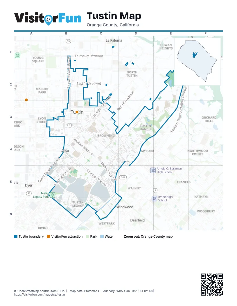
Street index of Tustin
Each street on the sheet and the grid squares it crosses.
- Jamboree RoadF1, E2, F2, E3, D4, E4, C5, B6, C6
- Santa Ana FreewayB3, C3, C4, D4
- Costa Mesa FreewayB1, B2, B3, B4
- CA 55 South HOVB3, B4
- Garden Grove FreewayB1
- Tustin Ranch RoadD3, E3, C4, D4, C5, B6, C6
- Red Hill AvenueC3, B4, C4, A5, B5
- Newport AvenueC2, B3, C3, B4
- Edinger AvenueB4, B5, C5, C6
- Irvine BoulevardB3, C3, D3, D4
- East Warner AvenueA5, B5, B6
- Sycamore AvenueB4, C4, C5
- Barranca ParkwayA5, B5, B6
- East 17th StreetB2, C2
- Portola ParkwayE3
- East 4th StreetB3
- Irvine Center DriveC6
- El Camino RealB3, C3, C4, D4
- Bryan AvenueC3, C4, D4
- Walnut AvenueB4, C4, C5
- Yorba StreetB1, B2, B3
- East 1st StreetB3, C3
- West 1st StreetB3
- Harvard AvenueC6, D6
- East Main StreetB3, C3
- Browning AvenueD3, C4
- San Juan StreetC3, C4
- McFadden AvenueB4
- Prospect AvenueB2, B3
- Del Amo AvenueC3, B4, C4, B5
- Pasadena AvenueB3, B4
- East Santa Clara AvenueB2
- Holt AvenueC3
- Warner AvenueB6, C6
- North Tustin AvenueB3
- Old Irvine BoulevardC3
- North Prospect AvenueB3
- Valencia AvenueB4, B5, C5
- Moffett DriveB5, C5, C6
- Park AvenueC5, B6, C6
- Pioneer RoadE1, F1, E2, F2, E3
- Armstrong AvenueB5, B6
- Myford RoadD4, C5, D5
- Nisson RoadB3, C3, C4
- Robinson DriveD3, D4
- Mitchell AvenueB3, B4, C4
- Parkcenter LaneC4, D4
- Victory RoadB5, C6
- Auto Center DriveD4
- South B StreetB3, B4
- Franklin AvenueC4, C5
- West Main StreetB3
- Tustin Village WayB3
- Heritage WayD4
- Flight WayB5, B6
- Pacific StreetB3, B4
- Williams StreetB3, B4
- Dow AvenueC5
- La Colina DriveD3
- Legacy RoadB5, C5, B6
- Amaganset WayB3
- Chambers RoadC4, C5
- District DriveB6
- Compass AvenueB5, B6
- Vandenberg LaneB2
- Severyns RoadB5
- West 6th StreetB3
- Michelle DriveC4, D4
- Warren AvenueC2
- Tustin East DriveC4
- Carroll WayB2
- Kensington Park DriveC5
- Keller DriveD4
- Columbus Grove DriveC6
- Orange StreetC3
- Centennial WayC3
- South Prospect AvenueB3
- Alliance AvenueB3
- Greenway DriveD3
- Theodora DriveB2
- Deerfield AvenueC4, D6
- Champion WayE3
- Patriot WayE2
- Enderle Center DriveB2
- Aston StreetB6
- Foothill BoulevardD1
- Township DriveD3, E3
- Charloma DriveC3, B4, C4
- Marshall LaneB1, B2
- South Myrtle AvenueB3, B4
- Airship AvenueB5, B6
- Hannaford DriveE2
- Norwood ParkB2
- Cherrywood LaneC4, C5
- Barnes RoadC6
- Sonora StreetC6
- Raintree RoadC4
- Charleston StreetB5, C5
- Lance DriveC3, C4
- Malena DriveB2
- Fashion LaneC3
- Utt DriveC3, C4
- Woodlawn AvenueC3, B4, C4
- Montgomery StreetB5, C5
- South C StreetB3
- Acacia DriveB2, B3
- Bell AvenueB5
- Emerson BendE2
- Rawlings WayE3
- Peters Canyon RoadE2
- Woodland DriveC3
- Raintree LaneC4, C5
- Downs RoadC6
- Orange Tree LaneB2
- Loretta DriveB2
- Rogue River BendE2
- West 3rd StreetB3
- Alder LaneC4, C5
- Hoxie DriveE2, E3
- Tustin Ranch PlazaD4
- Wellington AvenueB2
- Jacaranda AvenueB2
- Prospect ParkB3, C3
- Carfax DriveB4
- Coventry WayC5
- Majestic DriveD4
- West 2nd StreetB3
- Brookshire AvenueB4, C5
- Swaim WayB6
- Roanoke AvenueC4
- Paseo CirculoD4
- Voyager DriveC6
- AllenE3
- Horizon WayE2
- Veterans WayB5, B6
- Diamond Head DriveC3
- North B StreetB3
- Farmington RoadC3, C4
- Windrow RoadC6
- Medford AvenueB2
- Devonshire AvenueB4, C4
- Club HouseD3, E3
- Laurie LaneB2
- Madison StreetB5, C5
- Miguel RoadE3
- Galy StreetB2
- Canterbury AvenueC4, C5
- Columbus SquareB5, C5
- Elizabeth WayC3
- West DriveD4
- Fairmont WayB2
- Bronzewood DriveE2
- Service RoadB4
- Andrews StreetC3, C4
- Wass StreetC3
- Dawn WayB5, B6
- Stonehenge DriveC3, C4
- Helber WayB5, B6
- Parkway LoopB4, B5
- Pioneer WayE3
- Village DriveB2
- Parker DriveB2
- Lexington StreetB5, C5
- South A StreetB3
- Ebel RoadB3
- Mosher AvenueB5
- Lansdowne RoadB5
- Pieper LaneD3
- Via LindoB2
- Flyers LaneC6
- Fowler AvenueC1, D3, D4
- Georgia StreetC5
- Aspen StreetC4, D4
- Copperfield DriveC4
- Laurinda WayB2, C2
- Via CalmaB2
- Olwyn DriveC3
- De Anza LaneB3
- Tustin Grove DriveB4
- Apple Tree DriveC5
- South RivieraE3
- Wheeler PlaceB2
- Barlett PlaceC6
- Bonner DriveB2
- Garland AvenueC3
- Windwalker WayC5, C6
- Silk Tree DriveC5
- California StreetB3, B4
- Mosscreek StreetC6
- Polaris DriveC6
- Cloverbrook DriveC4
- Packers CircleC3
- Beneta WayB3, C3
- Granada StreetC4
- Honeybee DriveC6
- Madrid StreetC4
- Falmouth DriveC3, C4
- Caper Tree DriveC5
- Malaga StreetC4
- Lagier WayD4
- Coco Palm DriveC5
- Hudson DriveC6
- Kalua LaneC3
- Ranchwood RoadD3
- Melvin WayC3
- Seville StreetC4
- Laviana StreetC6
- Pinehurst DriveD3
- Pinewood RoadC4, C5
- Burnt Mill RoadC4, D4
- Fig Tree DriveC4, C5
- East 3rd StreetB3, C3
- Albee AvenueF1
- Plaza DriveC3
- Jessup WayC3
- East 6th StreetB3, C3
- Larkspur StreetC6
- Astoria WayB5, C5
- Morning Glory RoadC4
- Orchid AvenueC6
- Matthews DriveE2
- Sherbrook DriveB2
- CortinaD3, D4
- Danborough RoadC4
- Hyannis Port RoadC4
- Mimosa LaneB2, B3
- Westfall RoadB4, C4
- Belleford RoadD3
- Bigelow ParkB2
- Chelsea WayB3
- Miller DriveB3
- Cardamon WayC6
- Stafford PlaceC6
- Emerywood RoadB4, C4
- Westbury LaneB3
- Carfax AvenueC3, C4
- LambertD3, E3
- Ballesteros LaneD3, D4
- Sunningdale DriveD3
- Epping WayC3
- Santa Fe DriveB4, B5
- Amberdale DriveE2
- ComancheC4
- Industrial DriveB4
- Jasmine PlaceC6
- Almond StreetC4, D4
- Player LaneD3, E4
- School LaneB4
- IroquoisC4
- Mountain View DriveB3
- North A StreetB3
- Foxcroft RoadC5
- Braeburn RoadB4
- Bridgeport RoadB4
- Bruns DriveE2
- Featherhill RoadC4, C5
- SavannaD4
- Sun Dial DriveC6
- Wickshire LaneD3
- Skylar PlaceB6
- East 2nd StreetB3, C3
- Lucero WayC2
- MontecitoD4
- Oxford AvenueC4
- Avenita AlperaD4
- Nectarine StreetC6
- Camilia AvenueC6
- Hiskey LaneE2
- Cromwell DriveC3
- Balboa LaneB3
- Gallery WayD3, E3
- Harvest CircleC4
- AquasantaD3
- Aviator Lane SouthC6
- StagecoachC4
- Crawford DriveD3
- Mauna Loa RoadC3
- East Coronado LaneB3
- Goetting AvenueE3
- Moonstone CircleB6
- Turnleaf LaneE2
- Stella CircleB5, B6
- MastersD4
- North RivieraE3
- ArapahoeC4
- Saddleback RoadB3
- Liberty StreetC5, D6
- Tiburon WayD4
- Prescott AvenueD3
- Redwood DriveD4
- Ternberry CourtD3
- CherokeeC4
- Greenmeadow AvenueB4, C4
- Maxwell DriveD3
- Overlook PointE2
- Peebler WayB5, B6
- Phillips StreetE2
- Green Valley DriveC3
- Chatham DriveB2
- Anglin LaneB2, C2
Things to do on the Tustin map
Places on the map
- Aldersgate United Methodist
- Alley Grove Promenade
- C. E. Utt Middle School
- Cedar Grove Park
- Centennial Park
- Centurion Business Park
- Citrus Ranch Park
- Columbus Tustin Middle School
- Comerica Bank
- Costco Shopping Center
- Coventry Way
- Create Tustin
- Dow Avenue Industrial Park
- Dow Business Center
- Franklin Court
- Heritage Elementary
- Hillview High School
- I-5 Self Storage
- Jamboree Plaza
- Ladera Elementary School
- Lafayette Square
- Larwin Square
- Legacy Magnet Academy
- Loft
- Lower Peters Canyon Reservoir
- MCAS Tustin Blimp Hangar
- Pacfic Center
- Pacific Office Plaza
- Peters Canyon Regional Park
- The District at Tustin Legacy
- The Market Place
- Tustin Auto Center
- Tustin Business Park
- Tustin Gateway Business Park
- Tustin High School
- Tustin Legacy Park
- Tustin Plaza
- Tustin Ranch Golf Club
- Village at Tustin Legacy
Next to Tustin
- Cedar Evergreen
- Cornerstone Village
- Cowan Heights
- Deerfield
- Delhi
- Dyer
- Eastwood
- El Camino Real
- Fairbridge Square
- Frances
- Grand Sunrise
- Hewes Park
- Kathryn
- La Paloma
- Lemon Heights
- Logan
- Lower Peters Canyon
- Lyon Street
- Mabury Park
- Madison Park
- Mirasol
- Myford
- North Tustin
- Northwood
- Northwood Pointe
- Orchard Hills
- Pacific Park
- Panorama Heights
- Saddleback View
- San Mateo map
- The Groves
- Walnut map
- Westpark
- Windwood
- Woodbury
- Woodbury East
- Young Square
© OpenStreetMap contributors, Open Database License, openstreetmap.org/copyright · Map data: Protomaps · Boundary: Who's On First (CC-BY 4.0); Quattroshapes (CC BY 2.0)















