

California map
Bakersfield map
About 417,468 people live here (Census Bureau, 2024 estimate). The sheet's index lists 98 streets; Chester Avenue, White Lane and 7th Standard Road cross the most grid squares. Things to do inside the boundary: Buena Vista Museum of Natural History & Science.
Open the map (PDF, US Letter)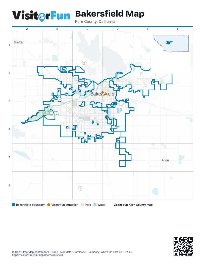
Street index of Bakersfield
Each street on the sheet and the grid squares it crosses.
- 7th Standard RoadA2, B2, C2
- Galpin StreetA2
- Allen RoadB2, B3
- Hageman RoadB2, C2
- Olive DriveB2, C2
- Santa Fe WayB2
- Snow RoadB2, C2
- Zerker RoadB2
- Airport DriveC2
- Buck Owens Access RoadC2
- Buck Owens BoulevardC2, C3
- Calloway DriveC2, B3, C3
- Chester AvenueC2, D2, C3, D3
- Coffee RoadC2, C3
- Fruitvale AvenueC2
- Golden State AvenueC2, C3, D3
- Golden State HighwayC2, C3, C4
- Knudsen DriveC2
- Mohawk StreetC2, C3
- Mowhawk StreetC2
- North Chester AvenueC2
- Riverlakes DriveC2
- Alfred Harrell HighwayD2, E2
- Auburn StreetD2, E2
- CHP Officer David W. Manning Memorial FreewayD2, E2, D3
- Columbus StreetD2
- East China Grade LoopD2
- Fairfax RoadD2, D3
- Haley StreetD2, D3
- Height StreetD2
- Manor StreetD2
- McMannus RoadD2
- Mount Vernon AvenueD2, D3
- Oswell StreetD2, D3
- Panorama DriveD2
- River BoulevardD2
- Round Mountain RoadD2
- Union AvenueD2, D3
- West Columbus StreetD2
- CHP Officer David W. Manning Memorial HighwayE2
- Comanche DriveE2
- Kern Canyon RoadE2, F2, E3
- Masterson StreetE2
- Morning DriveE2, E3
- Paladino DriveE2
- Buena Vista RoadB3, B4
- Ming AvenueB3, C3, D3
- Old River RoadB3, C3, C4
- Renfro RoadB3
- Rosedale HighwayB3, C3
- South Allen RoadB3, B4
- South Heath RoadB3
- Stockdale HighwayB3, C3
- Westside ParkwayB3, C3
- White LaneB3, C3, C4, D4
- 23rd StreetC3, D3
- 24th StreetC3, D3
- Bakersfield Tehachapi HighwayC3
- Brimhall RoadC3
- Brundage LaneC3, D3
- California AvenueC3, D3
- Centennial CorridorC3
- F StreetC3
- Golden State RoadC3, D3
- Gosford RoadC3, C4
- Loustalot LaneC3, D3
- New Stine RoadC3
- Oak StreetC3
- Richland StreetC3, D3
- Rosa Parks HighwayC3, D3
- South Chester AvenueC3, D3, D4
- Stine RoadC3, C4
- Truxtun AvenueC3, D3
- Valley PlazaC3
- 30th StreetD3
- Bakersfield–Tehachapi HighwayD3
- Beale AvenueD3
- East Brundage LaneD3
- East California AvenueD3
- East Niles StreetD3, E3
- East Truxtun AvenueD3
- Edison HighwayD3
- Espee StreetD3
- Flower StreetD3
- Lincoln StreetD3
- Monterey StreetD3
- Owens StreetD3
- South Oswell StreetD3
- South Union AvenueD3
- West Niles StreetD3
- Enos LaneA4
- Westside FreewayA4
- Panama LaneB4, C4, D4
- Taft HighwayB4, C4, D4
- Ashe RoadC4
- Hosking AvenueC4, D4
- McCutchen RoadC4
- East Panama LaneD4
Things to do on the Bakersfield map
Places on the map
- 2800 Acre Water Bank
- Aera Park
- Bakersfield
- Bakersfield Behavioral Healthcare Hospital
- Bakersfield Municipal Airport
- Bakersfield River Run RV Park
- Calcot
- California State University Bakersfield
- Civic Center
- Crestview Meadows
- Crossroads Business Park
- Del Rio Walking Trail
- Derrel's Mini Storage
- Encompass Health Rehabilitation Hospital Of Bakersfield
- Frontier High School
- Highgate - West Ming Village A
- Kern County Fairgrounds
- Kern Medical Center
- Kern River
- Kern River Parkway Park
- Marketplace Shopping Center
- McAllister Ranch Water Bank
- Memorial Hospital
- Mercy Hospital Southwest
- Mesa Marin Sports Park
- Metropolitan Recreation Center
- Northwest Promenade
- Panorama Park
- PCL Industrial Services
- Rattlesnake Canyon
- Rio Bravo Country Club
- River Lakes Village
- River Oaks Park
- Sierra Metal Works
- St. John's Lutheran Church
- Sundale Country Club
- The Links Golf Course
- The Park at River Walk
- The Polo Greens
- The Springs Apartment Homes
Next to Bakersfield
- Arvin
- Shafter
© OpenStreetMap contributors (ODbL) · Map data: Protomaps · Boundary: Who's On First (CC-BY 4.0)