

California map
Central Valley map
The sheet's index lists 32 highways; I-5, CA 99 and US 99 cross the most grid squares. Things to do inside the boundary: Buena Vista Museum of Natural History & Science, Cache Creek Casino Resort and Fashion Fair Mall. Also on it: Avenal, Bakersfield and Colusa.
Open the map (PDF, US Letter)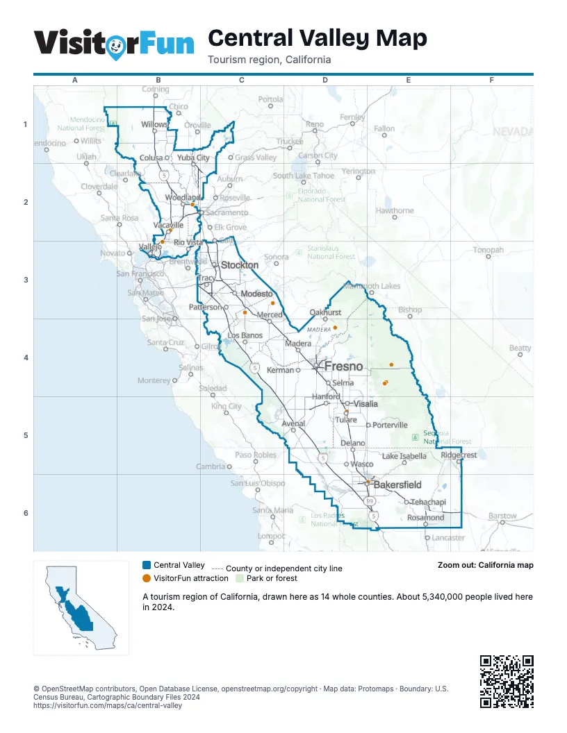
Highway index of Central Valley
Each highway on the sheet and the grid squares it crosses.
- I-5B1, B2, C2, C3, C4, C5, D5, D6, E6
- I-80B2, B3
- I-205B3, C3
- I-505B2
- I-580B3, C3
- I-680B3
- I-780B3
- US 50B2
- US 99D5, D6, E6
- CA 4C3
- CA 12B3, C3
- CA 14E6
- CA 33C4, C5, D5
- CA 37B3
- CA 41D4
- CA 58D6, E6, F6
- CA 59C4
- CA 63D5
- CA 65B2, C2, E5
- CA 70B2
- CA 99B1, B2, C3, C4, D4, D5, D6, E6
- CA 113B2
- CA 120C3
- CA 132C3
- CA 140C4
- CA 152D4
- CA 168D4
- CA 178E5
- CA 180D4
- CA 190D5, E5
- CA 198D5
- CA 204D6, E6
Things to do on the Central Valley map
- Buena Vista Museum of Natural History & Science
- Cache Creek Casino Resort
- Fashion Fair Mall
- General Sherman Tree
- Hilmar Cheese Visitor Center
- Jelly Belly Visitor Center
- Kings Canyon National Park
- Mono Wind Casino
- River Fox Train
- Rowland Freedom Center
- Sequoia National Park
- Sierra Vista Scenic Byway
- Splash-n-Dash Aqua Park
- Tulare Outlet Center
- Visalia Mall
- Weberstown Mall
Places on the map
- Avenal
- Bakersfield
- Colusa
- Delano
- Fresno
- Hanford
- Kerman
- Lake Isabella
- Los Banos
- Madera
- Merced
- Modesto
- Oakhurst
- Patterson
- Porterville
- Ridgecrest
- Rio Vista
- Rosamond
- Selma
- Stockton
- Tehachapi
- Tracy
- Tulare
- Vacaville
- Vallejo
- Visalia
- Wasco
- Willows
- Woodland
- Yuba City
Next to Central Valley
© OpenStreetMap contributors, Open Database License, openstreetmap.org/copyright · Map data: Protomaps · Boundary: U.S. Census Bureau, Cartographic Boundary Files 2024