

California map
Burbank map
About 103,533 people live here (Census Bureau, 2024 estimate). The sheet's index lists 300 streets; North Hollywood Way, Alley n/o Magnolia Boulevard and North Lamer Street cross the most grid squares. Things to do inside the boundary: Burbank Town Center and Warner Bros. Studio Tour Hollywood.
Open the map (PDF, US Letter)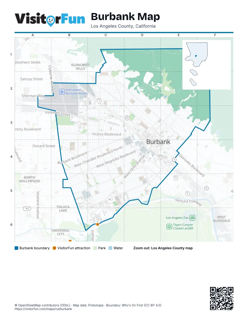
Street index of Burbank
Each street on the sheet and the grid squares it crosses.
- Golden State FreewayC2, C3, D3, D4, E4
- Ventura FreewayB5, C5, D5, C6
- North Hollywood WayB2, B3, B4, B5, C5, C6
- North San Fernando BoulevardB2, C2, C3, D3, D4
- North Buena Vista StreetC2, C3, C4, C5
- West Alameda AvenueD4, E4, C5, D5, B6
- Burbank BoulevardC3, D3, B4, C4
- Empire AvenueA3, B3, C3
- Riverside DriveC5, D5, B6, C6
- West Olive AvenueD4, C5, D5, C6
- Victory BoulevardB3, C3, D3, E5
- Magnolia BoulevardD3, E3, D4, B5
- East Verdugo AvenueE3, D4, E4
- Olive AvenueD4, C5, C6
- North Victory PlaceC3, D3
- South San Fernando BoulevardD4, E4
- South Victory BoulevardD4, D5, E5
- North Victory BoulevardD3, D4
- East Alameda AvenueE3, E4
- Cypress AvenueD3, D4
- North First StreetD3, D4
- Clyborne AvenueB2
- Ikea WayD4
- Hollywood Way Ramp WestB2
- Hollywood Way Ramp EastB2
- South First StreetD4
- San Fernando RoadE4
- South Hollywood WayC6
- Sherman WayB2
- West Verdugo AvenueD4, B5, C5
- North Glenoaks BoulevardC2, D3
- West Magnolia BoulevardB4, C4, D4, B5
- East Olive AvenueD3, E3, D4
- West Chandler Boulevard NorthB4, C4, D4
- West Chandler Boulevard SouthB4, C4, D4
- Vanowen StreetB3, C3
- Edison BoulevardB4
- East Orange Grove AvenueD3, E3, D4
- Clybourn AvenueB3, B4, B5, B6
- Winona AvenueB2, C2
- North 3rd StreetD3, D4
- South Glenoaks BoulevardD3, E3, E4
- North Mariposa StreetC3, D3, C4, D4
- South Main StreetD4, D5
- North Front StreetD3, D4
- South Buena Vista StreetC5
- Bob Hope DriveC5, C6
- West Chandler BoulevardB4
- Bonnywood PlaceD4
- Glenoaks BoulevardE4
- South Front StreetD4
- Cohasset StreetB2, C2
- Hollywood WayB3, C6
- Hollywood Way Southbound RampB3
- Vanowen RampB3
- Hollywood Way Northbound RampB3
- Oxnard StreetB4
- Angeleno AvenueD4
- Alameda AvenueE4
- Kenneth RoadC2, D2, D3, E3
- North Keystone StreetC1, C2, C3, C4, C5
- Scott RoadC2, D2, D3
- North California StreetB2, B3, B4, C4, C5
- North Pass AvenueB4, B5, B6, C6
- North Ontario StreetB2, B3, B4, C4, C5
- Sunset Canyon DriveD2, E2, E3
- East Angeleno AvenueE3, D4
- South Flower StreetD4, E4
- Delaware RoadD2, D3
- South Lake StreetD4, E4
- East Cypress AvenueD3, E3
- Thorton AvenueB3, C3
- Thornton AvenueC3
- Chandler BoulevardD4
- North Lake StreetD4
- Alley n/o Magnolia BoulevardD3, E3, B4, C4, D4, B5
- North Frederic StreetC2, C3, C4, C5
- North Naomi StreetC2, C3, C4, C5
- North Brighton StreetC2, C3, C4, C5
- North Lincoln StreetC2, C3, C4, C5
- North Fairview StreetC3, C4, C5
- North Lamer StreetC1, D1, C2, C3, C4, C5
- North Niagara StreetC3, C4, C5
- North Catalina StreetC3, C4, C5
- West Clark AvenueC4, D4, B5, C5
- Alley s/o Magnolia BoulevardB4, C4, D4, B5
- North Parish PlaceC2, C3, C4, C5
- North Avon StreetB2, B3, B4, C5
- North Myers StreetC2, C3, C4, C5
- Evergreen StreetB3, B4, B5, B6
- North Lima StreetB2, B3, B4, C4, C5
- North Rose StreetB3, B4, B5, B6
- North Screenland DriveB3, B4, B5, C5, C6
- Alley n/o Burbank BoulevardC3, D3, B4, C4
- North Valley StreetB3, B4, B5, B6
- North Bel Aire DriveD2, D3, E3
- Walnut AvenueD1, E1, D2, E2, D3
- West Oak StreetB5, C5, D5
- Alley s/o Burbank BoulevardC3, D3, B4, C4
- North Orchard DriveC2, C3, C4, D4
- North Reese PlaceC2, C3, C4, D4, D5
- Alley n/o Verdugo AvenueE3, D4, E4, B5, C5
- East Harvard RoadE2, D3, E3
- Alley n/o Olive AvenueE3, D4, C5, D5, C6
- Kenwood StreetB2, B3, B4, B5
- East Tujunga AvenueE3, D4, E4
- Pacific AvenueB3, C3
- Alley s/o Chandler BoulevardB4, C4, D4
- North Sparks StreetC2, C3, C4, D4
- Alley e/o Hollywood WayB2, B3, B4, B5, C5
- Alley n/o Chandler BoulevardB4, C4, D4
- Alley s/o Victory BoulevardB3, C3, D3
- Alley w/o Hollywood WayB3, B4, B5, C5
- North Maple StreetB4, B5, C5, C6
- Alley n/o Alameda AvenueE4, B5, C5, D5
- East Providencia AvenueE3, D4, E4
- East Elmwood AvenueE3, F3, E4
- North Sixth StreetD2, D3, E3
- North Beachwood DriveC3, C4, D4
- Haskins Fire RoadD2
- Jeffries AvenueB4, C4
- North Cordova StreetB4, B5, C5
- North Griffith Park DriveC3, C4, D4
- North Whitnall HighwayB4, B5, C5
- East Santa Anita AvenueE3, D4, E4
- Burbank AirportB3
- Alley n/o Clark AvenueC4, D4, B5, C5
- Country Club DriveE2, E3
- Bethany RoadD2, D3
- Florence StreetC4, C5
- Alley n/o Victory BoulevardB3, C3, D3
- Alley w/o Brighton StreetC2, C3, C4, C5
- Tulare AvenueB2, C2
- East Palm AvenueD3, E3, D4
- Amherst DriveD2, D3
- Fifth StreetD2, D3
- Maple StreetB3, B4
- East Valencia AvenueE3, E4
- South Beachwood DriveD4, D5
- South Mariposa StreetD4, D5
- Ontario StreetB3, B4
- Monterey AvenueB3, C3
- Alley n/o Orange Grove AvenueD3, E3, D4
- East San Jose AvenueD3, E3
- Alley n/o Tujunga AvenueE3, E4
- Alley w/o Victory BoulevardD4, D5, E5
- Haven WayC2, D2
- Alley n/o Palm AvenueD3, E3
- Alley w/o Buena Vista StreetC2, C3, C4, C5
- Pepper StreetB3, B4
- South Griffith Park DriveD4, D5
- Alley n/o San Jose AvenueD3, E3
- Cornell DriveD2, D3
- East Fairmount RoadE2, D3
- East Grinnell DriveE2, D3, E3
- Andover DriveD2, D3
- Cedar AvenueE3, E4
- Alley n/o Angeleno AvenueE3, D4
- Alley n/o Santa Anita AvenueE3, E4
- Warner BoulevardC5, B6, C6
- South Sparks StreetD4, D5
- Alley w/o Lincoln StreetC2, C3, C4
- Alley n/o Cypress AvenueD3, E3
- Jolley DriveC2, D2
- Alley w/o Glenoaks BoulevardC2, D3, E3, E4
- South Orchard DriveD5
- Groton DriveC2, D2
- Alley n/o Riverside DriveB5, D5, B6, C6
- Wildwood Canyon RoadE2
- Pass AvenueB3, B4
- Lake StreetD3, D4, E4, E5
- University AvenueD2, D3
- Alley s/o Riverside DriveD5, B6, C6
- Birmingham RoadD2, D3
- Parkside AvenueC5, D5
- Wedgewood LaneC1
- Irving DriveC2, D2
- South Sixth StreetE3, E4
- Alley w/o San Fernando BoulevardB2, C2, C3, D3
- Tufts AvenueD2, D3
- Cambridge DriveD2, D3
- Castleman LaneC1
- South Bel Aire DriveE3
- Alley s/o Clark AvenueD4, B5, C5
- Alley s/o Alameda AvenueD5, C6
- North Kenwood StreetB4, C5, C6
- Chestnut StreetD3, D4
- South Keystone StreetC5, D5
- North 6th StreetC2, D2
- West Providencia AvenueD4
- Parish PlaceD5
- Alley n/o Providencia AvenueE3, D4, E4
- West Elmwood AvenueD4, D5
- Alley n/o Fairmount RoadE2, D3
- Alley n/o Harvard RoadE2, D3, E3
- Alley n/o Grinnell DriveE2, D3, E3
- South Reese PlaceD5
- West Spazier AvenueE4, D5, E5
- West Elm AvenueE4, D5, E5
- Wyoming AvenueB4, C4
- Alley e/o Victory BoulevardD4, D5
- South Lamer StreetC5, D5
- South Glenwood PlaceD4, D5
- Colgin CourtE3, E4
- Eton DriveD2, D3
- West Linden AvenueE4, D5, E5
- Peyton AvenueC2, C3, D3
- West Allen AvenueB4
- West Valleyheart DriveD5, C6
- Lamer StreetC4
- North Manning StreetB3, B4
- Joaquin DriveC1, C2, D2
- South California StreetC5, C6
- Alley n/o Cedar AvenueE3, E4
- South Via MontanaE3
- Stanford RoadC2, D2
- North Lomita StreetD4
- Lockheed View DriveD2, E2
- Alley n/o Empire AvenueB3, C3
- Uclan DriveD2, D3
- Brace Canyon RoadC1, D1, C2
- Grismer AvenueC2, C3
- 8th StreetC6
- South Ikea WayD4, E4
- East AvenueD3
- West Valencia AvenueD4, E4, D5
- Keeler StreetC2, C3
- Alley e/o San Fernando RoadE4
- West Orange Grove AvenueD4
- South Varney StreetD4, E4
- Burton AvenueB2, C2, B3
- West Cedar AvenueD4, D5
- Paseo RedondoF3
- Alley w/o Bel Aire DriveD3, E3
- Viewcrest DriveD2
- North Shelton StreetD4
- South 3rd StreetD4, E4
- Thurber PlaceF3
- South 5th StreetE3, E4
- South 7th StreetE3
- South Virginia AvenueD4, D5
- West Palm AvenueD4
- Sunset Canyon Debris Basin RoadE2, F2
- Alley s/o Verdugo AvenueD4, C5, D5
- Avon StreetC6
- North Toluca Park DriveB5
- Brown DriveC2, D2
- Leland WayC3, D3
- Stephen RoadD2
- Alley s/o Olive AvenueE3, D4, C5, D5
- South Myers StreetC5, D5
- Bonita AvenueC2
- Floyd StreetB2, C2, C3
- Alley e/o Main StreetD4, D5
- De Bell DriveE2
- BroadwayC3, D3
- Alley e/o Bel Aire DriveD2, D3, E3
- Alley n/o Valencia AvenueE4
- Whitnall HighwayB5, C5
- Minnie AvenueC5
- South Lincoln StreetC5
- Alley n/o Elmwood AvenueE4
- Hampton RoadC2, D2
- Alley w/o Avon StreetB5, C5
- McFarlane AvenueB6, C6
- Kenmere AvenueC3
- 3rd StreetC6
- Lima StreetC6
- Alley w/o Myers StreetC3, C4
- Morningside DriveD5
- National AvenueB6, C6
- Alley w/o Edison BoulevardB4
- North Rosemary LaneC5
- South Fairview StreetC6
- West Tujunga AvenueD4
- Hatteras StreetB4
- Sarah StreetB5
- Alley e/o Glenoaks BoulevardC2, E4
- North Priscilla LaneB5
- South Niagara StreetC5, C6
- Magnolia Boulevard FrontageD4
- West Heffron DriveB5, C5
- Alley w/o Florence StreetC5
- Isabel StreetD3, C4
- South Lomita StreetD4, D5
- South Parish PlaceC5, D5
- Alley e/o Valley StreetB4
- South Rose StreetB6, C6
- South Chavez StreetD5
- Alley w/o Fairview StreetC5
- North Ford StreetB5
- Rosita AvenueC2
- West Valhalla DriveB3
- North Glenwood PlaceD4
- North Dymond StreetB3
- North Florence StreetC4
- Jacaranda AvenueB5, C5
- Moss StreetD4, E4
- North Doan DriveC4
- Alley w/o Evergreen StreetB4
Things to do on the Burbank map
Places on the map
- 161 WWTV
- Abraham Lincoln Park
- AMC Burbank 16
- Ashley HomeStore
- Barnes & Noble
- BB Dental Care
- Belmont Village Senior Living
- Black Angus
- Brace Canyon Park
- Buena Vista Park
- Burbank City Hall
- Burbank City Hall Annex
- Burbank Empire Center
- Burbank Fire Station Number 12
- Burbank High School
- Burbank Medical Plaza
- Burbank Post Office
- Burbank Town Center
- Burlington
- Calvary Chapel church
- CarMax
- Central Pak & Mail
- Chase
- City of Burbank Landfill No. 3
- Coast Burbank Hotel
- Community Chevrolet
- De Luxe Banquet Hall
- DeBell Golf Club
- Hollywood Burbank Airport
- Macy's
- Sears
- Stough Landfill Park
- The Burbank Studios
- Walt Disney Studios
- Warner Bros. Studios
- Wildwood Canyon Park
Next to Burbank
- Glencrest Hills
- North Hollywood
- Toluca Lake
- Universal City
- West Glendale
© OpenStreetMap contributors, Open Database License, openstreetmap.org/copyright · Map data: Protomaps · Boundary: Who's On First (CC-BY 4.0); Quattroshapes (CC BY 2.0)















