

California map
Los Angeles County map
The sheet's index lists 32 highways; I-5, US 99 and CA 138 cross the most grid squares. Things to do inside the boundary: Academy Museum of Motion Pictures, Amoeba Music Hollywood and Angels Flight Railway. Also on it: Avalon, Calabasas and Glendale.
Open the map (PDF, US Letter)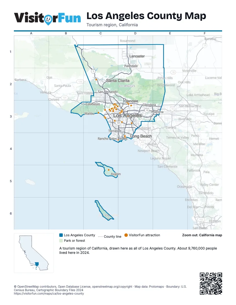
Highway index of Los Angeles County
Each highway on the sheet and the grid squares it crosses.
- I-5B1, C1, C2, C3, D3
- I-10C3, D3, E3
- I-105C3, D3
- I-110D3, D4
- I-210C2, D2, D3
- I-405C2, C3, D3, D4
- I-605D3
- I-710D3, D4
- US 6D3
- US 66D3
- US 99B1, C1, C2, D3, E3
- US 101B3, C3, D3
- CA 1B3, C3, D4
- CA 2C3, D2, D3
- CA 14C2, D1, D2
- CA 18E2
- CA 22D4
- CA 47D4
- CA 57D3, E3
- CA 60D3, E3
- CA 71E3
- CA 90C3
- CA 91D3
- CA 103D4
- CA 110D3
- CA 118C2
- CA 126C2
- CA 134C3, D3
- CA 138B1, C1, D1, D2, E2
- CA 170C2, C3
- CA 210D3, E3
- CA 710D3
Things to do on the Los Angeles County map
- Academy Museum of Motion Pictures
- Amoeba Music Hollywood
- Angels Flight Railway
- Antelope Valley Mall
- Aqua Surf School
- Aquarium of the Pacific
- Bembridge House
- Beverly Center
- Bicycle Casino
- Burbank Town Center
- California Parasail Catalina Island
- Catalina Adventure Tours
- Catalina Island
- Catalina Island Horseback Adventures
- Catalina Museum for Art & History
- Catalina Sea Spa
- Catalina Tour Guide
- Chateau Marmont
- Citadel Outlets
- Commerce Casino & Hotel
- Crypto.com Arena
- Del Amo Fashion Center
- Dodger Stadium
- Dolby Theatre
- Eric's on the Pier
- Getty Villa
- Glenmore Plaza Hotel
- Golf N' Stuff
- Grand Central Market
- Greek Theatre
- Griffith Observatory
- Griffith Park
- Haunted Catalina Ghost Tour
- Hollywood Bowl
- Hollywood Bus Tours
- Hollywood Pantages Theatre
- Hollywood Sign
- Hollywood Walk of Fame
- Hotel Metropole
- Immersed Catalina
- Island Water Charters Parasailing
- La Brea Tar Pits
- Los Angeles County Museum of Art (LACMA)
- Malibu Country Mart
- Manhattan Village
- Maverick Helicopters Long Beach
- Melrose Trading Post
- Natural History Museum of Los Angeles County
- Old Pasadena
- Olvera Street
- Original Farmers Market & The Grove
- Ovation Hollywood
- Paramount Studio Tour
- Petersen Automotive Museum
- Ripley's Believe It or Not Hollywood
- Rodeo Drive
- Rose Bowl Stadium
- Sherman Oaks Galleria
- SoFi Stadium
- Sunset Strip
- TCL Chinese Theatre
- The Americana at Brand
- The Beverly Hills Hotel
- The Broad
- The Comedy Store
- The Commons at Calabasas
- The Getty Center
- The Huntington Library, Art Museum, and Botanical Gardens
- Universal Studios Hollywood
- Venice Beach Boardwalk
- Walt Disney Concert Hall
- Warner Bros. Studio Tour Hollywood
- Watts Towers
- Westfield Century City
- Whisky a Go Go
Places on the map
- Avalon
- Calabasas
- Glendale
- Glendora
- Lancaster
- Long Beach
- Los Angeles
- Malibu
- Palmdale
- Pomona
- Rancho Palos Verdes
- San Fernando
- Santa Clarita
- Torrance
Next to Los Angeles County
- Central Coast map
- Central Valley map
- Inland Empire
- Orange County map
© OpenStreetMap contributors, Open Database License, openstreetmap.org/copyright · Map data: Protomaps · Boundary: U.S. Census Bureau, Cartographic Boundary Files 2024