

California map
Chowchilla map
About 19,191 people live here (Census Bureau, 2024 estimate). The sheet's index lists 234 streets; Robertson Boulevard, South 13th Street and South 14th Street cross the most grid squares. Also on it: Pheasant Run Golf Club, Valley State Prison and Central California Women's Facility.
Open the map (PDF, US Letter)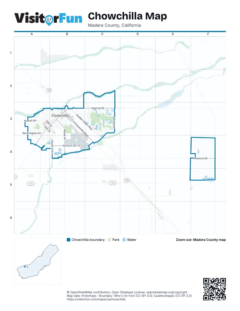
Street index of Chowchilla
Each street on the sheet and the grid squares it crosses.
- Fallen Leaf WayC2, C3
- Acacia CourtA3
- Almond CourtA3
- Amador StreetA3
- Autumn WayA3
- Birch CourtA3
- Blossom DriveA3
- Calaveras StreetA3, B3
- Califa DriveA3
- Camellia DriveA3
- Canal DriveA3
- Cedar CourtA3
- Charlene DriveA3
- Cherry CourtA3
- Cherry WayA3
- Chestnut DriveA3
- Circle DriveA3, B3
- Cottonwood DriveA3
- Cristen StreetA3
- Cypress LaneA3
- Danielle StreetA3
- Deborah WayA3
- Dorothy WayA3
- Elm AvenueA3
- Englewood AvenueA3
- Gill WayA3
- Holiday WayA3
- Hoover AvenueA3, A4
- Hospital DriveA3
- Howell RoadA3
- Humboldt AvenueA3, B3
- Juniper CourtA3
- Kings AvenueA3, B3
- Kites WayA3
- Lake AvenueA3, B3
- Larkin AvenueA3
- Magnolia CourtA3
- Maple StreetA3
- Michelle CourtA3
- Molly AvenueA3
- Monterey AvenueA3, B3
- North 10th StreetA3, B3
- North 11th StreetA3
- North 12th StreetA3
- North 13th StreetA3
- North 14th StreetA3
- North 15th StreetA3
- North 5th StreetA3, B3
- North 6th StreetA3, B3
- North 7th StreetA3, B3
- North 8th StreetA3, B3
- North 9th StreetA3, B3
- Oak CourtA3
- Orange AvenueA3, B3
- Park Ridge CourtA3
- Park Ridge DriveA3
- Peach CourtA3
- Peach DriveA3
- Penny StreetA3
- Phillip CourtA3
- Phillip WayA3
- Pine CourtA3
- Pine StreetA3
- Pistachio CourtA3
- Plum CourtA3
- Plum WayA3
- Riverside AvenueA3, B3
- Road 15A3
- Robertson BoulevardA3, B3, A4
- Roosevelt DriveA3, A4
- Rose AvenueA3
- Rosehill DriveA3
- Santa Cruz BoulevardA3
- Sonoma AvenueA3, B3
- South 11th StreetA3, B3
- South 13th StreetA3, B3, B4
- South 14th StreetA3, B3, B4
- South 15th StreetA3, A4, B4
- Spruce CourtA3
- Thomas Chidlaw DriveA3
- Trinity AvenueA3, B3
- Ventura AvenueA3, B3
- Walnut WayA3
- Washington RoadA3
- Willow CourtA3
- Airport DriveB3, B4
- Alameda AvenueB3, A4, B4
- Alma CourtB3
- Auto Park DriveB3
- Avenue 25B3
- Avenue 26B3, C3
- Bidan AvenueB3, C3
- Carlyle WayB3
- Chowchilla BoulevardB3
- Colusa AvenueB3, B4
- Conadria AvenueB3, C3
- Cordelia AvenueB3, C3
- East Robertson BoulevardB3
- Golden State HighwayB3, C3, C4
- Mariposa AvenueB3, B4
- Mariposa RoadB3
- Mission AvenueB3
- Montgomery Lake WayB3, C3
- North 1st StreetB3
- North 2nd StreetB3
- North 3rd StreetB3
- North 4th StreetB3
- North Front StreetB3
- Road 16B3, B4
- Road 16 1/2B3, B4
- South 10th StreetB3
- South 12th StreetB3
- South 1st StreetB3
- South 2nd StreetB3
- South 3rd StreetB3
- South 4th StreetB3
- South 5th StreetB3
- South 6th StreetB3
- South 7th StreetB3
- South 8th StreetB3
- South 9th StreetB3
- South Chowchilla BoulevardB3, C4
- South Front StreetB3
- South Genoa Lake WayB3
- South Lake Tahoe DriveB3, C3
- Verte StreetB3
- West Front StreetB3
- West Kings AvenueB3
- West Mariposa AvenueB3
- AmalfiC3
- Arcadian StreetC3
- Augusta StreetC3
- BassC3
- Bella CorteC3
- Bella Vista StreetC3
- Biltmore StreetC3
- Blackhawk StreetC3
- Brentwood StreetC3
- Broadmore StreetC3
- Camelback StreetC3
- CapriC3
- Cascades StreetC3
- Clubhouse DriveC3
- Como CorteC3
- Congressional StreetC3
- Coronado StreetC3
- Cortina CorteC3
- Deerhurst CourtC3
- Del Monte CourtC3
- Desert Springs StreetC3
- Diablo CourtC3
- Diamond CourtC3
- Doral StreetC3
- Eagle CourtC3
- Echo CourtC3
- Edgewater StreetC3
- Edinburgh StreetC3
- Emerald StreetC3
- Fig Tree BoulevardC3
- Fig Tree RoadC3
- Garda CorteC3
- Gateway WestC3
- Golden Sands WayC3
- Golf Drive WestC3
- Grand Island CourtC3
- Grand Island WayC3
- Granite Falls WayC3
- Hampton StreetC3
- Heatherhurst DriveC3
- Hillsborough WayC3
- Hunters Creek WayC3
- Kaanapali CourtC3
- Kadota AvenueC3
- Kapalua CourtC3
- Keystone DriveC3
- Kingsmill CourtC3
- Kona CourtC3
- Laguna DriveC3
- Lakeshore DriveC3
- Lakeview CircleC3
- Majestic Oaks LaneC3
- Makena DriveC3
- Malibu AvenueC3
- Mallard Cove DriveC3
- Meadow Brook LaneC3
- Mirage DriveC3
- Mission Hills TerraceC3
- Monarch RoadC3
- Monterra LaneC3
- Muirfield RoadC3
- Myrtlewood DriveC3
- Orta CorteC3
- Palisades PlaceC3
- PerchC3
- Pheasant Run BoulevardC3
- Plum Creek WayC3
- Poppy Hills AvenueC3
- Prairie Dunes CircleC3
- Ridgewood WayC3
- Royal Oaks CourtC3
- San MicheleC3
- SorrentoC3
- Spanish Bay WayC3
- Spyglass CircleC3
- SunfishC3
- Tiburon CourtC3
- Tiburon LaneC3
- Torrey Pines CircleC3
- Twin Falls WayC3
- Verdone StreetC3
- VillagioC3
- Adams DriveA4
- Coolidge AvenueA4
- Grant DriveA4
- Harding AvenueA4, B4
- Harrison CourtA4
- Jackson CourtA4
- Jefferson StreetA4
- Kennedy CourtA4
- Lincoln AvenueA4
- Madison CourtA4
- Monroe CourtA4
- Myer DriveA4
- Palm ParkwayA4
- Taft CourtA4
- Truman DriveA4, B4
- Van Buren StreetA4
- Vernal DriveA4
- Washington DriveA4
- Wilson WayA4
- Avenue 24 1/2B4, C4
- Commerce DriveB4
- Road 15 1/2B4
- Avenue 24F4
Places on the map
- A-1 Payday Advance
- A&R Refrigeration
- Ahmed's Exxon
- B&C Tires
- Bank of America
- Canton Restaurant
- Carl's Jr.
- Cathedral of Faith Assembly of God Church
- Central California Women's Facility
- Central Valley Veterinary Clinic
- Chevron
- Chowchilla Airport
- Chowchilla Best Hardware
- Chowchilla Branch Madera County Library
- Chowchilla City Hall
- Chowchilla High School
- Chowchilla Post Office
- Days Inn
- Dollar Tree
- Farnesi's Steakhouse
- Fig Tree Plaza
- Holiday Inn Express & Suites
- Machinery & Equipment Company, Inc.
- Madera County Fairgrounds
- Mario's Mexican Food
- Merle L Fuller Elementary School
- Pheasant Run Golf Club
- R C Wisener Park
- Rite Aid
- Save Mart
- Sports Leisure Park
- Starbucks
- State foods supermarket
- Stephens Elementary School
- SureStay
- Valero
- Valley State Prison
- Veterans Memorial Park
- Wilson Elementary School
© OpenStreetMap contributors, Open Database License, openstreetmap.org/copyright · Map data: Protomaps · Boundary: Who's On First (CC-BY 4.0); Quattroshapes (CC BY 2.0)















