

California map
Madera County map
About 165,432 people live here (Census Bureau, 2024 estimate). The sheet's index lists 300 streets; Golden State Highway, Southern Yosemite Highway and Avenue 12 cross the most grid squares. Things to do inside the boundary: Sierra Vista Scenic Byway.
Open the map (PDF, US Letter)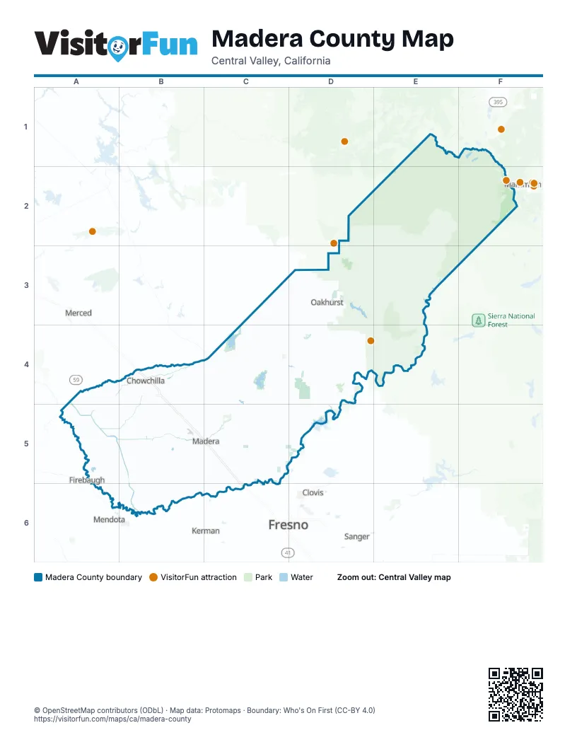
Maps inside Madera County
2 maps inside, from the street map of Madera County down.
Street index of Madera County
Each street on the sheet and the grid squares it crosses.
- Golden State HighwayB4, B5, C5, C6
- Southern Yosemite HighwayD3, D4, C5, D5
- Westbound California State Route 152B4
- SB SR 99 to WB SR 152B4
- NB SR 99 to WB SR 152B4
- NB SR 99 to WB 152B4
- Avenue 23A4, B4, C4
- Avenue 26B4, C4
- South Madera AvenueC5, C6
- Robertson BoulevardB4, A5, B5
- Boot Jack RoadD3
- Road 27C5, C6
- West Olive AvenueB5, C5
- East Yosemite AvenueC5
- South Gateway DriveC5
- East Robertson BoulevardB4
- Los Banos HighwayA4
- Madera AvenueC6
- North Fork RoadD5
- Avenue 12A5, B5, C5, D5
- Road 600C3, D3, C4
- Avenue 20 1/2B4, A5, B5, C5
- Avenue 21A5, B5, C5
- Avenue 7B5, B6, C6
- Avenue 18 1/2A5, B5, C5
- Avenue 14A5, B5, C5
- Avenue 24A4, B4, C4
- Avenue 9A5, B5, C5
- Road 26B4, B5, B6
- Avenue 13B5, C5
- Avenue 20A5, B5
- Road 22B4, B5, B6
- Road 200D4
- Road 222D3, D4, E4
- Road 23B4, B5, B6
- Golden State BoulevardB4, B5, C5, C6
- Avenue 7 1/2A5, B5, C5
- Avenue 10B5, C5
- Road 15B4, B5
- Malum Ridge RoadD3, D4
- Santa Fe DriveB4, C5
- Firebaugh BoulevardB5
- West Cleveland AvenueB5
- Green Mountain RoadC4
- Avenue 27B4
- Road 17 1/2B4, B5
- South Chowchilla BoulevardB4
- Valley Children's PlaceC5
- Sunset AvenueB5, C5
- Raymond RoadC4, C5
- Howard RoadB5
- Road 274D3, D4
- Chowchilla BoulevardB4
- North Gateway DriveB5, C5
- West Yosemite AvenueB5, C5
- West 4th StreetB5, C5
- South Pine StreetB5
- Road 225D4, E4
- Kings AvenueB4
- South Riverwalk BoulevardC5
- West Kennedy StreetB5
- North I StreetB5, C5
- Country Club DriveD3, B5
- Lanes Bridge DriveC5
- North Pine StreetB5
- East Almond AvenueC5
- North H StreetB5, C5
- South H StreetC5
- Avenue 12 (eastbound)C5
- Avenue 12 (westbound)C5
- East Pecan AvenueC5
- Old Avenue 12 Access RoadC5
- Q StreetB5
- South Santa Fe AvenueB4
- 13th StreetA5
- Power House No 1 RoadD4
- North Front StreetB4
- West Kings AvenueB4
- Minarets RoadE2, E3, E4
- Beasore RoadE2, D3, E3
- Sky Ranch RoadE2, D3, E3
- Road 400C4, D4, C5
- Road 16B4, B5, B6
- Avenue 22A4, B4, C4
- Road 29C4, C5, C6
- Avenue 17A5, B5, C5
- Avenue 15B5, C5
- Road 9A4, A5
- Avenue 23 1/2A4, B4
- Road 19B4, B5, B6
- Road 20B4, B5, B6
- Avenue 19A5, B5
- Road 28 1/2C4, C5, C6
- Avenue 11B5, C5, D5
- Avenue 22 1/2A4, B4
- Road 415C4, D4
- Grizzly Meadow RoadE3
- Avenue 21 1/2B4, A5, B5, C5
- Road 28C5, C6
- Road 30C4, C5, C6
- Road 13B4, B5, B6
- Road 36C5
- Road 406C4, D4
- Road 603C4
- Avenue 16B5, C5
- Road 19 1/2B4, B5
- Italian Bar RoadE4
- O'Neals RoadD4, D5
- Road 426D3
- Road 30 1/2C5, C6
- Avenue 24 1/2B4
- Hildreth RoadD4, D5
- Avenue 13 1/2B5, C5
- Teaford Saddle RoadD3, D4
- Fairmead BoulevardB4, B5
- Road 32C5, C6
- Road 210D4, D5
- Road 606C4
- Road 15 1/2B4, B5
- West Pecan AvenueB5, C5
- Road 209C4, C5
- Yosemite Springs ParkwayD4
- Road 602C4
- County Road 29C4, C5
- Ellis StreetB5, C5
- Road 204C5, D5
- Tozer StreetC5
- Road 221D4
- Bass Lake RoadD3
- South Granada DriveB5
- West Root Creek ParkwayC5
- North Lake StreetC5
- North Schnoor StreetB5
- Road 417D4
- Highland DriveD3, D4
- South Riverstone BoulevardC5
- East Cleveland AvenueB5, C5
- North D StreetC5
- West Market AvenueC5
- Kennedy StreetB5
- Indian Springs RoadD3
- Road 35C5, C6
- North Granada DriveB5
- North Shore DriveD3
- Railroad DriveB4, D5
- Southeast Riverstone BoulevardC5
- East Olive AvenueC5
- Austin StreetC5
- Road 28 1/4C5
- Avenue 15 1/2C5
- Road 226D4
- Clinton StreetC5
- Road 34 1/2C5
- Road 208D5
- Road 227E4
- Southwest Riverstone BoulevardC5
- Children's BoulevardC5
- South Monterey BoulevardC5
- South A StreetC5
- West Cardinal BoulevardC5
- Sunrise AvenueC5
- South Shore RoadD3
- Sonora StreetB5
- Westberry BoulevardB5
- Road 37 3/4C5
- Manzanita Lake RoadD4
- South Lodge RoadC5
- South Mission DriveC5
- Creekside DriveC5, D5
- Preserve DriveD5
- East Sherwood WayB5, C5
- Avenue 10½C5
- Goodwin WayC5
- Peck BoulevardC5
- El Camino RoadC5
- Avenue 11 1/4B5, C5
- Clark StreetB5
- Hanover DriveB5
- Sharon AvenueB5
- South I StreetC5
- East Kennedy StreetC5
- Road 211D4
- Roosevelt StreetC5
- Road 27 3/4C5
- South 5th StreetB4
- River Parkway RoadD3
- Wildflower Drive Road 204D5
- Sherwood StreetB5
- East 9th StreetC5
- Root Creek ParkwayC5
- South Knox RoadC5
- Schnoor StreetB5
- Market RoadC5
- Enchanted HIlls DriveD5
- South Schnoor StreetB5
- Sugar Pine DriveD5
- Road 432D3
- Market AvenueC5
- Road 204 Enchanted HIlls DriveD5
- Cypress StreetB5
- Lane's BridgeC5
- Crocket WayC5
- Ben Hur RoadC4
- Road 21B4, B5, B6
- Central Camp RoadD3, E3
- Road 24B4, B5, B6
- Avenue 18A5, B5, C5
- Avenue 6A6, B6, C6
- Bailey Flats RoadC3, C4
- Avenue 8B5, C5
- River RoadC4, C5
- Avenue 19 1/2A5, B5, C5
- Road 14B4, B5
- Avenue 17 1/2A5, B5, C5
- Road 10A4, A5
- Road 8A4, A5, A6
- Road 18B4, B5
- Avenue 14 1/2A5, B5, C5
- County Road 235D4, E4
- Road 18 1/2B4, B5
- Road 12B4, B5
- Forest Route 5S30E2
- Eastside DriveA6, B6
- Road 21 1/2B4, B5, B6
- Road 11B4, B5
- Buchanan RoadC4, B5
- Road 29 1/2C4, C5, C6
- Avenue 25A4, B4
- Avenue 5B6, C6
- Veater Ranch RoadD3, D4
- Road 24 1/2B5, B6
- Avenue 5 1/2B6, C6
- Avenue 16 1/2B5, C5
- Whiskey Falls RoadE3, E4
- Road 20 1/2B4, B5
- Road 33C5, C6
- Avenue 8 1/2A5, B5, C5
- Road 6A4, A5
- Road 207C4, D4
- Road 620D3
- Mammoth Pool RoadE3
- Road 26 1/2C5, C6
- Wyle Ranch RoadD4
- Road 23 1/2B4, B5
- Beasore Loop RoadD3, E3
- Minaret Summit RoadF2
- Road 7A4, A5, A6
- Road 612C3, C4
- Road 4A4, A5
- Chowchilla Canal RoadB5, B6
- Road 411C4
- Sugar Pine RoadD3
- Road 5 1/2A4, A5
- Flying O Ranch RoadD4
- Road 17B4, B5
- Potter Ridge Fire RoadD3
- Road 33 1/2C5
- Avenue 12 1/2B5, C5
- Douglas Ranger Station RoadD3, E3, E4
- Avenue 11 1/2B5, C5
- Lilley Mountain DriveC4, D4
- Road 8066D4
- Road 420D3
- Road 628D3
- 5S04E2
- 6S41D3
- Road 38C5
- Road 810C3
- Road 37C5
- South Granada Drive / Road 25B5, B6
- Sierra Oaks LaneD4
- Three Gate RoadD4
- Road 407C4
- Mill Canyon RoadD3
- Mammoth Powerhouse RoadE4
- Sivels Ranch RoadD3
- 5S18D3
- Road 31C5, C6
- Rabbit HillC4
- 6S24D3
- Avenue 25 1/2A4, B4
- Road 22 1/2B4, B5
- Road 39 1/2C5
- Road 8009E4
- Melvin RoadD3, D4
- Road 40C5
- Wide Awake Ranch RoadC5
- River Knolls RoadC4, D4
- Road 25B5, B6
- Road 14 1/2B4, B5
- Cascadel RoadE4
- Spangle Gold RoadC4
- 6S17D3
- Opah DriveD3
- Longview Lane EastD4
- Corrine Lake RoadD4, E4
- Avenue 26 1/2B4
- Lazy L Summit RoadD3
- Road 812C3
- Long Hollow DriveC4, D4
Things to do on the Madera County map
Places on the map
- Ahwahnee Hills Loop
- Ahwahnee Hills Regional Park
- Ansel Adams Wilderness
- Arnold Meadow
- Bass Lake
- Beasore Meadows
- Black Hawk Lake
- Cassidy Meadows
- Chowchilla
- Garnet Lake
- Graveyard Meadow
- H. V. Eastman Lake
- Headquarters Meadow
- Hensley Lake
- Hidden Lake Recreation Area
- Jackass Meadow
- Kennedy Table
- Kerckhoff Lake
- Kinsman Flat Wildlife Area
- Lodge District
- Long Meadow
- Madera
- Madera Acres
- Madera County Fairgrounds
- Madera Equalization Reservoir
- Madera Lake
- Madera Municipal Airport
- Madera Municipal Golf Course
- Millerton Lake
- Millerton Lake Campground
- Millerton Lake State Recreation Area
- Nelder Grove
- Nelder Grove Historical Area
- Oakhurst
- Parksdale
- Parkwood
- Pheasant Run Golf Club
- San Joaquin Experimental Range
- San Joaquin River
- Whisky Snowmobile Area
Next to Madera County
- Atwater map
- Clovis map
- Firebaugh
- Fresno map
- Kerman map
- Mammoth Lakes
- Mendota map
- Merced map
- Sanger map
© OpenStreetMap contributors, Open Database License, openstreetmap.org/copyright · Map data: Protomaps · Boundary: Who's On First (CC-BY 4.0); Quattroshapes (CC BY 2.0)















