

California map
Costa Mesa map
About 109,131 people live here (Census Bureau, 2024 estimate). The sheet's index lists 300 streets; Costa Mesa Freeway, San Diego Freeway and Newport Boulevard cross the most grid squares. Things to do inside the boundary: South Coast Plaza.
Open the map (PDF, US Letter)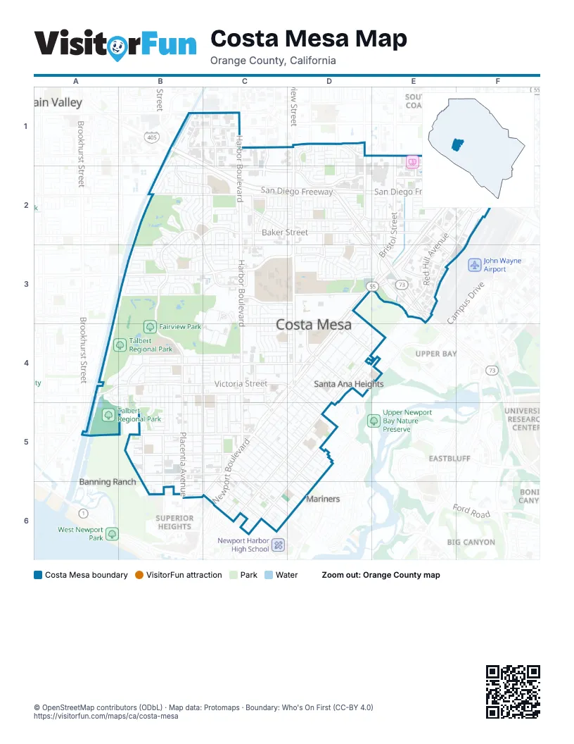
Street index of Costa Mesa
Each street on the sheet and the grid squares it crosses.
- Costa Mesa FreewayE2, F2, D3, E3, C4, D4, C5
- San Diego FreewayB1, C1, C2, D2, E2, F2
- Corona Del Mar FreewayD2, E2, E3
- I 405 N HOVF1, E2, F2
- Harbor BoulevardC1, C2, C3, C4, C5
- Newport BoulevardD3, E3, C4, D4, C5, C6
- Bristol StreetE1, E2, E3
- Adams AvenueB3, C3, D3
- Presidio DriveD3, E3
- Southeast Bristol StreetE3
- Main StreetF1, F2
- Fairview RoadD1, D2, D3, D4
- Placentia AvenueB3, B4, B5, B6
- Baker StreetB2, C2, D2, E2, B3, E3
- South Coast DriveC2, D2
- Red Hill AvenueE2, F2, E3
- Victoria StreetA4, B4, C4, D4
- West 19th StreetB5, C5
- Paularino AvenueD2, E2, F2, F3
- Bear StreetD1, D2, D3, E3
- Fair DriveD3, C4, D4
- East 17th StreetC5, C6
- West Sunflower AvenueC1, D1, E1
- Irvine AvenueD4, E4, D5, D6
- BroadwayC5, D5, D6
- 22nd StreetD4, D5
- Superior AvenueC5, C6
- Del Mar AvenueD4, E4
- North University DriveE4
- South Bear StreetD1
- Fairview StreetD4
- South Fairview StreetD1
- Hamilton AvenueA4
- Santa Ana AvenueE3, D4, E4, C5, D5, C6
- West Wilson StreetB4, C4, D4
- Anton BoulevardF1, E2, F2
- Westminster AvenueD4, C5, D5, C6
- Tustin AvenueD4, D5, C6, D6
- Mesa Verde Drive EastB2, C2, C3
- Merrimac WayC3, D3
- Pomona AvenueB4, B5, C5, C6
- Gisler AvenueB2, C2
- Monrovia AvenueB4, B5, B6
- Mesa Verde Drive WestB2, B3
- West 18th StreetB5, C5
- Airway AvenueF2, E3
- East 16th StreetC5, C6
- Hamilton StreetB4, C4
- Pullman StreetE2, F2, E3
- West 17th StreetB5, C5
- College AvenueC2, C3, C4
- Anaheim AvenueC4, C5
- Arlington DriveD3
- East 19th StreetC5, D5, D6
- Meyer PlaceC4, C5
- California StreetB1, B2, C2
- Randolph AvenueE2, E3
- Whittier AvenueB5, B6
- Susan StreetC1, C2
- Avenue of the ArtsE1, E2
- Hyland AvenueC1, C2
- Canyon DriveB4
- Santa Isabel AvenueD4
- West 16th StreetB6, C6
- West Bay StreetC5
- El Camino DriveD3
- Watson AvenueC2
- Mendoza DriveD2, D3
- Sakioka DriveE1, E2
- Scenic AvenueB1, C1
- Junipero DriveD3
- East Wilson StreetD4
- East Bay StreetC5, D5
- Maple AvenueC4, C5
- Wimbledon WayD1, D2
- Killybrooke LaneC2
- Kalmus DriveE3
- Vanguard WayD3, D4
- Airport Loop DriveF2
- Cadillac AvenueB1
- Belfast AvenueC2, D2
- Bernard StreetC5
- Loren LaneC2, D2
- Sunflower AvenueB1, C1
- Mesa DriveD3
- Peterson PlaceC3
- Thurin AvenueC4, C5
- Baker Street EastE3
- Industrial WayC6
- Garlingford StreetC2
- Santiago DriveD5
- Vista WayE1, E2
- Gregory WayC3
- Greenbrook DriveD2
- Wilson StreetD4
- 19th StreetB5
- Orange AvenueD4, C5, D5, C6
- Elden AvenueD3, D4, C5, D5
- Center StreetC4, B5, C5
- Joann StreetB4, C4
- Iowa StreetB2, C2
- Wallace AvenueB4, B5
- East 20th StreetC5, D5
- Flower StreetC5, D5, D6
- East 18th StreetC5, D6
- Magnolia StreetC5, D6
- Cabrillo StreetC5, C6
- Costa Mesa StreetC5, D5, D6
- North Shelly CircleC3, B4, C4
- Park Center DriveE1, E2
- Fullerton AvenueC5
- Monte Vista AvenueD4, E4
- 16th PlaceC6
- East 21st StreetC5, D5
- Fordham DriveC3, C4
- Federal AvenueB4, B5
- Princeton DriveC3, D3
- Continental AvenueB4, B5
- Village WayC3, D3
- Congress StreetB4, C4
- Rochester StreetC5, C6
- Country Club DriveB2
- Esther StreetC5, D5
- Ogle StreetC6
- Walnut StreetC5, D5
- 23rd StreetD4
- National AvenueB4, B5
- Columbia DriveC3, D3, C4, D4
- Governor StreetB4, C4
- Royal Palm DriveC2, C3
- Raymond AvenueC5, D5, C6
- Darrell StreetB4, C4
- Cheyenne StreetD2
- Enclave CircleE1, E2
- Mission DriveD3
- Sterling AvenueB4, B5
- Republic AvenueB4, B5
- Samar DriveB3, C3
- Palace AvenueB4, B5
- Cecil PlaceD4, D5
- Virginia PlaceD4, D5
- Albert PlaceD4, D5
- Avocado StreetC4, D4
- Club House RoadB2, B3
- Bucknell RoadC3
- Pacific AvenueA4, B4
- Buckingham DriveD2
- Andros StreetC2, C3
- Tanager DriveB3, C3
- New Hampshire DriveB1, B2, C2
- Fairway DriveD4
- Golf Course DriveC3
- Java RoadB2, B3
- Sonora RoadD3
- Villanova RoadD3, C4, D4
- Coolidge AvenueD2
- Wake Forest RoadC4, D4
- Balearic DriveB3
- Coronado DriveD3
- Tahiti DriveB2, B3
- Rutgers DriveC4
- Oak StreetB4
- Swan DriveB3
- Valley ForgeD4
- Oriole DriveB3
- Madeira AvenueB2
- Conway AvenueC2, D2
- Fuchsia StreetD1, D2
- Logan AvenueC2
- West 20th StreetB5
- Gibraltar AvenueC2
- Fischer AvenueE3
- Traverse DriveE2
- Hanover DriveC3, D3
- Manistee DriveE2
- Aliso AvenueD5, C6
- Maple StreetC4
- Yukon AvenueD2
- Labrador DriveB2, C2
- Ponderosa StreetC3
- Capitol StreetB4, C4
- Charle StreetC4, C5
- Drake AvenueD3
- Arbor StreetB5
- Senate StreetB4, C4
- Ellesmere AvenueB3
- Hummingbird DriveB3
- Salinas AvenueD2
- Warren LaneC2
- Begonia AvenueD1
- Boa Vista DriveB3
- Parsons StreetC4, C5
- Samoa PlaceB2, C2
- Raleigh AvenueB4
- Pierpont DriveE2
- Miner StreetC4
- Pitcairn DriveB3
- Loyola RoadC3, C4, D4
- College DriveC4
- Tulare DriveD2
- Sturgeon DriveE2
- Nassau RoadC4
- Saint Clair StreetD3, E3
- Flamingo DriveB3
- Shalimar DriveB5, C5
- State AvenueB4, B5
- Elm AvenueC3
- Cornell DriveC4
- Colgate DriveC4
- Magellan StreetD3
- Europa DriveB3
- Smalley RoadD1, D2
- San Juan LaneD3
- Kinglet CourtB3
- Minorca DriveC3
- McCormick AvenueE2, F2
- Santa Catalina DriveC3
- Azalea DriveD1
- Van Buren AvenueD2
- Lorenzo AvenueD3
- Minnesota AvenueB2
- Ludington StreetE2
- Babb StreetD2
- Pemba DriveB2, B3
- Washington AvenueB2
- Phalarope CourtB3
- Corsica PlaceC2
- Technology DriveC3
- PinecreekC3
- Coriander DriveC2
- Stromboli RoadB3
- Dakota AvenueB2
- Ceylon RoadB2
- Norse AvenueD4
- Caraway DriveC2
- Brioso DriveB5
- Barbados PlaceB2, C2
- Peppertree LaneC2, C3
- Albatross DriveB3
- Church StreetC5
- Pearl WayC4
- Santa Clara CircleD1, D2
- Jacaranda AvenueC2, C3
- Cinnamon AvenueC2
- Londonderry StreetC2, D2
- Babcock StreetB5, B6
- Donnybrook LaneC2
- Yellowstone DriveE2
- Fernheath LaneC2
- Harbor Gateway SouthC1
- Park AvenueC5
- Camellia LaneD5
- Rose LaneD5
- Sierks StreetC5, D5
- Knox StreetC6
- Towne StreetB5
- Knox PlaceC6
- Murray LaneC2
- Palmer StreetC6
- Plumer StreetB5, C5
- Capri LaneB2
- Ford RoadC5
- Michigan AvenueC2
- Carnegie AvenueC3, C4
- Palau PlaceC2, B3, C3
- La Salle AvenueD3
- Carnation AvenueD1
- Monitor WayC3, D3
- Anacapa DriveC3
- Union AvenueB4
- Brentwood StreetD4
- West Wakeham PlaceD1
- Redwood AvenueC2, C3
- Presidio SquareD3
- Back Bay LoopD4, E4
- Bermuda DriveB2
- Corona LaneD3
- Linden PlaceB4
- Valley RoadA4, B4, B5
- Bowling Green DriveC3
- Dorset LaneD2
- Clinton StreetE3
- Nevada AvenueB1
- Newport Frontage RoadC6
- Cibola AvenueD3
- Valencia StreetD3
- Velasco LaneD3
- Arnold AvenueC5
- Club House CircleB2, B3
- Kincaid DriveC3
- Dahlia AvenueD2
- Salvador StreetD3
- Avalon StreetC4
- Mark LaneC3
- Loreto AvenueD3
- Ceylon DriveB2, B3
- President PlaceB4, B5
- Sea Bluff DriveA4, B4
- Emerson StreetD5
- Serang PlaceB3, C3
Things to do on the Costa Mesa map
Places on the map
- 17th Street Promenade
- Adams Elementary School
- Avenue of the Arts Costa Mesa
- Ayres Hotel
- Back Bay High School
- Best Buy
- Bloomingdale's
- Canyon Park
- Chipotle
- Christ Lutheran Church
- Citibank
- College Hospital Costa Mesa
- Costa Mesa City Hall
- Costa Mesa Country Club
- Costa Mesa Courtyards
- Costa Mesa Fire Station 3
- Costa Mesa High School
- Costa Mesa Marriott
- Costa Mesa Square
- Costal Heights Senior Living
- Crowne Plaza Costa Mesa OC
- Davis Magnet School
- Early College High School
- Estancia High School
- Estancia Park
- Fairview Park
- Fairview Wetlands
- First United Methodist Church
- Harbor Shopping Center
- Macy's Home Furniture
- Mesa Verde Country Club
- Metro Pointe at South Coast
- Orange County Fair and Events Center
- Santa Ana River
- Segerstrom Hall
- SoCal Youth Center of Orange County
- South Coast Plaza
- Talbert Regional Park
Next to Costa Mesa
- Banning Ranch
- Belcourt
- Big Canyon
- Bonita Canyon
- Dover Shores
- Eastbluff
- Fountain Valley map
- Harbor Cove
- Harbor Heights
- Harbor View
- Mariners
- Newport Heights
- Newport North
- Newport Shores
- One Ford Road
- Santa Ana Country Club
- South Coast
- South Mesa
- Superior Heights
- Talbert
- The Bluffs
- The Plaza
- University Research Center
- Upper Bay
- Westcliff
© OpenStreetMap contributors, Open Database License, openstreetmap.org/copyright · Map data: Protomaps · Boundary: Who's On First (CC-BY 4.0); Quattroshapes (CC BY 2.0)















