

California map
Fairfield map
About 122,646 people live here (Census Bureau, 2024 estimate). The sheet's index lists 300 streets; Dwight D. Eisenhower Highway, Air Base Parkway and Bridle Ridge Drive cross the most grid squares. Things to do inside the boundary: Jelly Belly Visitor Center.
Open the map (PDF, US Letter)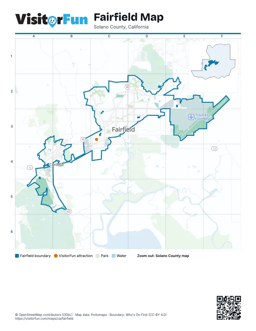
Street index of Fairfield
Each street on the sheet and the grid squares it crosses.
- Dwight D. Eisenhower HighwayC2, C3, A4, B4, A5
- Luther E Gibson FreewayB4, B5
- Air Base ParkwayC2, D2, E2, D3, E3
- Peabody RoadE2
- Waterman BoulevardC2, C3
- Walters RoadD2, D3
- Business Center DriveA4, B4
- North Texas StreetC2, D2, C3
- Lopes RoadA4, A5, B5
- Manuel Campos ParkwayC2, D2
- Hilborn RoadC2
- Pennsylvania AvenueC2, C3
- Paradise Valley DriveD2
- Cordelia RoadA4, B4, C4
- Cement Hill RoadC2, D2, E2
- Travis BoulevardC3
- Gold Hill RoadA5, B5
- East Tabor AvenueC3, D3
- Green Valley RoadA4, B4
- Dover AvenueD2, E2, D3
- Red Top RoadA4
- Chadbourne RoadB3, C3, C4
- Beck AvenueC3, C4
- Travis AvenueE2, E3
- Suisun Valley RoadB3, B4
- Oliver RoadC3
- Texas StreetE2, C3
- West Texas StreetC3
- Neitzel RoadA4, B4
- East Travis BoulevardC3, D3
- Pittman RoadB4
- Sunset AvenueD3
- Railroad AvenueD3
- Rockville RoadC3
- Suisun ParkwayB3, B4
- Clay Bank RoadD2, D3
- Rancho Solano ParkwayC2, C3
- Mangels BoulevardA4, B4
- Dickson Hill RoadC2, D2
- Saint Andrews RoadC2
- Courage DriveC3
- Union AvenueC2, C3
- Ragsdale StreetE2, E3
- Woolner AvenueC3
- Webster StreetC3
- Gateway BoulevardC3
- Auto Mall ParkwayC3
- McGary RoadA4, A5
- Burgan BoulevardE2, E3
- Central WayB4
- Lyon RoadC2
- Westamerica DriveB4
- 5th StreetC3
- Atlantic AvenueC2
- Woodcreek DriveC3
- Jackson StreetC3
- Mankas Corner RoadC3
- Solano College RoadB3, B4
- Kaiser DriveB4
- Acacia StreetC3
- Cadenasso DriveC3
- West Cordelia RoadA4
- Central PlaceB4
- Guittard WayB3, C3
- Meyer WayC3
- North Gate RoadE2
- Healthcare DriveA4
- Bridgeport AvenueA4, B4
- Perimeter RoadF2, E3, F3
- Gulf DriveD2
- Hangar AvenueE3
- Ellis DriveE3
- Collins DriveE2, F2
- Peppertree DriveD2
- Meadowlark DriveD3
- Marigold DriveC2, D2
- Utah StreetC3
- Pebble Beach CircleB2, C2
- Hickam AvenueE3
- 1st StreetE2, C3, E3
- Vista GrandeC2, C3
- Broadway StreetE2, C3, E3
- Fairfield AvenueC2, C3, E3
- Twin Peaks DriveE2, E3
- Kentucky StreetE2, C3
- Joseph Gerevas DriveD2, E2
- Oakbrook DriveA4, A5
- Huntington DriveD2, E2
- Martin RoadC2
- Antiquity DriveA4
- Bodin CircleE3
- Dixon AvenueE3
- Bridle Ridge DriveA3, B3, A4, B4
- Parker RoadE2, E3
- Quail DriveD3
- Northwood DriveA5, B5
- Lakeshore DriveA4
- Constitution AvenueD2
- Empire StreetC3
- Palmer CircleC2
- Wyoming StreetE2, C3
- Tabor AvenueC3
- Airlift DriveE2, F2, E3, F3
- East Atlantic AvenueD2
- Dynasty DriveA4
- Jefferson StreetC3
- Scott StreetE2, D3, E3
- South Watney WayC3, C4
- Hancock DriveD2, E2
- Cannon DriveE2
- Armstrong StreetE2
- Goya DriveC2
- Holiday LaneC3
- Clay StreetC3
- Vandenberg DriveF2, F3
- North Watney WayC3
- Alaska AvenueC2, C3
- Astoria DriveC3
- Barbour DriveC3
- Hickory AvenueD2
- Creed RoadE3
- Delaware StreetE2, C3
- Gramercy CircleE2
- Fieldcrest AvenueC2
- Orchid StreetC2
- Bel Air CircleD3
- Avondale CircleD2
- Sanctuary DriveC2
- Bradley BoulevardE2
- Busch DriveB3, C3
- Kansas StreetE2, C3
- Mankas BoulevardC3
- Hillridge DriveC2
- X StreetE3
- Elmhurst CircleD2
- Minnesota StreetC3
- Peach Tree DriveC3
- Capitola WayC3
- East Pacific AvenueC3, D3
- Madison StreetC3
- Link RoadB4
- Vintage Valley DriveA4
- Cherry Valley CircleC2
- Dartmoor CircleA5, B5
- 2nd StreetC3
- Fermi RoadA4
- Seminole CircleC2
- Washington StreetC3
- Pavilion DriveA4
- Quail Hollow DriveC2
- Watt DriveA4
- Huck RoadD2, E2
- East Tennessee StreetC3, D3
- Taft StreetC3, D3
- Pacific AvenueC3
- Silverado DriveA4, A5
- Oakridge DriveA3, B3, A4
- Nightingale DriveD2, D3
- Enterprise DriveC3
- Linden AvenueD2
- Dahlia StreetC2
- Michigan StreetE2, C3
- Ellis Godfrey DriveD2, E2
- Thomasson LaneB4
- The Masters DriveD2
- Digerud DriveE2
- Canyon Hills DriveB5
- Horizon CircleD2
- Mustang CircleD2
- Mountain Meadows DriveB4
- Eastridge DriveA3, A4
- Horizon DriveD2
- Baker DriveF2
- Redwood DriveD2
- Begonia BoulevardC2
- New Jersey StreetC3
- Shaker Run CircleD2
- A StreetE2, F2
- Great Jones StreetC3
- Taylor StreetC3
- Maine StreetE2
- Rollingwood DriveC2
- East Alaska AvenueD2, C3, D3
- Hom DriveD2, E2
- German StreetB2, C2
- Lakeview CircleA5
- Cunningham DriveC2, E2, C3
- San Jose StreetD3
- Buckingham DriveC3
- Springfield DriveC3
- Diablo DriveE2
- Danbury WayD2
- Kidder AvenueD3
- Ohio StreetC3
- Brittany DriveA4, A5
- Gregory StreetC3
- Highland CircleA5, B5
- Water Works LaneE2
- Dobe LaneE2
- Maryland StreetC3
- Tunner DriveE2
- Seminole DriveC2
- Silver Lake DriveA4, A5
- De Ronde DriveE2
- Autumn Meadow DriveB5
- Hummingbird DriveB5
- Emerald Bay DriveA4
- Penn Creek DriveC2
- Bay Tree DriveD2
- Silver Fox CircleC2
- Falcon DriveD3
- Grande CircleD3
- Citrine CircleB4
- Fairchild DriveE2
- Fulton DriveA4
- Heath DriveC2, C3
- Rasmussen WayD2, E2
- Burbank DriveC3
- Knoll DriveB3, B4
- Kolob DriveC3
- Cormorant DriveD3
- Missouri WayE2
- Shelby DriveC3
- Sanderling DriveD3
- Candleberry WayD2
- Vintage AvenueA5, B5
- Chuck Hammond DriveE2
- Illinois StreetE2, C3
- Ten Gate RoadC2, C3
- Cordelia AvenueE3
- Norwalk PlaceC3
- Bianco CircleA4
- Owens StreetC3
- Evergreen DriveD2
- James StreetC3
- Missouri StreetC3
- Summerset DriveB5
- Larchmont CircleC3
- Boothey AvenueE2, F2
- Hamilton StreetE2
- Burgundy WayC3
- W. R. Glusen DriveE2
- Julia Berger CircleA4
- Shoreline CircleD2
- Solano Foothills DriveC2
- East Colorado StreetD3
- Estates DriveD2
- Skymaster WayE2, E3
- Sunrise DriveD2
- Camrose AvenueD2
- Puffin CircleE2
- Balance CircleD2
- Baltic DriveD2
- Ridgefield CircleA5, B5
- Phoenix DriveD3
- Sanctuary CircleC2
- Couples CircleD2
- Davis DriveD3
- Coolidge StreetD3
- Astoria CircleC3
- Calaveras DriveC3
- Walker DriveE2
- Strassberger DriveD2
- Mystic DriveD2
- Wailea CircleC2
- Oregon StreetE2, C3
- Hamilton DriveC3
- Saddlebred DriveB5
- Crocker CircleD2
- Greenfield DriveC2
- Cambridge DriveC3
- Walters CourtD3
- San Marco StreetD3
- Oakwood DriveB3, B4
- Nevada StreetE2, C3
- San Remo StreetD3
- Hilton Head DriveC2
- Eisenhower StreetD3
- Petersen RoadE3
- High Line DriveD2
- Americano WayD2
- Tulip StreetC2
- C StreetE3
- Fox Glen DriveC2
- Del Monte DriveC2
- Idaho StreetE2, C3
- Oakbrook CircleA5
- Rowe DriveE2
- Pecan CircleD2
- Brookdale CircleA5
- Gold Coast DriveD2
- Blossom AvenueD3
- Nantucket DriveC3
- W StreetE3
- Capricorn CircleD2
- Cherry Valley DriveC2
- Bickford CircleE2
- Tuscany DriveA4
- Potrero WayC3
- Norton StreetE2
Things to do on the Fairfield map
Places on the map
- Allan Witt Park
- Anheuser-Busch InBev Plant
- Armijo High School
- B. Gale Wilson K-8 School
- Center Elementary School
- Cleo Gordon Elementary School
- Cordelia Community Park
- Cordelia Plaza
- Costco
- Fairfield Auto Mall
- Fairfield Center
- Fairfield Civic Center
- Fairfield Corners
- Fairfield Corporate Commons
- Fairfield High School
- Fairfield-Suisun Adult School
- Gary Falati Neighborhood Park
- Grange Middle School
- Green Valley Corporate Park
- Green Valley Crossing
- Green Valley Lake
- Green Valley Middle School
- Green Valley Office Park
- Highland Commercial Center
- Holiday Galleria
- Jelly Belly Tours
- Laurel Creek Elementary School
- Laurel Creek Park
- Linear Park
- Linear Park Trail
- McCoy Basin
- Meadow Park
- NorthBay Medical Center
- Octo Inn Soccer Complex
- Paradise Valley Golf Course
- Rancho Solano Golf Course
- Rodriguez High School
- Solano Town Center
- Spyglass Open Space
- Travis Air Force Base
Next to Fairfield
- Cordelia
© OpenStreetMap contributors, Open Database License, openstreetmap.org/copyright · Map data: Protomaps · Boundary: Who's On First (CC-BY 4.0); Quattroshapes (CC BY 2.0)