

California map
Fresno map
About 550,105 people live here (Census Bureau, 2024 estimate). The sheet's index lists 138 streets; Golden State Highway, West Herndon Avenue and North Marks Avenue cross the most grid squares. Also on it: Airways Golf Course, Arbor Faire and Basin DE.
Open the map (PDF, US Letter)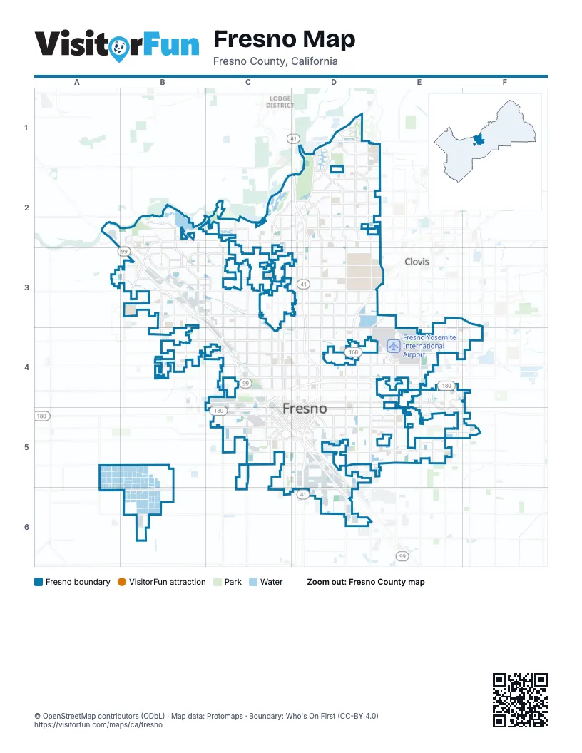
Street index of Fresno
Each street on the sheet and the grid squares it crosses.
- East Copper AvenueD1
- North Friant RoadD1, D2
- North Maple AvenueD1, D2, D4
- North Willow AvenueE1, E2, E3
- Golden State HighwayA2, B3, C3, C4, C5, D5, D6
- North Golden State BoulevardA2, B2, B3
- North Brawley AvenueB2, B3
- North Hayes AvenueB2, B3
- North Milburn AvenueB2, B3
- North Polk AvenueB2, B3, B4
- North Riverside DriveB2, B3
- North Veterans BoulevardB2, B3
- West Herndon AvenueB2, C2, D2, E2, B3
- West Palo Alto AvenueB2, B3
- West Spruce AvenueB2
- North Marks AvenueC2, C3, C4, C5
- North Maroa AvenueC2, C3, C4
- North Palm AvenueC2, C3, C4
- North West AvenueC2, C3, C4
- West Nees AvenueC2, D2
- Dwight David Eisenhower Memorial FreewayD2, D3, D4, D5
- East Alluvial AvenueD2
- East Audubon DriveD2
- East Champlain DriveD2
- East Herndon AvenueD2, E2
- East Minarets AvenueD2
- East Nees AvenueD2, E2
- East Shepherd AvenueD2, E2
- North Blackstone AvenueD2, D3, D4
- North Cedar AvenueD2, D3, D4
- North Chestnut AvenueD2, D4
- North First StreetD2, D3, D4
- North Fresno StreetD2, D3, D4
- North Sommerville DriveD2
- Southern Yosemite HighwayD2
- Yosemite FreewayD2, D5, D6
- North Cecelia AvenueB3
- North Dante AvenueB3
- North Jeanne AvenueB3
- North Marty AvenueB3
- North Weber AvenueB3, C3, C4
- West Ashlan AvenueB3, C3, E3
- West Bullard AvenueB3, C3, D3
- West Figarden DriveB3, C3
- West Shaw AvenueB3, C3, D3, E3
- West Sierra AvenueB3, C3, D3
- East Ashlan AvenueC3, D3, E3
- North Figarden DriveC3
- East Barstow AvenueD3
- East Bullard AvenueD3, E3
- East Shaw AvenueD3, E3
- East Sierra AvenueD3
- North Chestnut DiagonalD3, E3, D4
- Sierra FreewayD3, E3, D4
- North Peach AvenueE3, E4
- West Barstow AvenueE3
- Willow AvenueE3
- West Clinton AvenueB4, C4
- West McKinley AvenueB4, C4
- Divisadero StreetC4, D4
- East Belmont AvenueC4, D4, E4
- East Clinton AvenueC4, D4, E4
- East Madison AvenueC4
- East McKinley AvenueC4, D4, E4
- East Olive AvenueC4, D4, E4
- North Fulton StreetC4
- North H StreetC4
- North Motel DriveC4
- North Parkway DriveC4
- North Van Ness AvenueC4
- North Wishon AvenueC4
- Senator Jim Costa HighwayC4, D4, E4
- Sequoia–Kings Canyon FreewayC4, C5
- South Broadway StreetC4, C5
- Van Ness AvenueC4, C5, D5
- West Belmont AvenueC4
- West Olive AvenueC4
- West Shields AvenueC4, D4
- Abby StreetD4
- East Shields AvenueD4, E4, F4
- East Thomas AvenueD4
- East Tulare AvenueD4, E4
- East Tulare StreetD4, E4
- East Tuolumne StreetD4, C5, D5
- East White StreetD4
- Fresno StreetD4, C5, D5
- M StreetD4, D5
- North 1st StreetD4
- O StreetD4, D5
- P StreetD4, D5
- South 1st StreetD4, D5
- South Blackstone AvenueD4
- South Cedar AvenueD4, D5
- South Chestnut AvenueD4, D5, D6
- South Maple AvenueD4, D5
- Stanislaus StreetD4, C5, D5
- Tulare StreetD4, C5, D5
- U StreetD4
- Clovis AvenueE4
- East Clinton WayE4
- Fowler AvenueE4, E5
- Fresno Yosemite International Airport WayE4
- North Fowler AvenueE4, E5
- North Gateway BoulevardE4
- Peach AvenueE4
- Senator Chuck Poochigian HighwayE4, F4
- South Clovis AvenueE4, E5
- South Peach AvenueE4, E5
- North Temperance AvenueF4, F5
- Temperance AvenueF4
- A StreetC5
- B StreetC5, D5
- BStreetC5, D5
- East Amador StreetC5
- East California AvenueC5
- East Jensen AvenueC5, D5, E5
- East Kearney BoulevardC5
- East Whitesbridge AvenueC5
- South Golden State BoulevardC5, D5
- South Marks AvenueC5
- South Thorne AvenueC5
- Ventura StreetC5, D5
- West Amador StreetC5
- West California AvenueC5
- West Kearney BoulevardC5
- West Whites Bridge AvenueC5
- West Whitesbridge AvenueC5
- C StreetD5
- East Church AvenueD5
- East Jensen Avenue BypassD5
- East Kings Canyon RoadD5, E5
- East Ventura AvenueD5
- Santa Clara StreetD5
- South Elm AvenueD5, D6
- South Fowler AvenueE5
- South Temperance AvenueF5
- East Central AvenueD6
- East North AvenueD6
Places on the map
- Airways Golf Course
- Arbor Faire
- Basin DE
- Belmont Memorial Park
- Bethany Church
- Brian I. Tatarian Grandstand
- California High Speed Rail
Next to Fresno
- Clovis
- Lodge District
© OpenStreetMap contributors (ODbL) · Map data: Protomaps · Boundary: Who's On First (CC-BY 4.0)