

California map
Inglewood map
About 102,774 people live here (Census Bureau, 2024 estimate). The sheet's index lists 300 streets; West Manchester Boulevard, South 3rd Avenue and West Century Boulevard cross the most grid squares. Things to do inside the boundary: SoFi Stadium.
Open the map (PDF, US Letter)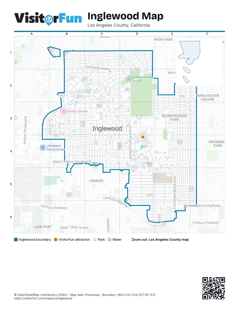
Street index of Inglewood
Each street on the sheet and the grid squares it crosses.
- San Diego FreewayB2, B3, B4, B5
- Vesta StreetB2
- West Century BoulevardB4, C4, D4, E4, F4
- Crenshaw BoulevardE2, E3, E4, E5, E6
- West Manchester BoulevardA3, B3, C3, D3, E3, F3
- East Florence AvenueC2, D2
- West Imperial HighwayD6, E6, F6
- West Florence AvenueB2, C2, D2, A3, B3
- South La Brea AvenueC3, C4
- South La Cienega BoulevardB1, B2, B3, B4
- North La Brea AvenueC1, C2, C3
- East Manchester BoulevardC3, D3
- South Ash AvenueB3, B4
- Hawthorne BoulevardC4, C5
- West Manchester AvenueF3
- South Van Ness AvenueF2, F3, F4, F5, F6
- Centinela AvenueB1, C1, C2, D2
- South Prairie AvenueD3, D4, D5, D6
- West BoulevardD1, D2, D3
- Aviation BoulevardA3, A4
- Crenshaw DriveE2, E3
- South La Tijera BoulevardB1
- Prairie AvenueD6
- West 104th StreetC5, D5, E5, F5
- South 5th AvenueE2, E3, E4, E5
- Arbor Vitae StreetA4, B4, C4, D4
- South 8th AvenueE2, E3, E4, E5
- West 108th StreetD5, E5, F5
- West 83rd StreetB3, D3, E3, F3
- East Hyde Park BoulevardD1, C2
- West Beach AvenueB1, B2, C2
- West 64th StreetB1, C1
- North Eucalyptus AvenueC1, C2, C3
- South Inglewood AvenueC3, C4
- South Grevillea AvenueC3, C4
- West Hillcrest BoulevardA3, B3, C3
- East Fairview BoulevardC1, D1
- South Eucalyptus AvenueC3, C4
- North Market StreetC1, C2, C3
- West Hyde Park BoulevardB2, C2, B3
- Pincay DriveD3, E3
- East Hillcrest BoulevardC3
- North Inglewood AvenueC1, C2, C3
- West Arbor Vitae StreetE4, F4
- North Prairie AvenueD2, D3
- North Hillcrest BoulevardC2, C3
- South Market StreetC3
- West Fairview BoulevardB1, C1
- West Regent StreetB3, C3
- East Regent StreetC3, D3
- East Kelso StreetC3, D3
- Edgewood StreetC1, C2
- Warren LaneC2, D2
- North Marlborough AvenueD1, D2
- West 76th StreetE2
- Lennox BoulevardD5
- West 89th StreetF3
- Maitland AvenueF2, E3
- North Locust StreetC2, C3
- East Hyde Park PlaceC1, D1
- 8th AvenueE3, E5
- Kareem CourtD3
- Field AvenueC1
- Park CircleE3
- South Locust StreetC3
- West 92nd StreetF4
- West Juniper StreetC2
- Fairview BoulevardB1
- Overhill DriveC1
- Hyde Park BoulevardD1
- West 67th StreetD1
- South Hillcrest BoulevardC3
- Alviso AvenueD1
- North Beach StreetB1
- 7th AvenueE2, E3, E4, E5
- South 2nd AvenueF2, F3, F4, F5
- South 3rd AvenueF2, F3, E4, F4, E5, F5
- West 111th StreetD5, E5, F5
- West 109th StreetD5, E5, F5
- South 4th AvenueE3, E4, E5
- West 102nd StreetC4, D4, E4, F4, E5
- South Yukon AvenueD4, D5, D6
- West 78th StreetD2, E2, F2
- West 112th StreetD5, E5, E6, F6
- South 10th AvenueE2, E3, E4, E5
- West 113th StreetD6, E6
- West 85th StreetD3, E3, F3
- West 82nd StreetE2, D3, E3, F3
- South Fir AvenueC3, C4
- West 88th StreetE3, F3
- West 110th StreetD5, E5
- South Doty AvenueD4, D5, D6
- West Hardy StreetC4, E4, F4
- West 111th PlaceD5, E5
- West 78th PlaceD2, E2, F2
- West 79th StreetD2, E2, F2
- South 6th AvenueE3, E4
- East Hardy StreetC4, D4
- East Brett StreetC1, D1
- West 84th StreetE3, F3
- West 80th StreetD2, E2, F2
- West 81st StreetD2, E2, F2
- South Flower StreetD3, D4
- East 67th StreetD1, C2, D2
- South Cedar AvenueB3, B4
- West 77th StreetE2, F2
- 11th AvenueE3, E4
- North Oak StreetB2, C2, B3
- West Queen StreetB3, C3
- South Victoria AvenueE2, E3
- Stadium DriveD3, D4
- West Olive StreetB3, C3
- South Lemoli AvenueE5, E6
- South Osage AvenueD3, D4
- West Buckthorn StreetB4, C4
- Myrtle AvenueC3, C4
- Walnut StreetC3, C4
- West 101st StreetC4, D4, E4, F4
- West 84th PlaceD3, E3, F3
- West Kelso StreetB3, C3
- District DriveD3, D4
- West Hillsdale StreetB1, C1
- West 64th PlaceB1, C1
- West 98th StreetB4, C4
- West 116th StreetD6, E6
- Stepney StreetC2, D2
- West Ellis AvenueB1, C1
- West Spruce AvenueB3, C3
- Hindry AvenueB3, B4
- South Glasgow AvenueB3
- West 90th StreetE3, F3
- East Nutwood StreetC3, D3
- East 65th StreetD1
- West 107th StreetD5, F5
- Hargrave StreetC1, D1
- Lime StreetB3, C3
- East Hazel StreetC2, D2
- Oak StreetB3, B4
- East Buckthorn StreetD3, C4, D4
- Isis AvenueB3, B4
- East Spruce AvenueC3, D3
- Carlton DriveD3
- Thoreau StreetE5, F5
- East Tamarack AvenueC3, D3, C4
- West 105th StreetD5
- West 106th StreetD5
- Venice WayB2, C2
- East Ellis AvenueC1
- North Park AvenueD1, D2
- Magnolia AvenueB3, C3
- West 118th PlaceD6, E6
- West Plymouth StreetB2, C2
- South Spinning AvenueF5, F6
- Rosewood AvenueC4
- Maple StreetC4
- Welton WayC1, D1, D2
- South Truro AvenueC4
- South Burin AvenueC4, C5
- East 99th StreetC4, D4
- East 97th StreetC4, D4
- Touchdown DriveD3, D4
- North Gay StreetD1
- North Acacia StreetB1, B2
- West 94th StreetB4, C4, F4
- Champions WayD4
- East La Brea DriveC3, D3
- West 117th StreetD6, E6
- East Hillsdale StreetC1, D1
- Briarwood LaneD3, E3
- West Elm AvenueB3, C3
- North Long StreetD1, D2
- West 82nd PlaceD3, E3
- East Queen StreetC3, D3
- West 99th StreetB4, C4, E4
- North Chester AvenueD1
- East Beach AvenueC2, D2
- Ardath AvenueE5, E6
- East Redondo BoulevardD1, D2
- Yukon AvenueD4
- South 1st AvenueF4, F5
- East 66th StreetD1
- Glenway DriveB2
- Cullivan StreetE5, F5
- 6th AvenueE4, E5
- Grace AvenueC2, D2
- South Simms AvenueE6
- West 118th StreetD6, E6
- Nectarine StreetB3, C3
- West 103rd StreetC5, D5
- West 95th StreetB4, C4
- Club DriveE4
- West 115th StreetD6, E6
- South Felton AvenueB4
- West 91st StreetF3
- Wexham WayD1
- Van Wick StreetE5, F5
- South Dehn AvenueE6
- East Plymouth StreetC2
- South Cherry AvenueE6
- Imperial HighwayE6, F6
- South Freeman AvenueC4, C5
- South Byrd AvenueE3, F3
- Larch StreetC4
- South Ocean Gate AvenueB4, B5
- Renaissance WayE3, E4
- Victor AvenueB2
- East 68th StreetD1, D2
- Wilkie AvenueE5
- Hudspeth StreetE6, F6
- Lake Park AvenueD4
- North Exton AvenueC2
- East 98th StreetC4
- Hill StreetB1, B2
- Hollypark DriveE3, E4
- Redfern AvenueB4
- Manchester TerraceC3, D3
- Atkinson AvenueE5
- Victory StreetD4
- Evergreen StreetB1, B2
- Orchard DriveC4
- South Oak StreetB3, B4
- 8th PlaceE5
- West 96th StreetB4, C4, F4
- South 12th AvenueE3
- South Chanera AvenueE5
- North Cedar AvenueB2, B3
- East Parking Garage - Intuit DomeD4
- 10th AvenueE2
- Players Rd.D4, D5
- West Ivy AvenueC2
- Varus DriveD3, D4
- La Colina DriveC2, D2
- Saint John PlaceC2, D2
- Christopher AvenueE6
- Lawrence StreetE4
- Buckler AvenueC1
- West Luther LaneD4, E4
- Lamos StreetC2
- Meadowbrook LaneB2, C2
- Woodworth AvenueE4, E5
- North Fir AvenueC2, C3
- West 97th StreetB4, C4
- Forest StreetC1
- Intuit Dome - Fire LaneD4
- Cory DriveB2
- Scribner LaneD3, E3
- Manchester DriveD3
- West 3rd AvenueF2
- East Ivy AvenueC2
- Aerick StreetD3
- Mobility Hub - Intuit DomeD4
- South Larch StreetC3, C4
- Darby AvenueE4, E5
- Kensley DriveD3, E3
- South Crenshaw BoulevardE6
- South Garth AvenueB1
- South Copperwood AvenueB1
- Condon AvenueC1, C4
- East 64th PlaceC1
- Holly StreetB4
- Kenwood StreetB4
- Regent CircleD2, D3
- England AvenueE4, E5
- Laraway AvenueB4
- North Cedar StreetB1, B2
- East 94th StreetC4
- Alpha StreetD1
- Cullen WayD3, D4
- Enterprise AvenueB1, B2
- Howland DriveD2, D3
- Penridge PlaceD3
- Laurelwood DriveB1
- West Medici LaneD4, E4
- Cromwell LaneE3
- West 117th PlaceE6
- South Noble WayE3, E4
- Middlesex LaneE3
- Myers PlaceB3
- South Firmona AvenueC4
- South Mansel AvenueC4
- Dalerose AvenueC4
- East Garage - Century BlvdD4
- Grosvenor StreetC2
- South Buford AvenueB4
- South Burl AvenueB4
- Short StreetB1
- Stepney PlaceD2
- Bromley LaneE3
- Penney AvenueE5
- Casimir AvenueE5, E6
- Railroad PlaceB2, C2
- West 95th AvenueE4
- North Eastwood AvenueD3
- West 94th AvenueE4
- West Amberwood DriveB1
- West 93rd StreetB4, C4
- Cable PlaceC2
- Fair PlaceC1
- VIP West Garage - Fire LaneD4
- Kincaid AvenueB2
Things to do on the Inglewood map
Places on the map
- 99 Cents Only Stores
- Best Western Airport Plaza Inn
- Blessed Family Covenant Church
- Blue Zone
- Costco
- Crenshaw Imperial Plaza
- Crenshaw Imperial Station Inglewood Post Office
- Crenshaw-Imperial Branch City of Inglewood Public Library
- Darby Park
- Dollar Tree
- Downtown Inglewood
- Edward Vincent Jr. Park
- El Super Mexican Supermarket
- Elev8 Hotel Los Angeles LAX
- H3 Inn & Suites - LAX Airport
- Hillcrest Station Inglewood Post Office
- Hollywood Inn Express LAX
- Hollywood Park
- Inglewood High School
- Inglewood Park Cemetery
- Intuit Dome
- La Tijera Elementary School
- Morningside Park Branch City of Inglewood Public Library
- Morningside Park Station Inglewood Post Office
- Motel 6 Los Angeles, CA - Los Angeles - LAX
- Randy’s Donuts
- Red Zone
- Rivers Lake
- Rogers Park
- Royal Century Hotel
- SoFi Stadium
- Target
- The Home Depot
- The Marketplace at Hollywood Park
- The Village at Century
- Vons
- Wagner Branch Station Los Angeles Post Office
- Walgreens
- Woodworth-Monroe Academy
- Yellow Zone
Next to Inglewood
- Chesterfield Square
- Gramercy Park
- Hyde Park
- Lair Port
- Lennox
- Manchester Square
- Van Ness
© OpenStreetMap contributors, Open Database License, openstreetmap.org/copyright · Map data: Protomaps · Boundary: Who's On First (CC-BY 4.0); Quattroshapes (CC BY 2.0)