

California map
Kerman map
About 17,497 people live here (Census Bureau, 2024 estimate). The sheet's index lists 138 streets; West Kearney Boulevard, South Madera Avenue and West Sunset Avenue cross the most grid squares. Also on it: Kerman City Hall, Kerman High School and Kerman Middle School.
Open the map (PDF, US Letter)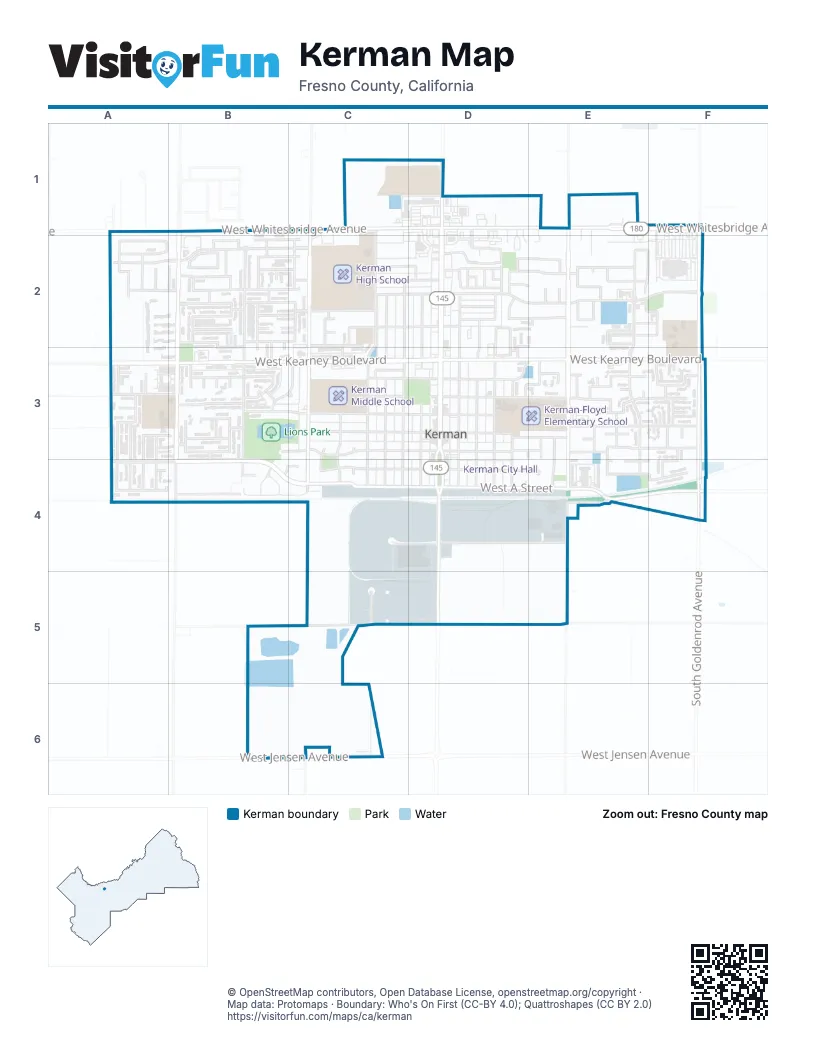
Street index of Kerman
Each street on the sheet and the grid squares it crosses.
- South 1st StreetC1, C2, C3, C4
- West Whitesbridge AvenueC1, D1, E1, F1
- North Madera AvenueD1
- South Kline StreetD1, D2
- South Madera AvenueD1, D2, D3, D4, D5
- North Goldenrod AvenueF1
- South Goldenrod AvenueF1, F2, F3, F4
- San Joaquin AvenueA2, B2, D2, E2
- South Joseph AvenueA2, B2, A3, A4
- South Kenneth AvenueA2, A3, A4
- South Michelle AvenueA2, A3
- South Susan AvenueA2, A3, A4
- West Botelho AvenueA2, B2, C2
- West Gateway BoulevardA2, B2, C2
- West Gentry AvenueA2
- West Middleton AvenueA2, B2, C2, D2
- West Sunset AvenueA2, B2, C2, D2, E2
- Middleton AvenueB2
- Monterey AvenueB2
- Park AvenueB2, B3
- Shepherd CourtB2, B3
- South Almond AvenueB2, B3
- South Chaffin AvenueB2, B3
- South Chafin AvenueB2
- South Gragnani AvenueB2, C2
- South Koleen AvenueB2
- South Lum AvenueB2
- South Siskiyou AvenueB2, B3, B4
- South Thomas AvenueB2, B3
- South Walnut AvenueB2
- Stanislaus AvenueB2
- Sunset AvenueB2, C2
- Walnut AvenueB2, B3, B4
- West David AvenueB2, C2
- West El Mar AvenueB2, C2, D2, E2
- West San Joaquin AvenueB2, C2, D2
- West Wooten CourtB2
- Wooten CourtB2, C2
- Carmel AvenueC2
- Carmel DriveC2
- Monroe DriveC2, C3
- South 2nd StreetC2, C3, C4
- South 3rd StreetC2, C3, C4
- South Boyd AvenueC2
- South del Norte AvenueC2, C3, C4, C5, C6
- South Manor DriveC2, C3, C4
- West El Mar LaneC2, D2
- West Monterey LaneC2
- West Stanislaus AvenueC2, D2, E2, F2
- 4th StreetD2
- Center StreetD2
- Circle DriveD2
- Circle Drive EastD2
- EpperlozaD2
- Golden WestD2
- Merlot AvenueD2
- Puesta del SolD2
- Sierra VistaD2
- South 4th StreetD2, D3, D4
- South 6th StreetD2, D3, D4
- South 7th StreetD2, D3, D4
- South 8th StreetD2, D3, D4
- South Merlot AvenueD2
- West Chardonnay AvenueD2, E2
- West Montery LaneD2, E2, D3
- Chablis AvenueE2
- Chardonnay AvenueE2
- El Mar AvenueE2
- El Mar CourtE2
- Olympic StreetE2
- South 10th StreetE2, E3
- South Bordeaux AvenueE2
- South Burgandy StreetE2, E3
- South Chablis AvenueE2
- South Olympic StreetE2
- South Vineland AvenueE2, E3, E4, E5
- Brian AvenueA3, B3
- E StreetA3, B3
- Lum AvenueA3, B3
- Michelle AvenueA3, A4
- Susan AvenueA3
- West Cyndi AvenueA3
- West Kearney BoulevardA3, B3, C3, D3, E3, F3
- West Matthew CourtA3, B3
- West Monterey AvenueA3, B3
- West Natalie AvenueA3
- West Troy AvenueA3
- Almond CourtB3
- B StreetB3
- Koleen CourtB3
- Lum DriveB3
- Meadow LaneB3
- Oak DriveB3
- Orchard AvenueB3
- South Boyd DriveB3, C3
- South Park AvenueB3, B4
- Walnut CourtB3
- West C StreetB3, C3, D3, E3, F3
- West D StreetB3, C3, D3, E3
- West E StreetB3, C3, D3, E3, F3
- West Oak DriveB3
- South Wooten Drive / West B StreetC3, C4, D4, E4
- West F StreetC3, D3, E3, F3
- West G StreetC3, D3, E3, F3
- South 9th StreetD3, D4
- South Pacheco DriveD3, E3
- Burgundy AvenueE3
- Celeste AvenueE3
- Gurdwara AvenueE3
- Karen AvenueE3
- McKenna CourtE3
- Palm CourtE3
- Palm StreetE3
- South 11th StreetE3
- South 12th StreetE3, E4
- South 16th StreetE3, E4
- South Karen AvenueE3
- South Sheri WayE3, E4
- West Chad CourtE3
- West Taylor AvenueE3
- South 17th StreetF3
- South 18th StreetF3, F4
- South 19th StreetF3
- South McKenna CourtF3
- West Taylor StreetF3
- Ashli AvenueA4
- West California AvenueA4, B4, C4, E4, F4
- West Dylan CourtA4
- West B StreetB4, C4, E4, F4
- South Industrial WayC4, C5
- West A StreetC4, D4, E4
- West Commerce WayD4
- May AvenueE4
- West Sheri CourtE4
- South McKenna AvenueF4
- West Sheri AvenueF4
- West Church AvenueC5, D5, E5
- West Jensen AvenueB6, C6
Places on the map
- Autumn Ridge
- CVS Pharmacy
- Kerckhoff Park
- Kerman Adult School
- Kerman City Hall
- Kerman High School
- Kerman Inn Motel
- Kerman Middle School
- Kerman Post Office
- Kerman U Save
- Kerman-Floyd Elementary School
- Kiwanis Park
- Lions Park
- McDonald's
- North Central FPD Station #21
- Nova High School
- Rite Aid
- Taco Bell
- Walmart
- Walmart Supercenter
- Wootten Park
© OpenStreetMap contributors, Open Database License, openstreetmap.org/copyright · Map data: Protomaps · Boundary: Who's On First (CC-BY 4.0); Quattroshapes (CC BY 2.0)















