

California map
Lawndale map
About 30,160 people live here (Census Bureau, 2024 estimate). The sheet's index lists 70 streets; Freeman Avenue, Condon Avenue and Firmona Avenue cross the most grid squares. Also on it: Da Vita HealthCare Partners, Baymont Lawndale/South Bay and Best Western.
Open the map (PDF, US Letter)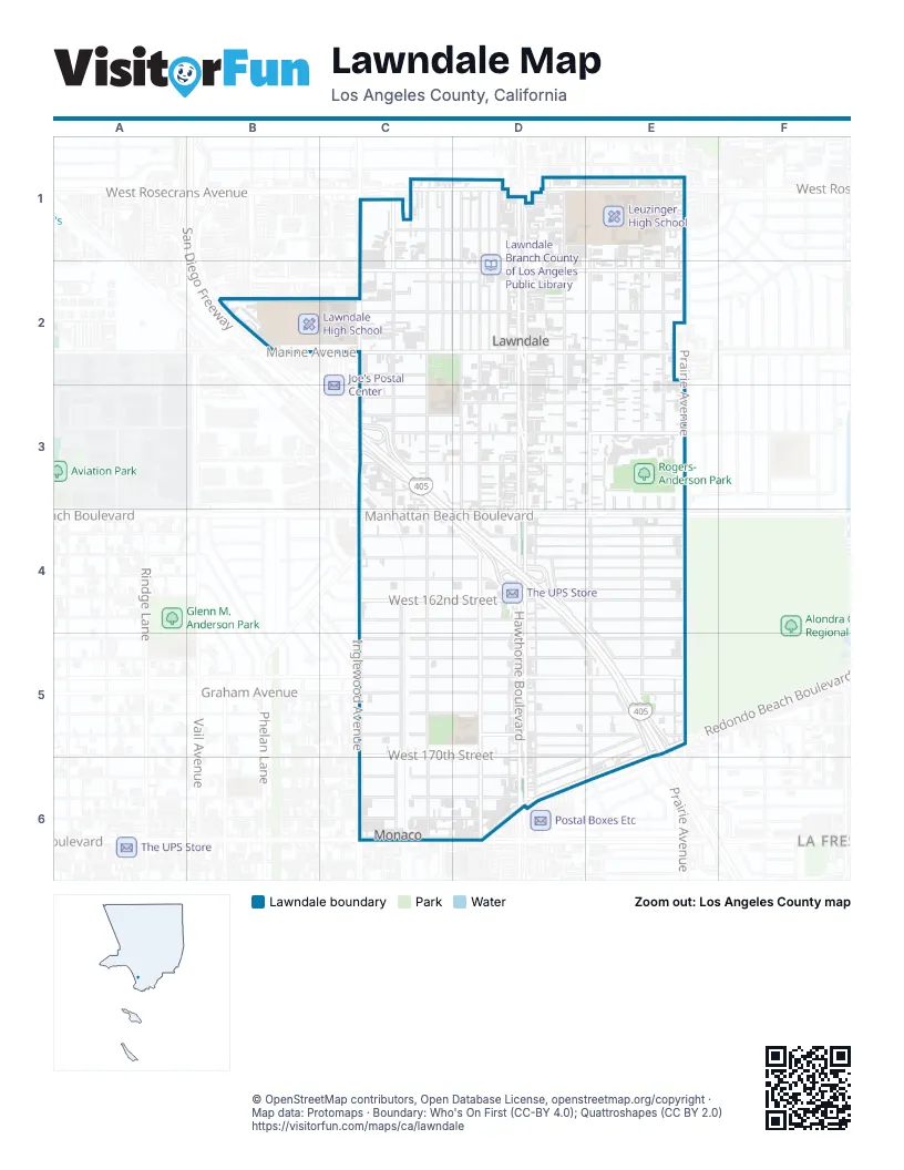
Street index of Lawndale
Each street on the sheet and the grid squares it crosses.
- Condon AvenueC1, C2, C3, C4, C5, C6
- Firmona AvenueC1, C2, C3, C4, C5, C6
- Inglewood AvenueC1, C2, C3, C4, C5, C6
- Kingsdale AvenueC1, C2, C6
- Ramona AvenueC1
- West 145th StreetC1, D1
- West Rosecrans AvenueC1, D1, E1
- Burin AvenueD1, D2
- De Oro LaneD1
- Grevillea AvenueD1, D2, D3, D4, D5, D6
- Hawthorne BoulevardD1, D2, D3, D4, D5, D6
- Larch AvenueD1, D2, D3, D4
- Mansel AvenueD1, D2, D3, D4
- Washington AvenueD1
- 145th StreetE1
- Avis AvenueE1, E2, E3, E4
- Eastwood AvenueE1, E2, E3, E4
- Freeman AvenueE1, E2, E3, D4, E4, D5, E5, E6
- Jefferson AvenueE1
- Osage AvenueE1, E2, E3, E4, E5, E6
- Prairie AvenueE1, E2, E3, E4, E5
- 148th StreetC2
- Marine AvenueC2, D2, E2
- West 147th StreetC2, D2, E2
- West 149th StreetC2, D2, E2
- West 152nd StreetC2
- 153rd PlaceC3, D3
- 153rd StreetC3, D3, E3
- 154th StreetC3, D3, E3
- 156th StreetC3, D3, E3
- San Diego FreewayC3, C4, D4, E5
- Wharff LaneC3
- Sombra AvenueD3, D4
- Rixford AvenueE3, E4
- Sayler AvenueE3, E4
- West 154th StreetE3
- Beland BoulevardC4
- Carlsbad StreetC4
- Faber StreetC4
- Manhattan Beach BoulevardC4, D4, E4
- Mc Bain StreetC4
- West 159th StreetC4, D4, E4
- West 160th StreetC4, D4
- West 161st StreetC4, D4
- West 162nd StreetC4, D4, E4
- West 163rd StreetC4, D4
- 160th StreetD4, E4
- 161st StreetD4, E4
- 163rd StreetD4, E4
- 159th StreetE4
- 164th StreetC5, D5, E5
- 165th StreetC5, D5, E5
- 166th StreetC5, E5
- 167th StreetC5, D5, E5
- 168th StreetC5, D5, E5
- 169th StreetC5, D5, E5
- Blaisdell AvenueC5
- Robinson StreetC5
- Voorhees AvenueC5
- West 166th StreetC5, D5, E5
- West 170th StreetC5, D5
- 170th StreetD5, E5
- 171st StreetD5, C6, D6
- Redondo Beach BoulevardE5, D6, E6
- 172nd StreetC6, D6
- 173rd StreetC6
- Artesia BoulevardC6, D6
- West 171st StreetC6, D6
- West 173rd StreetC6, D6
- Amie AvenueE6
Places on the map
- #1 Buffet Chinese Buffet Restaurant
- 7-Eleven
- 99 Cents Only Stores
- A Touch of Amour
- Ace Tailoring
- Al-Noor
- ampm
- Animal Hospital of South Bay
- Baymont Lawndale/South Bay
- Best Western
- Box Brothers
- Bright Now!
- Budget Inn
- Chevron
- CVS Pharmacy
- Da Vita HealthCare Partners
- El Super
- Floor Pros
- Get Crazy Deals
- Guitar Center
- Jane Addams Middle School
- Jane Addams Park
- Lawndale Branch County of Los Angeles Public Library
- Lawndale City Hall
- Lawndale High School
- Lawndale Post Office
- Leuzinger High School
- McDonald's
- Moda Italia
- Olympians Stadium
- Rogers-Anderson Park
- Smart & Final Extra!
- South Bay Place
- Spires Court
- Sprouts Farmers Market
- The UPS Store
- Travelers Inn
- William Green Elementary School
- William Green Park
Next to Lawndale
- La Fresa
© OpenStreetMap contributors, Open Database License, openstreetmap.org/copyright · Map data: Protomaps · Boundary: Who's On First (CC-BY 4.0); Quattroshapes (CC BY 2.0)















