

California map
Lompoc map
About 43,594 people live here (Census Bureau, 2024 estimate). The sheet's index lists 300 streets; North H Street, East College Avenue and West Central Avenue cross the most grid squares. Things to do inside the boundary: Skydive Santa Barbara.
Open the map (PDF, US Letter)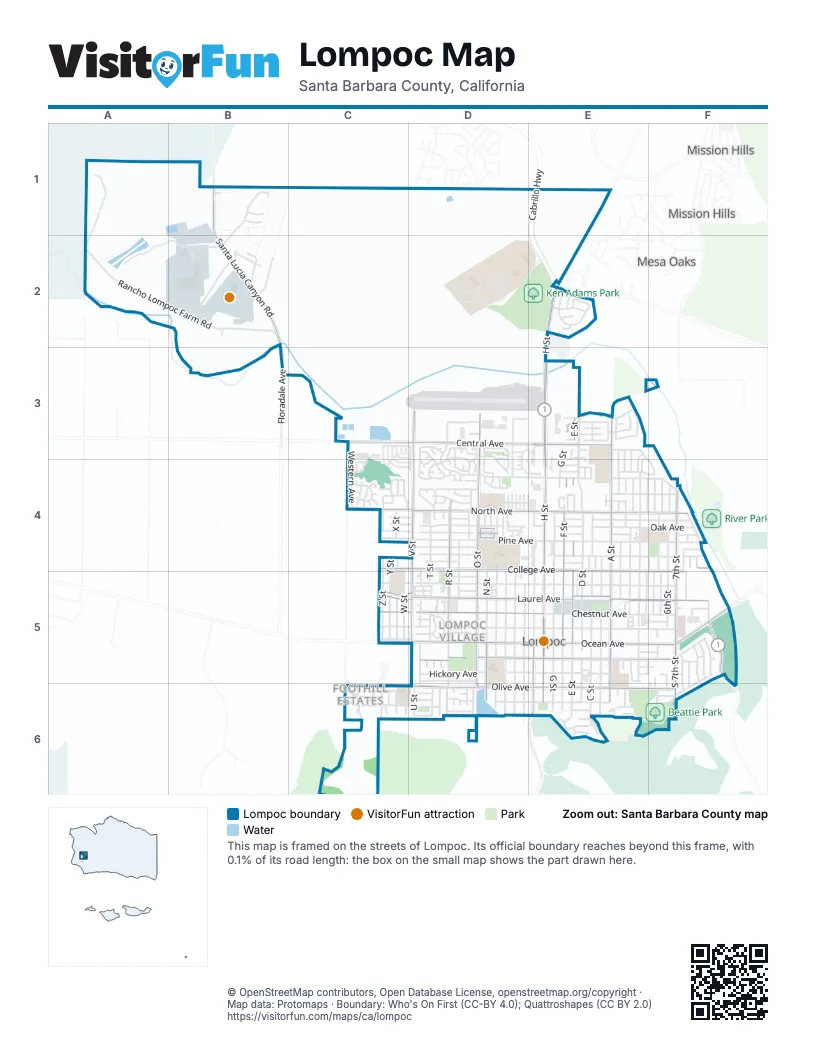
Street index of Lompoc
Each street on the sheet and the grid squares it crosses.
- Cabrillo HighwayE1, E2
- North H StreetE2, E3, E4, E5
- West Central AvenueC3, D3, E3
- East Ocean AvenueE5, F5
- West Ocean AvenueC5, D5, E5
- South H StreetE5, E6
- San Julian RoadF5
- Hwy 246F5
- East Central AvenueE3
- North O StreetD3, D4, D5
- North A StreetE3, E4, E5
- North V StreetD3, D4, D5
- East Laurel AvenueE5, F5
- West Laurel AvenueC5, D5, E5
- West North AvenueC4, D4, E4
- Santa Lucia Canyon RoadB1, B2
- West Olive AvenueC6, D6, E6
- West College AvenueC4, D4, E4
- West Chestnut AvenueC5, D5, E5
- 7th StreetF4, F5
- East College AvenueE4, F4, E5, F5
- F StreetE3, E4, E5
- North R StreetD4, D5
- East North AvenueE4, F4
- East Cypress AvenueE5, F5
- East Olive AvenueE6, F6
- North E StreetE3, E4, E5
- West Cypress AvenueD5, E5
- South I StreetE5, E6
- South N StreetD5, D6
- South A StreetE5, E6
- South 7th StreetF5, F6
- South O StreetD5, D6
- Floradale AvenueB2, B3
- Harris Grade RoadE2
- San Miguelito RoadE6
- D StreetE3, E4, E5
- Rancho Lompoc Farm RoadA2, B2
- 3rd StreetE3, E4, E5
- West Pine AvenueC4, D4, E4
- North L StreetD3, D4, D5
- East Pine AvenueE4, F4
- Perimeter RoadB2
- West Walnut AvenueC5, D5, E5
- West Maple AvenueC5, D5, E5
- East Airport AvenueE4, F4
- East Chestnut AvenueE5, F5
- East Maple AvenueE5, F5
- East Walnut AvenueE5, F5
- North G StreetE4, E5
- West Barton AvenueD3, D4, E4
- East Oak AvenueE4, F4
- Klein BoulevardB2
- Riverside DriveE3, F4
- North Z StreetC4, C5
- East Lemon AvenueE4, F4
- West Oak AvenueC4, D4, E4
- 2nd StreetE3, E4, E5
- 6th StreetF4, F5
- North M StreetD4, D5
- West Hickory AvenueD5, E5
- North W StreetC4, C5
- South C StreetE5, E6
- West Locust AvenueD6, E6
- West Cherry AvenueC4, D4
- East Locust AvenueE6, F6
- North N StreetD4, D5
- West Fir AvenueC6, D6
- East Hickory AvenueE5, F5
- West Airport AvenueC4, D4
- North X StreetC4, C5
- North Y StreetC5
- Orchid StreetE3, E4
- North K StreetD4, D5
- T StreetD4, D5
- South J StreetD5, D6
- South K StreetD5, D6
- South R StreetD5, D6
- South L StreetD5, D6
- South B StreetE5, E6
- South U StreetD5, D6
- North B StreetE4, E5
- South G StreetE5, E6
- South F StreetE5, E6
- Village Meadows DriveD3, D4
- South E StreetE5, E6
- George Miller DriveD3, E3
- Tangerine AvenueE4, F4
- Western AvenueC3, C4
- Brisa del MarE2
- North I StreetE4, E5
- North 1st StreetE4, E5
- North 8th StreetF4, F5
- West Nectarine AvenueD4
- Village Circle DriveD5
- Gardenia StreetE3, E4
- Oakridge RoadB1
- North J StreetD5
- East Cherry AvenueE4, F4
- North Q StreetD4, D5
- Crown CircleD5
- Marigold WayD4
- Bell AvenueE4, F4
- Lime AvenueD5
- Barton AvenueE4, F4
- North C StreetE4, E5
- Avalon StreetC6
- C StreetE4
- Bailey AvenueC3, C4
- Glen Ellen LaneD3, D4
- Oak Ridge RoadB1, B2
- Point Sal LoopC4
- P StreetD4
- University DriveE6
- East Barton AvenueE4
- West Apricot AvenueD5
- Briar Creek WayC3, C4
- Arnold AvenueD4
- South V StreetD5, D6
- Balboa CourtC6
- North 4th StreetF4, F5
- South D StreetE5, E6
- Beattie DriveF6
- North Daisy StreetF5
- North Lupine StreetE5
- North Poppy StreetF5
- Guard RoadB2
- North U StreetD4, D5
- Sheffield DriveF5, F6
- Bellflower LaneD3, D4
- CarrizoE2
- G StreetE3, E4
- Clemens WayE6
- Jason DriveD3, D4
- Somerset PlaceF5
- Princeton PlaceF5
- South M StreetD5, D6
- South 3rd StreetE5
- Alden AvenueD4
- Huntington PlaceF5
- Berkeley DriveF5
- Amherst PlaceF5, F6
- Stonebrook DriveD3, D4
- West Lemon AvenueC4, D4
- Jasmine StreetE4
- South Sage StreetD5, D6
- Lupine StreetF4
- Poppy StreetF4
- West Date AvenueD5
- Daisy StreetF4
- West Prune AvenueD4
- Aster LaneD3, D4
- Conception DriveC4
- South Z StreetC6
- West Ocean WayC5, D5
- West Loquat AvenueC6, D6
- Archer StreetD4
- Aviation DriveD3
- Quail CircleE5
- East Fir AvenueE6
- Summerwood LaneD4
- Palm DriveE4
- LaderaE2
- North T StreetD5
- North 5th StreetF4, F5
- Coleman DriveE3
- B CourtE3, E4
- Bush AvenueE3
- Birch AvenueE4
- South T StreetD6
- North 6th StreetF5
- Hancock DriveE2
- Armstrong StreetD4
- South O PlaceD6
- South 5th StreetF5, F6
- Colbert DriveE3
- Coronado DriveC6
- Cooper DriveE3
- Barrington PlaceF5, F6
- South P StreetD5, D6
- Crosby DriveE3
- Calle de la BonitaD4, E4
- Westbrook DriveD3, D4
- Cambridge DriveE6
- Green Ridge CircleC3
- Viola WayD3, D4
- 5th StreetF4, F5
- South X StreetC6
- Northbrook DriveD3
- Y StreetC4
- 1st PlaceE3, E4
- Cagney WayE3
- North 12th StreetF5
- Anthony WayD4
- Eastbrook DriveD3, D4
- Calvert AvenueE3
- Alexander AvenueC4
- South 2nd StreetE5
- Honda WayC4
- North RoadB2
- Canfield AvenueE3
- Almond AvenueE4
- Meridian WayC4
- East Guava AvenueF5
- Peach AvenueE5, F5
- East Prune AvenueE4
- North 9th StreetF4, F5
- West Apple AvenueD5
- North E PlaceE4
- East Nectarine AvenueF4
- South Hawthorne StreetE6
- C CourtE3
- Elm LaneB1
- West Willow AvenueD6
- Countrywood DriveE3
- Palmetto AvenueF6
- North AvenueD4
- Calle de la EntradaD4
- Calle de OroD4
- Calle de la LuzE4
- Calle de Las FloresD4
- Pine LaneB1
- Plum LaneD5
- NogalE2
- Industrial WayF5
- Calle de la SuenoD4
- Calle de la CapltanD4
- Edwards PlaceE4
- Linda Vista DriveE3, E4
- Calle de la VegaD4
- Canfield DriveE3
- X StreetC4
- Canfield LaneE3
- East Mango AvenueE5, F5
- Pembrook DriveF5
- City AlleyD5
- Florence StreetD5
- North S StreetD4, D5
- North Larkspur StreetE4
- Primrose CourtD4
- West Northpoint PlaceD4
- Lilac StreetE4
- South 4th StreetF5
- Adams WayD4
- I StreetE4
- South 6th StreetF5, F6
- South Y StreetC6
- Commerce CourtD3
- Civic Center PlazaE5
- EncantoE2
- MaravillaE2
- AlamoE2
- Brookside DriveD3, D4
- Seabreeze WayD4
- West Guava AvenueD5
- Audubon DriveC4
- Andrews AvenueC4
- South Q StreetD6
- Oxford DriveE6
- RinconcitoE2
- Valley View DriveF5, F6
- North E CourtE3
- Oak AvenueD4
- Hermosa CourtC6
- Oleander StreetD4
- South 1st PlaceE5
- North 10th StreetF4
- B StreetE4
- Parkside WayD4
- Tarragon CourtD4
- Cordoba AvenueD3
- Countrywood CourtE3, E4
- Rock Rose LaneD4
- Canfield CourtE3
- M StreetD4
- South Rose StreetD5
- Lavender WayD5
- Malibu WayC6
- East Willow AvenueE6
- Southbrook DriveD4
- Alcott AvenueC4
- South Y PlaceC6
- Jalama CourtC4
- Jodi DriveD3
- South W StreetC6
- Bluff DriveE5
- Sage CourtD4
- Channing LaneE3
- Santa Clara DriveE6
- Bush CourtE3
- Victory RoadB1
- South 1st StreetE6
- South Tulip StreetD5
- Camellia CourtD3
- Regent StreetF5
- Sky View DriveF5, F6
- West Loquat CourtD6
- West Lemon PlaceC4
- Camden DriveF5
- East Chestnut CourtF5
Things to do on the Lompoc map
Places on the map
- Albertsons
- Aldi
- Allan Hancock College
- Anderson Recreation Center
- Arthur Hapgood Elementary School
- Barkin Park
- Beattie Park
- Box Shop
- Brewer-Clifton Winery
- Carl's Jr.
- Central Pacific Coast Hmong Alliance Church
- Clarence Ruth Elementary School
- College Center
- Comfort Inn & Suites
- Comprehensive Care Center
- Days Inn
- Dick DeWees Community and Senior Center
- Dollar General Market
- Embassy Suites by Hilton Lompoc Central Coast
- Federal Correctional Institution, Lompoc
- Grocery Outlet
- Hilton Garden Inn Lompoc
- Holiday Inn Express
- J.M. Park
- Ken Adams Park
- La Canada Elementary School
- La Favorita Maket
- Leonora Fillmore Elementary School
- Lompoc Airport
- Lompoc City Hall
- Lompoc Health - North Third Center
- Lompoc High School
- Lompoc Jr. High
- Lompoc Post Office
- Lompoc Public Library
- Lompoc Valley Medical Center
- Perimeter Road
- Ryon Park
- The UPS Store
- United States Penitentiary, Lompoc
Next to Lompoc
- Mesa Oaks
- Mission Hills
© OpenStreetMap contributors, Open Database License, openstreetmap.org/copyright · Map data: Protomaps · Boundary: Who's On First (CC-BY 4.0); Quattroshapes (CC BY 2.0)















