

California map
Long Beach map
About 450,901 people live here (Census Bureau, 2024 estimate). The sheet's index lists 231 streets; Long Beach Boulevard, Orange Avenue and Long Beach Freeway cross the most grid squares. Things to do inside the boundary: Aquarium of the Pacific, Bembridge House and Maverick Helicopters Long Beach.
Open the map (PDF, US Letter)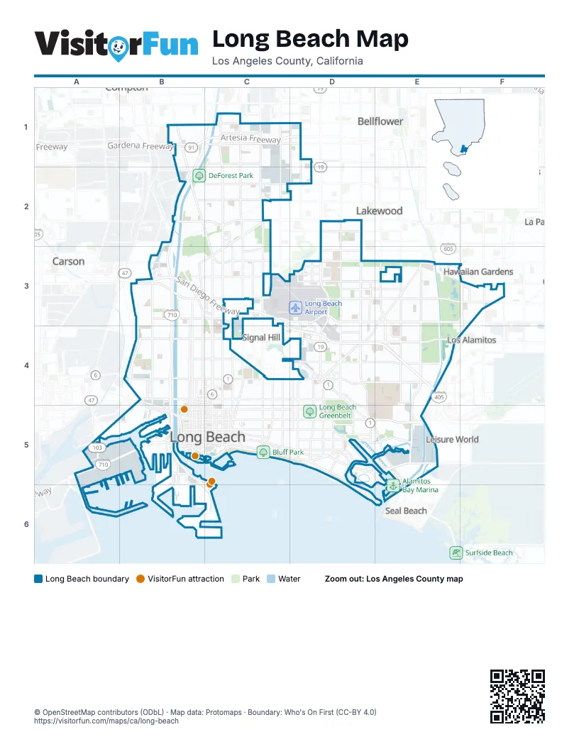
Street index of Long Beach
Each street on the sheet and the grid squares it crosses.
- Artesia FreewayB1, C1, D1
- East Artesia BoulevardB1, C1, D1
- East Greenleaf BoulevardB1
- Gardena FreewayB1
- Long Beach BoulevardB1, B2, C2, C3, C4, C5
- Long Beach FreewayB1, C1, B2, B3, B4
- South Susana RoadB1, B2
- West Artesia BoulevardB1
- Atlantic AvenueC1, C2, C3, C4, C5
- Cherry AvenueC1, C2, C3, C4, C5
- De Forest AvenueC1, B2
- East 68th StreetC1
- East 70th StreetC1
- East Harding StreetC1
- Harding StreetC1
- North Atlantic PlaceC1
- Orange AvenueC1, C2, C3, F3, C4, C5
- Paramount BoulevardC1, C2
- Artesia BoulevardD1
- Downey AvenueD1, D2
- Obispo AvenueD1, D2, D4, D5
- Del Amo BoulevardB2, C2, D2
- East Ana StreetB2
- East Market StreetB2, C2
- East South StreetB2, C2
- Victoria StreetB2
- West Market StreetB2
- California AvenueC2, C3, C4
- Candlewood StreetC2
- East 45th StreetC2
- East 45th WayC2
- East 46th StreetC2
- East San Antonio DriveC2, B3, C3
- North Paramount BoulevardC2
- Arbor RoadD2
- Bellflower BoulevardD2, D3, D4, D5
- Centralia StreetD2
- Clark AvenueD2, D3, D4
- Lakewood BoulevardD2, D3, D4
- Daisy AvenueB3, B4, B5
- East 223rd StreetB3
- East Bixby RoadB3, C3
- East Carson StreetB3
- East Wardlow RoadB3, C3, D3, E3, F3
- Hughes WayB3
- Magnolia AvenueB3, B4, B5
- North Pacific PlaceB3
- Pacific AvenueB3, B4, B5
- Pacific PlaceB3
- San Diego FreewayB3, C3, C4, D4, E4
- Santa Fe AvenueB3, B4
- South Santa Fe AvenueB3
- Via Oro AvenueB3
- Warnock WayB3
- West Bixby RoadB3
- West Carson StreetB3
- West San Antonio DriveB3
- West Spring StreetB3, C3
- West Wardlow RoadB3
- Airport WayC3, D4
- Carson StreetC3, D3, E3
- Cover StreetC3, D3
- East 31st StreetC3
- East Spring StreetC3, D3, E3, F3
- Junipero AvenueC3, C4, C5
- North Crest DriveC3
- Pine AvenueC3, C4, C5
- Tehachapi DriveC3
- Temple AvenueC3, C4, C5
- Walnut AvenueC3, C4
- Barbara London DriveD3
- Conant StreetD3, E3
- Donald Douglas DriveD3
- Douglas Center DriveD3
- East Conant StreetD3
- East Monlaco RoadD3
- Harvey WayD3
- Kilroy Airport WayD3, D4
- McGowen StreetD3
- Monlaco RoadD3, E3
- Redondo AvenueD3, D4, D5
- San Anseline AvenueD3
- Stineman AvenueD3
- Stineman CourtD3
- Worsham AvenueD3
- Los Coyotes DiagonalE3
- North Los Coyotes DiagonalE3, D4
- North Studebaker RoadE3, E4, E5
- Palo Verde AvenueE3, E4
- San Gabriel River FreewayE3, F3, E4, F4
- Snowden AvenueE3, E4
- Woodruff AvenueE3, E4
- Bloomfield AvenueF3
- Bloomfield StreetF3
- Claremore AvenueF3
- North Norwalk BoulevardF3
- Norwalk BoulevardF3
- Pioneer BoulevardF3
- Ritchie StreetF3
- 12th Street NorthB4
- Cedar AvenueB4, B5
- Chestnut AvenueB4, B5
- Cota AvenueB4
- East I StreetB4
- Loma Vista DriveB4, B5
- North Harbor AvenueB4, B5
- Pacific Coast HighwayB4, C4, D4, D5, E6
- Pier B StreetB4, B5
- San Gabriel AvenueB4
- Seabright AvenueB4
- Seaside FreewayB4, A5, B5
- Terminal Island FreewayB4, A5
- West 12th StreetB4, C4
- West 14th StreetB4, C4
- West 16th StreetB4, C4
- West 9th StreetB4, B5, C5
- West Anaheim StreetB4, C4
- West Hill StreetB4, C4
- West Willow StreetB4, C4
- Alamitos AvenueC4, C5
- East 12th StreetC4
- East 14th StreetC4
- East 16th StreetC4
- East 20th StreetC4, D4
- East Anaheim StreetC4, D4
- East Hill StreetC4
- East Pacific Coast HighwayC4, D4, D5, E5, E6
- East Willow StreetC4, D4, E4
- Elm AvenueC4, C5
- Locust AvenueC4, C5
- Martin Luther King Junior AvenueC4, C5
- East 28th StreetD4
- East Anaheim RoadD4, E4, D5
- East Atherton StreetD4, E4
- East Garford StreetD4
- East Los Coyotes DiagonalD4
- East Stearns StreetD4, E4
- Grand AvenueD4
- Hathaway AvenueD4
- Los Alamitos CircleD4
- North Bellflower BoulevardD4
- Outer Traffic CircleD4
- Park AvenueD4, D5
- Stearns StreetD4, E4
- Termino AvenueD4, D5
- Ximeno AvenueD4, D5
- Ximeno WayD4
- Barbanell StreetE4
- Anchorage RoadA5
- Henry Ford AvenueA5
- New Dock StreetA5
- North Henry Ford AvenueA5
- Pier A WayA5, B5
- Seaside AvenueA5
- West Seaside BoulevardA5
- Aquarium WayB5
- East 7th StreetB5, C5, D5, E5
- East 8th StreetB5, C5
- East Ocean BoulevardB5, C5, D5, D6, E6
- Golden AvenueB5
- Golden ShoreB5
- Harbor PlazaB5
- Harbor Scenic DriveB5
- Maine AvenueB5
- North Golden AvenueB5
- North Park CircleB5
- Pico AvenueB5
- Pier F AvenueB5, B6
- Pier G AvenueB5
- Queens HighwayB5, C5, B6, C6
- Queens Highway SouthB5
- Queens WayB5
- Queensway DriveB5
- Shoreline DriveB5, C5
- South Chestnut PlaceB5
- South Harbor Scenic DriveB5, C6
- South Pico AvenueB5
- South Pine AvenueB5, C5
- West 10th StreetB5, C5
- West 11th StreetB5
- West 3rd StreetB5, C5
- West 4th StreetB5, C5
- West 5th StreetB5, C5
- West 6th StreetB5, C5
- West 7th StreetB5
- West 8th StreetB5
- West BroadwayB5, C5
- West Chester PlaceB5
- West Ocean BoulevardB5
- West Seaside WayB5, C5
- 3rd StreetC5
- East 10th StreetC5, D5
- East 1st StreetC5
- East 2nd StreetC5, D5, E5
- East 3rd StreetC5, D5
- East 4th StreetC5, D5
- East 5th StreetC5
- East 6th StreetC5, D5
- East BroadwayC5, D5
- East Seaside WayC5
- Lime AvenueC5
- Linden AvenueC5
- Lindero AvenueC5
- Medio StreetC5
- North Locust AvenueC5
- Olive AvenueC5
- Paloma AvenueC5, D5
- The Promenade NorthC5
- Windsor WayC5, C6
- 54th PlaceD5
- Bay Shore AvenueD5
- Channel DriveD5, E5
- East Appian WayD5, E5
- East Colorado StreetD5
- East Marina DriveD5, E5
- East Naples PlazaD5, E5
- Eliot StreetD5
- Granada AvenueD5
- Livingston DriveD5
- Loynes DriveD5, E5
- Mira Mar AvenueD5
- Miramar AvenueD5
- Nieto AvenueD5
- North Ravenna DriveD5
- Santiago AvenueD5
- The ToledoD5
- College Park DriveE5
- Garden Grove FreewayE5
- North Marina DriveE5, E6
- Pier J AvenueC6
- Marina DriveE6
Things to do on the Long Beach map
Places on the map
- "R" Gym
- 1300 Gym
- 2nd & PCH
- 4th Street Postal
- 7-Eleven
- Admiral Kidd Park
- Aero Plex Aviation Center
- Alamitos Bay Beach
- Alamitos Generating Station
- Alamitos Neighborhood Library
- Albertsons
- All Souls Cemetery
- Aquarium of the Pacific
- Atlantic Medical Center
- Atlantic Plaza Park
- Ballast Point Brewing
- Bancroft Middle School
- Bank of America
- Bay Harbour
- Bay Towers at Bixby Knolls
- Belmont Shores Mobile Estates
- Best Western of Long Beach
- Bethany Church
- Beverly Plaza Apartments
- Bixby Hill
- Bixby Knolls Shopping Center
- Bixby Park
- Bixby Ranch Wetlands
- Bixby Riviera
- Bixby Terrace
- Bixby Village
- Bixby Village Golf Course
- Bixby Village Plaza
- Bluff Park
- Boeing
- Bret Harte Branch Long Beach Public Library
- Bryant Retained
- Bryant Station Post Office
Next to Long Beach
- Artesia
- Bellflower
- Carson
- Cerritos
- Hawaiian Gardens
- La Palma
- Lakewood
- Leisure World
- Los Alamitos
- Seal Beach
- Signal Hill
© OpenStreetMap contributors (ODbL) · Map data: Protomaps · Boundary: Who's On First (CC-BY 4.0)