

California map
Merced map
About 96,073 people live here (Census Bureau, 2024 estimate). The sheet's index lists 300 streets; G Street, Golden State Highway and M Street cross the most grid squares. Also on it: Fahrens Park, El Capitan High School and Golden Valley High School.
Open the map (PDF, US Letter)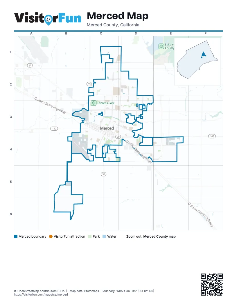
Street index of Merced
Each street on the sheet and the grid squares it crosses.
- Golden State HighwayB4, C5, D5, D6, E6
- West 16th StreetB4, C4, C5
- Martin Luther King Junior WayC4, C5
- V StreetB4, C4, B5
- West 14th StreetB4, C4, C5
- McSwain RoadB4
- West 13th StreetB4, C5
- Yosemite ParkwayD5, E5
- East 16th StreetC5, D5
- Snelling HighwayB4
- Los Banos HighwayC5, C6
- G StreetD1, D2, D3, C4, D4, C5, C6
- East Childs AvenueC5, D5, E5, F5
- West Olive AvenueB4, C4, D4
- Campus ParkwayE5, E6
- West Yosemite AvenueB3, C3, D3
- East Yosemite AvenueD3
- East Mission AvenueC6, E6, F6
- East Olive AvenueD4, E4
- West Childs AvenueB5, C5
- Ashby RoadA4, B4
- M StreetC1, C2, C3, C4, C5
- R StreetC2, C3, C4, B5, C5
- East Gerard AvenueC6, D6, E6, F6
- West Cardella RoadB2, C2, D2
- McKee RoadE3, E4
- South Parsons AvenueD5, D6, E6
- Parsons AvenueD3, D4
- West Main StreetB4, C4, C5
- El Redondo DriveB2, C2, B3
- West 15th StreetB4, C4, C5
- East Santa Fe AvenueC4, D4, D5
- South Coffee StreetE5, E6
- North Gardner AvenueD2, D3
- East Bellevue RoadC1, D1
- Barclay WayC1, C2
- Paulson RoadD2, D3
- Dunn RoadD2
- East South Bear Creek DriveD4
- Olivewood DriveC4
- Mercy AvenueD2
- San Augustine AvenueB2, B3
- East North Bear Creek DriveD4
- Kibby RoadF5
- Auto Center DriveB4
- West North Bear Creek DriveB4, C4, D4
- N StreetC4, C5
- Buena Vista DriveB3, C3
- Canal StreetC4, C5
- Q StreetC4, B5, C5
- Loughborough DriveB3, C3, B4
- S StreetB4, C4, B5
- West 11th StreetB4, B5, C5
- West 23rd StreetB4, C4
- K StreetC4, C5
- P StreetC4, B5, C5
- West 20th StreetB4, C4
- T StreetB4, C4, B5
- Wardrobe AvenueA5, B5
- West 25th StreetC4
- West 8th StreetB5, C5
- Tyler RoadD5, D6
- El Portal DriveD3, E3
- West 19th StreetB4, C4, C5
- O StreetC4, B5, C5
- East Alexander AvenueD4, E4
- West 22nd StreetB4, C4
- West 18th StreetB4, C4, C5
- West 12th StreetB4, B5, C5
- Brookdale DriveD3, E3
- West 21st StreetB4, C4
- East 27th StreetD4, E4
- East 22nd StreetC4, D4, D5
- U StreetB4, C4, B5
- Gove RoadA6
- East 23rd StreetC4, D4, D5
- East 21st StreetC4, D5
- Baker DriveD5, E5
- Freemark AvenueC1, C2
- West Donna DriveC3, D3
- West 9th StreetB5, C5
- South Thornton RoadA5, A6
- Merced AvenueD5, E5
- North Parsons AvenueD4, D5
- West 10th StreetB5, C5
- I StreetC4, C5
- H StreetC4, C5
- East 20th StreetC4, C5, D5
- Grogan AvenueA5, B5
- Cooper AvenueB4
- West 7th StreetB5, C5
- Bancroft DriveC1, C2
- West 24th StreetB4, C4
- Glen AvenueD4, D5
- East Donna DriveD3
- Dinkey Creek AvenueD5, E5
- North West AvenueB5
- Motel DriveD5
- Thornton RoadA5
- East 26th StreetC4, D4
- Horizons AvenueC2, C3
- Creekview DriveE3
- Columbia AvenueD3
- Lopes AvenueB5
- Lehigh DriveB2, C2
- San Jose AvenueC2, C3
- Pacific DriveB3, C3
- West 6th StreetB5, C5
- South M StreetC5, C6
- Arrow Wood DriveC2, D2
- East Cardella RoadD2
- West 26th StreetC4
- Brimmer RoadE5, E6
- Esplanade DriveB3, C3
- W StreetB4, B5
- Rambler RoadC4
- Bedford DriveD4
- Community College DriveC2, D2
- D StreetC5, D5
- Andover WayE5, E6
- Hawk DriveA5, B5, A6, B6
- East Main StreetC5, D5
- Hansen AvenueD4
- Park AvenueC4, D4
- West Dickenson Ferry RoadA6
- Cordova AvenueD3
- West Santa Fe AvenueC4
- Oleander AvenueD4
- Austin AvenueB3, B4
- West 4th StreetB5, C5
- West 27th StreetC4, D4
- Willowbrook DriveB4
- Tolman WayC1, C2
- Green StreetD4, D5
- E StreetC5
- Sydney LaneB4, B5
- Campus DriveC3, D3
- East 18th StreetC5, D5
- Sibley PlaceC2
- South R StreetB5, B6
- La Habra StreetC6
- Pettinotti RoadB2, C2
- South N StreetC5, B6
- South Canal StreetC5, C6
- North Tower RoadF5
- Tower RoadF5, F6
- Winder AvenueC6
- Branco AvenueD4
- Meadows AvenueC3, C4
- Jema WayC1, C2
- East 19th StreetC5, D5
- Devonwood DriveB4, C4
- Northwood DriveC4
- North Coffee StreetE5
- Carol AvenueD5
- Teak AvenueD3, E3
- Joerg AvenueD3
- Orchard LaneD4, D5
- Tahoe DriveD4
- Beckman WayC1, C2
- Bodie StreetE5
- Mandeville LaneC1, D1
- Calimyrna AvenueD4, D5
- East 13th StreetC5
- West 5th StreetB5, C5
- White Dove AvenueD2, D3
- B StreetC5, D5
- Mansionette DriveD2, D3
- West 28th StreetC4, D4
- Cherokee AvenueD3, D4
- Notre Dame AvenueC2, C3
- East 15th StreetC5, D5
- Andrea DriveC2
- Lasalle DriveC2
- Whitewater WayE3
- Wainwright AvenueD4
- Macready DriveB5
- Silverado AvenueD3, E3
- Cheyenne DriveB3
- West Gerard AvenueB6, C6
- Athena Dr.C1, C2
- Vernal AvenueD3
- Quail AvenueD2, D3
- Tenaya DriveD4
- West Alexander AvenueC4, D4
- Explorador DriveE3
- Partridge DriveD3
- Delong StreetD5
- Union AvenueD5
- Sonora AvenueD3
- South West AvenueB5, B6
- Conestoga DriveB3, C3
- Story AvenueD4
- West 2nd StreetB5
- East San Pedro StreetC6
- Saratoga AvenueD4
- Collins DriveC3, C4
- Sarasota AvenueB3
- Gabriel DriveE3
- Riggs AvenueB5
- Strathmore PlaceC2, D2
- Almond AvenueD5
- Capella DriveE6
- El Capitan AvenueD3, D4
- Heron WayA5
- Sacramento DriveB3
- Cone AvenueC5
- Hawthorne AvenueD4
- R Street NorthC2, C3
- Paseo Redondo DriveC3
- Paseo Verde AvenueC3
- Paseo Verde DriveC3
- Black Hawk AvenueD3
- Cypress Point DriveD3
- Seneca StreetD3, D4
- Saint Andrews DriveD3
- Saint Tropez AvenueC2, C3
- College Green DriveC4
- West 3rd StreetB5
- Cormorant DriveD2
- Shamrock AvenueD3
- Solstice AvenueC2, C3
- University DriveC3
- Ballantyne DriveE6
- Stephanie DriveC1
- Stonybrook AvenueB4
- Blue Water DriveE5
- Ironstone DriveC2
- Marie LaneD4
- Farmdale AvenueC6
- Nottingham AvenueD3, D4
- Brittany WayB6, C6
- Massasso StreetB4, B5
- Marybelle DriveC2
- Santiago AvenueB3
- Robin Hood LaneD3
- Kimberly AvenueD3, D4, E4
- Alviso DriveB2, B3
- Bianchi LaneB4
- Carmen WayC6
- Nottingham LaneD4
- Bixby WayC2
- Durant WayC1, D1
- 6th AvenueD4
- Linda LaneB4, B5
- Robinson DriveD4
- Alpine DriveD4
- Barney StreetD4, D5
- East 11th StreetC5
- Gettysburg AvenueD4, E4
- Stellars Jay LaneD1
- Irma DriveC1, C2
- Lexington AvenueD4
- Merill PlaceC2, D2
- Wathen AvenueC3
- North Massasso StreetB4
- F StreetC4, C5
- Jessie DriveC2
- Suzanne DriveC2
- Wooddale AvenueE3, E4
- Agnes WayD4
- Mather RoadC6
- Yuba River DriveE5
- Derby DriveB2, E6
- Manzanita AvenueD5
- South G StreetC5
- Pacheco DriveE3
- Dynes StreetB3
- Marthella AvenueD5
- Rose AvenueD5
- Shirley StreetD5
- Aviles DriveE3
- Freestone DriveE3
- Pluim DriveE5, E6
- Sandpiper AvenueD2, D3
- Buckner RoadE6
- Round Hill DriveC2
- Barroso AvenueC6
- Denver AvenueC3
- Catalina DriveB3, C3
- Seminole DriveD3
- Carmel RoadE5, E6
- Mallard DriveD3
- Denver WayB3, C3
- Citadel AvenueE5
- Kernland AvenueD3, D4
- Mono Lake AvenueE5
- Ostrander AvenueE5
- Hutchinson LaneD1, C2, D2
- Villa DriveD4
- Destiny DriveD2
- River Rock RoadE3
- Hart DriveC2
- San Moritz AvenueB3
- Wildcat DriveB2, C2
- Aspen StreetD4
- Favier DriveD2, D3
- Emerald DriveD4
- Redwing DriveD3
- Fairfield DriveC3
Places on the map
- Ada Givens Park
- Applegate Park
- Bear Creek Park
- Beer Creek Village
- Black Rascal Strip Park
- Charles Ogletree Park
- Civic Ballpark
- Costco
- Court House Square Park
- Don Stowell Elementary
- East Merced High School
- El Capitan High School
- El Portal Plaza
- Fahrens Park
- Farmdale Elementary
- Gateway Marketplace
- Golden Valley Health Center
- Golden Valley High School
- Hoover Middle School
- Joe Herb Park
- John Fremont Elementary School
- John Muir Elementary School
- Malibu Boats
- Marketplace at Merced
- McNamara Park
- Merced Cemetery
- Merced County Fairgrounds
- Merced County Law Library
- Merced Head Start
- Merced Marketplace
- Merced Post Office
- Merced Regional Airport/Macready Field
- Merced Regional Sports Complex
- Mercy Medical Center Merced
- North Merced Union High School
- Our Lady of Mercy School
- Pioneer Elementary School
- Playa Merced
- Postal Connections
- Rahilly Park
© OpenStreetMap contributors, Open Database License, openstreetmap.org/copyright · Map data: Protomaps · Boundary: Who's On First (CC-BY 4.0); Quattroshapes (CC BY 2.0)















