

California map
Modesto map
About 220,592 people live here (Census Bureau, 2024 estimate). The sheet's index lists 55 streets; Golden State Highway, Pelandale Avenue and Sisk Road cross the most grid squares. Also on it: Briggsmore Plaza, Copper Creek and Coralwood.
Open the map (PDF, US Letter)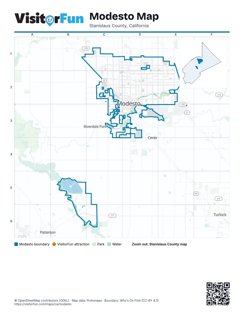
Street index of Modesto
Each street on the sheet and the grid squares it crosses.
- Golden State HighwayB1, C1, C2, D3
- Pelandale AvenueB1, C1, D1
- Sisk RoadB1, C1, C2
- Beckwith RoadC1
- Dale RoadC1
- Prescott RoadC1, C2
- Standiford AvenueC1, D1
- Tully RoadC1, C2
- Claratina AvenueD1
- Coffee RoadD1, D2
- McHenry AvenueD1, D2
- Oakdale RoadD1, D2
- Sylvan AvenueD1, E1
- Claus RoadE1, E2, E3
- Roselle AvenueE1, E2
- 9th StreetC2, D2, D3
- Blue Gum AvenueC2
- Kansas AvenueC2
- Kansas Avenue ExtensionC2
- Needham OverpassC2, D2
- North 9th StreetC2
- North Carpenter RoadC2
- West Briggsmore AvenueC2, D2
- 15th StreetD2
- 17th StreetD2
- 19th StreetD2
- 6th StreetD2, D3
- Burney StreetD2
- Downey AvenueD2
- East Briggsmore AvenueD2, E2
- El Vista AvenueD2, D3
- G StreetD2, D3
- H StreetD2, D3
- K StreetD2
- L StreetD2, C3, D3
- La Loma AvenueD2, D3
- Needham StreetD2
- Scenic DriveD2, E2
- Maze BoulevardC3, D3
- Paradise AvenueC3, D3
- Paradise RoadC3
- South Carpenter RoadC3
- Tuolumne BoulevardC3, D3
- West Hatch RoadC3, D3
- 1st StreetD3
- 5th StreetD3
- B StreetD3
- Crows Landing RoadD3
- D StreetD3
- Mitchell RoadD3, E3
- South 9th StreetD3
- Yosemite BoulevardD3, E3
- East Whitmore AvenueD4
- West Whitmore AvenueD4
- West Main AvenueB6, C6
Places on the map
- Briggsmore Plaza
- Copper Creek
- Coralwood
- Doctors Medical Center - Behavioral Health Department
- Dry Creek
- Dry Creek Mobile Estates
- Dryden Park Golf Course
- East La Loma Park
- Encompass Health Rehabilitation Hospital Of Modesto
- Fleur de Ville
- James C. Enochs High School
- Legion Park
- Memorial Medical Center
- Modesto
- Modesto Creekside Golf Course
- Modesto Irrigation District Lateral Number 4
- Modesto Municipal Golf Course
- Naraghi Lake
- Oakridge Townhouse
- Peter Johansen High School
- Sundance Lake
- The Crossings
- The Grove
- Tuolumne River Regional Park
- Vintage Faire Mall
- Westgate Village
Next to Modesto
- Ceres
- Patterson
- Riverdale Park
- Turlock
© OpenStreetMap contributors (ODbL) · Map data: Protomaps · Boundary: Who's On First (CC-BY 4.0)