

California map
Oceanside map
About 170,941 people live here (Census Bureau, 2024 estimate). The sheet's index lists 300 streets; Mission Avenue, San Luis Rey Mission Expressway and Oceanside Boulevard cross the most grid squares. Things to do inside the boundary: Broken Yolk Cafe and Oceanside Adventures.
Open the map (PDF, US Letter)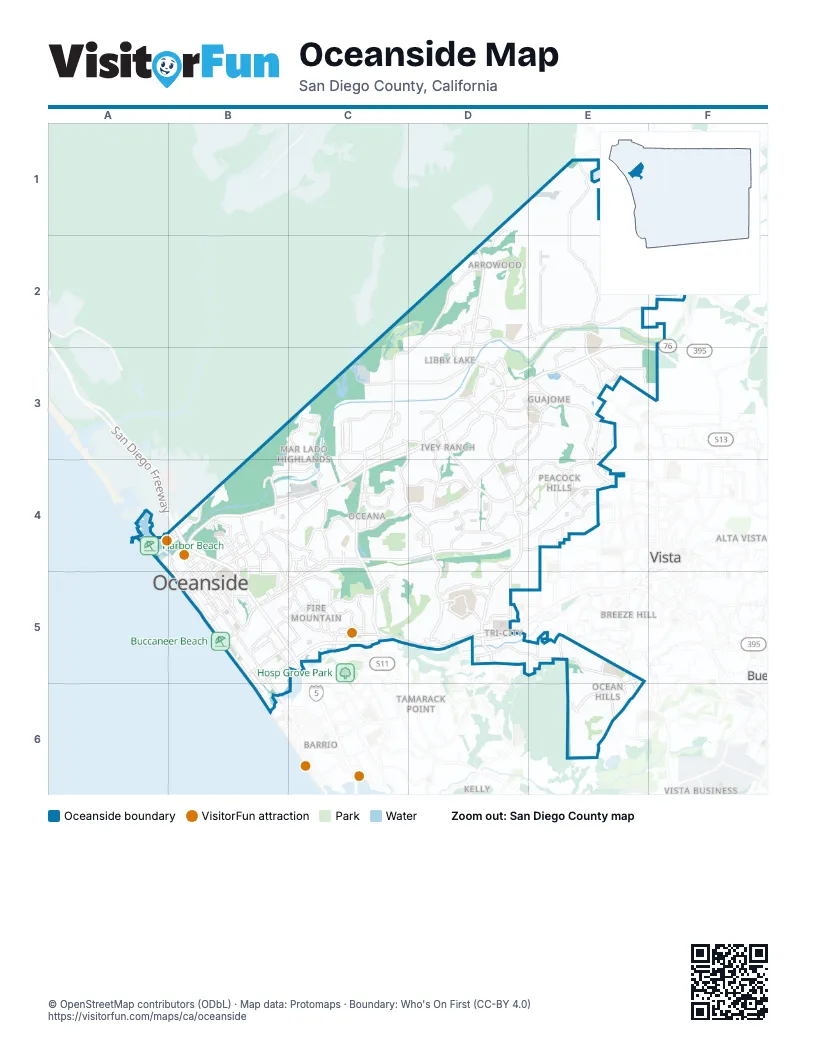
Street index of Oceanside
Each street on the sheet and the grid squares it crosses.
- Ronald Packard ParkwayC5, D5
- San Diego FreewayB4, B5, C5
- Vista WayB5, C5, D5, B6
- Capistrano DriveB4
- San Luis Rey Mission ExpresswayC3, D3, E3, B4, C4
- Mission AvenueE2, F2, C3, D3, E3, F3, B4, C4, B5
- College BoulevardD3, D4, D5
- Oceanside BoulevardC4, D4, E4, B5, C5
- North River RoadD2, E2, F2, C3, D3
- South El Camino RealC4, C5
- Douglas DriveD2, C3, D3, C4
- Melrose DriveE2, E3, E4
- Vandegrift BoulevardD2
- North Santa Fe AvenueE3
- Pacific Coast HighwayB4, B5, B6
- Stewart StreetB5, C5
- North El Camino RealC3, C4
- South Melrose DriveE5, E6
- North Coast HighwayB4
- Seagaze DriveB4, B5
- North Clementine StreetB4, B5
- Santa BellaD3
- North Melrose DriveE4
- San Luis Rey ExpresswayB4
- South Coast HighwayB5, B6
- El Camino RealC5
- Mesa DriveD3, E3, B4, C4, D4
- Old Grove RoadD3, D4, E4
- Rancho del Oro DriveC3, D3, C4, D4, D5
- Frazee RoadD3, E3
- Sleeping Indian RoadE1, E2
- Cannon RoadE5, E6
- Lake BoulevardD5, E5, E6
- South Pacific StreetB5, B6
- Canyon DriveB4, B5, C5
- Rancho del Oro RoadD5
- California StreetB5, C5
- Fire Mountain DriveC5
- Ivy RoadC5
- Foussat RoadC4
- North AvenueE4
- Cassidy StreetB5, C5
- Crouch StreetB4, C4, B5, C5
- Downs StreetC5
- Olive AvenueD4, E4
- Emerald DriveE4, E5
- Benet RoadB4
- Avocado RoadC5
- North Pacific StreetA4, B4, B5
- Plaza DriveD5
- North Foussat RoadC3, C4
- Grandview StreetB5, C5
- Surfrider WayB4, B5
- Hunsaker StreetB5, C5
- Bush StreetB4
- River RoadB4, C4
- South Harbor DriveA4
- Wisconsin AvenueB5
- Jefferson StreetC5
- North Cleveland StreetB4, B5
- Civic Center DriveB4, B5
- San Diego StreetB4
- West Vista WayD5
- Sunset DriveB4, E5
- Grant StreetB5
- Country Club LaneB4, B5
- Division StreetB5
- North Brooks StreetB4, B5
- North Emerald DriveE5
- Grapevine RoadE4
- Harbor DriveA4
- Avenida de la PlataD3, E3, D4, E4
- Wilshire RoadE1, E2
- Leisure Village WayE6
- Via Rancho RoadC4, D4
- Peacock BoulevardE4
- Pala RoadC3, D3
- South Tremont StreetB5, B6
- South Ditmar StreetB5
- Darwin DriveE3, E4
- Vista Campana SouthC4
- Thunder DriveD4, D5
- Ocean Ranch BoulevardD4
- Guajome Lake RoadE3
- Rivertree DriveC3, C4
- Shadow Tree DriveC3, C4
- Barnard DriveD5
- Temple Heights DriveE4
- South Clementine StreetB5
- Sagewood DriveE3
- Papagallo DriveD1, D2
- Industry StreetC4, C5
- Los Arbolitos BoulevardC3
- South Horne StreetB5
- Cameo DriveD5
- Laurel RoadC5
- Marblehead Bay DriveD2, D3
- Avenida del OroD4
- Silver Bluff DriveD3, E3
- Spur AvenueE3
- North Harbor DriveA4
- Old Ranch RoadE3
- Mission Gate DriveD3, D4
- Missouri AvenueB5
- Fredricks AvenueC3
- Marvin StreetD5, E5
- Morse StreetB5
- West Airport RoadB4
- Alvarado StreetB5, B6
- Mission Meadow DriveE3
- Palmer DriveC5
- Broadway StreetB5, B6
- Roselle StreetD5
- Sky Haven LaneE5
- Loretta StreetB4
- Skylark DriveC5
- Waring RoadD5
- Marron RoadD5
- Airport RoadB4, C4
- Alamosa Park DriveD3, E3
- Maxson StreetB4
- Dunstan StreetC5
- Nagata WayE2
- Belmont Park RoadE3, F3
- Via EsmarcaC5
- Hoover StreetC4, C5
- Greenbrier DriveB5
- Avenida EmpressaD4
- Buena Hills DriveD5
- South Oceanside BoulevardB5, C5
- Vista BellaC4
- Holly StreetB4
- Neptune WayB4, B5
- North Ditmar StreetB4, B5
- Skyline DriveC5
- Glenhaven DriveE4
- Gold DriveD2
- Fireside StreetC3, C4
- Soto StreetB5, C5
- Vista Campana NorthC4
- Cranberry StreetE2, E3
- North Tremont StreetB4, B5
- Shadowridge DriveE6
- Gardenia StreetD3
- Mac Donald StreetC4
- East Parker StreetD2
- Elaine AvenueD2
- Jonathon StreetD5, E5
- Roja DriveD2, D3
- Garrison StreetC4
- Ivey Ranch RoadD4
- Glaser DriveD5
- Wendela StreetE3
- Adams StreetD3
- San Luis Rey AvenueC3
- South Barnwell StreetC4
- North Horne StreetB4, B5
- Robinwood DriveE3
- Ridgeway StreetC5
- Camelot DriveC4
- Langford StreetB4
- Luiseno AvenueD3
- San Luis Rey DriveB4
- Claire DriveD2
- Peyri DriveC3
- Senior Center DriveD4
- Stephanie PlaceD2
- Pier View WayB4, B5
- Rio Plata DriveE3
- Eagles CrossingB4
- Sarbonne DriveC5
- Cardiff Bay DriveD2
- Sonja CourtC5
- Lemon StreetB4
- Tyler StreetD3
- Michigan AvenueB5
- Town Center DriveD3
- North Carey RoadB4
- Pear Tree LaneC4
- Roja StreetD2
- McKinley StreetD3
- Costa Vista WayC5
- Barry StreetD2
- Vine StreetB5
- Palermo DriveD3
- Seagate WayD4
- North Myers StreetB5
- Leisure Village DriveE6
- Academy RoadD3
- Apple StreetB5
- West Redondo DriveD2, D3
- North Redondo DriveD2
- Haymar DriveC5, D5
- Macario DriveD2
- Grace StreetB4, B5
- Foster StreetB4
- Carey RoadB4
- Monterey DriveB4
- Center AvenueB5
- Vista OceanaC4
- Monroe StreetD3
- Autumn DriveE4
- Crestwood DriveC4
- East Minnesota AvenueB5
- Alameda DriveE5, E6
- Corona DriveD3
- Monica CircleD2
- Laurel StreetB4
- Barnes StreetB4
- Oleander DriveD3
- Springtime DriveE4
- San Rafael DriveB4
- Windsor RoadE5
- Mystra WayE6
- Redondo DriveD3
- Gabrielieno AvenueD3
- Via ManosD3, E3
- El Monte DriveB4
- Henie Hills DriveC5
- Rancho Aqua HedoniaD5
- Hero DriveD4
- State Tree DriveB5
- Archer StreetB4
- Carmelo DriveB4
- El Corazon DriveD4
- Via CupenoD3
- Poplar RoadB4
- Sports Park WayE4
- Winter RoadE4
- Piazzo D Oro WayD5
- Elsinore StreetE3
- Goat Hill DriveB5
- Vista ReyC4
- Fall PlaceE4
- Oceanside Pier WayB5
- Montrose WayD3
- West Oceanside Harbor DriveA4
- Commerce StreetB5
- Macdonald StreetC4
- Westwood RoadD5
- Town CenterD3
- Ravine RoadE4
- Village DriveD2
- South Myers StreetB5, B6
- South Nevada StreetB5
- South Freeman StreetB5, B6
- Bella Collina StreetD3, E3, D4, E4
- Avenida DescansoC3, D3
- Kelly StreetB5, C5
- Bellingham DriveD2
- Arthur AvenueD2
- Catalina CircleE4
- Precious Hills RoadE2, F2
- Whaley StreetB5, C5
- Evergreen ParkwayB5
- Benet Hill RoadB4
- Havenwood DriveE4
- Thomas StreetD5, E5
- Valley RoadC5
- Cinnamon WayC4, D4
- Avenida del GadoD3
- Gallery DriveD3
- South Cleveland StreetB5
- Circulo del LagosC3
- Grove View RoadE2
- Breakaway DriveD2
- Jeffries Ranch RoadE3
- Toopal DriveB4, C4
- Lewis StreetD5, E5
- Luna DriveD2, D3
- Pacific TerraceB5, B6
- Vista Pointe BoulevardD2
- Leon StreetD2
- Carriage CircleC5, D5
- Palmera DriveE3
- Holiday WayD2, D3
- South Tait StreetB5
- Ord WayE4
- Kurtz StreetB5, C5
- Masters DriveD3
- Las Vegas DriveC4
- Masterpiece DriveD3
- Mira Pacific DriveD5
- Morro Heights RoadE1
- Calle MontecitoD3
- Oceanview RoadC5
- Calle Buena VenturaD5
- Mainsail RoadC4
- Panorama Ridge RoadE3, E4
- Nighthawk WayE5, E6
- Willowbrook DriveE3
- Chasin StreetD4, E4, D5
- Cottingham StreetC4
- Broken Hitch RoadE3, E4
- La Paloma LaneE1, E2
- Avenida de LoyolaC5, D5
- Galicia WayE6
- Lexington CircleD4
- Sunningdale DriveC3
- Via Puerta del SolF2
Things to do on the Oceanside map
Places on the map
- Alamosa Park Elementary School
- Arrowood Golf Course
- Buccaneer Beach
- Buccaneer Beach Park
- Buddy Todd Park
- Capistrano Park
- Cesar Chavez Middle School
- College Boulevard
- Crown Heights
- Del Rio Elementary School
- Ditmar Elementary School
- E G Garrison Elementary School
- El Camino Country Club
- El Camino High School
- El Camino North Center
- Emerald Isle Golf Course
- Empresa Elementary School
- Eternal Hills Memorial Park
- Fire Mountain
- Goat Hill Park Golf Course
- Guajome Regional Park
- Harbor Beach
- Mance Buchanon Park
- Manheim San Diego Auto Auction
- Mission Marketplace
- Mission Vista High School
- Ocean Hills Country Club
- Oceanside High School
- Oceanside Municipal Golf Course
- Old Grove Marketplace
- Pacifc Coast Plaza
- Prince of Peace Abbey Benedictine Monastery
- Quarry Creek Shopping Center
- Saint Malo Beach
- Seaside
- SoCal Sports Complex
- South Oceanside Beach
- Town Center North
- Tri-City Medical Center
- Whelan Lake
Next to Oceanside
- Alta Vista
- Barrio
- Bonsall
- Breeze Hill
- Calavera Hills
- Carlsbad Village
- Hedionda Point
- Pala Vista
- Rancho Carlsbad
- Shadowridge
- Tamarack Point
- Vista map
© OpenStreetMap contributors, Open Database License, openstreetmap.org/copyright · Map data: Protomaps · Boundary: Who's On First (CC-BY 4.0); Quattroshapes (CC BY 2.0)















