

California map
Ridgecrest map
About 28,373 people live here (Census Bureau, 2024 estimate). The sheet's index lists 300 streets; South China Lake Boulevard, East Ridgecrest Boulevard and North Knox Road cross the most grid squares. Also on it: China Lake Golf Course, Desert Empire Fairgrounds and Leroy Jackson Park.
Open the map (PDF, US Letter)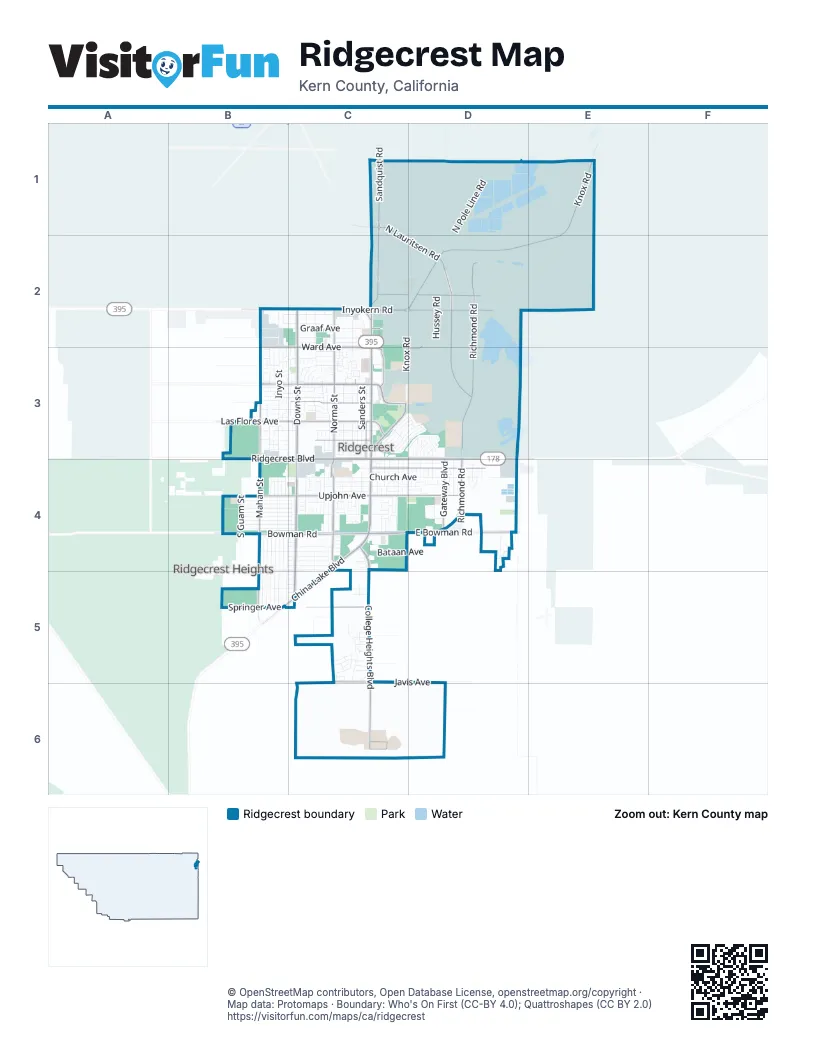
Street index of Ridgecrest
Each street on the sheet and the grid squares it crosses.
- South China Lake BoulevardC3, C4, B5, C5
- North China Lake BoulevardC2, C3
- East Ridgecrest BoulevardC3, D3, C4, D4
- West Ridgecrest BoulevardB3, C3, C4
- West Inyokern RoadB2, C2
- North Downs StreetC2, C3
- South Downs StreetC3, C4, C5
- West Drummond AvenueB3, C3
- North Norma StreetC2, C3
- West Las Flores AvenueB3, C3
- Bowman RoadB4, C4
- West Upjohn AvenueB4, C4
- Drummond AvenueB3, C3
- Las Flores AvenueC3
- North Knox RoadE1, C2, D2, E2
- College Heights BoulevardC4, C5, C6
- North Lauritsen RoadC1, D2, D3
- Sandquist RoadC1, C2
- East Bowman RoadC4, D4
- East Inyokern RoadC2, D2
- South Norma StreetC3, C4, C5
- North Richmond RoadD2, D3
- West Springer AvenueB5, C5
- East French AvenueC3
- East California AvenueC4, D4
- North Mahan StreetB2, B3
- South Mahan StreetB3, B4, B5
- Blandy AvenueC2, D2
- East Drummond AvenueC3
- East Upjohn AvenueC4, D4
- West Felspar AvenueC3
- Richmond RoadD3, D4
- South Gateway BoulevardD4, D6
- West Ward AvenueB2, C2, C3
- West Argus AvenueC3
- East Javis AvenueC5, D5, C6
- South Richmond RoadD4
- Ward AvenueC2
- Chelsea StreetC3
- East Ward AvenueC2, D2, C3, D3
- Balsam StreetC3
- West Javis AvenueC5
- Gateway BoulevardD4
- West French AvenueC3
- McLean StreetC2, C3
- East Las Flores AvenueC3
- Triangle DriveC2
- East Graaf AvenueC2
- Dolphin AvenueB4, C4, C5
- East Church AvenueC4, D4
- North Inyo StreetB2, B3
- South Sunland StreetC3, D3, C4, D4
- West Church AvenueB4, C4
- West Graaf AvenueB2, C2
- North Pole Line RoadD1, D2
- Nimitz AvenueC2, D2
- North Gold Canyon StreetC3, D3
- South Knox RoadC2, D2, C3
- West Reeves AvenueB2, C2
- H StreetD1, C2, D2
- West Coso AvenueB3, C3
- North Sierra View StreetC2, C3
- North Peg StreetC3
- West Saint George AvenueB4, C4
- Hussey RoadD2, D3
- West Bataan AvenueB4, C4
- South Sunset StreetC3, C4
- North Sanders StreetC3
- Bowen AvenueC2, D2
- Forrestal StreetC2, D2
- Independence StreetD2, D3
- Sims StreetB4, B5
- South Farragut StreetB4, B5
- South McCall StreetB4, B5
- Mayo StreetB4, B5
- Porter StreetB4, B5
- South Yorktown StreetB4, B5
- Burroughs AvenueC3, D3
- Monterey AvenueC3, D3
- South Ranger StreetB4, B5, C5
- West Rader AvenueC4
- Pilot Plant RoadD3
- West Perdew AvenueC2
- North Heritage DriveC3
- West Wilson AvenueB4, C4
- West Benson AvenueB4, C4
- West Mariposa AvenueB4, C4
- South Inyo StreetB4
- West Howell AvenueC3
- West Iowa AvenueB4, C4
- West Boston AvenueB4, C4
- South Silver Ridge StreetC3, C4
- West Langley AvenueB4, C4
- West Willow AvenueB4, C4
- West Moyer AvenueC2
- Groves StreetD2
- South Sierra View StreetC3, C4
- North Helena StreetC3
- West Franklin AvenueB5, C5
- King AvenueD2
- West Coronado AvenueB4, C4
- East Wilson AvenueC4, D4
- Kearsarge AvenueD2
- Fowler StreetD2
- Rowe StreetC3, D3
- South Warner StreetC3, C4
- South Gordon StreetC4, C5
- East Moyer AvenueC2, D2
- North Kern StreetB3
- Hornet StreetD2
- Halsey AvenueD2
- Sunland StreetC4, C6
- South Sanders StreetC4
- West Haloid AvenueC4
- West Perch AvenueB4, C4
- North Warner StreetC3
- North Fairview StreetC3
- Lexington AvenueD2
- North Sunland DriveC3, D3
- West Wasp AvenueB4, C4
- East Bataan AvenueC4
- West Coral AvenueB4, C4
- North Mono StreetB3
- West Robertson AvenueC4
- West Wildrose AvenueB4, C4
- Entwistle StreetD2
- Noble RoadD2, D3
- Randall StreetC3
- South Guam StreetB4
- Kinnett AvenueB3, C3
- Cielo AvenueC5
- North Florence StreetC3
- North Alvord StreetC3
- Autumn AvenueB3
- Commercial AvenueC4, D4
- Alene AvenueB2, C2
- West Tamarisk AvenueB3, C3
- South Primrose StreetD4
- West Vulcan AvenueB4, C4
- West Atkins AvenueC2
- South Desert Candles StreetC4
- Oasis DriveC3, D3
- Valley StreetD4
- Essex CircleD2
- Sahara DriveC3, D3
- South Gold Canyon StreetC3, C4
- Cisco StreetC3, D3
- Private StreetC4
- South Allen StreetC4
- Palm DriveC3, D3
- Carolyn StreetB2, B3
- East Dolphin AvenueC4, D4
- North Wayne StreetC2, C3
- Ticonderoga AvenueD2
- Robalo StreetC3, D3
- Burke RoadD2, D3
- Dewey StreetC2, D2
- McIntire StreetD2
- Syndor AvenueC3
- Del Rosa DriveC5
- La Casa Mobile Home Park StreetC4
- North Arroyo StreetB2, B3
- Decatur StreetC2, D2
- Parsons RoadD2
- Kimball RoadC2
- Dibb RoadD2
- Saratoga AvenueD2
- Ellis StreetD2
- Stroop AvenueC3, D3
- West Vicki AvenueB3, C3
- South Nevada StreetC4
- Cottonwood DriveC3, D3
- Vera AvenueB3, C3
- Argus AvenueB3
- Mitscher RoadD2
- North Broadway StreetD3, D4
- Blue Ridge RoadD2
- South Holly Canyon DriveC4
- Rodman StreetC3, D3
- South del Rosa DriveC5
- Sydnor AvenueB3, C3
- South Alvord StreetC4
- North Harriet StreetB3, C3
- South Locust StreetD4
- Scott StreetC3
- Ranger StreetD3, B4
- South Helena StreetC4
- Mamie AvenueC3
- Thompson StreetD2
- Mary Ann AvenueB3, C3
- Ringgold StreetC3, D3
- Tyler StreetD2
- North Sherri StreetC3
- South Forest Knoll StreetD4, D5
- South Fire Opal StreetC4
- Weiman AvenueB3, C3
- Lumill StreetD4
- Princeton StreetD3
- Mary StreetC4
- Chambers StreetD3
- South Broadway StreetD4
- Leyte RoadD2
- Larkspur StreetD4
- Kevin CourtC3
- South Gemstone StreetC3, C4
- North Scott StreetC3
- Smith RoadD2, D3
- Montefino DriveC3
- North Erwin StreetB2, B3
- Bullard RoadC2
- Trisha CourtC3
- White Oak LaneD4
- Dragon Peak StreetD4
- East Far Vista AvenueC5
- North Gordon StreetC2
- South Lumill StreetD3, D4
- Lenore StreetC4
- Allen StreetC4
- Guam StreetB5
- Rancho StreetD4
- Abigail StreetB4
- West Joyner AvenueC3
- Garis AvenueC3
- Rebecca AvenueB3
- South Fountain StreetD4
- West Alene AvenueC2
- West Bennett AvenueC2
- Lincoln StreetD4
- North American StreetD3, D4
- Norma StreetC3, C5
- South American StreetD4
- East Rader AvenueC4
- Bell AvenueD4
- Beth LaneD4
- Rainshadow CourtC5
- Sierra View StreetC3
- South Garth StreetB5
- Panamint AvenueC3
- West Station AvenueC3
- Bard StreetD2
- South Appalosa StreetC4
- South Sorrel StreetC4
- Amanda StreetB3
- Salt River DriveC5
- Vanessa AvenueC5
- West California AvenueC4
- Las Cruces AvenueB3, C3
- South Chesapeake StreetC4
- Ginger AvenueC4
- South Lilac StreetD4
- Windy Lynn AvenueB3
- Denise AvenueB3
- Renshaw StreetD2, D3
- Harpoon StreetD2
- La Mirage LaneC3
- North Mono CourtC2, C3
- North Gwen DriveD3
- North El Prado StreetB2, B3
- Shamrock AvenueC5
- Bogue CircleD2
- Coral Sea CircleD2
- Mesquite AvenueC3
- Card StreetD2
- Sylvia AvenueC3
- Briarwood AvenueB4
- Reedy StreetC5
- Vista StreetB4
- Thomas StreetB4
- North Randall StreetC3
- Shangrila CircleD2
- French AvenueB3
- Ashton StreetB4
- Randolph StreetC3, D3
- Heatherglen DriveC4, D4
- North Balsam StreetC3
- West Kendall AvenueC5
- Briana StreetC5
- Perdew AvenueB2, C2
- Lee AvenueB3
- Atkins AvenueB2, C2
- Sonja AvenueC3
- North Gateway BoulevardD3, D4
- Hermosa AvenueB3, C3
- West Mojave Rose AvenueC5
- North Las Posas CourtC2, C3
- Sand Dune LaneD3
- South Margalo StreetC4
- West Rancho Del CerroC5
- Silver Ridge RoadC4
- Jessica StreetC3
- East Sydnor AvenueC3
- El Prado DriveB3
- North La Paloma StreetC3
- North Sierra Vista StreetC3
- Wild Thorne DriveC5
- West Smoke Tree AvenueC5
- Kimberly LaneD3
- Conejo AvenueB3, C3
- Robert AvenueB3
- Kitts RoadD2
Places on the map
- 760 Fitness
- A-American Self Storage
- Albertsons
- AltaOne Federal Credit Union
- AltaOne Federal Credit Union North Branch
- America Inn & Suites
- American Dream Auto Sales
- Armstrong Automotive
- AutoZone
- Baymont by Wyndham Ridgecrest
- Bella Sera Skilled Nursing Facility
- Best Western China Lake Inn
- Blue Horizon Inn
- California Welcome Center - Ridgecrest
- Carl's Jr.
- Center for Athletic Training Success (CATS)
- Cerro Coso Community College - Indian Wells Valley Campus
- China Lake Golf Course
- China Lake Jr. High School
- China Lake Museum
- CHINA LAKE NAVAL WEAPONS CENTER Park And Ride
- Clarion Inn
- Clarion Pointe
- Cornerstone Bible Church
- Cosner-Neipp
- Crossroads Community Church
- Desert Empire Fairgrounds
- James Monroe Middle School
- Leroy Jackson Park
- Petroglyph Park
- Pierce Elementary School
- Private Street
- Richmond Elementary School
- Ridgecrest Civic Center
- Ridgecrest Town Center
- Sherman E. Burroughs High School
- Sierra Lanes Plaza
- Stauffer Park
- Tivoli Plaza Shopping Center
- Vieweg STEM Academy
Next to Ridgecrest
- Ridgecrest Heights
© OpenStreetMap contributors, Open Database License, openstreetmap.org/copyright · Map data: Protomaps · Boundary: Who's On First (CC-BY 4.0); Quattroshapes (CC BY 2.0)















