

California map
San Rafael map
About 59,961 people live here (Census Bureau, 2024 estimate). The sheet's index lists 300 streets; Redwood Highway, John T. Knox Freeway and Las Gallinas Avenue cross the most grid squares. Things to do inside the boundary: The Mall at Northgate.
Open the map (PDF, US Letter)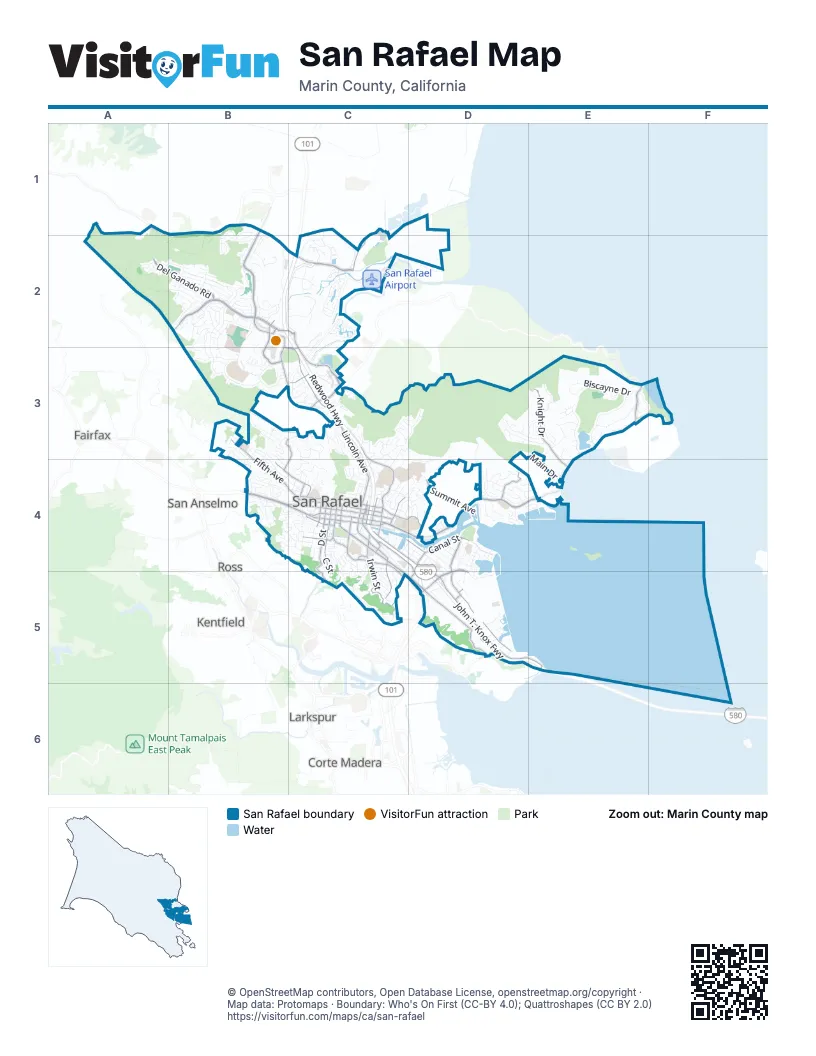
Street index of San Rafael
Each street on the sheet and the grid squares it crosses.
- Redwood HighwayB2, C2, C3, C4, D4, D5
- John T. Knox FreewayC4, D4, D5, E5
- Villa AvenueC3
- Fourth StreetB4, C4
- Third StreetC4, D4
- Second StreetB4, C4
- Irwin StreetC4, C5
- Red Hill AvenueB4
- Sir Francis Drake Boulevard EastD5
- Point San Pedro RoadE3, D4, E4
- Andersen DriveC4, C5, D5
- Manuel T Freitas ParkwayB2, C2
- Las Gallinas AvenueB1, B2, B3, C3
- Smith Ranch RoadC1, C2
- Lincoln AvenueC3, C4
- Merrydale RoadB3, C3
- Francisco Boulevard WestC4, D4, D5
- Bellam BoulevardD4, D5
- Los Ranchitos RoadB3, C3
- Lucas Valley RoadA1, B1, B2, C2
- North San Pedro RoadC3, E3
- A StreetC4
- Hetherton StreetC4
- Del Presidio BoulevardB2
- Francisco Boulevard EastC4, D4, D5, E5
- Fifth AvenueB3, B4, C4
- Kerner BoulevardD4, D5
- Del Ganado RoadA2, B2
- Mission AvenueC4, D4
- Grand AvenueC3, C4
- Northgate DriveB2, B3
- Civic Center DriveC2, C3
- Knight DriveE3, E4
- Woodland AvenueC4, C5, D5
- D StreetC4, C5
- C StreetC4, C5
- Canal StreetC4, D4
- Du Bois StreetC4, C5
- Forbes AvenueB4, C4
- Manderly RoadD4
- B StreetC4
- 1st StreetC4
- Elizabeth WayB3, C3, B4, C4
- Union StreetC4
- Bayview StreetC4
- Lindaro StreetC4
- Tamalpais AvenueC4
- E StreetC4
- Summit AvenueD4
- H StreetC4
- Medway RoadD4
- Irene StreetD5
- Rice DriveC4
- Lovell AvenueC4
- Court StreetC4
- Main StreetE5
- Wolfe GradeC5
- Las Colindas RoadB2
- Yosemite RoadC2
- Bret Harte RoadC4, C5
- Biscayne DriveE3
- Montecillo RoadB2, B3
- Deer Valley RoadC1, C2
- Fairhills DriveC3, C4
- Nova Albion WayB2, B3
- Belle AvenueC4, D4
- Riviera DriveE3
- Tamarack DriveB2, B3
- Peter Behr DriveC3
- Peacock DriveE3
- Prospect DriveC3, C4
- San Pedro Ridge Fire RoadD3
- Devon DriveB3
- Coleman DriveC3, C4
- Mountain View AvenueC3, D3, C4
- Deer Park AvenueD4
- North AvenueC1, C2
- Jewell StreetC4, D4
- Clorinda AvenueB4, C4
- Terrace AvenueB4
- Esmeyer DriveB3
- Professional Center ParkwayB2, C2
- Main DriveC2, D3, E3, E4
- Rollingwood DriveD3, E3
- McInnis ParkwayC2, C3
- Spinnaker Point DriveD4
- Robert Dollar DriveC3, C4
- Maywood WayB3
- Highland AvenueC4, D4
- San Marino DriveE3
- Canyon Oak DriveB1, B2
- Robinhood DriveD3, E3
- Scettrini DriveC2, C3
- Corrillo DriveC3
- McNear DriveE3
- Margarita DriveD4
- Waterside CircleC2
- Lea DriveB2, B3
- Mann DriveD3, D4
- Avenue of the FlagsC2, C3
- Ridgewood DriveB3
- Lochinvar RoadD4
- Los Gamos DriveB2
- Dominican DriveC3
- Las Pavadas AvenueB2
- San Pedro CoveD4
- North Redwood DriveC1, C2
- Linden LaneC3, C4
- Cantera WayE3, F3
- Locust AvenueD3, C4, D4
- Trellis DriveB2, B3
- Bungalow AvenueC4, C5
- Las Raposas RoadB2
- Lucas Park DriveB2
- Convent CourtC3
- Elda DriveB2, B3
- Golden Hinde BoulevardB3
- Mariners CircleC2
- Glen Park AvenueC3
- Cresta DriveC2
- Southern Heights BoulevardC4, C5
- Bamboo TerraceB2
- Santa Margarita DriveB4
- Miramar AvenueC4
- Bay WayD4
- Baypoint DriveD4, D5
- El Faisan DriveB3
- Chula Vista DriveC3
- Kinross DriveD4
- Center StreetB4, C4
- Upper Toyon DriveB4, C4, C5
- Marin Bay Park CourtE3, F3
- Butternut DriveB2
- Laurel PlaceC4
- Village CircleC3
- Las Ovejas AvenueB2
- Surrey LaneB2
- Palm AvenueC4, D4
- Silveira ParkwayC2
- Valley View AvenueC3
- Holly DriveB2
- Greenfield AvenueB4
- Belvedere StreetD4, D5
- Twelve Oak Hill DriveB1, B2
- Bahia WayD4
- Inverness DriveD4
- Orange Blossom LaneB2
- Oakmont AvenueC3
- Hillside AvenueB4
- Los Gamos RoadB2
- Woodbine DriveB2
- Arias StreetB2
- Blossom DriveC5
- Shoreline ParkwayD5
- Cedar Hill DriveB1, B2
- Wimbledon WayB3, B4
- Marin StreetC4
- Thorndale DriveB2, B3
- Reservoir RoadC4
- Mitchell BoulevardC2
- Elena CircleB2
- Meyer RoadC4, C5
- Hickory LaneB2
- Baywood TerraceC5
- Fair DriveC3
- Solano StreetB3, B4
- Duran DriveA2, B2
- Maplewood DriveE3
- Woodside WayE3
- Humboldt StreetB3, B4
- Magnolia AvenueC4, D4
- Catalina BoulevardD4, D5
- Rafael DriveC4
- Graceland DriveC4
- Larkspur StreetD4
- Oleander DriveB2
- Paul DriveC2
- Jordan StreetC4
- Arguello CircleD4
- Redding WayC5
- Laurel Glen TerraceC3
- G StreetC4
- Brentwood DriveE3
- Heritage DriveE3
- El Cerrito AvenueC4
- Skyview TerraceB2
- Forest LaneB2
- Marinita AvenueC4
- Hepburn Heights RoadB4
- Greenwood AvenueB4, C4
- Bridgewater DriveC2
- Junipero Serra AvenueD4
- Glacier PointD5
- Marina BoulevardD4
- Oakdale AvenueC3, D3
- Patricia WayB2
- Alexander AvenueB4
- Dunfries TerraceD4, E4
- Clark StreetC4
- Bellevue AvenueD4
- Upper Oak DriveB1, B2
- Wakerobin LaneB2
- Madera StreetD5
- Las Casas DriveD4
- Ross StreetC4
- San Rafael AvenueC4
- Picnic AvenueC4
- Cottonwood DriveE3
- Penny Royal LaneB2
- Balboa AvenueD4
- Meridian LaneC3
- Sea WayD4
- Vera Schultz DriveC3
- Nye StreetC4
- Gable CourtC2, C3
- Surfwood CircleE4
- El Pavo Real CircleB3
- Martens BoulevardC4
- Locksly LaneD4
- Spring Grove AvenueB4
- Billou StreetC4, C5
- Crestwood DriveB3
- Pine LaneB2
- Orchid DriveB2
- East Crescent DriveB4
- Scenic AvenueB4, C4
- Jacoby StreetD5
- San Pablo AvenueC3
- Tarragon DriveB2
- Bayo Vista WayB4
- Channing WayC2
- Windsor AvenueB3
- Park StreetC4, D4
- Bryce Canyon RoadC2
- Tamal Vista DriveB4
- Novato StreetD4
- Twin Oaks AvenueC4
- Playa del ReyD4, D5
- Wolfe AvenueC4, C5
- Knollwood DriveE3
- Montevideo WayB2
- Briarwood DriveE3
- Salvador WayB2
- Whitewood DriveB2
- Silk Oak CircleE3
- Dorian WayD4
- Gary PlaceD5
- Maple Hill DriveB2
- El Prado AvenueC3
- Sunset WayB4
- Upper Fremont DriveB4
- Front StreetC4, D4
- Mill StreetC4, D4
- Courtright RoadC4, C5
- Ridge AvenueC4
- Castlewood DriveE3
- Bret Harte LaneC5
- Lagoon RoadE3
- Partridge DriveE3
- Park Ridge RoadB2
- La Crescenta WayD4
- Las Flores AvenueC3
- Knocknaboul WayB2
- Brodea WayD4
- Loch Lomond DriveD4, E4
- Elm StreetC4
- Orris TerraceB2
- Hibiscus WayB2
- Miraflores AvenueC4
- Culloden Park RoadC4
- Alpine StreetB3
- De la Guerra RoadA2
- McCoy RoadC5
- Sylvia WayB2
- Fernwood WayE3
- Fairfax StreetD4
- Cedar LaneD4
- L. Nibbi DriveC2
- Terradillo AvenueC4
- Wisteria WayB2
- Lochness LaneD4, E4
- Vista del MarD4
- Ross Valley DriveB4
- Yacht Club DriveC4
- Gloria DriveB4, C4
- Pelican WayD5
- Live Oak WayC4
- Sequoia RoadC3
- Chestnut AvenueB3, B4
- Moody CourtB3
- Acacia AvenueC4
- Armory DriveC3
- Albert Park LaneC4
- Embarcadero WayD4
- Terra Linda DriveB3
- Cresta WayC2
- Longwood DriveB3, B4
- West Crescent DriveB4
- Bonnie Banks WayD4, E4
- River Oaks RoadB3, B4
Things to do on the San Rafael map
Places on the map
- Albert Park
- Boyd Memorial Park
- Civic Center Duck Pond
- Del Ganado Shopping Plaza
- Dominican Nature Preserve
- Driving range
- East Marin Island
- FedEx
- Grove Hill
- Harry A Barbier Memorial Park
- Hartzell Park
- James B Davidson Middle School
- Jerry Russom Memorial Park
- Kaiser Permanente San Rafael Medical Center
- Lagoon Park
- Marin Academy
- Marin County Library
- Marin County Sheriff
- Marin Islands Ecological Reserve
- Marin Islands National Wildlife Refuge
- Marin Resource Recovery Center
- Marin Tennis Club
- Mark Day School
- McInnis Golf Course
- McNears Beach County Park
- Mission Rafael Post Office
- Montecito Plaza
- Moore Hill
- Mount Olivet Cemetery
- Mount Tamalpais Cemetery
- Mountain Park
- Northgate III Shopping Center
- Northgate Mall
- Peacock Gap Golf Country Club
- Peacock Lagoon
- San Rafael Airport
- San Rafael Bay
- Terra Linda - Sleepy Hollow Open Space Preserve
- Terra Linda High School
- West End San Rafael Open Space
Next to San Rafael
- Corte Madera
- Fairfax
- Kentfield
- Larkspur map
- Ross
- San Anselmo map
© OpenStreetMap contributors, Open Database License, openstreetmap.org/copyright · Map data: Protomaps · Boundary: Who's On First (CC-BY 4.0); Quattroshapes (CC BY 2.0)















