

California map
Sanger map
About 26,649 people live here (Census Bureau, 2024 estimate). The sheet's index lists 178 streets; Academy Avenue, 3rd Street and Bethel Avenue cross the most grid squares. Also on it: Sanger High School, John F. Kennedy and Sanger Academy Charter School.
Open the map (PDF, US Letter)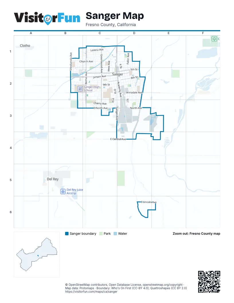
Street index of Sanger
Each street on the sheet and the grid squares it crosses.
- 2nd StreetB1, C1, D1
- 3rd StreetB1, C1, D1, C2
- Atchison AvenueB1, C1
- Camelia AvenueB1, B2
- Casty CourtB1, C1
- Church AvenueB1, C1, D1
- Dalton AvenueB1, B2, B3
- East Church AvenueB1
- Fenmore AvenueB1, B2, B3
- Florence AvenueB1, C1, D1
- Geary AvenueB1, C1, D1
- Glenview AvenueB1
- Holt AvenueB1, C1, D1
- Jenni AvenueB1, C1, B2
- North Dalton AvenueB1
- Pinewood AvenueB1, B2
- Reagan AvenueB1, B2
- Rosewood AvenueB1, B2
- South Indianola AvenueB1, B2
- Spencer AvenueB1, C1
- Sterling AvenueB1, C1, D1
- Tamarack AvenueB1, C1, D1
- Acacia AvenueC1
- Acacia DriveC1
- Academy AvenueC1, C2, D2, C3, D3
- Bethel AvenueC1, B2, C2, C3
- Brehler AvenueC1, C2, C3
- Canal DriveC1
- Claremont AvenueC1, C2
- East California AvenueC1, D1
- Eileen AvenueC1
- Fink AvenueC1
- Florence CourtC1
- Greenwood AvenueC1, C2, C3
- Hawley AvenueC1, C2
- Hill AvenueC1
- Kelli AvenueC1
- Lily AvenueC1, B2, C2, C3
- Lorena AvenueC1
- Lynn CourtC1
- Lyon AvenueC1, C2, C3
- Meierwood AvenueC1
- North Cottle AvenueC1
- North Post AvenueC1
- O StreetC1, C2, C3
- Oak AvenueC1
- Oatman AvenueC1, C2
- Post AvenueC1
- Post StreetC1, C2
- Santa Barbara AvenueC1
- Santa Cruz AvenueC1
- Santa Maria AvenueC1
- Santa Monica AvenueC1
- Santa Monicaa AvenueC1
- Sarah AvenueC1
- Sequoia AvenueC1, D1
- South Academy AvenueC1, C3, C4
- South Bethel AvenueC1
- South Fairbanks AvenueC1
- Tait AvenueC1, C2
- Wathen AvenueC1
- West AvenueC1, C2
- 2nd CircleD1
- 2nd CourtD1
- 4th StreetD1, B2, C2, D2
- Daisy LaneD1
- Faller AvenueD1, D2, D3
- Faller CourtD1
- Harrison AvenueD1, D2
- J StreetD1, D2, D3
- K StreetD1, D2, D3
- L StreetD1, D2
- Morton AvenueD1, D2
- Pearl StreetD1
- Quality AvenueD1, D2
- Recreation AvenueD1, D2
- Recreation CourtD1
- Redwood AvenueD1
- Segura AvenueD1, D2
- Tucker AvenueD1, D2, D3
- 14th StreetB2, C2
- 5th StreetB2, C2, D2
- 9th StreetB2, C2, D2
- Almond AvenueB2, C2, D2
- Carmella AvenueB2
- East Annadale AvenueB2, C2, D2
- East Jensen AvenueB2
- Hannah AvenueB2
- Indianola AvenueB2
- Jensen AvenueB2, C2, D2
- Magnolia AvenueB2, C2, D2
- Mary AvenueB2, C2
- Myrtle AvenueB2, C2
- Palm AvenueB2, C2, D2
- Sandra AvenueB2
- Sandra CourtB2
- Tenth AvenueB2
- Vine StreetB2, C2
- 10th StreetC2, D2
- 11th StreetC2, D2
- 12th StreetC2, D2
- 13th StreetC2
- 6th StreetC2
- 7th StreetC2, D2
- 8th StreetC2, D2
- Annadale AvenueC2, D2
- Circle DriveC2
- Cottle AvenueC2
- De Witt AvenueC2, C3
- George AvenueC2, C3
- Hoag AvenueC2, C3
- Mary StreetC2
- N StreetC2, D2
- P StreetC2, C3
- Park AvenueC2, C3
- Q StreetC2
- Rawson AvenueC2, C3
- Richard AvenueC2, C3
- Sanger AvenueC2, C3, D3
- Webster StreetC2
- Barbara AvenueD2
- Bennett WayD2
- Birch AvenueD2
- Carol AvenueD2
- Cypress AvenueD2
- Eastwood DriveD2
- Eleventh StreetD2
- Elizabeth AvenueD2
- Faller CircleD2
- Fir AvenueD2
- Forest LaneD2
- Grace AvenueD2
- Harriett AvenueD2
- Hume DriveD2, D3
- I StreetD2, D3
- Jefferson WayD2
- Mardros AvenueD2
- Millwood DriveD2, D3
- Olive AvenueD2, D3
- Rebeca AvenueD2
- Recreation CircleD2
- Rosa AvenueD2
- Simone WayD2
- South Newmark AvenueD2, D3
- South Rainbow AvenueD2
- Susan AvenueD2
- Virginia AvenueD2
- Cherry AvenueB3, C3, D3
- Edgar AvenueB3, C3, D3
- Gloria AvenueB3, C3, D3
- Moir AvenueB3, C3
- Walton AvenueB3, C3, D3
- Catherine AvenueC3
- Commerce AvenueC3, D3
- Diamond AvenueC3
- East Metzler DriveC3
- East North AvenueC3
- Heidi AvenueC3
- Hunter AvenueC3
- James StreetC3
- Kister StreetC3
- Lime AvenueC3
- Nile AvenueC3
- Orchid AvenueC3
- South Greenwood AvenueC3
- Swan AvenueC3
- West Metzler DriveC3
- Bennett StreetD3
- City Yard RoadD3
- Industrial WayD3
- KaiserD3, D4
- Muscat AvenueD3
- Newmark Ave / East Goodfellow AvenueD3, D4
- North AvenueD3
- South Channel RoadE3, E4
- South Ross AvenueE3
- East Central AvenueD4
- East Lincoln AvenueD6
Places on the map
- Acacia Park
- ARCO
- Audry Park
- Best Buy Liquor & Wine
- Brehler Square
- Cesar E. Chavez
- CVS Pharmacy
- Faller Park
- Fresno County Library, Sanger Branch
- Golden Living Center - Sanger
- Greenwood Park
- Holt Park
- Jackson Elementary School
- Jefferson Elementary School
- Jenni Park
- John F. Kennedy
- Lincoln Elementary School
- Lincoln Park
- Madison Elementary School
- RadioShack
- Ranch Market
- Rotary Ball Park
- Sanger Academy Charter School
- Sanger City Park
- Sanger Community Center
- Sanger Community Pool
- Sanger Fire Department
- Sanger High School
- Sanger Police Department
- Sanger Post Office
- Sanger Skate Park
- St. Mary's Catholic Church
- Taco Bell
- Taft High School
- The Church of Jesus Christ of Latter-day Saints
- Walmart Supercenter
- Washington Academic Middle School
- Westamerica Bank
- Wilson Elementary School
Next to Sanger
- Clotho
- Del Rey
© OpenStreetMap contributors, Open Database License, openstreetmap.org/copyright · Map data: Protomaps · Boundary: Who's On First (CC-BY 4.0); Quattroshapes (CC BY 2.0)















