

California map
Santa Maria map
About 111,346 people live here (Census Bureau, 2024 estimate). The sheet's index lists 300 streets; E Street, North Curryer Street and South Bradley Road cross the most grid squares. Things to do inside the boundary: Santa Maria Valley.
Open the map (PDF, US Letter)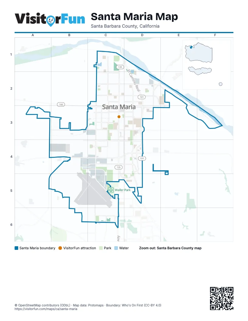
Street index of Santa Maria
Each street on the sheet and the grid squares it crosses.
- South Bradley RoadD3, D4, D5
- El Camino RealD1, D2, D3
- Orcutt ExpresswayD4, D5, D6
- Nicholson AvenueD3, D4
- South BroadwayD3, D4, D5
- West Betteravia RoadB4, C4, D4
- East Main StreetD3, E3, F3
- North BroadwayD1, D2, D3
- West Main StreetC3, D3
- East Betteravia RoadD4
- Skyway DriveC4, C5, D5
- Blosser RoadC3, C4, C6
- East Donovan RoadD2, E2
- West Stowell RoadB3, C3, D3
- South Blosser RoadC3
- Santa Maria WayD4, D5
- West Donovan RoadC2, D2
- Union Valley ParkwayC6, D6
- East Stowell RoadD3
- Lakeview RoadD5
- Miller StreetD3, D4, D5
- South College DriveD3, D4, D5
- North Blosser RoadC1, C2, C3
- McCoy LaneC4, D4, D5
- South Depot StreetC3, C4
- North College DriveD2, D3
- North Railroad AvenueC1, C2
- East Alvin AvenueD2, E2
- South Western AvenueC3, C4
- Battles RoadC4, D4
- East Fesler StreetD2, E2
- West Cook StreetC3, D3
- Suey RoadE2, E3
- Orcutt RoadD5, D6
- Panther DriveE2
- Sonya LaneC4, D4
- East Jones StreetD3, E3
- West Morrison AvenueC3, D3
- West Foster RoadC6, D6
- West Alvin AvenueC2, D2
- East Battles RoadD4
- East Cook StreetD3
- West Fesler StreetC2, D2
- Hanson WayC3
- Fairway AvenueC4
- Industrial ParkwayC4, C5
- Sunrise DriveD5
- Taylor StreetC1, D1, D2
- East Boone StreetD3
- Black RoadB3, B5
- East Enos DriveD3
- Mahoney RoadB4, B5
- North Depot StreetC2, C3
- Foxenwood LaneD6
- West Taylor StreetC1, D1
- Southside ParkwayD4
- Suey Crossing RoadE2
- California BoulevardC6
- Bull Canyon RoadE2
- East Foster RoadD6
- Siena LaneC4
- Fesler StreetC2
- Cook StreetD3
- South Thornburg StreetD3, D4
- North Western AvenueC1, C2, C3
- Carmen LaneC4, D4
- Cypress StreetC3, D3
- A StreetC3, C4, D4
- McElhany AvenueC2, D2
- E StreetB3, B4, D4, B5, B6
- Creston StreetC2, D2, E2
- North Miller StreetD2, D3
- Williams StreetC2, D2
- Dejoy StreetC1, C2
- Airpark DriveC5, D5
- Harding AvenueC2, D2, E2
- West Boone StreetC3, D3
- North McClelland StreetD2, D3
- Sunset AvenueC2, D2
- North Lincoln StreetD1, D2, D3
- South McClelland StreetD3, D4
- Westgate RoadC4
- Park AvenueC3, D3
- North Curryer StreetD1, C2, D2, C3
- Preisker LaneD1
- Mary DriveC2, C3
- North Thornburg StreetD2, D3
- North Bradley RoadD2
- North School StreetD2
- Hidden Pines WayC1, D1
- West El Camino StreetC2, D2
- Seaward DriveD1, D2, E2
- Mariposa WayC3, D3
- Lee DriveC2, D2, E2
- East El Camino StreetD2
- South Pine StreetD3
- West Church StreetC3, D3
- South Oakley AvenueC3, C4
- North Russell AvenueC2, C3
- Vine StreetD2, D3
- South Lincoln StreetD3, D4
- East Chapel StreetD2
- Palisade DriveD3, E3
- South Curryer StreetC3, C4
- North Pine StreetD2, D3
- North Palisade DriveE2, E3
- Hermosa StreetD2
- West Orchard StreetC2, D2
- East Camino ColegioD3
- East Orange StreetD3
- East Tunnell StreetD2
- North Oakley AvenueC2
- South Railroad AvenueC3
- South Smith StreetC3
- South Concepcion AvenueD3
- Dena WayD2, E2
- Carlotti DriveD1, D2
- Taft StreetC2, D2
- South Russell AvenueC3
- South East AvenueD3
- North Concepcion AvenueD2, D3
- West Orange StreetC3, D3
- East Newlove DriveD4
- North East AvenueD2
- Agnes AvenueC2, D2
- Donovan RoadC2, D2
- West Tunnell StreetC2, D2
- North Elizabeth StreetD2, D3
- Rose AvenueD2, E2
- Valerie StreetE2, E3
- Jewel StreetC2, D2
- Shepard DriveD3, D4
- Paden StreetD2
- Brian StreetE2, E3
- La Brea AvenueC3
- West Bunny AvenueC2, D2
- Concord AvenueE2, E3
- Bunny AvenueD2
- Oak StreetD3
- San Ysidro StreetD4, D5
- Inger DriveD4
- East Church StreetD3, E3
- Rancho VerdeC1
- West Grant StreetC2, D2
- Pershing StreetC3, D3
- Biscayne StreetC4
- Sierra Madre AvenueD3
- Central AvenueD3
- North Benwiley AvenueC2, C3
- San Miguel StreetD4, D5
- Canal StreetC1
- Lynne DriveD2
- West Enos DriveC3, D3
- Benwiley AvenueC2
- Lorencita DriveD5
- East Mill StreetD2
- South School StreetD3
- Bethel LaneC4
- Grant StreetD2
- Estes DriveD3, E3
- Mitchell RoadC6
- South Elizabeth StreetD3
- Via RosaC4
- West Mill StreetC2, D2
- West Chapel StreetC2, D2
- Barbara StreetD2, D3, D4
- Daniel DriveD4
- Gaylene DriveC2
- Knudsen WayC3
- Terminal DriveC5
- South Ranch StreetD3
- Del SurD4
- North Cesar E Chavez DriveC1
- Scott DriveD2, D3
- Arbor View CircleE2
- West Waller LaneC5, D5
- Speed StreetD3
- Dan Blough DriveC4
- Provance AvenueC4
- Caballero LaneD4
- Magellan DriveD2
- Walnut DriveD2, D3, D4
- Kingston DriveC2
- Lewis RoadD4
- Cox LaneC2, D2, E2
- Superior StreetC3
- Fairway Vista DriveC4
- StokesD2
- Evergreen AvenueC2, D2
- Santa Barbara DriveD5
- West Monroe StreetC2, D2
- Polk StreetC2, D2
- Ray RoadA3
- Wallis AvenueD3, C4, D4
- Air Park DriveC4, C5
- Ocotillo AvenueD4, D5
- Orchard StreetD2
- Blue Ridge DriveD5
- Marsala AvenueC4
- Professional ParkwayD4
- West Hermosa StreetC2, D2
- Monroe StreetD2
- Winston DriveC2
- Elm AvenueD2
- Palm Court DriveD3
- West Las Flores WayC3
- Saint Andrews WayC4, D4, D5
- Camino ColegioC3
- Garnet WayD2, E2
- Kensington AvenueD2
- Colebrook DriveC2
- Thompson WayC4
- Roemer WayD1
- Teelynn AvenueC1
- Juleston DriveC1
- Via QuanticoE2
- North Bentley AvenueC1
- McCloud StreetD5
- Sequoia DriveD4
- Bay AvenueD2
- Monterey RoadD5
- Bonita StreetD2, D3
- Barrett StreetC3
- Greenacre DriveD5
- Dal Porto LaneC4, D4
- East Las Flores WayD3
- Marian DriveE3
- Centerpointe ParkwayD4
- Woodlawn DriveC1, C2
- Bunfill DriveD5
- Pergola StreetC4
- Heritage WayC4
- Stacy Ann TerraceD5
- Turtle Creek DriveD5
- Lincoln StreetD4
- Olive DriveD4
- Oxford AvenueD2
- Meehan StreetD4
- Via AsuetoE2
- Bluebird StreetD3
- North Lucas DriveD2
- La Costa DriveC4
- Christina StreetD2
- Stonebridge DriveD2, E2
- Hawthorn StreetC1, D1
- Meredith LaneC4
- Johnson DriveD1
- North Smith StreetC2, C3
- Liberty StreetC3, D3
- Vickie AvenueD2
- Canyon DriveE2
- Capitol DriveD3
- Jackie LaneD3
- West Jones StreetD3
- Blue Sage LaneC4
- Gunner StreetC2
- East Morrison AvenueD3
- Stardust DriveD5
- De Armond PlaceD3
- Emerald DriveD2, E2
- Golden DriveC2
- Centennial StreetE2
- Central Park DriveD1
- Laguna AvenueD3
- Furukawa WayC3
- Plaza DriveD3
- Lexington AvenueC1
- Banyan WayD4, D5
- Country Club Village DriveC4
- Nightshade LaneD4
- Rowland DriveE2
- Alison AvenueC2
- Hawkins WayD4, D5
- Channel DriveD1
- Sapphire DriveD2, E2
- Mogul AvenueC1
- Bello RoadD4
- Rosewood DriveC2
- Stanford DriveD2
- Vista del RioC1
- Auto Plaza DriveD4
- Marilyn WayE3
- Trinity DriveC4
- Coral DriveE2
- Elaine AvenueC4
- East Cox LaneD2
- Grapevine RoadD2
- Tyler DriveE2
- Pabst LaneD6
- Siler LaneD6
- Townsend LaneD6
- Harsin LaneD6
- Vista MontanaC1
- Avenida RedondoC1
- Fiesta WayC1
- Lazo WayC1
- Rod DriveD5
- Arriba WayC1
- Via CarroC1
- Via Establo AvenueC1
Things to do on the Santa Maria map
Places on the map
- Abel Maldonado Community Youth Center
- Abel Maldonado Youth Center
- Acquistapace Park
- Adam Park
- Betteravia Government Center
- Bill Libbon Elementary School
- Broadway Pavilion
- Broadway Plaza Center
- College Square
- Enos Ranch
- First Christian Church
- Jim May Park
- Marian Medical Center
- Minami Park
- North Broadway Plaza
- Peppertree Plaza
- Pioneer Park
- Pioneer Valley High School
- Preisker Park
- Robert Bruce Elementary School
- Rosalind Perlman Park
- Rotary Centennial Park
- Santa Maria Cemetery
- Santa Maria Commons
- Santa Maria Country Club
- Santa Maria Court Complex
- Santa Maria Fairpark
- Santa Maria High School
- Santa Maria Public Airport
- Santa Maria Public Library
- Santa Maria Shopping Center
- Santa Maria Town Center Mall
- SMKA Kart Track
- Stowell Center
- Sunset Ridge Golf Course
- Taylor Elementary School
- The Crossroads at Santa Maria
- Tommie Kunst Junior High
- Town Center West
- Valley Christian Academy
© OpenStreetMap contributors, Open Database License, openstreetmap.org/copyright · Map data: Protomaps · Boundary: Who's On First (CC-BY 4.0); Quattroshapes (CC BY 2.0)















