

California map
Stockton map
About 324,975 people live here (Census Bureau, 2024 estimate). The sheet's index lists 198 streets; Westside Freeway, North El Dorado Street and South Airport Way cross the most grid squares. Also on it: Abbey Pointe Apartments, Almanor Circle and Alto Ingredients.
Open the map (PDF, US Letter)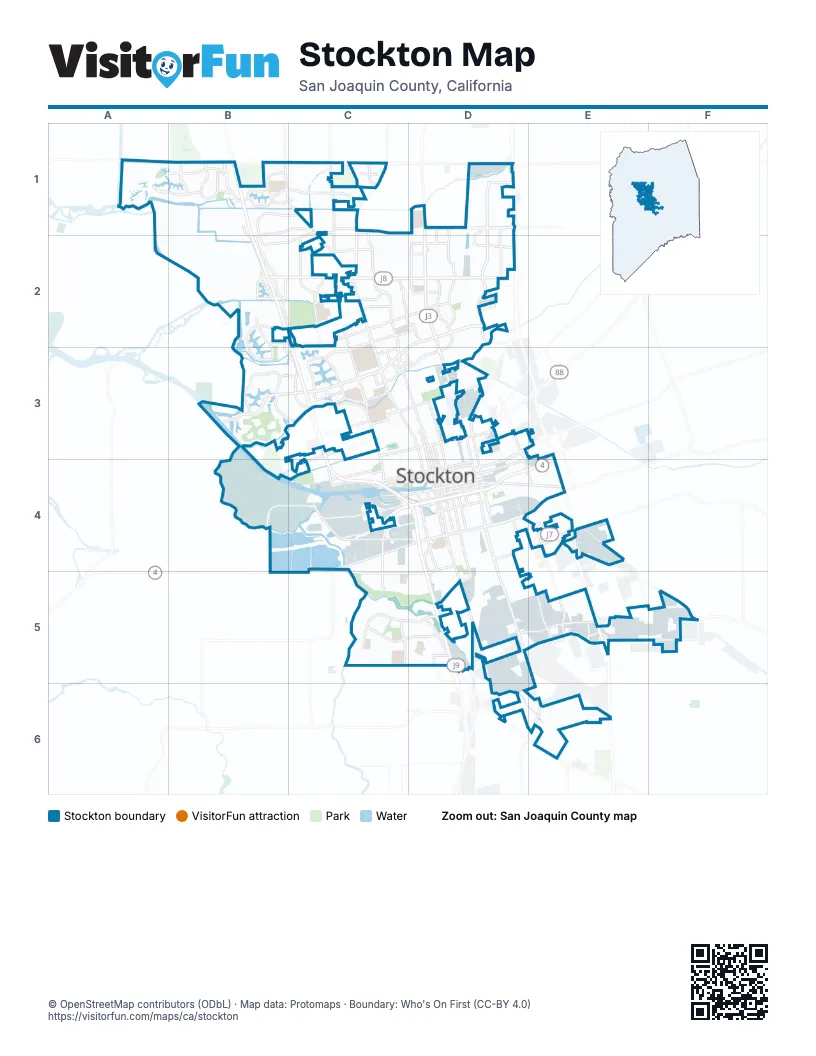
Street index of Stockton
Each street on the sheet and the grid squares it crosses.
- West Eight Mile RoadA1, B1, C1
- Westlake DriveA1, B1
- A G Spanos BoulevardB1, C1
- Cosumnes DriveB1
- Estate DriveB1, C1, B2
- Iron Canyon CircleB1
- Mariners DriveB1, B2
- McAuliffe RoadB1
- Mokelumne CircleB1
- Regatta LaneB1
- Scott Creek DriveB1
- Stanfield DriveB1, C1, B2
- Thornton RoadB1, C1, C2
- Trinity ParkwayB1
- Westside FreewayB1, B2, C2, C3, C4, D4, D5
- Whistler WayB1, C1
- Davis RoadC1, C2
- East Eight Mile RoadC1, D1
- Lower Sacramento RoadC1
- Marlette RoadC1
- Morada LaneC1, D1
- North El Dorado StreetC1, C2, C3, D3, D4
- North Lower Sacramento RoadC1, C2
- Royal Oaks DriveC1
- Villa PointC1
- Wagner Heights RoadC1, B2, C2
- 99 Frontage RoadD1, D2, E5
- Caywood DriveD1, D2
- Cherbourg WayD1, D2
- East Morada LaneD1
- Glacier Point DriveD1, D2
- Holman RoadD1, D2
- Maranatha DriveD1, D2
- West LaneD1, D2, D3
- Cumberland PlaceB2, B3
- Embarcadero DriveB2, B3
- Grigsby PlaceB2
- Kelley DriveB2
- Lighthouse DriveB2
- Morgan PlaceB2, B3
- Plymouth RoadB2, C2, C3
- Richland WayB2
- Schooner DriveB2
- Shoreline DriveB2
- West Benjamin Holt DriveB2, C2
- West Hammer LaneB2, C2
- West Swain RoadB2, C2
- Alexandria PlaceC2
- Don AvenueC2
- Douglas RoadC2
- East Hammer LaneC2, D2
- East Robinhood DriveC2, D2
- East Swain RoadC2, D2
- Hemet AvenueC2
- Kermit LaneC2, D2
- Lan Ark DriveC2
- Meadow AvenueC2
- Murillo DriveC2
- North Pacific AvenueC2, C3, D3
- North Pershing AvenueC2, C3, C4
- Pacific AvenueC2, C3
- Ponce de Leon AvenueC2
- Prado WayC2
- West Lincoln RoadC2
- West Robinhood DriveC2, C3
- Burgundy DriveD2
- Castle Oaks DriveD2
- East Bianchi RoadD2, C3, D3
- East March LaneD2, C3, D3
- East McAllen RoadD2
- East Sandalwood DriveD2
- Elaine DriveD2
- Hammertown DriveD2
- Holiday DriveD2
- Inspiration DriveD2
- Lorraine AvenueD2
- Montauban AvenueD2
- Prospector DriveD2
- Sandalwood DriveD2
- Tam O Shanter DriveD2
- West Lane Frontage RoadD2
- Brookside RoadB3, C3
- Buckley Cove WayB3
- Driftwood PlaceB3, C3
- Feather River DriveB3, C3
- Fourteen Mile DriveB3
- Riverbrook DriveB3
- West March LaneB3, C3
- Alpine AvenueC3, D3
- Claremont AvenueC3
- Country Club BoulevardC3
- Da Vinci DriveC3
- East Jamestown StreetC3
- Grouse Run DriveC3
- Jamestown StreetC3
- Kentfield RoadC3, D3
- McGaw StreetC3
- North Kensington WayC3
- North Ryde AvenueC3
- Precissi LaneC3
- Quail Lakes DriveC3
- River DriveC3
- Rose Marie LaneC3
- Sousa StreetC3
- Venezia BoulevardC3
- West Bianchi RoadC3
- West Harding WayC3, D3
- West Jamestown StreetC3
- West Mendocino AvenueC3
- West Yokuts AvenueC3
- Cherokee RoadD3
- East Fremont StreetD3, E3, D4
- East Harding WayD3
- North Airport WayD3, D4
- North California StreetD3, D4
- North Center StreetD3, D4
- North Filbert StreetD3, D4
- North Hunter StreetD3, D4
- North Madison StreetD3, D4
- North San Joaquin StreetD3, D4
- North Sanguinetti LaneD3
- North Wilson WayD3, D4
- Waterloo RoadD3
- West Cleveland StreetD3
- East Myrtle StreetE3, D4, E4
- Golden State HighwayE3, E4, E5
- McCloy AvenueB4, C4
- Port of Stockton ExpresswayB4
- Crosstown FreewayC4, D4, E4
- Monte Diablo AvenueC4
- Navy DriveC4, D4
- Picardy DriveC4
- Ryde AvenueC4
- South Fresno AvenueC4, C5
- West Charter WayC4, D4
- West Fremont StreetC4, D4
- West Oak StreetC4, D4
- West Park StreetC4, D4
- West Washington StreetC4, D4
- West Weber AvenueC4, D4
- California StreetD4, D5
- Charter WayD4, E4
- East 8th StreetD4, E4
- East Charter WayD4
- East Hazelton AvenueD4
- East Lafayette StreetD4
- East Main StreetD4, E4
- East Market StreetD4
- East Miner AvenueD4
- East Oak StreetD4
- East Park StreetD4
- East Washington StreetD4
- East Weber AvenueD4
- French Camp TurnpikeD4
- Mariposa RoadD4, E4, F5
- North Lincoln StreetD4
- North Stanislaus StreetD4
- Old U.S. Route 99ED4
- Old U.S. Route 99WD4, D5, E6
- South Airport WayD4, D5, E5, E6
- South Aurora StreetD4
- South B StreetD4, E5
- South California StreetD4
- South Center StreetD4
- South El Dorado StreetD4
- South Filbert StreetD4, E4
- South Hunter StreetD4
- South Lincoln StreetD4
- South Madison StreetD4
- South San Joaquin StreetD4
- South Stanislaus StreetD4
- South Stockton StreetD4
- South Wilson WayD4
- Turnpike RoadD4, D5
- West 8th StreetD4, C5, D5
- West Hazelton AvenueD4
- West Lafayette StreetD4
- 8th StreetE4
- East Munford AvenueE4
- Farmington RoadE4
- Pock LaneE4, E5
- Carolyn Weston BoulevardC5, D5
- E.W.S. Woods BoulevardC5
- French Camp RoadC5, D5
- William Moss BoulevardC5, D5
- Arch Airport RoadD5, E5
- Boeing WayD5, E5
- Downing AvenueD5
- Manthey RoadD5
- McKinley AvenueD5
- South French Camp RoadD5
- Sperry RoadD5
- Arch RoadE5, F5
- Kingsley RoadE5
- Qantas LaneE5
- Transworld DriveE5
- Austin RoadF5
- East Mariposa RoadF5
Places on the map
- Abbey Pointe Apartments
- Almanor Circle
- Alto Ingredients
- Amazon SCK1
- Amazon SMF3
- Amberfield Circle
- American Legion Park
- Anderson Park
- Angel Cruz Park
- Ansel Adams Elementary School
- Arnaiz Stadium
- Atherton Park
- Atlanta Circle
- Atlas Tract
- Barbados Circle
- Barbaresco Circle
- Baxter Park
- Bay View Circle
- Bergamo Circle
- Black Butte Circle
- Bonaire Circle
- Boulder Creek Circle
- Bridgewater Circle
- Bridle Path Place Apartments
- Bridlewood Circle
- Brook Falls Circle
- Brook Valley Circle
- Brookside Country Club
- Brookside Field
- Brookside School
- Brookside Stockton
- Budd 1
- Budd 4
- Capitola Circle
- Caribbean Circle
- Carousel Circle
- Cathedral Circle
- Central Branch Stockton-San Joaquin County Public Library
- Charleston Place Apartments
- Chianti Circle
© OpenStreetMap contributors (ODbL) · Map data: Protomaps · Boundary: Who's On First (CC-BY 4.0)