

California map
Visalia map
About 146,271 people live here (Census Bureau, 2024 estimate). The sheet's index lists 300 streets; West Perez Avenue, West Riggin Avenue and West Vine Avenue cross the most grid squares. Things to do inside the boundary: Sequoia Tourism Council, Visalia Mall and Visit Visalia.
Open the map (PDF, US Letter)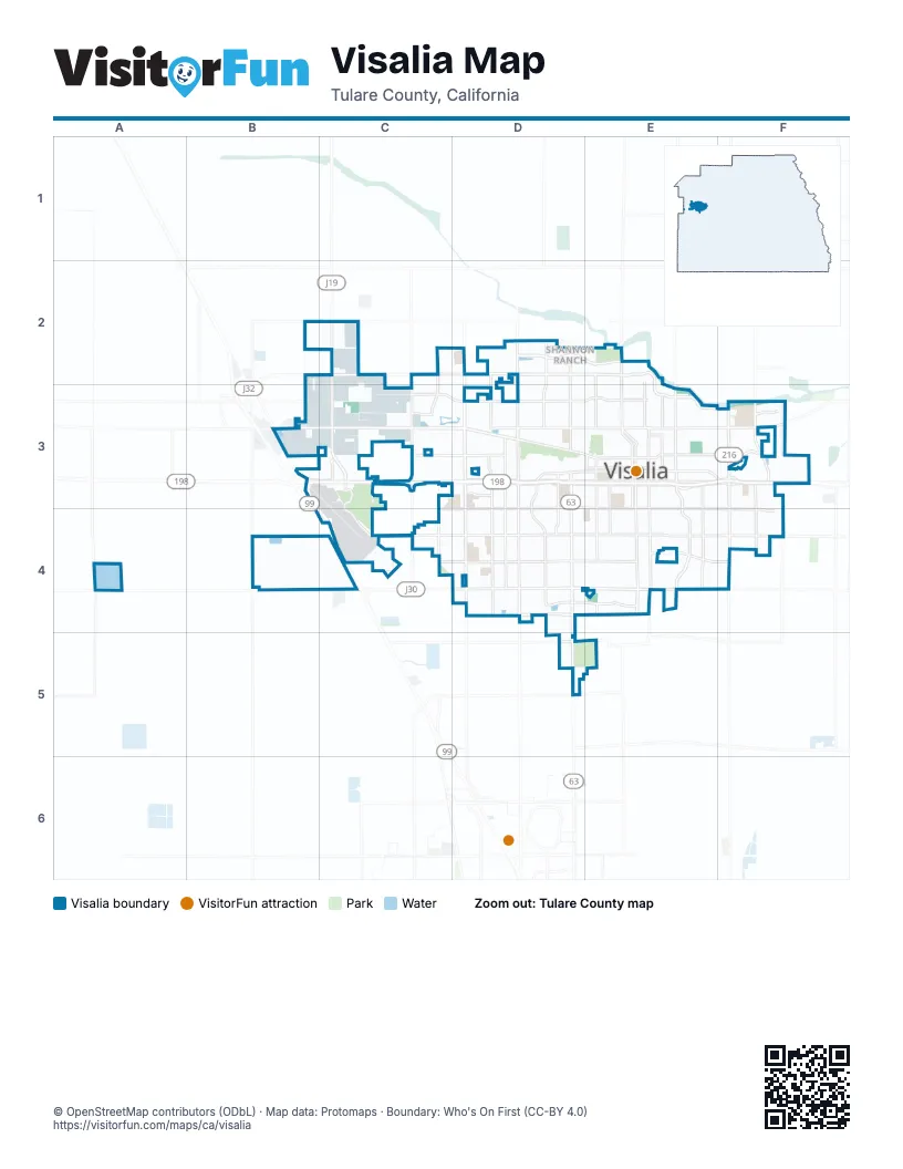
Street index of Visalia
Each street on the sheet and the grid squares it crosses.
- Golden State HighwayA4, B4
- West Riggin AvenueA2, B2, C2, D2, E2
- South Mooney BoulevardD3, D4, D5, D6
- West Caldwell AvenueB5, C5, D5, E5
- South Lovers LaneF3, F4, F5
- West Noble AvenueC3, D3, E3
- East Houston AvenueE3, F3
- Plaza DriveA2, A3, B3
- West Mineral King AvenueC3, D3, E3
- South Court StreetE3, E4, E5
- East Noble AvenueE3, F3
- North Plaza DriveA2
- East Caldwell AvenueE5
- East Mineral King AvenueE3, F3
- North Court StreetE2, E3
- North Lovers LaneF3
- North Dinuba BoulevardD2, D3
- South Locust StreetE3, E4, E5
- North Locust StreetE3
- North West StreetD3
- Mooney BoulevardD6
- Northwest 3rd AvenueD3, E3
- Northwest 2nd AvenueD3, E3
- Lincoln OvalE3
- Ivanhoe DriveF3
- West Goshen AvenueA3, B3, C3, D3
- West Walnut AvenueB4, C4, D4, E4
- South Akers StreetC3, C4, C5
- South Ben Maddox WayE3, E4, E5
- North Akers StreetC2, C3
- East Walnut AvenueE4, F4
- East Saint John's ParkwayE2, E3, F3
- South Demaree StreetC3, C4, C5
- West Houston AvenueC3, D3, E3
- North Demaree StreetC2, C3
- North Ben Maddox WayE2, E3
- North Saint John's ParkwayE2
- East Riggin AvenueE2
- Avenue 288A4, F4
- West Murray AvenueD3, E3
- North Demaree RoadC3
- Avenue 312B2
- Road 108C5
- West Ferguson AvenueB2, C2, D2, E2
- South Linwood StreetC3, C4, C5
- West Whitendale AvenueC4, D4, E4
- West Shannon ParkwayC2, D2
- West Tulare AvenueC4, D4, E4
- West Visalia ParkwayC5, D5
- South Chinowth StreetC3, C4, C5
- East Tulare AvenueE4, F4
- South County Center DriveD3, C4, D4, D5
- South Woodland StreetD3, D4, D5
- North Mooney BoulevardD2, D3
- South Santa Fe StreetE3, E4, E5
- South Pinkham StreetE3, E4, E5
- South Giddings StreetD3, D4
- West Main StreetD3, E3
- North Giddings StreetD2, D3
- County CenterD2, D3
- West Iris AvenueC4, D4
- West Cameron AvenueD5, E5
- North Shirk RoadB2, B3
- North McAuliff RoadF2, F3
- West Hurley AvenueB3, C3
- North Bridge StreetE2, E3
- East Main StreetE3
- South Conyer StreetD3, D4
- North Linwood StreetC2, C3
- Mineral King AvenueB3, F3
- North Burke StreetE2, E3
- South Plaza DriveB3, B4
- West Doe AvenueB3
- West Laurel AvenueC4, D4, E4
- East Goshen AvenueE3, F3
- North Chinowth StreetC2, C3
- East Mill Creek ParkwayF3
- West Cypress AvenueC3, D3, E3
- South McAuliff StreetF3, F4
- East K AvenueE4
- South Roeben RoadC3, C4
- Camp DriveA3
- East Center AvenueE3, F3
- West Center AvenueD3, E3
- North Roeben StreetB2, C2, B3, C3
- North Santa Fe StreetE3
- East Ferguson AvenueE2
- Pratt RoadC2, D2
- South Shirk RoadB3, B4
- East Roosevelt AvenueE3, F3
- Avenue 272D5
- East Murray AvenueE3, F3
- 1st AvenueC3
- East Shannon ParkwayD2, E2
- West Kibler AvenueA2
- North Hall StreetD2, D3
- Neeley RoadA3
- Road 148F4
- South Stonebrook StreetD4, D5
- Riverway DriveC2, D2
- Avenue 264D6
- Avenue 320A2
- Road 100C5
- South McAuliff RoadF3
- McAuliff RoadF2
- West Cambridge AvenueC4, D4
- West Prospect AvenueB3, C3, D3
- South Divisadero StreetD3, D4, D5
- West Vine AvenueD2, E2, B3, C3, D3
- South Crenshaw StreetC3, C4, C5
- West Buena Vista AvenueC3, D3, E3
- East Paradise AvenueE4, F4
- East Douglas AvenueE3, F3
- West Robin AvenueC2, D2, E2
- West Dorothea AvenueC4, D4
- West Modoc AvenueB2, C2, D2
- South Burke StreetE3, E4, E5
- West Sedona AvenueC2, D2
- West Howard AvenueC4, D4, E4
- West School AvenueB3, C3, D3, E3
- West Elowin AvenueB3, C3, D3
- West Sunnyview AvenueB2, C2, D2, E2
- West Myrtle AvenueC3, D3, E3
- West Grove AvenueA3, B3, C3, D3, E3
- West Vassar AvenueB4, C4, D4
- West Paradise AvenueC4, D4, E4
- West Victor AvenueC4, D4
- South West StreetD3, D4, D5
- West Oriole AvenueB2, C2, D2
- West Feemster AvenueC4, D4, E4
- West Perez AvenueB2, C2, D2, E2, C3, D3
- West Sweet AvenueB3, C3, D3, E3
- South Garden StreetE3, E4, E5
- West Sunnyside AvenueC4, D4
- South Encina StreetD3, D4, E4, D5, E5
- South Watson StreetD3, D4, D5
- West Delta AvenueC3, D3
- West Hillsdale AvenueB3, C3
- West Lark AvenueC2, D2
- West Monte Vista AvenueC4, D4
- West Ashland AvenueC4, D4
- North Conyer StreetD2, D3
- South Dollner StreetD3, D4, D5
- West la Vida AvenueC4, D4
- West Harold AvenueB3, C3, D3
- West Cherry AvenueB4, C4, D4
- West Glendale AvenueC2, D2
- South Church StreetE3, E4, E5
- West Wren AvenueC2, D2, E2
- East College AvenueE3, F3, E4, F4
- North Divisadero StreetD2, D3
- East Seeger AvenueE4, F4
- West Harter AvenueB4, C4, D4
- North Leila StreetC2, C3
- West Kaweah AvenueC3, D3
- South Bridge StreetE3, E4, E5
- North Ranch StreetD2, D3
- East Cherry AvenueE4, F4
- East Acequia AvenueE3, F3
- East Laurel AvenueE4, F4
- North Willis StreetD2, D3
- North Cain StreetE2, E3
- East Laura AvenueE4, F4
- North Turner StreetD2, D3
- North Jacob StreetD2, D3
- East Westcott AvenueE4, F4
- West Porter AvenueD2
- South Cain StreetE3, E4
- East Feemster AvenueE4, F4
- South University StreetC4, C5
- South Central StreetD3, D4
- East Buena Vista AvenueE2, E3
- South Sowell StreetD3, D4
- West Beech AvenueD4, E4
- South Linda Vista StreetD3, D4, D5
- East Harold AvenueE3, F3
- West Mary AvenueB4, C4, D4
- Kelsey StreetB3
- West Babcock AvenueB2, C2, D2, E2
- West Damsen AvenueB3, C3
- West Oak AvenueB3, C3, D3, E3
- West Laura AvenueB4, C4, D4, E4
- South Johnson StreetD3, D4
- West Judy AvenueB4, C4
- North Tommy StreetC2, C3
- North Preston StreetB2, B3
- West Elkhorn AvenueC5, D5, E5
- West Tyler AvenueC2, D2
- West Nicholas AvenueA3, C3
- West Kimball AvenueD5, E5
- East Cambridge AvenueE4, F4
- North Stevenson StreetD3
- West Prescott AvenueC2, D2
- South Redwood StreetD3, D4
- West Pershing AvenueA3, B3, C3
- West Country AvenueC4, D4
- West Evergreen AvenueC4, D4
- North Mendonca StreetC2, C3
- North Kent StreetC2, C3
- North Highland StreetD2, D3
- East Sweet AvenueE3, F3
- Aviation WayB4
- East Monte Verde AvenueE4
- East Race AvenueE3, F3
- North Encina StreetD2, D3
- Drive 85A4, B4
- South Stevenson StreetD3, D4
- South Verde Vista StreetD3, D4, D5
- West Stewart AvenueC3, D3
- East Mary AvenueE4, F4
- East la Vida AvenueE4, F4
- Claudio StreetD4
- West Robinwood AvenueB3, C3
- West Harvard AvenueC4, D4
- West Burrel AvenueD3
- West Grove CourtA3, C3
- South Silvervale StreetC4, C5
- North Garden StreetE2, E3
- West Payson AvenueC2, D2
- Ferguson AvenueA2, B2
- West Meadow AvenueC4, D4
- North Rinaldi StreetD2, D3
- West Princeton AvenueD4
- North Zachary StreetD2, D3
- North Church StreetE2, E3
- South Fulgham StreetC3, C4, C5
- Road 86B3, B4
- South Edison StreetE3, E4
- West Reese AvenueC5, D5, E5
- North Woodland StreetD2, D3
- Border Links DriveC3, D3
- East Myrtle AvenueE3, F3
- East Sunnyview AvenueE2, F2
- West Flagstaff AvenueC2, D2
- East Kaweah AvenueE3, F3
- West Douglas AvenueC3
- West Russell AvenueC5, D5
- Avenue 268D5
- West Campus AvenueC3, D3
- Road 88B2, B3
- South Kent StreetC3, C4, C5
- East Cypress AvenueE3, F3
- East Howard AvenueE4, F4
- West Cherry CourtC4, D4
- East Hillcrest AvenueE4, F4
- South Goddard StreetE3, E4
- Road 76A2, A3
- East Monte Vista AvenueE4, F4
- North Tilden StreetC2, C3
- North Vista StreetF3
- South Parkwood StreetC4, C5
- North Vickie StreetD2, D3
- West Hillsdale DriveC3, D3
- South Vista StreetF3, F4
- East Oak AvenueE3, F3
- East Vassar AvenueE4, F4
- South Oak Park StreetD3, D4
- North Rono StreetC2, C3
- South Bradley StreetE3, E4, E5
- North Kelsey StreetB2, B3
- South Jacob StreetD3, D4
- South Grand StreetF3, F4
- West Hemlock AvenueC4, D4
- West Packwood AvenueC5, D5
- South Martin StreetD3, D4
- Mill Creek DriveC3, D3
- North Manzanita StreetF3
- South Virmargo StreetE4, E5
- North Tipton StreetE3
- South Cedar StreetE4
- South Fairway StreetD4, D5
- North Virmargo StreetE2, E3
- West Orchard AvenueC4, D4
- North Crenshaw StreetC2, C3
- West College AvenueC3, D3, C4
- East Vine CourtE2, E3
- West Roosevelt AvenueB3, D3
- South Rio Vista StreetF3, F4
- West Sady AvenueC3, D3
- South Cotta StreetE4
- Green Acres DriveD3
- South Terrace StreetD4, D5
- North University StreetC2, D2, D3
- West Wren DriveD2
- West Vine CourtC2, B3, C3, D3
- South Bollinger StreetC4, C5
- Crowley AvenueA3, B3
- East School AvenueE3, F3
- East Stapp AvenueF3
- East Beech AvenueE4, F4
- West Clinton CourtB2, C2, D2
- South Thomas StreetE4
- West Dartmouth AvenueC4, D4
- North Liberty StreetE2, E3
- North Irma StreetE3
- North Fairway StreetD2, D3
- West Oakridge AvenueC2, D2
- Lakewood DriveC2, C3
- South Elverta StreetF3, F4
- MolenstraatC3, C4
Things to do on the Visalia map
Places on the map
- Adventure Park
- Amazon FAT2
- Blaine Park
- Crestwood Elementary School
- Derrel's Mini Storage
- Divisadero Middle School
- El Diamante High School
- Fairview Elementary School
- Fairview Village Park
- FedEx Office
- Four Creeks Elementary School
- Gateway Business Park
- Golden Oak Elementary School
- Golden West High School
- Green Acres Middle School
- Houk Park
- Kaweah Delta District Hospital Library
- Kaweah Delta Medical Center
- Kaweah Delta Sub Acute
- La Joya Middle School
- Linwood Elementary School
- Mary's Vineyard
- Mill Creek Park
- Modoc Ditch
- Mooney Grove Park
- Northside Shopping Center
- Packwood Creek Shopping Center
- Plaza Business Park
- Riverway Sports Park
- Sterling Oaks
- The Grove - Packwood Creek
- Tulare County Civic Center
- Valley Life Charter Schools
- Valley Oaks Golf Course
- Village West Shopping Center
- Visalia Cemetery
- Visalia Country Club
- Visalia Marketplace
Next to Visalia
- Goshen
© OpenStreetMap contributors, Open Database License, openstreetmap.org/copyright · Map data: Protomaps · Boundary: Who's On First (CC-BY 4.0); Quattroshapes (CC BY 2.0)















