

Colorado map
Aurora map
About 403,130 people live here (Census Bureau, 2024 estimate). The sheet's index lists 96 streets; E-470, South Powhaton Road and East Smoky Hill Road cross the most grid squares. Also on it: 21 Fitzsimons Apartment Homes, Abilene Market and Adonea.
Open the map (PDF, US Letter)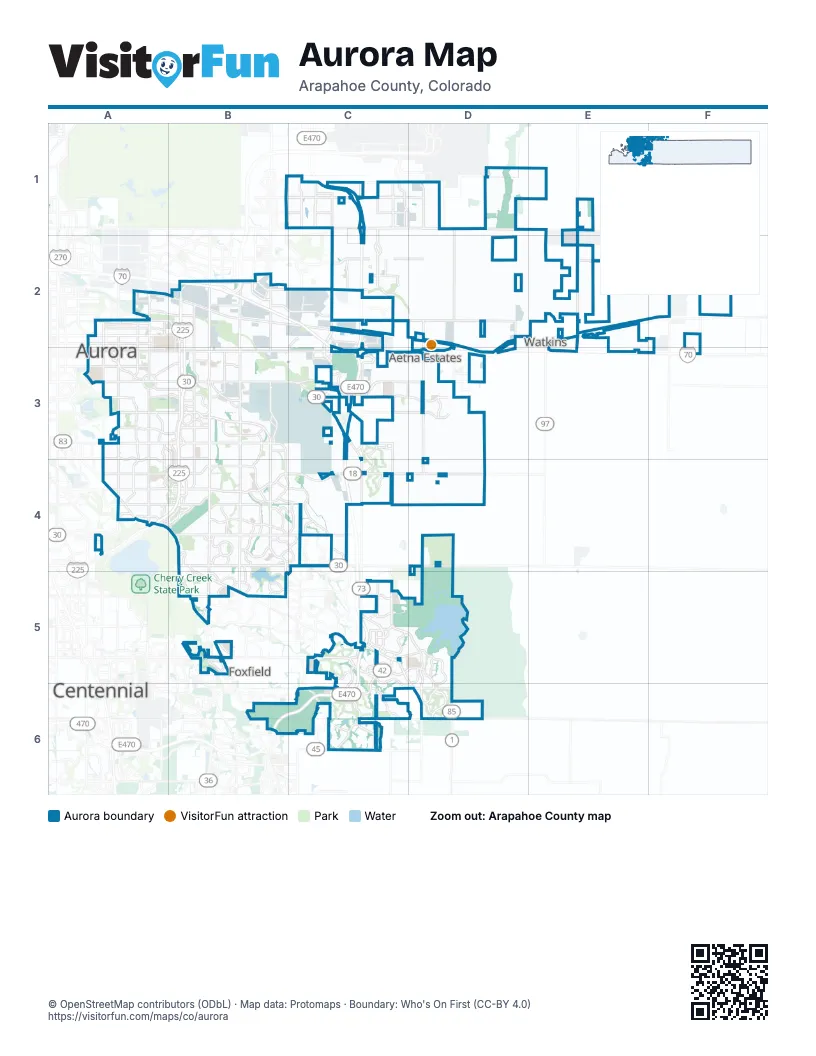
Street index of Aurora
Each street on the sheet and the grid squares it crosses.
- East 64th AvenueB1, C1
- East 56th AvemueC1
- East 56th AvenueC1, D1, E1
- North Jackson Gap StreetC1
- North Jackson Gap WayC1, D1
- North Picadilly RoadC1, C2, C3
- North Imboden RoadE1, E2
- East Martin Luther King Junior BoulevardA2
- East Montview BoulevardA2
- North Fitzsimons ParkwayA2, B2, B3
- North Havana StreetA2, A3
- North Peoria CrossingA2
- North Peoria StreetA2, A3
- Dwight D. Eisenhower HighwayB2, C2
- East 17th PlaceB2
- East 32nd ParkwayB2, C2
- East 38th AvenueB2, C2
- East 40th AvenueB2
- North Airport BoulevardB2, B3
- North Chambers RoadB2, B3
- North Tower RoadB2, B3
- Peña BoulevardB2
- Tuskegee Airmen Memorial HighwayB2
- E-470C2, C3, C4, C5, B6, C6
- East 26th AvenueC2
- East 48th AvenueC2, D2
- East The Aurora Highlands ParkwayC2
- North Denali BoulevardC2
- East 6th AvenueA3, B3, C3, D3
- East Alameda AvenueA3, B3
- East Colfax AvenueA3, B3, C3
- East Florida AvenueA3
- East Lowry BoulevardA3
- East Mississippi AvenueA3, B3
- North Del Mar Circle EastA3
- North Del Mar Circle SouthA3
- North Yosemite StreetA3
- South Havana StreetA3, A4
- South Peoria StreetA3, A4
- East Alameda ParkwayB3
- North Potomac StreetB3
- North Sable BoulevardB3
- South Abilene StreetB3, B4
- South Airport BoulevardB3
- South Buckley RoadB3, B4, B5
- South Chambers RoadB3, B4, B5
- South Dunkirk StreetB3, B4
- South Potomac StreetB3
- South Sable BoulevardB3, B4
- South Tower RoadB3, B4, B5
- East 14th AvenueC3
- East 6th ParkwayC3
- East State Highway 30C3
- East Stephen D. Hogan ParkwayC3
- North Gun Club RoadC3
- South Gun Club RoadC3, C4
- North Powhaton RoadD3
- South Powhaton RoadD3, D4, C5, D5, D6
- East Dartmouth AvenueA4
- East Iliff AvenueA4, B4
- East Yale AvenueA4, B4
- Honorable Gary McPherson Memorial FlyoverA4
- South Parker RoadA4, B4, B5, B6
- East Hampden AvenueB4, C4
- East Jewell AvenueB4, C4, D4
- East Quincy AvenueB4, C4, D4
- East Smoky Hill RoadB4, B5, C5, D5, D6
- South Atchison WayB4
- South Reservoir RoadB4, B5
- Copperleaf BoulevardC4
- South Himalaya StreetC4
- South Picadilly RoadC4
- South Picadilly StreetC4
- East Arapahoe RoadB5, C5, D5
- East Belleview AvenueB5, C5
- East Chenango DriveB5
- East Crestline DriveB5
- South Jordan RoadB5
- East Orchard RoadC5
- South Aurora ParkwayC5, C6
- South Gartrell RoadC5, C6
- South Harvest RoadC5
- South Liverpool StreetC5
- East Aurora ParkwayC6
- East Dry Creek RoadC6
- East Inspiration DriveC6
- East Inspiration LaneC6
- East Irish DriveC6
- Inspiration DriveC6
- South Sampson Gulch WayC6
- County Road 194D6
- East County Line RoadD6
- East County Road 50;County Road 194D6
- East Smoky Hill ParkwayD6
- North Delbert RoadD6
- South Monaghan RoadD6
Places on the map
- 21 Fitzsimons Apartment Homes
- Abilene Market
- Adonea
- Amazon DEN2
- Anchor Point Park
- Andover Glen
- Arapahoe Crossings Shopping Center
- Aspen Ridge Apartments
- Auburn Hill
- Aurora
- Aurora Cascades
- Aurora City Place
- Aurora East Planned Community
- Aurora East Village
- Aurora Highlands
- Aurora Hills
- Aurora Hills Golf Course
- Aurora ICE Processing Center
- Aurora Marketplace
- Aurora Meadows Apartments
- Aurora Reservoir
- Aurora South Soccer Complex
- Aurora Sports Park
- Bayberry Condominiums
- Blackstone Country Club
- Brandy Chase
- Buckingham Village
- Buckley Family Housing
- Buckley Space Force Base
- Burgundy at Heather Ridge
- Business Commons
- Cambrian Apartments
- Centerpoint
- CentrePointe Park
- Chaddsford
- Chambers Heights
- Cherokee
- Cherokee Trail High School
- Cherry Creek Racquet Club
- Cherry Grove East II
Next to Aurora
- Aetna Estates
- Centennial
- Foxfield
- Watkins
© OpenStreetMap contributors (ODbL) · Map data: Protomaps · Boundary: Who's On First (CC-BY 4.0)