

Colorado map
Castle Pines Village map
About 15,162 people live here (Census Bureau, 2024 estimate). The sheet's index lists 184 streets; Castle Pines Drive South, Castle Pines Drive North and Country Club Parkway cross the most grid squares. Also on it: Castle Pines Golf Club, The Country Club at Castle Pines and South Metro Fire Rescue District Station 39.
Open the map (PDF, US Letter)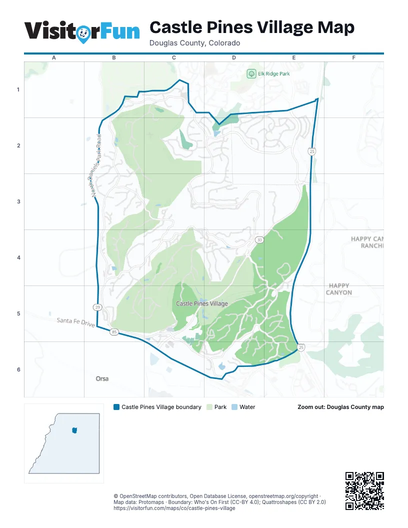
Street index of Castle Pines Village
Each street on the sheet and the grid squares it crosses.
- Country Club Estates DriveB1, C1, B2
- Country Club ParkwayB1, C1, B2, C2, B3, B4
- Northwood LaneB1, C1
- Westchester CircleB1
- Ellingwood Point PlaceC1, D1, C2, D2
- Handies Peak CourtC1, C2
- Large Oak CourtC1
- Northwood CourtC1
- Preston CourtC1
- Preston WayC1
- Braylin LaneD1, D2
- Clara PlaceD1, D2
- Kenzie CircleD1, E1, D2, E2
- Cortona PlaceE1
- Edge View CircleE1, E2
- Edge View RoadE1, E2
- Lagae RoadE1, D2, E2, E3
- AnacondaB2, B3, C3
- Anaconda DriveB2, B3
- Aztec DriveB2
- Cypress WayB2
- Good Hope DriveB2, B3
- Homestake CourtB2
- Meteor PlaceB2
- Night Sky CourtB2
- North Daniels Park RoadB2, B3, B4, B5
- Swandyke DriveB2
- Utica DriveB2, B3
- Vintage PlaceB2
- Wolverine CourtB2
- Country Club DriveC2, D2, C3, D3, D4
- Ellingwood Point WayC2, D2
- Holy Cross LaneC2, D2
- Huron LaneC2, D2
- Huron PlaceC2
- Maroon Peak PlaceC2
- Massive Peak CircleC2
- Massive Peak LoopC2
- Missouri Peak PlaceC2
- Windom Peak WayC2
- Chase LaneD2, E2
- Chloe CourtD2
- el Diente Peal PlaceD2
- Holy Cross WayD2
- Medera WayD2
- Oxford Peak CourtD2
- Oxford Peak LaneD2, C3, D3
- Oxford Peak PlaceD2
- Rockingham CourtD2, E2
- Shavano Peak PlaceD2
- Shavano Peak WayD2
- Stinson PlaceD2, E2
- Dukes TrailE2
- Edge View LaneE2
- Hampshire LaneE2
- Merrimack DriveE2
- Merrimack PlaceE2
- Rockingham CircleE2
- Rockingham WayE2
- Steuben CourtE2
- Steuben WayE2
- Anaconda CourtB3
- Dakota DriveB3
- Diablo WayB3
- Dinero PlaceB3
- Equinox DriveB3, C3, C4
- Glengarry PlaceB3, C3
- Hidden Valley LaneB3
- Klondike PlaceB3
- Lead King DriveB3
- Lead Queen DriveB3
- Moffat CourtB3
- Morgan PlaceB3, B4
- Saratoga Mine DriveB3
- Saratoga Vein CourtB3
- Swandyke CourtB3
- Capulin PlaceC3, B4, C4
- Castle Pines Drive NorthC3, D3, B4, C4, D4, B5, C5
- Cliffgate LaneC3, D3
- Cliffside CourtC3
- Duncan PlaceC3
- Fairway View CourtC3
- Tournament DriveC3, C4, D4
- Borealis WayD3, D4
- Eclipse PlaceD3
- Golden Bear LaneD3
- Lindsey Peak LaneD3
- Mount Sneffels PlaceD3
- East Happy Canyon RoadE3, D4, E4
- Crown Point PlaceB4
- Evening Star CourtB4
- Evening Star DriveB4, B5
- Evening Star LaneB4
- Golf Club DriveB4, B5
- Lost Trail DriveB4, B5, C5
- Ramshorn DriveB4
- Silver Leaf WayB4
- Avon PlaceC4
- Castle Brook DriveC4
- Castle Glen CourtC4
- Castle Glen DriveC4
- Castle Glen PlaceC4
- Champion PlaceC4
- Comstock PlaceC4
- Coulter PlaceC4
- Crestone WayC4, C5
- Hummingbird DriveC4, D4, C5
- Tournament CourtC4
- Albion PlaceD4
- Bantala PlaceD4
- Castle Pines Drive SouthD4, E4, C5, D5, E5, C6, D6, E6
- Columbine PlaceD4
- Country Club LaneD4
- Glenalla PlaceD4
- Indigo WayD4
- Ridge Plaza DriveD4
- Roca PlaceD4, E4, D5
- Starmine PlaceD4
- Titan PlaceD4
- West Happy Canyon RoadD4, C5, D5, C6
- Northstar CircleE4, E5
- Northstar CourtE4, E5
- Remington PlaceE4, E5
- Belfry CourtB5
- Eveningstar WayB5
- International Isle DriveB5, C5
- Lost Elk CircleB5
- Lost Elk LoopB5
- Santa Fe DriveB5
- Valderama CourtB5
- Canyon Club DriveC5, C6
- Capilano CourtC5
- Elk Point LaneC5
- Fireside LaneC5
- Fireside WayC5, C6
- Homeplace PointC5
- Homeplace StreetC5, C6
- Richmond Hill CourtC5, C6, D6
- Seefeld PlaceC5
- Mirage DriveD5
- Morning Star WayD5, D6
- Orofino CourtD5
- Orofino DriveD5, C6, D6
- Orofino PlaceD5
- Ovida PlaceD5
- Paragon WayD5
- Prospect DriveD5, E5, D6
- Providence DriveD5, E5
- Quito PlaceD5, E5
- Red Pass CourtD5
- Red Pass LaneD5, D6
- Red Pass WayD5, D6
- Ruby Trust CourtD5, E5, E6
- Silver Bell CircleD5
- Silver Cliff CourtD5
- Silver Cloud PlaceD5
- Silver Dale CourtD5
- Silver Gate DriveD5
- Silver Wing CourtD5
- Tamasoa PlaceD5
- Yankakee DriveD5, D6
- Hyland DriveE5
- Lorraway DriveE5
- Saxon PlaceE5
- Silbrico WayE5
- Tolland DriveE5, E6
- Winton PlaceE5
- Ballart WayC6
- Carbonate WayC6
- Chateau Ridge LaneC6, D6
- Chateau Ridge RoadC6, D6
- Esmond LaneC6
- Vermillion CourtC6
- Vermillion DriveC6
- Vermillion LaneC6
- Le Duc DriveD6
- Le Duc LaneD6
- McClure LaneD6
- Pine River TrailD6
- Ruby Trust DriveD6, E6
- Ten Mile PlaceD6, E6
- Hidden Pond PlaceE6
- Ruby Trust WayE6
- Tolland CourtE6
Places on the map
- A Taste Of Mexico
- Canyon Fitness
- Castle Pines Golf Club
- Castle Pines Village Trail
- Conoco
- Guarunty Bank
- Happy Canyon
- Happy Canyon Car Wash
- Round Top School
- Ruby Trust Cellars
- South Metro Fire Rescue District Station 39
- The Country Club at Castle Pines
- The Social
- Tony's Market
- Wildlife Crossing
Next to Castle Pines Village
- Happy Canyon
- Happy Canyon Ranches
- Orsa
© OpenStreetMap contributors, Open Database License, openstreetmap.org/copyright · Map data: Protomaps · Boundary: Who's On First (CC-BY 4.0); Quattroshapes (CC BY 2.0)















