

Colorado map
Durango map
About 19,811 people live here (Census Bureau, 2024 estimate). The sheet's index lists 300 streets; Main Avenue, East 8th Avenue and South Camino del Rio cross the most grid squares. Things to do inside the boundary: Durango & Silverton Narrow Gauge Railroad, Barons Creek Vineyards and Colorado Outback Adventures.
Open the map (PDF, US Letter)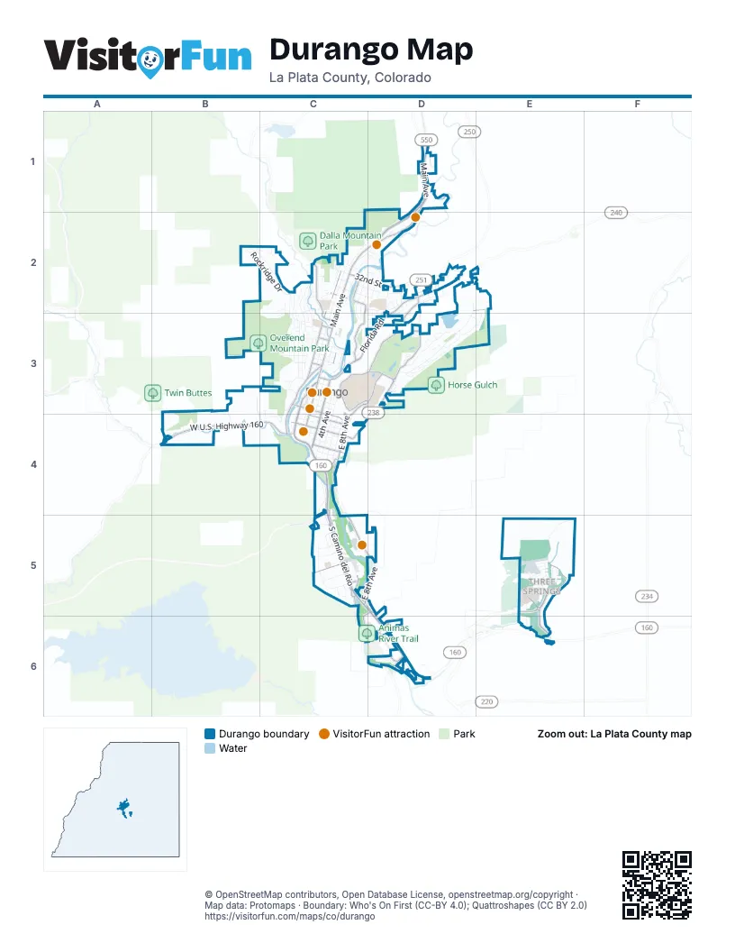
Street index of Durango
Each street on the sheet and the grid squares it crosses.
- South Camino del RioC4, C5, D5, D6
- Main AvenueD1, C2, D2, C3, C4
- Camino del RioC3, C4
- West U.S. Highway 160B4, C4
- North U.S. Highway 550D1
- East 8th AvenueC3, D3, C4, C5, D5
- Florida RoadD2, C3, D3
- Goeglein Gulch RoadD3, C4
- East College DriveC4
- East 32nd StreetC2, D2
- Carbon JunctionC5, D5, D6
- North College DriveD2, D3
- Larry Valdez WayC4
- West College DriveC4
- East 15th StreetC3
- East 3rd AvenueC2, C3, C4
- Rim DriveC3, D3
- Frontage RoadC4, C5
- Animas View DriveD1, D2
- Wilson Gulch DriveE5
- West 3rd AvenueC2, C3
- Three Springs BoulevardE5, E6
- Riverview DriveC2, C3
- Dominquez DriveC5, D5, C6, D6
- Roosa AvenueC3, C4
- Junction StreetC2, C3
- Sawyer DriveC5
- East 8th StreetC4
- East 9th StreetC3, C4
- East 3rd StreetC4
- Fort Lewis DriveD3
- River RoadD6
- Mercury Village DriveC5
- West Park AvenueC3
- Escalante DriveD6
- West 9th StreetC3
- East 29th StreetC2
- La Posta RoadC5
- West 25th StreetC3
- West 24th StreetC3
- West 17th StreetC3
- West 22nd StreetC3
- County Road 213C5
- East Turner DriveC5
- Rim RoadD3
- 29th StreetC2
- Escalante AvenueD6
- County Road 210C4
- West 2nd AvenueC2, D2, C3
- East 2nd AvenueC2, C3, C4
- Jenkins Ranch RoadD2, D3
- East 4th AvenueC2, D2, C3, C4
- East 5th AvenueC2, D2, C3, C4
- East 6th AvenueD2, C4
- Delwood AvenueC2, C3
- Turner DriveC5
- Forest AvenueC3
- Rockridge DriveB2, C2
- Bocea Ranh ParkwayE5
- Sawmill RoadC5, D5
- Talon LaneC3, D3
- Nighthorse CircleE5
- Hillcrest DriveD3
- Crestview DriveC3
- East 7th AvenueD2, C4
- Tanglewood DriveB2, C2
- Arroyo DriveC2, C3
- East 31st StreetC2, D2
- Columbine DriveC2, C3
- East 5th StreetC4
- East 7th StreetC4
- Eastlawn AvenueC3
- Suttle StreetC5
- Confluence AvenueE5
- Tech Center DriveB3, B4, C4
- Narrow Gauge AvenueC3, C4
- Montview ParkwayC3
- Smelter PlaceC4, C5
- East 4th StreetC4
- Cemetery RoadC3
- Prospector AvenueE5
- Rock Point DriveC4
- Rio Vista CircleC2, C3
- Kennebec DriveD3, E3
- Ophir DriveD3
- Metz LaneD2
- River Oaks DriveD6
- Bodo DriveC5
- Leyden StreetC3
- Lizardhead DriveD3
- Avenida del SolC3
- River BendC2, D2
- East 12th StreetC3
- la Questa DriveD3, E3
- Girard StreetC5
- West 4th AvenueC2
- East Twin Buttes TrailB4
- Mesa AvenueD2, C3, D3
- Glenisle AvenueC3
- East 10th StreetC3
- East 11th StreetC3
- Mercado StreetE5
- East 30th StreetC2, D2
- East 2nd StreetC4
- Folsom PlaceC3
- Thomas AvenueC2, C3
- East 9th AvenueC4
- Colorado AvenueD2, D3
- Stewart StreetC5
- Plymouth DriveD2
- Linda CourtD3
- East Animas Village LaneD2
- Holly AvenueD2
- Borrego DriveC2, C3
- Highland AvenueC3
- Primrose CircleE5
- Oxbow CircleE5
- Skyhawk AvenueC3
- Clear Spring AvenueE5
- Kearney StreetC3
- Red Mountain DriveD3
- Oak DriveD2, D3
- Perins Vista DriveB2, C2
- Mears Service RoadD3
- Alamo DriveC3
- East Park AvenueC3
- Burnett DriveC3, B4, C4
- Aspen DriveD2, D3
- Molas DriveD3
- Richard DriveD2
- Bennett StreetC2, D2
- Ferringway CircleD3
- East Owen RoadE6
- Pioneer AvenueE5
- Carol DriveC2
- Animas PlaceC3
- Twin Buttes AvenueB4
- Town PlazaC3
- Ball LaneD2
- Silver Mountain LaneD3
- La Plata PlaceC3
- Parker AvenueC5
- Sanborn PlaceD3
- East 14th StreetC3
- Ella Vita CourtC3
- Weston DriveC3
- Sheppard DriveC5
- West 28th StreetC2
- Rivergate LaneC5
- East 33rd StreetC2, D2
- Coalbank DriveD3
- East 1st StreetC4
- Pinnacle PlaceD3
- Everett StreetC5
- Valentine DriveC3
- Sierra Vista StreetE5
- West 7th StreetC4
- East 36th StreetC2, D2
- Needham DriveC2, C3
- Sage View StreetE5
- Hidden Valley CircleC2, C3
- Silverton AvenueD2
- West 11th StreetC3
- East 18th StreetC3
- West 23rd StreetC3
- Conejo PlaceC2
- Balsam DriveD2
- Bacus AvenueC2
- East 13th StreetC3
- West 31st StreetC2
- West 32nd StreetC2
- San Juan DriveC3
- Lewis Mountain LaneD3
- West 8th StreetC3, C4
- Butte CircleC2
- West 26th StreetC2, C3
- East 37th StreetC2, D2
- East 16th StreetC3
- Westwood PlaceB4
- West 33rd StreetC2
- West 18th StreetC3
- West 19th StreetC3
- West 20th StreetC3
- Alan RoadD2
- West 21st StreetC3
- East 19th StreetC3
- East 20th StreetC3
- Spruce DriveD2
- North Earl StreetD2
- North Hidden Valley CircleC2
- Pine Ridge CourtC2, C3
- Twin Buttes TrailB4
- Cedar AvenueD2
- Virginia StreetC2
- North Glenisle AvenueC3
- Sunridge LaneD2, E2
- Quasar StreetD2
- Arrow Head CircleC2
- Trans Lux DriveC5
- Earl StreetC2
- Falcon WayC3
- 12th StreetC3
- Ford DriveD3
- Cedar Rdg WyD3
- Ryler DriveD3
- Hermosa AvenueC3
- North Bennet StreetD2
- Via VenetoD3
- West 30th StreetC2
- Dedication WayE5
- East Twin ButtesB4
- West 5th AvenueC2
- Burnett CourtC3, C4
- East 21st StreetC3
- Bread ExpressD2
- River Birch StreetE5
- Clovis DriveC2
- Pine Tree WayC2
- Valley View CircleC2
- Baker LaneD6
- Tierra Vista DriveD3
- Villa Escalante CourtD6
- Western AvenueC2
- West 7th AvenueC2
- Via TuscanaD3
- Trestle RoadD6
- Hummingbird LaneD3
- Rivergate PlaceC5
- Jackson PlaceC4
- West 16th StreetC3
- Birket DriveC2
- Tierra Verde DriveD3
- Willow PlaceD3
- Sunburst LaneD2
- Hillside AvenueC2
- East Campus CourtD3
- Recodo del RioD2
- Yarrow CourtE5
- West 29th StreetC2
- West 27th StreetC2
- Salt Brush StreetE5
- West 6th AvenueC2
- Buena Vida AvenueE5
- C. De RinconC2
- O Brien DriveC3, D3
- Butte DriveC2
- West 12th StreetC3
- 35th StreetC2
- Cottonwood DriveC3
- Miller DriveD3
- North Sunburst DriveD2
- Jameson DriveD3
- Maple DriveD2
- Industrial StreetC3
- West Campus CourtC3
- Junction LaneC2
- Nulocun RoadC2
- Delwood PlaceC3
- Depot PlaceC4
- Heritage LaneE5
- Montezuma PlaceC3
- Pleasant DriveC2
- Carriage PlaceC3
- Jenkins DriveD3
- New Mexico AvenueD2, D3
- River Oaks CourtD6
- Sunridge CircleC2
- Hocker DriveC2
- Sunnyside DriveC2
- South Hidden Valley CircleC2, C3
- Sage Hill CourtD2
- Sunshine CourtD2
- South Sunburst LaneD2
- Hilltop CircleD2
- Silverton StreetD2
- Aquarius PlaceD3
- Alamo StreetC3
- Josephine StreetC3
- West 10th StreetC3
- 12th Street PlaceC3
- Osprey WyC3
- South Bennett StreetD2
- Needham CircleC2
- 30th StreetC2
- Elm PlaceD2
- Halto Via CircleC2
- Stuart PlaceC2
- Artisan CourtC2
- Delwood CircleC3
- Oak Valley RidgeD2, E2
- Horse Gulch RoadC4
- Sunburst DriveD2
- West 28th WayC2
- Fiesta CircleD2
- Sunridge CourtD2
- Woodland CircleC2
- West 15th StreetC3
- 17th StreetC3
- Galaxy DriveD2
- Kennebec CourtD3
Things to do on the Durango map
Places on the map
- Adobe Inn
- Adventure Inn Durango
- Albertsons
- Animas Cemetery
- Animas Chocolate Company
- Animas River Trail
- Animas Surgical Hospital
- Aspen Field
- Backcountry Experience
- Bank of the San Juans
- Barefoot Durango
- Baymont By Wyndham Hotel
- Berndt Hall
- Best Western Rio Grande Inn
- Big O Tires
- Buckley Park
- Caboose Motel
- Chapman Hill Recreation Area
- Durango Center
- Durango City Limit
- Durango Mall
- Durango Public Library
- Durango Regulatory Reservoir
- Durango Tech Center
- Folsom Park
- Grabens Loop Trail
- Green Mountain Cemetery
- Hillcrest Golf Club
- Horse Gulch
- Memorial Park
- Mercy Loop
- Mercy Regional Medical Center
- Overend Mountain Park
- Reed Library
- Rim Trail
- Santa Rita - Whitewater Park
- Smith Sports Complex
- Three Springs
- Town Plaza
- Walmart Supercenter
© OpenStreetMap contributors, Open Database License, openstreetmap.org/copyright · Map data: Protomaps · Boundary: Who's On First (CC-BY 4.0); Quattroshapes (CC BY 2.0)















