

Colorado map
Golden map
About 20,151 people live here (Census Bureau, 2024 estimate). The sheet's index lists 300 streets; Golden Freeway, West 44th Avenue and West Colfax Avenue cross the most grid squares. Things to do inside the boundary: Coors Brewery Tour.
Open the map (PDF, US Letter)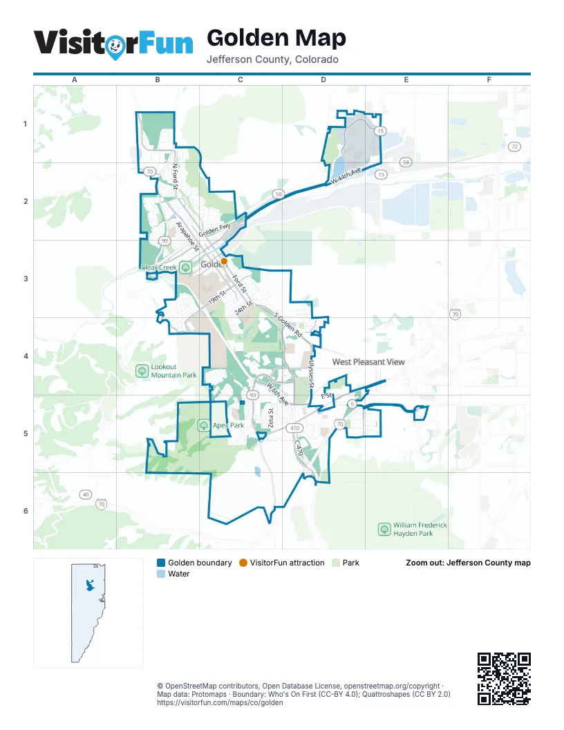
Street index of Golden
Each street on the sheet and the grid squares it crosses.
- Golden FreewayB2, C2, D2, B3
- C-470C5, D5, D6
- West 6th Avenue FreewayD5
- West 6th AvenueC4, C5, D5
- Clear Creek Canyon RoadB3
- West 44th AvenueE1, C2, D2, E2
- Johnson RoadC4, D4, D5
- West Colfax AvenueD4, E4, C5, D5
- South Golden RoadC3, C4, D4
- 19th StreetB3, C3, B4
- Ford StreetB2, C2, C3
- Washington AvenueB2, B3, C3
- Jackson StreetB2, C3
- Jefferson County ParkwayC4, D4
- Heritage RoadC4, C5
- West 6th Avenue Service RoadD5, E5
- 10th StreetC2, B3, C3
- McIntyre StreetE1, E4
- Interplaza WestD5
- Golden Gate Canyon RoadB2
- North Washington AvenueB2
- Indiana StreetE5
- Table Mountain ParkwayD1, E1, D2
- Ulysses StreetD4, D5
- Pine Ridge RoadB1
- North Ford StreetB1, B2, C2
- West 10th AvenueC4, D4
- Lookout Mountain RoadB3, B4
- Iowa DriveB2
- 12th StreetB3, C3
- 8th StreetB3
- 13th StreetB3, C3
- South Rooney RoadD5, D6
- Orchard StreetD5
- Rooney RoadD5
- Moss StreetE4, E5
- Mount Vernon RoadD4
- Easley RoadC2, D2
- Briarwood DriveB3
- Illinois StreetB2, B3, C3, C4
- East StreetB2, C2, C3
- Eagleridge DriveC4, C5
- Arapahoe StreetB2, B3, C3
- Cheyenne StreetB2, B3, C3
- Golden CircleC4, C5
- South Terry StreetD5
- Mount Zion DriveB3, B4
- West 4th AvenueC5, D5, E5
- Ridge RoadB2
- Corporate CircleD5
- Crawford StreetC5
- Canyon Point CircleB2, B3
- 18th StreetC3
- 5th StreetB2, C2, B3
- West 45th DriveD1
- Brickyard CircleB1
- Rimrock DriveC3, D3
- 23rd StreetC3
- West 16th AvenueD4
- 9th StreetC2, B3, C3
- 24th StreetC3
- Table Mountain DriveD1, E1
- West Campus RoadB3, C3
- 14th StreetC3
- Entrada DriveC4, C5
- Lookout View DriveC3
- North Service RoadC2, C3
- Wyoming StreetB1, B2
- Joseph CircleB2
- 22nd StreetC3
- Partridge CircleB2, C2
- 20th StreetC3
- Washington StreetB2
- Utah StreetD3, D4
- White Ash DriveB2
- Foothills RoadB3, B4
- 6th StreetB2, C2, B3
- Zeta StreetC5
- Kimball AvenueC5
- Somerset DriveC4, C5
- Golden Ridge RoadC4, C5
- 16th StreetC3
- Violet StreetD4, D5
- North Rubey DriveB2
- Parfet Estates DriveB3, C3
- South Secrest StreetD5
- E StreetD4, C5
- Maple StreetB3, C3
- Salvia StreetD1, D2, D4
- 17th StreetC3
- Golden Eagle CircleC4, C5
- West 3rd PlaceC5, D5, E5
- Goldco CircleB2
- TelegraphD4, D5
- BisonD4, D5
- CentennialD4, D5
- DeFrance WayC5
- PathfinderD4, D5
- TrapperD4, D5
- North Columbine StreetB2
- Capital DriveD5
- 11th StreetB3, C3
- 21st StreetC3
- Elm StreetB3, C3
- Catamount DriveB1, B2
- Goldenvue DriveB3, B4
- Jesse LaneB1
- West 3rd AvenueC5, D5, E5
- Brickyard RoadB1, B2
- DeFrance DriveC5
- West 1st DriveD5, E5
- Pike StreetD4, D5
- 15th StreetC3
- West 16th PlaceD4
- Crawford CircleC5
- North Jackson StreetB2
- CalvaryD4, D5
- Pinal RoadB3, B4
- PyriteD4, D5
- Crestvue CircleB4
- 1st StreetB2
- Infinity CircleC4
- Mesa DriveB2
- 2nd StreetB2
- Golden Hills RoadD4
- High ParkwayC2
- Prospector's AlleyC3
- Table DriveC3
- Berthoud WayC5
- Garden StreetC2
- Lunnonhaus DriveD4
- Mesa View WayB2
- Poppy StreetD4, D5
- 7th StreetB2, C2, B3
- Cascade DriveB2
- Meadow RunB2
- Sunset DriveC3
- Corporate DriveD5
- Wyoming CircleB1
- West 2nd AvenueD5, E5
- West 5th AvenueD5, E5
- Quaker StreetD1, D5
- West 2nd PlaceD5
- Tangent WayB3, B4, C4
- Orion StreetD5
- Mc Intyre StreetE5
- Moly RoadB3, C3, C4
- Peery ParkwayC2
- Zurich StreetC5
- Lookout View CourtC3
- Chelan StreetC5
- Boyd StreetC2
- Shelton RoadC4
- Mesa Verde StreetC5, D5
- Fawn StreetC5, D5
- Plateau ParkwayC2
- Sage DriveB3
- PioneerD4
- Gregory DriveB2
- West 14th AvenueD4
- Commerce CourtD5
- Pinto StreetD5
- View DriveC5
- Weimer StreetC4
- FrontierD4
- B StreetC5
- C StreetC5
- D StreetC5
- A StreetC5
- Hog Back DriveB1
- F StreetC5
- Rubey DriveB2, B3
- EagleD4
- Sage CircleB3
- Laveta Pass AvenueC5, D5
- Fossil Trace DriveC3, C4
- West 17th PlaceD3
- ComancheD4
- UteD4
- Depot StreetC2
- G StreetC5
- Normans StreetB2, C2
- Pinecone StreetC5, D5
- Newstar WayB2
- Jackson PlaceB2
- High Point DriveB3
- Pine View RoadB1
- Rabbit Run DriveC4
- Allen StreetC5
- Eagle DriveB2
- Jackson DriveB2
- Technology DriveD1
- Marble CircleC5, D5
- Kohinoor PlaceB3
- Smith RoadB3, B4
- Ponderosa CircleC5, D5
- Cressman CourtB2
- Sunshine ParkwayC2
- Belvedere DriveC3
- HomesteadD4
- Iowa StreetB2
- ConestogaD5
- Warner DriveC4
- Commercial RoadD5
- Elm CircleB3
- Blue Jay DriveC4, C5
- Archer StreetC2, C3
- Sagebrush StreetD5
- Miner's Spur RoadB3, C3, B4
- Golden Park PlaceB2
- Zodiac StreetC5
- 4th StreetB2
- Homestake DriveC4
- Vernon DriveC3
- West DriveB2
- ProspectorD4
- Canyon View DriveB3
- SettlerD4
- Castle Rock DriveC3
- Vasquez StreetC2, C3
- Marston TrailC4
- Lou's LoopB1
- West 15th PlaceD4
- Brown Squirrel LaneC4
- Conference PlaceD5
- Deer Springs LaneB2
- Jones RoadC3
- Table Heights DriveC3
- Bonvue DriveB4
- Golden Park DriveB2
- Water StreetC3
- West StreetD5
- Mourning Dove LaneC4
- West 15th AvenueD4
- Peery DriveC2
- Stage CoachD5
- Lilly LaneC2
- Fox Hollow LaneC4
- Mallard StreetD5
- Texas StreetB2
- Alaska StreetB2
- Ptarmigan StreetB2, C2
- Cliff Line RoadB2, C2
- Tucker Gulch DriveB2
- Digger DriveB4, C4
- Virginia StreetB2
- Clear Creek LaneB3
- H StreetC5
- Antero StreetC5
- Idaho StreetB2
- Tripp RoadC5
- 7th PlaceC2
- Valley View CourtB2
- Norse StreetE5
- Dunn RoadC2
- West 7th AvenueD4
- Spyderco WayB2
- Mesa CourtB1, B2
- Crawford DriveC5
- Eagle Nest CourtC5
- Garden Glen CourtB2, C2
- Fossil Trace CourtC4
- Anvil WayC5
- DeFrance CourtC5
- West 9th AvenueD4
- Parkview CourtB3
- StampedeD4
- Rimrock StreetD3
- Snowberry CourtB2
- Cheyenne DriveC3, C4
- Cottonwood CircleC4
- Copper Bucket LaneB2
- Ulysses CourtD4
- 3rd StreetB2
- Miner's AlleyC3
- North Quaker StreetD4
- Willow Creek DriveC3
- Cody TrailB2
- Secrest StreetD4
- Willow CircleC3
- Homestead CircleC5
- Golden Hills PlaceD4
- Butte ParkwayC2
- Easley WayD2
- Utah CourtD4
- West 8th AvenueD4
- Sequoia StreetD5
- Iowa CourtB2
- Clark StreetC2
- Miller PlaceB3
- Tucker Gulch WayB2
- West 8th PlaceD4
- Clearview ParkwayC2
- Meadowlark LaneB2, B3
- Park StreetB2
- Magpie CourtB3
- West 17th DriveD3
- Burgess AvenueC5
- West 12th AvenueD4
- Grand CourtC3
Things to do on the Golden map
Places on the map
- 7-Eleven
- Advance Auto Parts
- American Mountaineering Center
- Apex Park
- Apex Park East Trailhead
- Canyon Point
- City of Golden North Table Mountain Area
- Clear Creek
- Connections Learning Center
- Corporate Center
- Cressman Gulch Park
- Dakota Ridge RV Park
- FedEx Office
- Fossil Trace Golf Club
- Gertrude Bell Middle School
- Golden Bike Park
- Golden Cemetery
- Golden Community Garden
- Golden Heights Park
- Golden High Country Archers
- Golden High School
- Golden Marketplace
- Golden Town Center
- Heritage Square
- Indian Mountain
- InterPlaza
- King Soopers
- Lookout Mountain Youth Services Center
- Mitchell Elementary School
- New Loveland Mine Park
- Rooney Road Sports Complex
- Shelton Elementary
- Sixth Avenue Place
- Specifications Quarry
- Tony Grampas Memorial Sports Complex
- Tucker Gulch
- Ulysses Sports Complex
- Westblade Park
Next to Golden
- West Pleasant View
© OpenStreetMap contributors, Open Database License, openstreetmap.org/copyright · Map data: Protomaps · Boundary: Who's On First (CC-BY 4.0); Quattroshapes (CC BY 2.0)















