

Colorado map
Littleton map
About 44,879 people live here (Census Bureau, 2024 estimate). The sheet's index lists 300 streets; South Prince Street, South Santa Fe Drive and West Mineral Avenue cross the most grid squares. Also on it: Cooley Lake, Horseshoe Park and Littleton Golf Course.
Open the map (PDF, US Letter)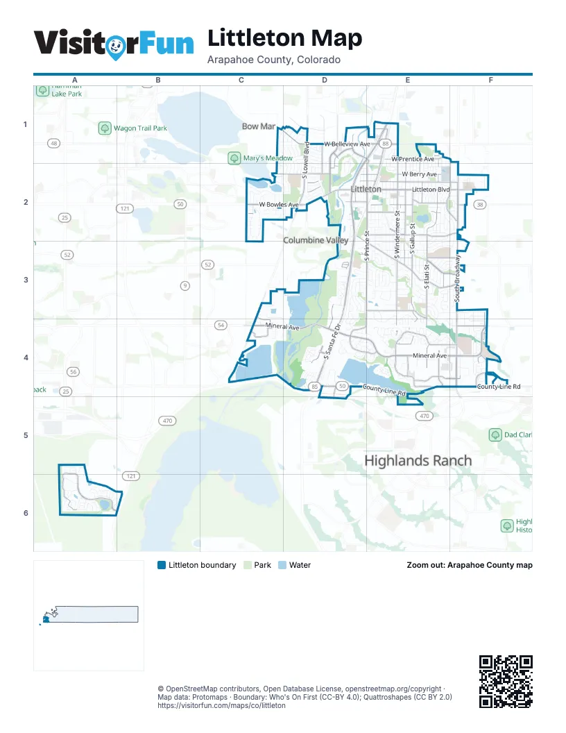
Street index of Littleton
Each street on the sheet and the grid squares it crosses.
- C-470D4, D5
- South Santa Fe DriveD1, E1, D2, D3, D4
- West Mineral AvenueC4, D4, E4, F4
- South BroadwayF2, F3, F4
- West Belleview AvenueC1, D1, E1
- West Bowles AvenueC2, D2
- West Littleton BoulevardE2, F2
- South Federal BoulevardD1, D2
- West Alamo AvenueD2, E2
- West Main StreetD2, E2
- South Rapp StreetD2
- East Arapahoe RoadF3
- Santa Fe DriveD4
- West Ken Caryl AvenueC4
- South Prince StreetD1, E1, E2, E3, D4, E4
- South Windermere StreetE1, E2, E3, E4
- West County Line RoadD4, E4, F4
- East Mineral AvenueF4
- South Lowell BoulevardD1, D2
- South Platte Canyon RoadD2, C3, C4
- East County Line RoadF4
- South Pennsylvania StreetF2, F3, F4
- East Dry Creek RoadF4
- South Pennsylvania DriveF4
- West Mineral DriveC4
- West Jackass Hill RoadD4, E4
- East Orchard RoadF2
- Kendrick Castillo WayE4
- South Elati StreetE1, E2, E3, E4
- West Ridge RoadD2, E3, F3
- South Gallup StreetE2, E3, E4
- West Berry AvenueC2, D2, E2
- South Datura StreetE1, E2, E3, E4
- West Powers AvenueD2, E2, F2
- West Trailmark ParkwayA6, B6
- West Sterne ParkwayE2, E3, F3
- West Caley AvenueE2, F2
- South Bannock StreetF1, E2, F2, E3
- West Shepperd AvenueE2
- South Platte River ParkwayD3, D4
- Southpark LaneE4
- West Prentice AvenueE1, D2
- West Jamison AvenueC4, E4, F4
- South Rio Grande StreetE1, E2
- West Lake AvenueC2, D2, E2
- West Long AvenueD4, E4
- West Euclid AvenueD3, E3, F3
- Southpark DriveE4, F4
- West Centennial DriveD1, D2
- West Geddes AvenueC3, E3, C4
- South Johnson StreetA6
- East Phillips AvenueF4
- Southpark TerraceE4
- South Hickory StreetE1, E2
- South Irving StreetD1, D2
- West Chenango AvenueD1, E1
- South Rangeview DriveE3
- East Littleton BoulevardF2
- West Progress AvenueD1, E1
- Southpark WayE4
- Church AvenueD2, E2
- West Baden DriveA5, A6
- West Phillips AvenueD4
- Erickson BoulevardD4, D5
- Mineral CourtE4
- South Utica DriveC4
- East Broadway CourtF4
- East Panama DriveF2
- South Middlefield RoadD2
- West Lehow AvenueE1
- South Lakeview StreetE1, E2, E3, E4
- South Prescott StreetE1, E2, E3, E4
- South Delaware StreetE1, E2, E3
- West Briarwood AvenueE3
- South Bemis StreetE2, E3, E4
- South Polo Ridge DriveC3, D3, C4, D4
- South Crocker StreetE1, E2, E3
- South Hill StreetE2, E3
- West Dry Creek RoadE4, F4
- South Spotswood StreetE2, E3
- South Cedar StreetE2, E3, E4
- West Peakview AvenueE3, F3
- South Sycamore StreetE2, E3
- Front Range RoadE3
- South Louthan StreetE1, E2, E3, E4
- West Kettle AvenueC4, D4, E4
- South Greenwood StreetE1, E2, E3
- West Crestline AvenueD2, E2
- South Curtice StreetD2, D3, D4
- West Riverwalk CircleD1, D2
- West Davies AvenueD3, E3, F3
- South Logan DriveF4
- South Acoma StreetF2, F3
- South Foresthill StreetE1, E2, E3
- South Huron StreetE1, E2
- West Fair AvenueC2, E2, F2
- South Costilla StreetD3
- South Perry StreetC1, D1, C2
- Blue Sage DriveC2, D2
- South Elmwood StreetE1, E2, E3
- West Jamison CircleE4, F4
- South Fox StreetE1, E2
- South Peninsula DriveE4
- West Aberdeen AvenueC2, D2, E2
- West Maplewood AvenueC2, D2, E2
- West Long DriveD4
- South Cherokee StreetE2, E3
- South Sterne ParkwayE2, E3
- Morning Glory LaneC1, D1, D2
- West Parkhill AvenueE2
- Tule Lake DriveC2, D2
- West Arapahoe RoadE3
- South Nevada StreetD2
- West Long CircleD4
- South Logan StreetF2, F3, F4
- South Julian StreetD1, D2
- West Canal CircleE4
- West Weaver AvenueD2, D3, E3
- Southpark CircleD4
- South Wolhurst DriveD4
- South Coventry Lane WestC2
- West Lake Circle SouthC2, D2
- West Rowland AvenueD3, E3
- South Vinewood StreetD2, D3
- West Dry Creek CourtD4, F4
- West Longview AvenueE2, E3
- South Meade StreetD1
- Shadycroft DriveE3, E4
- South Houstoun Waring CircleD3, D4
- South Sundown CircleE3
- South Coventry Lane EastC2
- South Camargo RoadD1, D2
- South King StreetD2
- East Hinsdale AvenueF3
- East Dry Creek PlaceF3, F4
- West Ida AvenueE2, F2
- West Lake Circle NorthC2, D2
- South Crestview StreetE2, F2
- South Sumner StreetD2
- West Monmouth AvenueD1
- Southpark PlazaE4, F4
- South Bryant StreetD3
- South Windermere CircleE2, E4
- South Grant WayF4
- East Fremont PlaceF3
- South Prince CircleD3, E3
- South Fairfield StreetE2, F2
- South Hill DriveD4, E4
- South Valleyview StreetE2, F2, F3
- West Berry DriveD2, E2
- South Newton StreetD1
- South Cimarron RoadC1, D1, D2
- West Peakview CircleE3
- South Aberdeen StreetE2
- South Linden DriveD1
- South Lincoln StreetF3, F4
- West Jamison PlaceE4
- South Manitou RoadD1, D2
- Shasta CircleC2
- West Dry Creek CircleE3, F3, E4, F4
- South Cedar CircleE3, E4
- West Eden DriveA6
- West Grand AvenueD1
- West Canal CourtE4
- West Easter AvenueE3, E4
- West Valleyview AvenueE3, F3
- West Latonka RoadD1, D2
- West Hinsdale DriveE3, E4
- West Lindenwood DriveE3
- South Field WayA6
- South Mabre CourtD1
- J StreetE4
- West Fremont DriveE3, E4
- West Powers PlaceD2, E2, F2
- South Everett WayA6
- East Nichols DriveF4
- West Arbor AvenueE2
- Aspen LaneD4
- West Caley CircleE2
- West Davies WayE3
- East Powers AvenueF2
- South Westview StreetE2, F2
- Sunset DriveD3, D4, E4
- Bell Flower DriveC2
- South Acoma WayF3
- West Jamison WayD4, E4
- South Crocker WayE1, E3
- South Apache StreetE3
- South Curtice CourtD3, D4
- South Datura CircleE3, E4
- South Mineral PlaceE4
- West Alamo PlaceD2
- West Hillside PlaceC1, D1
- Center DriveD4
- South Johnson WayA6
- Brewery LaneD3
- South Huron WayE1, E2
- West Aspen Grove WayD3
- West Davies Avenue NorthE3, F3
- South Snowberry DriveC2
- West Fremont AvenueE3, F3
- South Clarkson StreetF2
- East Phillips Drive SouthF4
- West Aqueduct AvenueD2
- Bradbury LaneE3
- South Windermere WayE2
- West Finland DriveA6
- South Bannock DriveE3
- South Highland DriveD3
- West Houstoun Waring CircleD3, E3
- South Watson LaneD2
- West Aksarben AvenueD1, D2
- Meadowbrook RoadE3
- West Rafferty Gardens AvenueE1, F1
- West Lilley AvenueE2
- South Prince WayE3
- West Patterson PlaceD2
- South Ogden CircleF4
- South Osceola StreetD1
- West Campus DriveE4
- West Costilla AvenueD3, E3
- West Athens LaneA5
- South Hoyt CourtA5, A6
- West Arlington AvenueD1
- West Cambridge PlaceA6
- South Hill WayE3
- South Platte Reservoir Access RoadC4
- West Elati CircleE4
- South Sherman StreetF2, F3, F4
- West Acoma DriveE3, F3
- West Easter PlaceE3
- West Aberdeen PlaceC2
- South Arapahoe WayE3
- South Flower WayA6
- South Washington StreetF2
- West Caley PlaceE2
- West Caley DriveE2
- West Delaware CircleE3
- Bow Mar DriveC1, C2
- Lowell StreetD4
- South Independence StreetA6
- South Iris CourtA6
- West Danzig PlaceA6
- West Belmont AvenueD1
- Canyon AvenueD4
- West Geddes CircleE3, E4
- South Pennsylvania CourtF4
- South Overlook WayC4
- West Freiburg PlaceA6
- South Buffalo DriveE3, F3
- West Berry PlaceD2, F2
- West Lake PlaceC2, E2
- West Centennial AvenueD1
- South Federal CircleD1, D2
- West Shadycroft LaneE3
- South Buffalo StreetE3
- West Arrowhead RoadD1
- South Keenland CourtD1, D2
- South Davies StreetD3
- West Cannes DriveA6
- Southridge WayE3
- West Crestline DriveE2
- South Jellison WayA5, A6
- West Broadmoor DriveE2, F2
- West Hialeah AvenueD1
- South Zenobia CourtC2
- West Peakview CourtD3, E3
- South Crescent DriveD3
- West Davies PlaceE3
- South Wolff CourtC2
- West Belleview PlaceC1, D1
- South Lupine DriveC2
- South Perry CourtC1, D1
- South Prescott WayE3
- South Longview StreetE2
- Village Park DriveF3
- South Sumac LaneC2
- Graham LaneE3, E4
- South Mohawk RoadD1, D2
- South Lowell WayD2
- Meadowbrook CircleE3
- South Arapahoe DriveE3
- West College DriveD2
- South Platteview DriveC4
- South Gallup CourtE2, E4
- South Apache DriveE3, F3
- West Meadowbrook RoadE3
- West Hinsdale AvenueC4
- South Greens CircleD1
- West Jamison CourtE4, F4
- South Elati CircleE4
- South Holland StreetA6
- South Old Farm RoadC3
- East Nova AvenueF4
- South Grant StreetF2, F4
- West Freiburg DriveA6
- South Ridgeview DriveD3
- South Flower CourtA6
- West Gibraltar PlaceA6
- West Pine Ridge AvenueE3
Places on the map
- AdventHealth Littleton Hospital
- Alamo Drafthouse Cinema
- Angeline Little Greenway
- Ashbaugh Park
- Aspen Grove Shopping Center
- Blackrock Lake
- Bowles Grove Park
- Broadridge
- Carbone Park
- Carmelite Monastery
- Centennial Square
- Columbine Polo Club
- Columbine Valley City Hall
- Cooley Lake
- Coventry Farms
- Denver Seminary
- Eaglewatch Lake
- Encompass Health Rehabilitation Hospital of Littleton
- Euclid Middle School
- Fariview Reservoir
- Gallup Park
- Geneva Park
- Goddard Middle School
- Harlow Park
- Heritage High School
- Highline Professional Center
- Horseshoe Park
- Ivan Thomas Greenbelt
- Ivan Thomas Greenway
- Jackass Hill Park
- Ketring Park
- Littleton Golf Course
- McLellan Reservoir
- Redtail Lake
- South Platte Park
- South Platte Reservoir
- SouthPark
- SouthPark Plaza
- Upper Tule Lake
- Wynetka Ponds Park
Next to Littleton
- Bow Mar
- Columbine Valley
- Highlands Ranch
© OpenStreetMap contributors, Open Database License, openstreetmap.org/copyright · Map data: Protomaps · Boundary: Who's On First (CC-BY 4.0); Quattroshapes (CC BY 2.0)















