

Colorado map
Longmont map
About 99,818 people live here (Census Bureau, 2024 estimate). The sheet's index lists 300 streets; East County Line Road / County Road 1, County Road 1 and Lashley Street cross the most grid squares. Things to do inside the boundary: Longmont Museum.
Open the map (PDF, US Letter)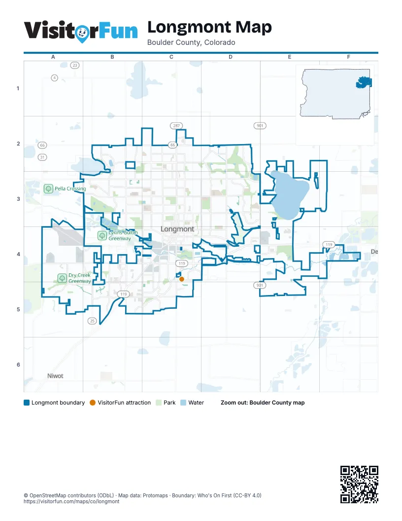
Street index of Longmont
Each street on the sheet and the grid squares it crosses.
- East Ken Pratt BoulevardC4, D4, E4
- Nelson RoadA4, B4, C4
- Main StreetC2, C3, C4
- Hover StreetB2, B3
- East 3rd AvenueC4, D4
- Ute HighwayB2, C2, D2
- South Hover StreetB4, B5
- East County Line Road / County Road 1D3, E3, D4, D5
- Ken Pratt BoulevardB4, C4, B5
- 3rd AvenueB4, C4, D4
- South Main StreetC4, C5
- Diagonal HighwayB5
- Tenacity DriveC5
- East County Line RoadD3, D4
- County Road 1D3, E3, D4, E4
- 17th AvenueB3, C3
- South Pratt ParkwayC4, C5
- 9th AvenueB3, C3
- Pike RoadA5, B5, C5
- Pace StreetD2, D3, D4
- Francis StreetC2, C3, C4
- East 17th AvenueC3, D3, E3
- Lashley StreetC2, C3, D3, D4
- Airport RoadB2, B3, B4
- North 75th StreetA4, A5
- East 9th AvenueC3, D3
- South Sunset StreetC4, C5
- Sunset StreetB3, C3, C4
- Martin StreetC3, C4, D4
- South Airport RoadB4, B5
- South Martin StreetC4, D4
- 2nd AvenueC4
- 21st AvenueB2, C2
- Mountain View AvenueB3, C3, D3
- Clover Basin DriveB4, A5, B5
- Alpine StreetD2, D3, D4
- Gay StreetC2, C3, C4
- Collyer StreetC2, C3, C4
- Emery StreetC2, C3, C4
- 15th AvenueB3, C3
- Longs Peak AvenueB3, C3
- Deerwood DriveD3
- 11th AvenueB3, C3
- Kimbark StreetC2, C3, C4
- Pratt StreetC2, C3, C4
- Boston AvenueB4, C4
- Terry StreetC2, C3, C4
- Spencer StreetB2, B3
- Sundance DriveD2, D3
- Dry Creek DriveB4, B5
- Harvard StreetB2, B3
- South Fordham StreetB4, B5
- 23rd AvenueB2, C2
- Coffman StreetC3, C4
- Olympia AvenueC2, D2
- 19th AvenueC2
- South Bowen StreetC4, C5
- Plateau RoadB5, C5
- East 5th AvenueC4, D4
- 1st AvenueC4
- East Mountain View AvenueD3
- South Emery StreetC4, C5
- Zlaten DriveD4, E4
- 4th AvenueC4
- 5th AvenueC4
- Quail RoadB4, C4
- Missouri AvenueC4, C5
- Quebec AvenueC5
- North Shore DriveB2
- Northwestern RoadB3
- South Sherman StreetC4, C5
- Fordham StreetB3
- Rogers RoadA4, B4
- Lefthand DriveC4, C5
- Creekside DriveB5, C5
- Price RoadC4
- Bent WayB4
- County Road 20 1/2E5
- South Francis StreetC4, C5
- Junction DriveC4
- Grandview Meadow DriveA4, A5
- Kansas AvenueC4
- Horizon ParkwayB2
- Saint Vrain RoadA3, A4, B4
- North 119th StreetD4
- Emerald DriveC5
- East 21st AvenueC2, D2
- Thayer AvenueD4
- Fox Hill Country ClubD4
- Colorado AvenueC4
- Park Ridge AvenueC2
- Erfert StreetC2
- North 95th StreetB2
- Ludlow StreetD4
- Turquoise DriveC5
- Harvest Moon DriveD4
- North 105th StreetC5
- Atwood StreetC2, C3, C4
- Lincoln StreetC2, C3, C4
- County Road 28E2, E3, F3
- Bowen StreetC2, C3, C4
- County Road 26D3, E3, F3
- Grant StreetC2, C3, C4
- Sumner StreetC2, C3, C4
- Vivian StreetC2, C3, C4
- South Coffman StreetC4, C5
- 6th AvenueC3
- Bross StreetC3, C4
- Judson StreetC2, C3, C4
- Tulip StreetB2, B3
- 10th AvenueB3, C3
- Baker StreetC3, C4
- Whitehall DriveD3
- Cedarwood DriveD3
- East 4th AvenueC4, D4
- East Rogers RoadC4, D4
- 12th AvenueB3, C3
- 14th AvenueB3, C3
- Mountain DriveA4, A5
- Sherman StreetC2, C3, C4
- 8th AvenueC3
- Renaissance DriveA5, B5
- Fox Hill DriveD3, D4
- Bella Vista DriveA5
- Twin Peaks CircleB3
- South Terry StreetC4, C5
- Western Sky CircleC4
- Glenarbor CircleD2
- 16th AvenueB3, C3
- 24th AvenueB2, C2
- Great Western DriveD4
- Linden StreetB2, B3
- Purdue DriveB3
- 18th AvenueB3, C3
- Meadow StreetC2, C3
- Sugar Mill RoadD4
- East Longs Peak AvenueC3, D3
- Corey StreetC2, C3
- Stuart StreetB2, B3
- Lakeshore DriveB3
- Sumac StreetB2, B3
- Tyrrhenian CircleD2
- Winding DriveC2, D2
- Columbia DriveB3
- Clover Creek DriveB5
- Lake Park WayB2
- Spruce AvenueB4, C4
- Button Rock DriveD3
- Elliott StreetD3, D4
- Heather Hill CircleA5, B5
- Red Mountain DriveD3
- Neon Forest CircleC5
- Baylor DriveB3
- Santa Fe DriveD2
- Venice StreetC3
- Larkspur DriveB5
- Armstrong DriveD3, E3
- Juniper StreetC2, C3
- Red Cloud RoadC2, C3, D3
- Frontier StreetB2, B3
- Sherri Mar StreetB2, B3
- Red Oak DriveD3
- Ute Creek DriveD2, D3
- Eagleview CircleB5
- Cambridge DriveB2, B3
- Weaver Park RoadD4
- Sunset DriveB2
- Iowa AvenueC4
- Sunlight DriveC2, D2, D3
- Duchess DriveC3
- Whistler DriveC2, D2
- Yeager DriveC2, C3
- High Point DriveD4
- Monarch DriveD3
- Grand AvenueC4
- Summer Hawk DriveD3, D4
- Warren AvenueB3, C3
- 22nd AvenueB2, C2
- North Parkside DriveC5
- Rider Ridge DriveD3, D4
- Delaware AvenueC4
- Onyx CircleC5
- Lefthand CircleB5, C5
- Fall River CircleD3
- Stardance CircleD3, D4
- Princeton DriveB3
- East Saint Clair AvenueC3, D3
- Centennial DriveC3
- Mount Evans DriveD3
- Independence DriveD3
- Lamplighter DriveC3
- Disc DriveA4
- Falcon DriveB2
- Hilltop DriveD3
- Oakwood DriveB4
- Judson DriveB3, C3
- Prairie Fire CircleA4, B4
- Homestead ParkwayC2, D2
- Trade Centre AvenueB4
- Sugar Beet CircleC4
- Canadian Crossing DriveC2, D2
- Mount Evans StreetD3, D4
- Turin DriveA5
- Wyndemere CircleD2
- Martin RoadC3, D3
- Cornell DriveB3
- Kay StreetB2, B3
- Lake Park DriveB2
- Wildrose DriveB5
- Summerlin LaneA5
- Winslow CircleD3, D4
- Kylie DriveD4
- Summitview DriveC5
- Harlequin DriveD3
- Aspen StreetC3
- South Kimbark StreetC4, C5
- Eagan CircleA5
- Calais DriveD2
- Trail Ridge RoadD3
- Corporate Center CircleB5
- Tyrrhenian DriveD2
- Dorothy CircleA5
- Parker DriveC2
- Peppler DriveC2, D2
- Ridgeview DriveC5
- Wade RoadB3, B4
- Da Vinci DriveA4, B4, B5
- Florentine DriveA4, A5, B5
- Beech CircleB2
- Tempted Ways DriveC5
- Ponderosa CircleD3
- Steppe DriveC2, D2
- East 15th AvenueC3, D3
- Hawthorne CircleA4, B4
- GPE GreenwayB3, B4
- Hackberry CircleB2
- Cedar Pine DriveD3
- Danbury DriveB3
- Portofino DriveA5
- Bountiful AvenueC4, D4
- Redmond DriveA4
- Schlagel RoadB4
- Brookfield DriveC5
- Clarendon DriveD3
- Flemming DriveC2
- Iron Horse DriveD4
- Meeker StreetD3
- Westlake DriveB2
- San Marco DriveA5
- Meeker DriveD3
- Saint Andrews DriveD3
- Staghorn DriveA4, B4
- Belmont DriveB3
- Goshawk DriveD3
- Provenance StreetD2
- Lochmore DriveD2, D3
- Stonebridge DriveB4
- Jewel StreetC2
- Wedgewood AvenueB3
- Highland DriveD3
- Brookside DriveD3
- Hudson PlaceD4
- Kane DriveC4
- Mumford AvenueC2
- Drake StreetB3
- Copper Peak LaneC2
- Lanyon DriveB3
- Buchanan LaneD3
- Venice LaneB5
- Blue Mountain CircleA4, A5
- Amethyst DriveC5
- Sunrise DriveC2
- Trout Creek CircleD3
- East 1st AvenueC4, D4
- Kensington StreetC3, C4
- Antero DriveC3
- Preston DriveD3
- Spotswood StreetD2
- Hilltop StreetD3
- Pintail DriveB5
- Charles DriveB3
- Steele StreetB2
- Denison CircleB3
- Holly AvenueC4, C5
- Reserve DriveD3
- Elmhurst DriveB3
- Mount Sneffels StreetC2, C3
- South Gay DriveC4
- Bluegrass DriveB4
- Kubat LaneA4
- Miller DriveB5
- Nelson Park DriveB4
- Cannon Mountain DriveA5
- Lucca DriveA5
- Queens DriveC2, C3
- Twin Sisters DriveD3
- Four Leaf DriveA4
- Windflower DriveD3
- Widgeon DriveB3, B4
- Americana RoadD3
Things to do on the Longmont map
Places on the map
- Affolter Park
- Blue Skies Park
- Calkins Reservoir
- Clark Centennial Park
- Clover Basin Trail
- Colorado Materials
- Dawson Park
- Dickens Farm Nature Area
- Dry Creek Greenway
- Express It
- Fall River Elementary School
- FedEx Office
- Fox Creek village
- Garden Acres Sports Park
- Golden Ponds
- Harvest Junction North & South
- Horizon Park Shopping Center
- Hover Acres Park
- Izaak Walton Park
- Jim Hamm Nature Area
- Kanemoto Park
- Kensington Park
- Lanyon Park
- Left Hand Creek Park
- Longmont Clinic
- Longmont Downtown
- Longmont Estates Elementary
- Longmont High School
- Longmont Medical Campus
- Longs Peak Hospital
- Parkway Promenade
- Saint Vrain Greenway
- Sandstone Ranch Community Park
- Sunset Golf Course
- Twin Peaks Golf Course
- Union Reservoir
- Ute Creek Golf Course
- Village at the Peaks
- Walmart Supercenter Longmont
- Western Meadows
Next to Longmont
- Mead
- Niwot
© OpenStreetMap contributors, Open Database License, openstreetmap.org/copyright · Map data: Protomaps · Boundary: Who's On First (CC-BY 4.0); Quattroshapes (CC BY 2.0)