

Colorado map
Superior map
About 13,654 people live here (Census Bureau, 2024 estimate). The sheet's index lists 251 streets; McCaslin Boulevard, Rock Creek Parkway and South Indiana Street cross the most grid squares. Also on it: Coyote Ridge Open Space, Autrey Park and Superior Marketplace.
Open the map (PDF, US Letter)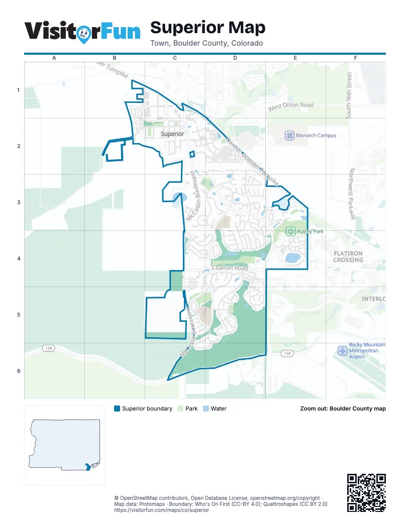
Street index of Superior
Each street on the sheet and the grid squares it crosses.
- Blackfoot StreetB1
- Cherokee AvenueB1
- Fox LaneB1
- Marshall DriveB1
- Marshall RoadB1, C1, C2
- Shawnee LaneB1
- South 76th StreetB1, B2
- Sycamore CircleB1, B2
- 5th AvenueC1, C2
- Center DriveC1
- Denver–Boulder TurnpikeC1, D2, E3
- McCaslin BoulevardC1, C2, C3, C4, C5, C6
- South McCaslin BoulevardC1
- Superior Plaza WayC1, C2
- Sycamore StreetC1, B2, C2
- Cayauge WayB2
- Charles StreetB2, C2
- Coal Creek DriveB2, D2, D3
- Mohawk CircleB2
- West Coal Creek DriveB2, C2
- 1st AvenueC2
- 2nd AvenueC2
- 3rd AvenueC2
- 4th AvenueC2
- Creek View WayC2, D2
- Depot StreetC2
- Discovery ParkwayC2, D2
- East Coal Creek DriveC2
- East Douglas StreetC2
- East William StreetC2
- Eighth AvenueC2
- Main StreetC2, D2
- Old Rail WayC2, D2
- Park PlaceC2
- Sixth AvenueC2
- South 3rd AvenueC2
- South Brandon CourtC2, D2
- South Marshall RoadC2
- West Charles StreetC2
- West Douglas StreetC2
- West Maple StreetC2
- West Thomas StreetC2
- West William StreetC2
- Anticline LaneD2
- Avena LaneD2
- Blue Grama LaneD2
- Blue Stem LaneD2
- Cannel LaneD2
- Central Park CircleD2
- Central Park WayD2
- Crosspole LaneD2
- East Karval PlaceD2
- East Wiggins StreetD2, D3
- Feathergrass LaneD2
- Fescue LaneD2
- Fountain LaneD2
- Frontier LaneD2
- Incline LaneD2
- Josephine WayD2
- Junegrass LaneD2
- Junegress LaneD2
- Kite Route LaneD2
- Lanterns LaneD2, D3
- Lodgepole LaneD2
- Meridian CourtD2
- Meridian LaneD2
- Miner LaneD2
- Paintbrush LaneD2
- Pioneer LaneD2
- Promenade DriveD2, D3, E3
- Promenade LaneD2
- Ridgepole LaneD2
- Settler LaneD2
- South Pitkin AvenueD2, D3
- South Wiley CourtD2
- Superior Cemetery access roadD2
- Superior DriveD2
- Switch Grass LaneD2
- Trail LaneD2
- Village Green WayD2
- Campo WayC3, D3
- East Gill WayC3, D3
- Edison PlaceC3
- Eldorado CircleC3, D3
- High Plains CourtC3
- High Plains DriveC3
- Masters CourtC3, D3
- Rock Creek ParkwayC3, D3, E3, D4, E4
- Rockview CircleC3
- Rockview DriveC3
- Alma LaneD3
- Amherst StreetD3
- Amherst WayD3
- Breen LaneD3, D4
- Cedaridge CircleD3, D4
- Dillon WayD3
- East Akron PlaceD3
- East Heartstrong StreetD3
- East Iliff WayD3
- East Kirk WayD3
- East Riverbend StreetD3
- East Riverbend WayD3
- East Roggen WayD3
- East Weldona WayD3, E3
- Eldorado DriveD3, D4
- Estabrook WayD3, E3, E4
- Keota LaneD3, D4
- Rand WayD3
- Raymer LaneD3
- Snyder WayD3
- South 88th StreetD3, E3
- South Boyero CourtD3
- South Elbert CourtD3
- South Elmore CourtD3
- South Gibson CourtD3
- South Hillrose LaneD3
- South Idalia CourtD3
- South Indiana StreetD3, D4, C5, D5
- South Laird CourtD3
- South Mesa CourtD3
- South Montgomery CourtD3
- South Proctor CourtD3
- South Riverbend CourtD3
- South Riverbend LaneD3
- South Seibert CourtD3
- South Union CourtD3
- South Vilas CourtD3
- South Vona CourtD3
- South Weldona LaneD3
- Stoneham StreetD3
- Vernon LaneD3
- Concord LaneE3
- Eagle AvenueE3
- Egret WayE3
- Enterprise StreetE3
- Eureka LaneE3
- Harris StreetE3
- Honey Creek LaneE3, E4
- Mallard DriveE3
- Morrison CourtE3
- Oxford LaneE3
- Piper StreetE3
- Reliance CircleE3
- Reliance CourtE3
- Shamrock DriveE3
- Spaulding CircleE3
- Ajax CourtC4
- Alpha CourtC4
- Andrew DriveC4, D4
- Andrew LaneC4
- Antero PlaceC4
- Bella PlaceC4, C5
- Briggs PlaceC4, D4
- Bristol StreetC4, D4
- Calmante AvenueC4, C5
- Calmante CircleC4
- Calmante PlaceC4
- Casalon CircleC4, C5
- Casalon PlaceC4
- Christenson AvenueC4
- Coalton RoadC4, D4, E4
- Dailey LaneC4
- Dailey StreetC4, D4
- Eaton CircleC4, D4
- Emerson LaneC4, D4
- Erie LaneC4
- Tierra Ridge CourtC4, D4, C5
- Basil PlaceD4, D5
- Castle Peak AvenueD4, D5
- Christy WayD4
- Clayton CircleD4
- Coal Ridge DriveD4, E4
- Denslow LaneD4
- East Shadow LaneD4
- East Yarrow CircleD4, D5
- Firestone WayD4, E4
- Flagstone PlaceD4
- Flint CourtD4
- Gold WayD4
- Grayden CourtD4
- Holyoke LaneD4
- Imperial LaneD4
- Imperial WayD4
- Jade CourtD4, D5
- Jarosa LaneD4
- Lasalle StreetD4
- Limestone PlaceD4
- Marble LaneD4, D5
- Monarch WayD4
- Monroe WayD4
- North Summit CircleD4
- North Torreys Peak DriveD4, D5
- Northern WayD4
- Platinum CourtD4
- Quartz WayD4
- Rock Creek CircleD4
- Silver PlaceD4
- Slate CourtD4
- South Summit CircleD4
- Topaz StreetD4
- West Yarrow CircleD4, D5
- West Yarrow DriveD4
- Autrey DriveE4
- Connor WayE4
- Lakeshore LaneE4
- South Tyler DriveE4
- Amethyst WayC5
- Jasper WayC5
- North Snowmass CircleC5, D5, C6
- Onyx WayC5
- Opal LaneC5
- Opal WayC5
- Pyramid CourtC5, D5, D6
- West Torreys Peak DriveC5, D5
- Zircon WayC5, D5
- Animas WayD5
- Aster CourtD5
- Basalt CourtD5
- Begonia WayD5
- Blanca Peak CourtD5
- Blanca Peak DriveD5
- Canna PlaceD5
- Cimarron PlaceD5
- Cobalt WayD5
- Coneflower CourtD5
- Gardenia WayD5
- Goldeneye PlaceD5
- Graphite WayD5
- Grays Peak DriveD5
- Gypsum CourtD5
- Humboldt WayD5
- Huron Peak AvenueD5
- Huron Peak PlaceD5
- Hyacinth WayD5
- Ivy PlaceD5
- Mica CourtD5
- Mount Sopris ParkwayD5
- Ruby WayD5
- Sandstone WayD5
- Sapphire WayD5
- Shale CourtD5
- Shavano Peak DriveD5
- Snap Dragon CourtD5
- South Snowmass CircleD5, C6, D6
- South Torreys Peak DriveD5
- Sunlight WayD5
- Vinca PlaceD5
- Windom Peak DriveD5
- North Indiana StreetC6
- Ridge ParkwayD6
- Skyview LaneD6
Places on the map
- Asian Cuisine
- Autrey Park
- Autrey Park Disc Golf Course
- Autrey Park Dog Park
- Autrey Pickleball Court
- Autrey Reservoir
- Blue Federal Credit Union
- Boss Lady Pizza
- Brakes Plus
- Chuck E. Cheese
- Community garden
- Community Park
- Costco
- Coyote Ridge Open Space
- Coyote Ridge Trailhead
- Eldorado K-8 School
- Flow Track
- Founders Park
- Great Clips
- IHOP
- Michaels
- Mountain View Fire Rescue Station 5
- My Kid's Dentist
- Oerman-Roche Trailhead
- Panera Bread
- PetSmart
- Phillips 66
- Purple Park
- RH Outlet
- Rock Creek Wine & Spirits
- Safeway
- Safeway Fuel Station
- Scanlan
- Sport Stable
- Stewart
- Sup Town CrossFit
- Superior Marketplace
- Superior Town Hall
- The UPS Store
- Wildflower Park
Next to Superior
- Flatiron Crossing
- Interlocken
© OpenStreetMap contributors, Open Database License, openstreetmap.org/copyright · Map data: Protomaps · Boundary: Who's On First (CC-BY 4.0); Quattroshapes (CC BY 2.0)















