

Colorado map
Wheat Ridge map
About 31,999 people live here (Census Bureau, 2024 estimate). The sheet's index lists 217 streets; West 44th Avenue, West 42nd Avenue and West 46th Avenue cross the most grid squares. Also on it: Applewood Village, Former Lutheran Medical Center Campus and Lutheran Medical Center.
Open the map (PDF, US Letter)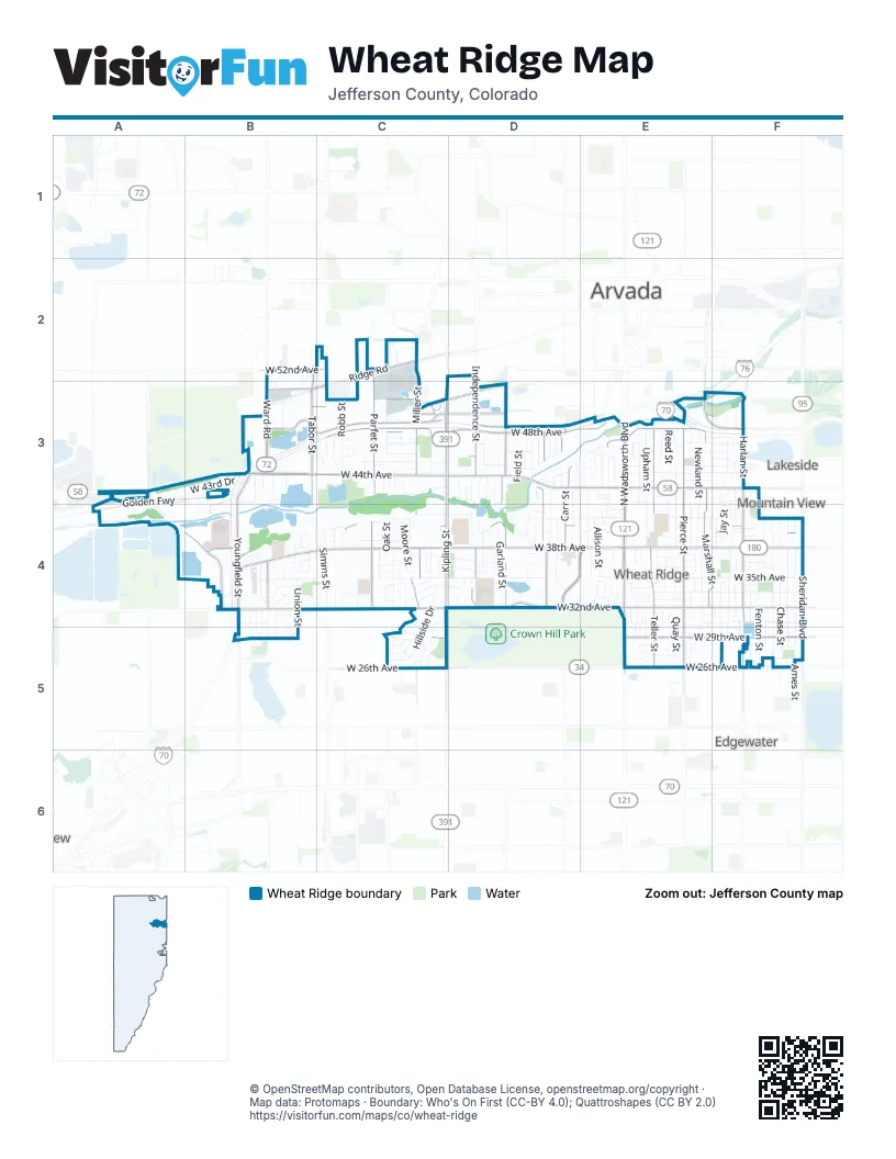
Street index of Wheat Ridge
Each street on the sheet and the grid squares it crosses.
- Tabor StreetB2, B3, B4
- Taft CourtB2, B3, B4
- Union CourtB2, B4
- Vivian StreetB2, B3, B4, B5
- West 52nd AvenueB2, C2
- Miller StreetC2, C3, C4, C5
- Nelson StreetC2, C3, C4, C5
- Newcombe StreetC2, C3, C5
- Oak StreetC2, C3, C4, C5
- Parfet StreetC2, C3, C4
- Pierson CourtC2, C4
- Quail StreetC2, C3, C4
- Ridge RoadC2, B3, C3
- Simms PlaceC2, C3
- Swadley StreetC2, C3, B4, C4
- West 53rd AvenueC2
- West 54th AvenueC2
- Iris StreetD2, D3
- Jellison CourtD2, D4
- Jellison StreetD2, D3, D4
- Johnson StreetD2, D4
- West 51st AvenueD2, B3, D3
- West 51st PlaceD2
- Eldridge StreetA3
- Golden FreewayA3, B3, A4
- West 43rd DriveA3, B3
- West 44th AvenueA3, B3, C3, D3, E3, F3
- Van Gordon StreetB3
- Ward RoadB3, B4
- West 42nd AvenueB3, D3, E3, F3, D4, E4
- West 46th AvenueB3, C3, D3, E3, F3
- West 49th AvenueB3, C3, D3, E3, F3
- West 49th PlaceB3, D3, F3
- West I-70 Frontage Road NorthB3, C3, D3
- Wright StreetB3, B4, B5
- Xenon StreetB3, B4
- Youngfield StreetB3, B4, B5
- Kipling StreetC3, C4, C5
- Knowlan StreetC3
- Lee StreetC3, C4
- Moore CourtC3, C4
- Moore StreetC3, C4, C5
- Owens StreetC3, C4
- Pierson StreetC3, C4
- Queen CourtC3
- Robb StreetC3, C4
- Routt StreetC3, C4
- Simms CourtC3, C4
- Simms StreetC3, C4
- West 43rd AvenueC3, D3, E3, F3
- West 44th PlaceC3, D3, E3, F3
- West 45th AvenueC3, D3, E3, F3
- West 45th PlaceC3, D3, E3, F3
- West 46th PlaceC3, D3, E3, F3
- West 47th AvenueC3, D3, E3, F3
- West 47th PlaceC3, E3, F3
- West 48th AvenueC3, D3, E3, F3
- West 50th AvenueC3, D3, F3
- West I-70 Frontage Road SouthC3, D3
- Brentwood StreetD3, D4
- Carr StreetD3, D4
- Cody StreetD3, D4
- Dover StreetD3, D4
- Dudley StreetD3, D4
- Estes StreetD3, D4
- Everett CourtD3
- Everett DriveD3, D4
- Everett StreetD3, D4
- Field CourtD3
- Field StreetD3, D4
- Flower StreetD3, D4
- Garland StreetD3, D4
- Garrison StreetD3, D4
- Holland StreetD3, D4
- Hoyt CourtD3, D4
- Hoyt StreetD3, D4
- Independence StreetD3, D4
- Iris CourtD3, D4
- North I-70 Service RoadD3, E3
- West 50th LaneD3
- Allison StreetE3, E4
- Ammons StreetE3, E4
- Balsam StreetE3, D4, E4
- Heartland ExpresswayE3, F3
- Marshall StreetE3, F3, E4, F4
- Newland StreetE3, E4, E5
- North Wadsworth BoulevardE3, E4, E5
- Otis StreetE3, E4
- Pierce StreetE3, E4, E5
- Quay StreetE3, E4, E5
- Reed StreetE3, E4, E5
- Saulsbury StreetE3, E4, E5
- Teller StreetE3, E4, E5
- Upham StreetE3, E4, E5
- Vance StreetE3, E4, E5
- Webster StreetE3, E4, E5
- West 43rd CircleE3
- West 43rd PlaceE3
- West 46th CircleE3
- West 48th CircleE3
- West 49th DriveE3, F3
- Yarrow CourtE3, E4
- Yarrow StreetE3, E4
- Yukon CourtE3, E4
- Zephyr StreetE3, E4
- Fenton StreetF3, F4, F5
- Gray StreetF3, F4, F5
- Harlan CourtF3
- Harlan StreetF3, F4, F5
- Ingalls CourtF3, F4
- Ingalls StreetF3, F4, F5
- Jay StreetF3, F4
- Kendall StreetF3, F4, F5
- Lakeside LaneF3
- Lamar StreetF3, E4, F4, F5
- West 48th PlaceF3
- Clear Creek DriveA4, B4
- Frontage RoadA4
- Mountain Shadow DriveB4, B5
- Tabor CourtB4
- Tabor DriveB4
- Union StreetB4, B5
- Urban CourtB4
- Urban StreetB4
- Vivian CourtB4
- Vivian DriveB4
- Ward CourtB4, B5
- West 31st AvenueB4, C4, E4, F4
- West 31st PlaceB4, E4
- West 32nd AvenueB4, C4, D4, E4, F4
- West 32nd DriveB4
- West 32nd PlaceB4, C4, D4, E4
- West 33rd AvenueB4, C4, D4, E4, F4
- West 33rd PlaceB4, C4
- West 34th AvenueB4, C4, D4, E4, F4
- West 34th PlaceB4, C4, E4
- West 35th AvenueB4, C4, D4, E4, F4
- West 36th AvenueB4, C4, D4, E4, F4
- West 36th PlaceB4, C4, E4, F4
- West 37th AvenueB4, C4, D4, E4, F4
- West 37th PlaceB4, C4, D4, E4, F4
- West 38th AvenueB4, C4, D4, E4, F4
- West 38th DriveB4
- West 38th PlaceB4, C4, D4, E4
- West 39th CircleB4, C4
- West 39th PlaceB4, C4, F4
- West 40th AvenueB4, C4, D4, F4
- West 40th CircleB4, C4
- Wright CourtB4, B5
- Youngfield Service RoadB4
- Hillside DriveC4, C5
- Kline StreetC4
- Lewis StreetC4
- Miller CourtC4
- Miller WayC4
- Morningside DriveC4, C5
- Newman StreetC4
- Ohayre CourtC4
- Owens CourtC4
- Quail CourtC4
- Rangeview DriveC4, C5
- Robb CircleC4
- Rolfe CourtC4
- Skyline DriveC4, C5
- West 34th DriveC4, D4, E4
- West 35th PlaceC4, E4, F4
- West 39th AvenueC4, D4, E4, F4
- West 41st AvenueC4, D4, E4, F4
- West 41st PlaceC4
- Cody CourtD4
- Field DriveD4
- Holland CourtD4
- Independence CourtD4
- Lutheran ParkwayD4, E4
- Lutheran Parkway WestD4
- 36th AvenueE4
- Allison CircleE4
- Allison CourtE4
- Ammons CourtE4
- High CourtE4
- Marshall CourtE4, E5
- Melrose DriveE4
- Saulsbury CourtE4
- Three Acre LaneE4
- Upham CourtE4
- West 30th AvenueE4, F4, C5
- Zephyr CourtE4
- Zephyr DriveE4
- Ames StreetF4, F5
- Benton StreetF4, F5
- Chase StreetF4, F5
- Depew StreetF4, F5
- Eaton StreetF4, F5
- Fenton CourtF4
- Sheridan BoulevardF4, F5
- West Moncrieff PlaceF4
- Simms DriveB5
- Swadley DriveB5
- West 29th PlaceB5, E5, F5
- West 30th PlaceB5
- Circle DriveC5
- Dawn CourtC5
- Paramount ParkwayC5
- Rangeview CircleC5
- Rangeview PlaceC5
- Twilight DriveC5
- West 26th AvenueC5, E5, F5
- West 27th AvenueC5, E5, F5
- West 29th AvenueC5, E5, F5
- Newland CourtE5
- Otis CourtE5
- Reed CourtE5
- Teller CourtE5
- Wadsworth BoulevardE5
- West 26th PlaceE5
- West 28th AvenueE5, F5
- West 28th PlaceE5
Places on the map
- 5280 Gymnastics
- Abra Auto Body Repair
- Abundant Grace Fellowship Church
- Affordable Inns
- Anderson Park
- Applewood
- Applewood Village
- Arvada Fire Protection District Station 2;Arvada Fire Protection District Station 52
- Ashland Reservoir
- Associates
- Bass Lake
- Best Interstate Inn
- Beth Eden Baptist Church
- Brass Armadillo
- Burger King
- Chick-fil-A
- CreekSide Park
- Everitt Middle School
- Fairmount Park
- Former Lutheran Medical Center Campus
- Johnson Park
- Kullerstrand Elementary School
- Lewis Meadows Park
- Lutheran Medical Center
- Medved
- North Henry Lee Reservoir
- Paramount Park
- Prospect Lake
- Prospect Park
- Stevens Elementary School
- Tabor Lake
- The UPS Store
- West Lake
- Wheat Ridge High School
- Wheat Ridge Library
- Wheat Ridge Post Office
Next to Wheat Ridge
- Arvada map
- Edgewater
- Lakeside
- Mountain View
© OpenStreetMap contributors, Open Database License, openstreetmap.org/copyright · Map data: Protomaps · Boundary: Who's On First (CC-BY 4.0); Quattroshapes (CC BY 2.0)















