

Florida map
Jacksonville map
About 1,009,833 people live here (Census Bureau, 2024 estimate). The sheet's index lists 18 streets; West Beltway, East Beltway and Martin Luther King Jr. Parkway cross the most grid squares. Also on it: Alderman Park, Amelia View and Anheuser-Busch Brewery.
Open the map (PDF, US Letter)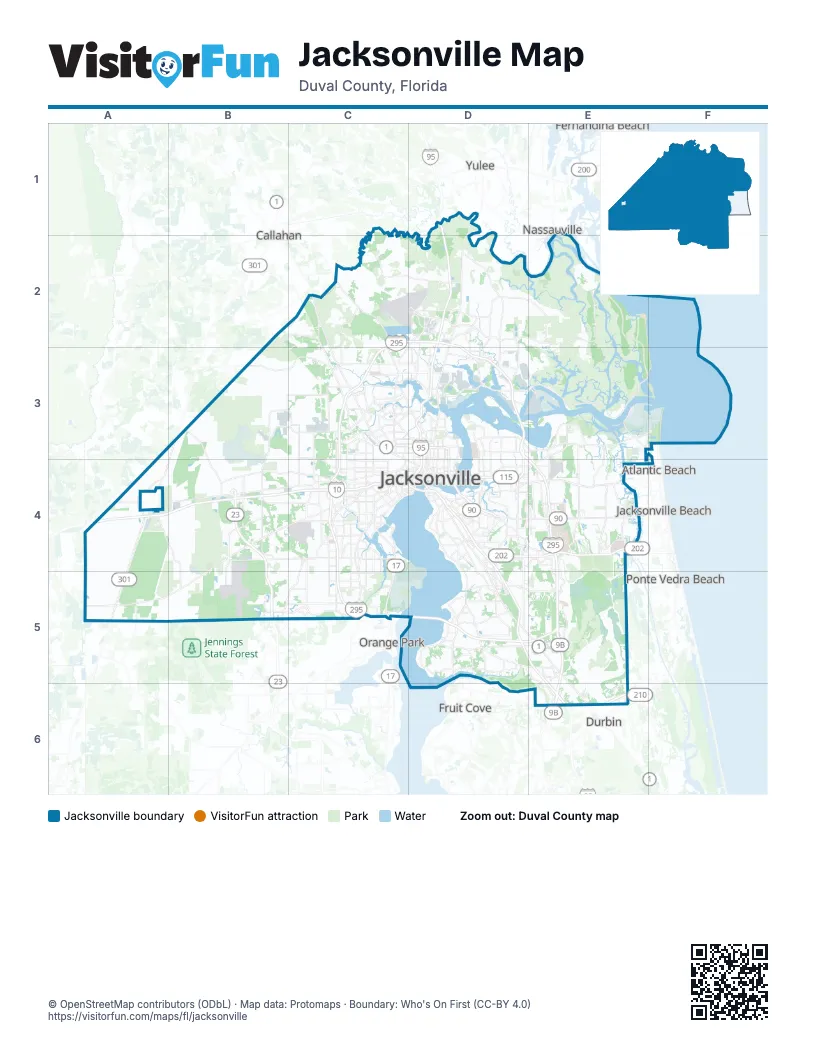
Street index of Jacksonville
Each street on the sheet and the grid squares it crosses.
- West BeltwayC2, D2, C3, C4, C5, D5
- East BeltwayD2, D3, E4, D5, E5
- Martin Luther King Jr. ParkwayD3, D4
- Southside ConnectorD3, D4
- First Coast ExpresswayB4, B5
- Roosevelt BoulevardC4
- Acosta ExpresswayD4
- Arlington ExpresswayD4
- Butler BoulevardD4, E4
- Commodore Point ExpresswayD4
- Emerson Street ExpresswayD4
- Fuller Warren BridgeD4
- Haines Street ExpresswayD4
- Hart ExpresswayD4
- J. Turner Butler BoulevardD4
- East Beltway Express LanesE4, E5
- I-295 Express LanesD5
- Nocatee ParkwayE6
Places on the map
- Alderman Park
- Amelia View
- Anheuser-Busch Brewery
- Arbor Oaks
- Arbor Pointe
- Arlington Green
- Arlington Hills
- Arlington Manor
- Arlingwood
- Ashley Woods
- Atla Lakes
- Atlantic Beach Country Club
- Bainebridge Estates
- Baldwin Yard
- Barrington Cove
- Bartram Creek
- Bartram Springs
- Batram Park Preserve
- Beach Road Farms
- Beacon Hills & Harbor
- Bent Creek Golf Course
- Bentwater Place
- Betz-Tiger Point Preserve
- Big Talbot Island State Park
- Blount Island
- Blue Sky Golf Club
- Bowden Yard
- Broadwater
- Cambridge Estates
- Camp Milton Historic Preserve
- Cary State Forest
- Castaway Island Reserve
- Cecil Field Golf Course
- Charter Point
- CMC Steel
- Cobblestone
- Colony Cove
- Cormorant Landing
- Countryside Village
- Creston
Next to Jacksonville
- Atlantic Beach
- Callahan
- Durbin
- Fernandina Beach
- Fruit Cove
- Jacksonville Beach
- Nassauville
- Orange Park
- Ponte Vedra Beach
- Yulee
© OpenStreetMap contributors (ODbL) · Map data: Protomaps · Boundary: Who's On First (CC-BY 4.0)