

Florida map
Sarasota map
About 57,764 people live here (Census Bureau, 2024 estimate). The sheet's index lists 300 streets; Fruitville Road, Tamiami Trail and 8th Street cross the most grid squares. Things to do inside the boundary: John and Mable Ringling Museum of Art, Mote Science Education Aquarium (Mote SEA) and Sarasota Jungle Gardens.
Open the map (PDF, US Letter)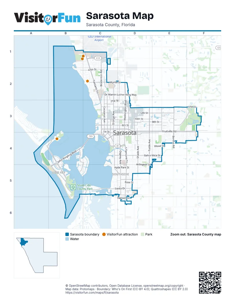
Street index of Sarasota
Each street on the sheet and the grid squares it crosses.
- Fruitville RoadC3, D3, E3, F3
- Tamiami TrailC1, C2, C3, C4
- Washington BoulevardD2, D3, D4
- South Tamiami TrailD4, D5, D6
- University ParkwayC1
- Mound StreetC4, D4
- Bayfront DriveC4
- Hansen StreetD6
- John Ringling BoulevardB4, C4, B5
- South Tuttle AvenueD4, D5
- South Osprey AvenueD4, D5
- North Tuttle AvenueD3, D4
- Siesta DriveC5, D5
- North Beneva RoadE3
- 17th StreetC3, D3, F3
- South Beneva RoadE3, E4
- Boulevard of the PresidentsB4, B5
- John Ringling ParkwayA4, B4
- North Washington DriveB4
- Bay RoadC5, D5
- Bee Ridge RoadD5
- Higel AvenueC5
- Saint Armands CircleB4
- Beneva RoadE4
- Bradenton RoadC1, C2
- 12th StreetC3, D3, E3
- Ringling BoulevardC4, D4, E4
- 10th StreetC3, D3, E3
- 8th StreetC3, D3, E3, F3
- Cocoanut AvenueC2, C3, C4
- Bahia Vista StreetC4, D4, E4
- North Orange AvenueC2, C3, C4
- Ben Franklin DriveB5
- Central AvenueC2, C3, C4
- South Shade AvenueD4, D5
- Myrtle StreetC2, D2
- Main StreetC4, D4, E4
- 6th StreetC3, D3, E3
- North Osprey AvenueD2, D3, D4
- North Lemon AvenueC2, C3, C4
- East StreetD3, D4
- Dr Martin Luther King WayC2, D2
- Boulevard of the ArtsC3
- South Orange AvenueC4, C5
- North Lockwood Ridge RoadE3
- South Boulevard of the PresidentsB4, B5
- Circus BoulevardE3, F3
- Bird Key DriveB4, C4, B5
- 47th StreetB2, C2
- North Lime AvenueD3, D4
- 19th StreetC3, D3
- South Washington DriveB4, B5
- Webber StreetD5
- South Lime AvenueD4
- Airport CircleC1
- North Shade AvenueD3, D4
- South Pineapple AvenueC4
- McClellan ParkwayC5, D5
- North Gulfstream AvenueC4
- Marina PlazaC4
- Taft DriveB5
- DeSoto RoadC1
- South Lemon AvenueC4
- Rick Piccolo CircleC1
- North School AvenueD3, D4
- Boulevard of PresidentsB5
- LongmeadowF3
- Glen Oaks Manor DriveE3
- Bay Shore RoadB1, C1, B2, C2
- South School AvenueD4, D5, D6
- Hillview StreetC5, D5
- Wood StreetD4, E4
- Arlington StreetC5, D5
- Hyde Park StreetC5, D5
- Bay StreetD4, E4
- Floyd StreetC4, D4, E4
- Hawthorne StreetC4, D4
- Waldemere StreetC4, D4
- North Jefferson AvenueD3, D4
- 32nd StreetC2, D2
- 4th StreetC3, D3
- Gillespie AvenueD2, D3
- Goodrich AvenueC2, C3, C4
- Prospect StreetC4, D4, E4
- 15th StreetC3, D3, E3
- Browning StreetD4, E4
- 7th StreetC3, D3, E3
- South East AvenueD4, D5
- 5th StreetC3, D3, D6
- 2nd StreetC3, D3
- Aspinwall StreetD3, E3
- 21st StreetD2, C3, D3
- Novus StreetD4, E4
- Mecca DriveB1, C1
- 22nd StreetC2, D2, C3
- Clematis StreetD5
- Royal Palm AvenueC1, C2
- 18th StreetC3, D3
- Wisteria StreetD5
- 40th StreetC2
- South Jefferson AvenueD4, D5
- 1st StreetC3, D3
- 9th StreetC3, D3
- Datura StreetD5
- Davis BoulevardD4, E4
- Alta Vista StreetC4, D4, E4
- Tarpon AvenueE3
- Hatton StreetD4, E4
- 24th StreetC2, D2
- 42nd StreetC2
- Loma Linda StreetC4, D4
- Harbor DriveC4
- 29th StreetC2, D2
- Hibiscus StreetD5
- Rhodes AvenueE3, E4
- North Conrad AvenueE3
- South Brink AvenueE4
- Huntington Place DriveE3
- 23rd StreetC2, D2
- 41st StreetC2
- 25th StreetC2, D2
- North Pompano AvenueE3
- South Palm AvenueC4
- Oak StreetC4, D4, E4
- Bougainvillea StreetD5
- South Euclid AvenueD4
- Rose StreetD5
- Temple StreetD4
- Ken Thompson ParkwayB4
- 11th StreetC3, D3
- Villagio CircleD3, E3
- Laurel StreetC4, D4
- Grove StreetD5
- Cheshire SquareE3
- North Briggs AvenueD3, D4
- Goldenrod StreetD5
- Village Garden DriveC1, C2
- Rilma AvenueC1, C2
- Highland StreetC2
- 31st StreetC2, D2
- 20th StreetC3, D3
- Courtland StreetD4, E4
- South Briggs AvenueD4
- South Gulfstream AvenueC4
- 13th StreetC3, D3
- Village Gardens DriveC1, C2
- Irving StreetC4, D4, E4
- Breezemont DriveE3
- Calliandra DriveE3, F3
- Leon AvenueC2, C3
- 45th StreetB2, C2
- North Euclid AvenueD3, D4
- Colorado StreetD4, E4
- Florida AvenueC3
- 34th StreetC2, D2
- Old Bradenton RoadC1, C2
- 16th StreetC3, D3
- Westway DriveA4, B4
- Alameda AvenueC2, C3
- The Gardens DrivewayF3, F4
- 14th StreetC3
- Glen Oaks Drive EastE3
- College DriveB1, C1
- North Brink AvenueE3
- Dixie AvenueD2, D3
- Golden Gate PointC4
- Maple AvenueC2, C3
- Morrill StreetC4, D4
- Brink AvenueE3, E4
- Signal Pointe CircleE3, E4
- Patterson DriveC2
- Rental Car RoadC1
- Tami Sola StreetD4
- Eastchester DriveC1, C2
- South Lockwood Ridge RoadE4
- South Polk DriveB5
- Stevens DriveC1, C2
- Midwest ParkwayE3, E4
- Palmadelia AvenueC2, C3
- Seeds AvenueD3
- 46th StreetC2
- Meadow Lark DriveC4, C5
- Air Cargo AvenueC1
- Hillview DriveC4, C5
- Magnolia StreetD5
- Orchid StreetD5
- Belvoir BoulevardD4
- Prairie View Drive NorthF4
- Winchester DriveC1, C2
- Pin Oaks StreetE3
- Saralake BoulevardE4
- La Costa CircleD3
- South Pompano AvenueE3, E4
- Sunnyside LaneD5
- Island Park DriveC4
- Cheshire LaneE3
- Golden Sands DriveE3, E4
- Ramblewood Drive NorthE3
- Robin DriveB4
- Saralake Drive SouthE4
- Oakwood Boulevard SouthE4
- East AvenueD4, D5
- North Links AvenueD2, D3
- Sunnyside PlaceD5
- Mango AvenueD3
- Norsota WayC5
- Partridge CircleC4, C5
- 36th StreetC2, D2
- Pelican DriveD4
- Pattison AvenueE4
- Apricot AvenueD3
- Tyler DriveB5
- South Shore DriveB1, B2
- Jefferson CircleD5
- Pershing AvenueD2
- Pomelo AvenueC4
- East Royal Flamingo DriveB4, C4
- Glengary StreetD6
- Charlotte AvenueD4
- East Cornelius CircleE4
- Club Mar DriveD3
- 33rd StreetC2, D2
- South Allendale AvenueD4
- 38th StreetC2
- Bailey RoadE3
- Freeling DriveC5
- Mourning Dove DriveB5, C5
- Lynnhurst StreetD4
- Sarasota AvenueC2
- South DriveC5, D5
- 35th StreetC2, D2
- Audubon PlaceD3, D4
- Ringling PlazaB1, C1
- Indian Beach DriveC2
- Allenwood StreetE3
- Barrington CircleC1
- Brywill CircleB1, B2
- Washington CourtD2
- Dodge AvenueE3
- Laurel Oak WayE4
- 44th StreetC2
- Tallywood DriveE3
- Four Seasons CircleC1
- Flamingo AvenueC5
- Cherokee DriveC5, D5
- Corwood DriveB2, C2
- Rawls AvenueC4
- Camino RealC5
- Seagull LaneB4, C4
- North DriveC5, D5
- Oakwood Boulevard WestE4
- Maggie LaneE3, E4
- Tangier TerraceC5
- Flower DriveC4, C5
- West Cornelius CircleE4
- 39th StreetC2
- North Shore DriveB1
- Bayview DriveC5, D5
- Tangier WayC5
- Carolina AvenueC2
- Cleveland DriveB5
- Bay Point DriveC4
- Lincoln DriveD4
- Dividing Creek DriveE3
- Hawkins CourtD4
- West Royal Flamingo DriveB4, B5
- Payne ParkwayD4
- Wisconsin LaneC5, D5
- Adelia AvenueC3, C4
- Amherst AvenueE3
- Riverside DriveC2
- Adams LaneD4
- Panama DriveC2, C3
- David AvenueC1, C2
- Mimosa CircleF4
- Princeton StreetD3
- 52nd StreetC1
- Bailey StreetE3
- Bobby Jones RoadE3, F3
- Madison DriveB4
- North Spoonbill DriveB5, C5
- Sun CircleB1, B2
- Oakwood BoulevardE3, E4
- Winton AvenueC2
- Sydelle StreetD4
- Shoreland DriveC5, D5
- Mc Kinley DriveB5
- Bearded Oaks CircleE4
- Ramblewood Drive SouthE3
- Van Wezel WayC3
- Cornell StreetD3
- Parkland AvenueE4
- 10th WayC3, D3
- Flores AvenueC5
- Cunliff LaneC5, D5
- Sapphire DriveB1
- Sunridge DriveC1
- Marlin DriveC1, C2
- Church AvenueD2
- Spring Creek DriveC5, D5
Things to do on the Sarasota map
Places on the map
- Advance Auto Parts
- ALDI
- Alfred R. Goldstein Library
- Aloft by Marriott Sarasota
- Alta Vista Street
- Americas Best Value Inn
- Babe Ruth Park
- Bayfront Park
- Bird Key Park
- Bobby Jones Golf Club
- Booker High School
- Brookside Middle School
- Centennial Park
- Cirque St Armands Beachside
- Glengarry Post Office
- Hotel Indigo Sarasota
- Hyatt Regency
- Ken Thompson Park
- Marie Selby Botanical Gardens
- New College of Florida
- Pansy Bayou
- Payne Park
- Ringling Bridge Causeway Park
- Ringling College of Art and Design
- Ringling Museum Complex
- Saint Armand's Circle
- Saint Martha's Catholic School
- Sarasota Commons
- Sarasota Memorial Hospital
- Sarasota Sands Resort
- South Lido County Park
- The Ritz-Carlton Beach Club
- The Ritz-Carlton, Sarasota
- The UPS Store
- The Westin Sarasota
- Town & Country Plaza
- Water Tower Park
- Westfield Siesta Key
- Westfield Southgate
© OpenStreetMap contributors, Open Database License, openstreetmap.org/copyright · Map data: Protomaps · Boundary: Who's On First (CC-BY 4.0); Quattroshapes (CC BY 2.0)