

Florida map
St. Lucie County map
About 390,670 people live here (Census Bureau, 2024 estimate). The sheet's index lists 74 streets; Florida's Turnpike, US Highway 1 and South Ocean Drive cross the most grid squares. Also on it: Aero Acres Airport, Avalon Crossing and Azalea.
Open the map (PDF, US Letter)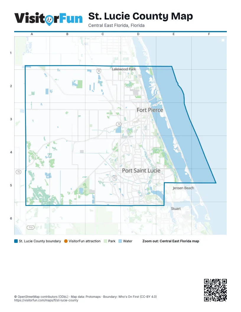
Maps inside St. Lucie County
1 map inside, from the street map of St. Lucie County down.
Street index of St. Lucie County
Each street on the sheet and the grid squares it crosses.
- Florida's TurnpikeA1, A2, B2, C2, C3, D3, D4, D5, D6
- 43rd Avenue SouthwestC1
- Emerson AvenueC1, C2
- Johnston RoadC1, C2
- Highway A1AD1, D2, E2
- Turnpike Feeder RoadD1, D2
- US Highway 1D1, D2, D3, D4, E4, E5
- Indrio RoadC2, D2
- Angle RoadD2, D3
- Causeway DriveD2
- North 25th StreetD2, D3
- North 4th StreetD2, D3
- North Fed HighwayD2
- North Kings HighwayD2, D3
- Saint Lucie BoulevardD2
- State Road A1AD2
- West Angle RoadD2
- Atlantic Beach BoulevardE2
- Seaway DriveE2, D3, E3
- South Ocean DriveE2, E3, E4, E5, F5
- Northeast 224th StreetA3
- Orange AvenueA3, B3, C3, D3
- Okeechobee RoadC3, D3, A4, B4, C4
- Citrus AvenueD3
- Delaware AvenueD3
- Edwards RoadD3
- Glades Cut Off RoadD3, C4, D4, C5
- Oleander AvenueD3
- Oleander BoulevardD3, D4
- Selvitz RoadD3, D4
- South 25th StreetD3, D4
- South Indian River DriveD3, E3, E4, E5
- South Jenkins RoadD3
- South Kings HighwayD3
- Sunrise BoulevardD3
- Virginia AvenueD3
- Northwest Saint Lucie West BoulevardC4, D4
- Southwest Saint Lucie West BoulevardC4, D4
- West Midway RoadC4, D4
- Crosstown ParkwayD4, E4, C5, D5
- East Midway RoadD4, E4
- East Prima Vista BoulevardD4
- Northeast Airoso BoulevardD4
- Northeast Prima Vista BoulevardD4
- Northeast Saint James DriveD4
- Northwest Airoso BoulevardD4
- Northwest Bayshore BoulevardD4
- Northwest Prima Vista BoulevardD4
- Northwest Saint James DriveD4
- Prima Vista BoulevardD4
- Southeast Airoso BoulevardD4, D5
- Southeast Prima Vista BoulevardD4
- Southwest Bayshore BoulevardD4, D5
- Southwest Prima Vista BoulevardD4
- Range Line RoadC5, C6
- Southwest Becker RoadC5, C6, D6
- Southwest Gatlin BoulevardC5, D5
- Southwest Village ParkwayC5
- Tradition ParkwayC5
- Village ParkwayC5, C6
- Southeast Midport RoadD5
- Southeast Port Saint Lucie BoulevardD5, E5
- Southeast Veterans Memorial ParkwayD5, E5
- Southwest Port Saint Lucie BoulevardD5, D6
- Federal HighwayE5
- Northeast Indian River DriveE5
- Southeast Lennard RoadE5
- Southeast Mariposa AvenueE5
- Southeast Walton RoadE5
- Walton RoadE5
- Northeast Ocean BoulevardF5
- Dairy RoadC6
- Southeast Becker RoadD6, E6
- Northwest Gilson RoadE6
Places on the map
- Aero Acres Airport
- Avalon Crossing
- Azalea
- Bella Strano
- Blind Creek Beach North
- Blind Creek Beach South
- Calle de Lagos
- Cascades at Saint Lucie West
- Cemex
- Chupco's Landing
- Citrus Hammock Natural Area
- Commercial Circle
- East Port Plaza
- Fairwinds Golf Course
- Floridian Golf Club
- Fort Pierce
- Fort Pierce City Marina
- Fort Pierce Inlet State Park
- Fort Pierce North
- Fort Pierce Reservation
- Fort Pierce South
- Gatlin Plaza
- Gator Trace Golf & Country Club
- Gordy Road Preserve
- Greene Swamp Preserve
- HCA Florida Lawnwood Hospital
- Hidden Acres
- Hutchinson Island South
- Indian Hills Golf Course
- Indian River Lagoon
- Indrio Savannahs Preserve
- Island Pines Golf Club
- John B Sports Complex
- Kings Isle
- Kitterman Woods
- La Buona Vita
- Lake Brian
- Lake Dan
- Lake John
- Lake Lucie
Next to St. Lucie County
- Jensen Beach
- Stuart
© OpenStreetMap contributors (ODbL) · Map data: Protomaps · Boundary: Who's On First (CC-BY 4.0)