

Florida map
Stuart map
About 19,566 people live here (Census Bureau, 2024 estimate). The sheet's index lists 287 streets; Southeast Federal Highway, Northwest Federal Highway and Southeast 5th Street cross the most grid squares. Also on it: Haney Creek Park, Regency Square and Stuart Square.
Open the map (PDF, US Letter)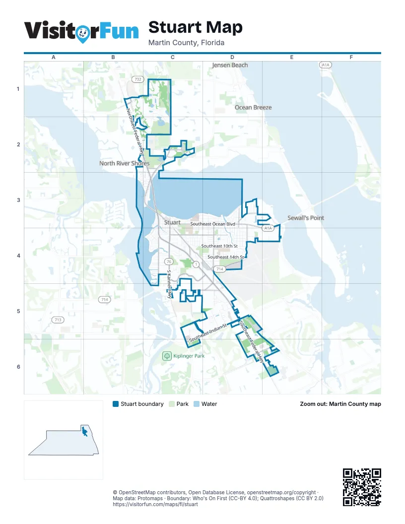
Street index of Stuart
Each street on the sheet and the grid squares it crosses.
- Goldenrod RoadB1
- Northwest Britt RoadB1
- Northwest Federal HighwayB1, B2, C2, C3
- Northwest Fresco WayB1
- Northwest Waterlily PlaceB1, B2
- Northwest Bayonet PlaceC1
- Northwest Bellworth PlaceC1
- Northwest Canna WayC1
- Northwest Dewburry TerraceC1
- Northwest Ember WayC1
- Northwest Emilia WayC1
- Northwest Fetterbrush WayC1
- Northwest Fowler AvenueC1
- Northwest Jensen Beach BoulevardC1
- Northwest Pine Sap PlaceC1
- Northwest Sunflower PlaceC1, C2
- Northwest Tulip WayC1
- Northwest Windemere DriveC1, B2, C2
- Northwest Windflower TerraceC1, C2
- Southeast Green River ParkwayC1, C2
- Northwest Baker RoadB2, C2
- Northwest Buck Hendry WayB2
- Northwest Fork RoadB2, C2
- Northwest Marsh Rabbit LaneB2, C2
- Northwest North River DriveB2, B3, C3
- Northwest River Shores StreetB2, C2
- North Baseline AvenueC2
- Northeast 15th StreetC2
- Northeast Baker RoadC2
- Northeast Cardinal AvenueC2
- Northeast Dixie HighwayC2
- Northeast Oriole AvenueC2
- Northeast Savannah RoadC2
- Northeast Seneca AvenueC2
- Northwest Alice StreetC2
- Northwest Charlie Green DriveC2
- Northwest Dalea WayC2
- Northwest Dixie HighwayC2, C3
- Northwest Flagler AvenueC2, C3
- Northwest Waterwillow WayC2
- Northwest Wright BoulevardC2
- Northwest New Providence RoadB3
- Northwest Terrace RoadB3, C3
- Northwest Treasure RoadB3
- Confusion CornerC3
- Northwest Australian StreetC3
- Northwest Fern StreetC3
- Northwest Oleander StreetC3
- Northwest Palm StreetC3
- Northwest Poinsettia StreetC3
- Northwest Stuart AvenueC3
- Roosevelt BridgeC3
- South Colorado AvenueC3, C4
- Southeast 5th StreetC3, D3, C4, D4
- Southeast Amerigo AvenueC3, C4
- Southeast Denver AvenueC3
- Southeast Detroit AvenueC3
- Southeast Flagler AvenueC3, C4
- Southeast Florida AvenueC3
- Southeast Georgia AvenueC3, C4
- Southeast High School AvenueC3, C4
- Southeast Hospital AvenueC3
- Southeast Illinois AvenueC3
- Southeast Ocean BoulevardC3, D3, E3, E4
- Southeast Osceola StreetC3, D3
- Southeast Riverside DriveC3, D3
- Southeast Seminole StreetC3
- Southeast Stypmann AvenueC3
- Southeast Weir StreetC3, D3
- Southwest 3rd StreetC3
- Southwest 5th StreetC3
- Southwest Akron AvenueC3, C4
- Southwest Albany AvenueC3
- Southwest Anchorage WayC3
- Southwest Atlanta AvenueC3
- Southwest California AvenueC3, C4
- Southwest Camden AvenueC3, C4
- Southwest Colorado AvenueC3
- Southwest Dixie HighwayC3
- Southwest Federal HighwayC3, C4
- Southwest Flagler AvenueC3
- Southwest Joan Jefferson WayC3
- Southwest Ocean BoulevardC3
- Southwest Osceola StreetC3
- Southwest Saint Lucie AvenueC3
- Southwest Seminole StreetC3
- Southeast Alamanda WayD3, D4
- Southeast Balboa AvenueD3, D4
- Southeast Cardinal WayD3
- Southeast Coconut AvenueD3, D4
- Southeast Cortez AvenueD3, D4
- Southeast Dolphin DriveD3, D4
- Southeast Dunscombe RoadD3
- Southeast Edgewood DriveD3
- Southeast Egret PlaceD3
- Southeast Fini DriveD3, D4
- Southeast Flamingo AvenueD3, D4
- Southeast Four Winds DriveD3
- Southeast Fourwinds DriveD3
- Southeast Hibiscus AvenueD3, D4
- Southeast Krueger Creek PlaceD3, D4
- Southeast Krueger ParkwayD3, D4
- Southeast Lark BoulevardD3
- Southeast Madison AvenueD3, D4
- Southeast Mango PlaceD3
- Southeast Martin AvenueD3
- Southeast Monterey AvenueD3
- Southeast Monterey RoadD3, D4, C5, D5
- Southeast Oriole AvenueD3
- Southeast Palm Beach RoadD3, D4
- Southeast Parkway DriveD3, D4
- Southeast Pelican DriveD3
- Southeast Pierpoint DriveD3
- Southeast River Lights CourtD3
- Southeast Robalo CourtD3, D4
- Southeast Sailfish LaneD3
- Southeast Saint Lucie BoulevardD3
- Southeast Wentworth DriveD3
- East Spruce AvenueC4
- Frazier Creek CircleC4
- South Bahama AvenueC4
- South Kanner HighwayC4, C5
- Southeas Mcdonald LaneC4
- Southeast 10th StreetC4, D4
- Southeast 14th StreetC4, D4
- Southeast 15th StreetC4, D4
- Southeast 6th StreetC4, D4
- Southeast Angler DriveC4
- Southeast Bahama AvenueC4
- Southeast Bayou AvenueC4
- Southeast Beech Tree LaneC4
- Southeast Broadway StreetC4
- Southeast Casa AvenueC4
- Southeast Central AvenueC4
- Southeast Central ParkwayC4, D4
- Southeast Church StreetC4
- Southeast Contractors WayC4
- Southeast Cutoff RoadC4
- Southeast Decker AvenueC4
- Southeast Delaware AvenueC4
- Southeast Dixie HighwayC4, D4
- Southeast East AvenueC4
- Southeast Federal HighwayC4, D4, D5, D6, E6
- Southeast Florida StreetC4
- Southeast Halifax LaneC4
- Southeast Hancock StreetC4
- Southeast Harper StreetC4
- Southeast Hillcrest AvenueC4
- Southeast Hudson CourtC4
- Southeast Ila StreetC4
- Southeast Jillanne DriveC4
- Southeast Johnson AvenueC4
- Southeast Kindred StreetC4
- Southeast Kitching CircleC4
- Southeast Lake StreetC4, D4
- Southeast Lincoln AvenueC4
- Southeast Lonita StreetC4
- Southeast Martin Luther King BoulevardC4, D4
- Southeast Midway StreetC4
- Southeast Nassau AvenueC4
- Southeast Palermo CourtC4, C5
- Southeast Parakeet LaneC4
- Southeast Park AvenueC4
- Southeast Pathfinder AvenueC4, D4
- Southeast Prescott PlaceC4
- Southeast Ray's WayC4, C5
- Southeast Rogers CourtC4
- Southeast Sea Hunt WayC4
- Southeast Sedona CircleC4, C5
- Southeast Stypman BoulevardC4, D4
- Southeast Stypmann BoulevardC4
- Southeast Tarpon AvenueC4
- Southeast Tressler DriveC4
- Southeast Villas StreetC4
- Southwest 6th StreetC4
- Southwest 7th StreetC4
- Southwest A StreetC4
- Southwest B AvenueC4
- Southwest Bryant AvenueC4
- Southwest Channel AvenueC4
- Southwest Cleveland AvenueC4
- Southwest Dyer DriveC4
- Southwest Elizabeth LaneC4
- Southwest G StreetC4
- Southwest Halpatiokee StreetC4
- Southwest Indian Groves DriveC4
- Southwest Indian River CourtC4
- Southwest Indianola StreetC4
- Southwest Manor DriveC4
- Southwest McPherson StreetC4
- Southwest North Carolina DriveC4
- Southwest Norton's LaneC4
- Southwest Overlook DriveC4
- Southwest Palm City RoadC4
- Southwest Pine AvenueC4
- Southwest Ridge LaneC4
- Southwest River Point DriveC4
- Southwest Riverdale StreetC4
- Southwest Rivers Edge DriveC4
- Southwest Riverview AvenueC4
- Southwest Saint Lucie CrescentC4
- Southwest Siesta WayC4
- Southwest South Carolina DriveC4
- Southwest South River Point DriveC4
- Southwest Winnachee DriveC4
- Dixie HighwayD4
- Southeast 11th StreetD4
- Southeast 12th StreetD4
- Southeast 13th StreetD4
- Southeast 15th CourtD4
- Southeast 16th CourtD4
- Southeast 16th StreetD4
- Southeast 18th StreetD4
- Southeast 7th StreetD4
- Southeast 8th StreetD4
- Southeast 9th StreetD4
- Southeast Alamanda CircleD4
- Southeast Alamanda LaneD4
- Southeast Andrews StreetD4
- Southeast Apache AvenueD4
- Southeast Arapaho AvenueD4
- Southeast Christie WayD4
- Southeast Dixie LaneD4
- Southeast Forest Park DriveD4
- Southeast Garden CourtD4
- Southeast Hall StreetD4
- Southeast Kingswood TerraceD4, E4
- Southeast Lake Clare PlaceD4
- Southeast Lawler CourtD4
- Southeast Michaels CourtD4
- Southeast Monterey Commons BoulevardD4
- Southeast Ocean AvenueD4
- Southeast Paul StreetD4
- Southeast Pine Castle CourtD4
- Southeast Saint Joseph's Avenue EastD4
- Southeast Saint Joseph's Avenue WestD4
- Southeast Saint Josephs AvenueD4
- Southeast Sand Dollar LaneD4
- Southeast Sandpiper LaneD4
- Southeast Sea Oat LaneD4
- Southeast Seashell LaneD4
- Southeast Stafford DriveD4
- Southeast Starfish LaneD4
- Southeast Theresa StreetD4
- Southeast Gatehouse CircleC5
- Southeast Indian StreetC5, D5, C6
- Southeast Jake CourtC5
- Southeast Ruhnke StreetC5, D5
- Southeast Sarah CourtC5
- Southeast Seville StreetC5
- Southeast Willoughby BoulevardC5
- Southwest Monterey RoadC5
- Asterwood PlaceD5
- Indian PinesD5
- Southeast Aster LaneD5
- Southeast Astorwood PlaceD5
- Southeast Birmingham DriveD5
- Southeast Carnivale CourtD5
- Southeast Commerce AvenueD5, E5, E6
- Southeast Edler DriveD5
- Southeast Fischer StreetD5
- Southeast Glenwood DriveD5
- Southeast Grumman Boulevard ExtensionD5
- Southeast Letha CircleD5
- Southeast Letha CourtD5
- Southeast Lexington Lakes DriveD5
- Southeast Luckhardt StreetD5
- Southeast Martin Square Corporate ParkwayD5
- Southeast Miami AvenueD5, E5, D6
- Southeast Monterey Road ExtensionD5
- Southeast New Hampshire WayD5
- Southeast Palm CourtD5
- Southeast Parkview PlaceD5
- Southeast Sheffield TerraceD5
- Southeast Wayne RoadD5
- Southeast Wilshire PlaceD5
- Southeast Pomeroy StreetD6
- Southeast Washington StreetD6
- Southeast Dominica TerraceE6
- Southeast Gay StreetE6
- Southeast Harrison StreetE6
- Southeast Jackson StreetE6
- Southeast Madison StreetE6
- Southeast Market PlaceE6
- Southeast Monroe StreetE6
- Southeast Slater StreetE6
- Southeast Springtree PlaceE6
Places on the map
- ABC Liquors
- Advantage Ford
- ALDI
- Asian Specialty Products
- Audubon of Martin County
- AutoZone
- Aycock Funeral Home
- Blake Library
- Bono's
- Building #3
- Building #4
- Building #6
- Carrabba's Italian Grill
- Casa Tequila
- Central Marine Marina
- Chase
- Chick-fil-A
- Church of Christ at Stuart
- Church of God by Faith
- Circuit Court Clerk
- Citgo
- Cleveland Clinic Family Health Center
- East Coast Greenway
- Fern Hill Cemetery
- Flagler Park
- Guy Davis Ballfield and Park
- Haney Creek Park
- Haney Creek Park Nature Trails & Dog Park
- JD Parker Elementary School
- Loggerhead Marina Stuart
- Martin County Center Preserve
- Martin North Hospital
- Poppleton Creek Pond Park
- Regency Square
- Sailfish Park
- Stuart Middle School
- Stuart Square
- Sunset Bay Marina & Anchorage
- Walmart Supercenter
Next to Stuart
- Jensen Beach
- North River Shores
- Ocean Breeze
- Sewall's Point
© OpenStreetMap contributors, Open Database License, openstreetmap.org/copyright · Map data: Protomaps · Boundary: Who's On First (CC-BY 4.0); Quattroshapes (CC BY 2.0)















