

Florida map
Martin County map
About 165,666 people live here (Census Bureau, 2024 estimate). The sheet's index lists 300 streets; Southwest Warfield Boulevard, Southwest Kanner Highway and Florida's Turnpike cross the most grid squares. Things to do inside the boundary: PonTiki Boat Cruises.
Open the map (PDF, US Letter)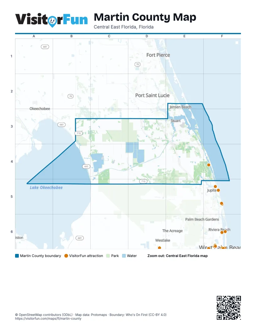
Maps inside Martin County
1 map inside, from the street map of Martin County down.
Street index of Martin County
Each street on the sheet and the grid squares it crosses.
- Florida's TurnpikeD3, E3, E4, E5
- Southeast Federal HighwayE3, E4, F4, F5
- Southwest Martin HighwayB3, C3, D3, E3
- Southwest Warfield BoulevardB3, C3, C4, D4, D5
- Southwest Kanner HighwayE3, B4, C4, D4, E4
- Conners HighwayB3, B4, B5, C5
- South Kanner HighwayE3
- Southwest Martin Downs BoulevardD3, E3
- Northwest Federal HighwayE2, E3
- Northeast Ocean BoulevardE2, E3
- Southeast Monterey RoadE3
- Southeast Ocean BoulevardE3
- Federal HighwayE2
- Roosevelt BridgeE3
- Southwest Federal HighwayE3
- Southwest Monterey RoadE3
- Southwest Indiantown AvenueD4
- Kanner HighwayE4
- South Ocean DriveE2
- Southwest Citrus BoulevardD3, C4, D4
- Southwest Allapatah RoadC3, C4
- Southeast Bridge RoadE4, F4
- Southeast Dixie HighwayE3, E4, F4
- Pratt Whitney RoadE4, E5
- Dixie HighwayE3, E4, F4
- Southeast Cove RoadE3
- Southwest High Meadow AvenueD3, E3
- Southeast Indian StreetE3
- Southwest Bridge RoadD4, E4
- Southwest Pratt Whitney RoadE4
- Northeast Indian River DriveE2, E3
- Southwest 96th StreetD4, E4
- Northwest Jensen Beach BoulevardE2
- Southwest Newfield ParkwayD3
- Northeast Jensen Beach BoulevardE2
- Northeast Causeway BoulevardE2
- Southwest Murphy RoadD3, E3
- North Sewall's Point RoadE3
- Citrus BoulevardD4
- Northeast Pineapple AvenueE2
- Murphy RoadD3, E3
- Northwest Gilson RoadE3
- Southwest Port Saint Lucie BoulevardD3
- Dairy RoadC3
- Southwest Fox Brown RoadC3, C4
- South Beach RoadF4, F5
- Southwest Farm RoadC4
- Southeast Willoughby BoulevardE3
- Southeast Saint Lucie BoulevardE3
- Southwest Mapp RoadE3
- Southeast Seabranch BoulevardE3, E4
- Southeast Salerno RoadE3
- Southeast Gomez AvenueE3, E4, F4
- Northeast Savannah RoadE2, E3
- Southeast Pomeroy StreetE3
- Northeast Dixie HighwayE3
- Southeast Green River ParkwayE2, E3
- Southeast County Line RoadF4, F5
- Southeast Commerce AvenueE3
- Southwest Berry AvenueE3
- Southeast Central ParkwayE3
- Southwest Silver Fox LaneC4
- Northwest Goldenrod RoadE2
- Southeast Macarthur BoulevardE3
- Northeast Skyline DriveE2, E3
- Southeast Horseshoe Point RoadE3
- Northwest Dixie HighwayE3
- Island WayE5
- Southwest Sunset TrailE3
- Northwest Britt RoadE3
- Southeast Martin Luther King BoulevardE3
- Southeast Kubin AvenueE3
- Southwest Palm City RoadE3
- Southeast Country Club DriveF4, F5
- Southeast Palm Beach RoadE3
- Goldenrod RoadE2, E3
- Southwest Matheson AvenueE3
- Mapp RoadE3
- Southeast Jefferson StreetE3
- Southeast Robertson RoadE3
- South Colorado AvenueE3
- Southwest Golden Bear WayE3
- Southeast Island WayE5, F5
- Southeast Osprey StreetE4
- Cove RoadE3
- Northeast Macarthur BoulevardE3
- Southwest Dr Martin L King Jr DriveC4
- Southeast Williams WayE3
- Northwest Baker RoadE3
- Southeast Loxahatchee River RoadE4, E5
- Southeast Lares AvenueE4, F4
- Southeast Crossrip StreetE4
- Southeast Pettway StreetE4
- Southwest Dixie HighwayE3
- Southwest Adams AvenueB4, C4
- Northeast Palmer StreetE3
- Northeast Baker RoadE3
- Northwest Westmoreland BoulevardE2
- Northeast Cardinal AvenueE3
- Old Dixie HighwayF5
- Southeast Martin AvenueE3
- Southeast Manatee Cove RoadE3
- Southeast Monterey Road ExtensionE3
- Southeast Little Club Way NorthF4
- Southeast Market PlaceE3
- Southeast Girl Scout Camp Road SouthF4
- Northeast County Line RoadE2
- Southeast Anchor AvenueE3
- Southeast Cutoff RoadE3
- Northwest Wright BoulevardE3
- Southeast Wooden Bridge LaneF4
- Southwest Palm WayC4
- Little ClubF4
- Southeast Christie WayE3
- County Line RoadE2
- Confusion CornerE3
- Frazier Creek CircleE3
- Southeast Pine Tree StreetE5
- Country Club DriveF5
- Southwest Boatramp AvenueD3
- Southeast Sand RoadE4, F4
- Herbert Hoover DikeB3, B4
- Southwest Stuart West BoulevardD3
- Northeast Pinecrest Lakes BoulevardE2, E3
- Southwest Stable RunD4
- Southwest Trailside PathD4, E4
- Southwest Hosanah LaneC3
- Southwest Minute Maid RoadC4, D4
- Southwest Sand AvenueD3
- Southwest Moore StreetD3
- Southeast Fairway WestE3
- Southeast Turtle Creek DriveF4, F5
- Southwest Rivers End WayD3, E3
- Southwest Leighton Farm AvenueD3
- Southeast Doubleton DriveE3
- Southwest Squire Johns LaneD3
- Southwest Secretariat DriveD3
- Southwest Long DriveD3
- Southeast Winged Foot DriveE3
- Southwest Markel StreetD3
- Gomez RoadF4
- Southeast 138th StreetE4
- Southeast Ranch RoadE4, E5
- Southwest Green Farms RoadD3
- Southeast Miles Grant RoadE3
- Southeast Double Tree DriveE4
- Southeast Heritage BoulevardE3, E4
- Southwest Crane Creek AvenueD3
- Southeast Mariner Sands DriveE3
- Southwest FP and L Access RoadC4
- Southeast Fairway EastE3
- Southwest Lost River RoadE3, E4
- Cross Bar RoadB3
- Southeast Eagle AvenueE3, E4
- Southwest Stoneybrook LaneD3
- Southeast Mack Dairy RoadE4, E5
- Northwest Fork RoadE3
- Southwest Bimini Circle SouthD3
- Southeast Harbor CircleE3
- Melear Dairy RoadB3
- Southwest Saint Andrews DriveD3
- Southwest Tommy Clements StreetC3, C4
- Southwest Busch StreetD3
- South River RoadE3
- Southwest Springhaven AvenueC3, C4
- Southwest Bimini Circle NorthD3
- Southwest Parkgate BoulevardE3
- L-63SB3
- Southwest Thistle TerraceE3
- Southeast Osceola StreetE3
- Southeast Colony WayE5
- Northwest Spruce Ridge DriveE3
- North Beach RoadF4
- South Sewalls Point RoadE3
- Southwest Woodham StreetD3
- Southwest Racquet Club DriveD3
- Southeast Ranch Acres CircleE4
- Southwest Hunter DriveC3
- Southwest Cherokee StreetD3
- Southeast Flora AvenueE4
- Southwest Waterfall BoulevardE3
- Southwest Sunlight Ranch DriveD4
- Southwest Gaines AvenueE3
- Southwest San Antonio DriveD3
- Southwest Grove StreetD3
- Southwest Osceola StreetE3, C4, D4
- Southwest Trailside RunE4
- Southwest English Garden DriveD3
- Southeast Village CircleF4
- Southwest Honey TerraceD3
- Southwest Longspur LaneE3
- Southwest Meadowlark CircleE4
- Northwest Mossy Oak WayE2
- Southwest Green Ridge LaneD4
- Monarch Club DriveE3
- Southwest Golden Glow DriveD3
- Southeast Riverfront TerraceE4, F4
- Southwest Groveside DriveD4
- Northwest Windemere DriveE2, E3
- Southwest Venetian DriveD3
- Southwest Ludlum StreetD4
- Northwest Pine Lake DriveE3
- Southeast Burning Tree CircleE3
- Southwest Deer Run AvenueC3
- Southwest Palm Cove DriveE3
- Southwest Locks RoadE3, E4
- Southeast Old Trail Drive EastE4, E5
- Southeast Bridgewater DriveE5
- Southwest Santa Monica DriveD3
- Southeast Twin Oaks CircleE3
- Southeast Eaglewood WayE4, F4
- Southwest Indian Mound DriveC4
- Northwest Royal Oak DriveE2
- Southwest Hammock Creek DriveD3, E3
- Morning Dove WayE3
- South East Golfhouse RoadE3, E4
- Southeast Plandome DriveE4
- Southwest Canoe Creek TerraceD3
- Southeast Constitution BoulevardE3, E4
- Southeast Monroe StreetE3
- Southwest 95th StreetC4
- Southwest Yachtmans DriveE4
- Southeast Preserve TraceE3, E4
- Southeast Retreat DriveE4
- Southwest Landing Creek DriveE3
- Southeast Legacy Cove CricleE3
- Southwest Rattlesnake RunD3
- Southwest Jack James DriveE3, E4
- Southwest 39th StreetD3
- Northwest Mall LoopE2, E3
- Southwest Sunset Trace CircleD3
- Southeast Swan AvenueE3, E4
- Southwest 33rd StreetD3, E3
- Southwest Martigale DriveD3
- Southeast 10th StreetE3
- Southeast Riverboat DriveE3
- Southeast Windsong LaneE3
- Southeast Graham DriveE3
- Southeast Heritage DriveF4
- Southwest 34th StreetE3
- Southeast Ashley Oaks WayE3, E4
- Southwest Pegasus WayD3
- Southeast Lexington AvenueE3, E4
- Southwest Gator TrailD3
- Southwest Sandhill RoadD3
- Southeast Rivers Edge StreetE4
- Southwest 86th StreetC4
- Southwest Pine Tree LaneE3
- Medalist PlaceE4
- Southwest Pentalago CircleD3
- Wild Turkey LaneC3
- Southeast Ault AvenueE3
- Southeast Riverside DriveE3
- Southwest Lighthouse DriveE3
- Southeast Old Trail Drive WestE4, E5
- Southeast Westminster PlaceE3
- Southeast Paulson AvenueE3, E4
- Southwest Dyer Point RoadE3
- Northwest Treasure Coast DriveE2
- Southeast Tailwinds RoadE5
- Southwest Foxpoint TrailE3
- Southeast Major WayE3
- Southeast Summerfield WayE3
- Southeast 14th StreetE3
- Southwest Swallowtail WayE3
- Southeast Flamingo AvenueE3
- Southwest Morgan StreetC4
- Southeast Old Plantation CircleE5
- Southeast Florida AvenueE3, E4
- Southwest 42nd AvenueD3
- Southwest Savage AvenueD3
- Southwest Zarrella StreetD4
- Northeast Ginger TerraceE3
- Southwest Danforth CircleE3
- Southwest Hawk View CircleE4
- Southwest 84th AvenueD3
- Southeast Community DriveE3
- Southwest Arrowroot RoadC4
- Southwest 42nd Street EastD3
- Southwest Palomino StreetC4
- Southeast Darling StreetE3
- Southwest Cornell AvenueE3
- Southwest Linden StreetE3
- Southwest Lake Grove CircleE3
- Southwest Feroe AvenueE3
- Southwest Panther TraceE4
- Southeast Tres Belle CircleE3
- Southwest Indianwood CircleC4
- Southwest Groveview TerraceD4
- Southwest Bulldog WayE4
- Southwest Oak Ridge RoadE3
- Southeast Duncan StreetE4, F4
- Southwest Seminole DriveC4
- Southwest Key Deer LaneE3
- Southwest Balmoral TraceE4
- Southeast Waterford DriveE3
- Southwest Blue Water WayE3
- Southwest Old Kansas AvenueE4
- Southeast Lost Lake WayE4
- Southeast Old Saint Lucie BoulevardE3
Things to do on the Martin County map
Places on the map
- Allapattah Flats Wildlife Management Area
- Atlantic Ridge Ecosystem
- Atlantic Ridge Preserve State Park
- C-44 Stormwater Treatment Area
- Cell 1
- Cell 2
- Cell 3
- Cells 4
- Cells 5
- Cells 6
- Eagle Marsh Golf Club
- Eaglewood Golf Course
- Halpatiokee Regional Park
- Hammock Creek Golf Club
- Hobe Sound
- Hobe Sound Golf Club
- Indiantown
- Jensen Beach
- John C. and Mariana Jones/Hungryland Wildlife and Environmental Area
- Jonathan Dickinson State Park
- Jonathan's Landing Golf Club
- Jupiter Island
- Kiplinger Park
- Lakeside Ranch STA
- Loblolly
- Lost Lake Golf Club
- Martin Downs Country Club
- McArthur Golf Club
- Medalist Golf Club
- Miles Grant Country Club
- Monarch Country Club
- North River Shores
- Ocean Breeze
- Palm City
- Palm Cove Golf & Yacht Club
- Port Salerno
- Rio
- Sailfish Pointe
- Sailfish Sands Golf Course
- Seabranch Preserve State Park
Next to Martin County
- Fort Pierce map
- Jupiter map
- North Palm Beach map
- Okeechobee
- Palm Beach Gardens map
- Port Saint Lucie
- Riviera Beach map
- The Acreage
- West Palm Beach map
- Westlake
© OpenStreetMap contributors, Open Database License, openstreetmap.org/copyright · Map data: Protomaps · Boundary: Who's On First (CC-BY 4.0); Quattroshapes (CC BY 2.0)















